Saturday, June 22, 2024

Beauty of the Kimberley Coast


April 21, 2024


April 29, 2024
Montgomery Reef Revealed

From NASA by Adam Voiland

The Kimberley coast of Western Australia has one of the largest tidal ranges in Australia and the world.
At Montgomery Reef, in Collier Bay, water levels drop sharply at low tide, allowing the plateau-shaped reef to emerge several meters above the water level.

Visualization with the GeoGarage platform (AHS nautical raster chart)

Tidal shifts are particularly noticeable in this area because of the flat, shelf-like terrain along the Kimberley coast.
This pair of images shows the reef when the tide was high (left) and low (right) in 2024.
The high tide image was captured by the OLI-2 (Operational Land Imager-2) on Landsat 9 on April 21; the OLI (Operational Land Imager) on Landsat 8acquired the low tide image on April 29.

When the tide rises, the sandy islets and main mangrove-covered island, Yawajaba, within Montgomery Reef are visible, but the reef is mostly underwater and out of view.
During low tides, the water level can drop by as much as 10 meters (33 feet), revealing the expansive terraced structure of the reef and the network of shallow lagoons surrounding Yawajaba.

As the tide pours off the structure, the outward flow of water can grow tumultuous.
At times, whitewater cascading off the reef forms dozens of rivulets and small waterfalls that flow into deeper channels within the reef, a spectacle for tourists and a hazard for wildlife.
Fish, sea snakes, turtles, blacktop reef sharks, dugongs, and other creatures can be seen thrashing and tumbling off the coral platform as the water drains.
Animals are occasionally left stranded on exposed reef during low tide.

The structure of Montgomery Reef is not entirely a product of coral.
The feature was once a flat-topped terrestrial mesa made of dolomite and sandstone that formed some 1.8 billion years ago.
More recently, this ancient structure has been encrusted with a veneer of marine life, especially rhodolith—a free-floating type of coralline algae that adds much of the structure to the perimeter of the reef.

Communities of several types of hard and soft corals cover about 20 percent of the reef’s surface, particularly along the edges of pools and channels where the water is deeper.
Corals along the Kimberley coast, like those found on Montgomery Reef, are known for being unusually resilient compared to corals in other parts of Australia and the world.
They have adapted to withstand the swings in temperature that come with tidal variations, and to endure the exposure to elevated ultraviolet light and winds during low tide.

But even these rugged corals are not indestructible.
Following a marine heat wave in 2016, which was part of the third global bleaching event, scientists reported widespread coral bleaching at Montgomery Reef and other coral communities on the Kimberley coast.

In April 2024, the National Oceanic and Atmospheric Administration (NOAA) confirmed the world’s corals were in the midst of a fourth global bleaching event, but local reports of bleaching at Montgomery Reef have not emerged yet.
Heat stress maps from NOAA’s Coral Reef Watch indicate that corals to the southwest in Western Australia and those closer to the equator faced a greater risk of bleaching in mid-May 2024.


From NASA by Emily Cassidy
 
April 30, 2024

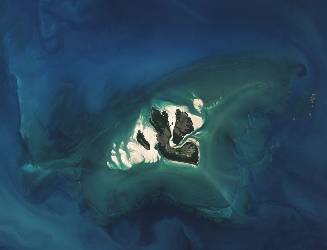
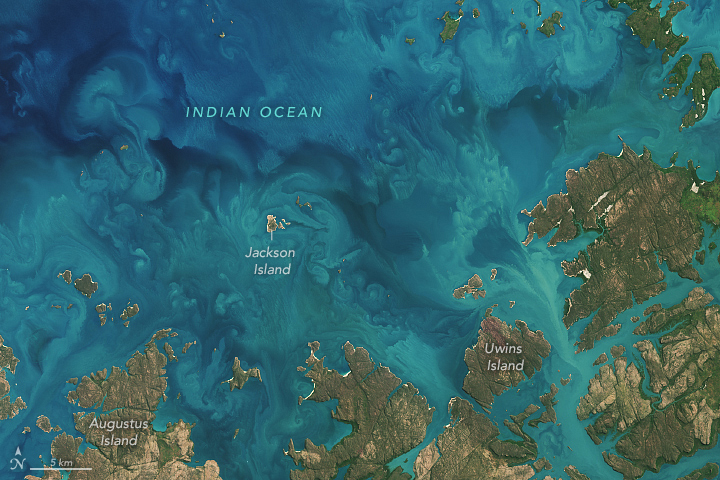
The blue-green waters along the coastline of Kimberley, in northwestern Australia, are constantly in flux.
The region’s large tidal currents stir up sediment in the shallow waters of the continental shelf to create colorful patterns.

Sediment swirled between rocky islands of the Bonaparte Archipelago, making the water appear turquoise in this image, acquired April 22, 2024, by the OLI (Operational Land Imager) on Landsat 8.
Beautiful scenes like this are common off the 20,000-kilometer-long Kimberley coast, which has one of the largest tidal ranges (up to 11 meters) in Australia and the world.
The tidal currents stir up sediment from the seafloor and incoming water from Western Australian rivers, generating colorful swirls in the water.

Visualization with the GeoGarage platform (AHS nautical raster chart)
 
Kimberley has been touted as having one of the world’s least human-impacted coastal zones.
The remote area supports a large range of marine habitat types including mangroves, seagrass beds, and coral reefs, which harbor a rich diversity of living things, such as fish, reptiles, marine mammals, and phytoplankton.

Phytoplankton—tiny plant-like marine organisms and the foundation of the marine food web—might also be contributing to the colorful water in this image.
Sediment particles in the upper ocean are often bound together with larger phytoplankton, such as diatoms, dinoflagellates, and ciliates.
However, it is not possible to discern the density and type of phytoplankton present based on this satellite image alone.

Some modeling studies estimate that climate change may reduce phytoplankton productivity by up to 20 percent by 2100.
But in the waters along the Kimberley coast, certain types of these plant-like organisms are thriving.
A 2020 study of sediment cores found that the populations of diatoms and dinoflagellates along a large section of the coast have grown by 150 to 300 percent since the 1950s.
The authors posited that increases in rainfall and cyclone activity in northwestern Australia leave the waters well-mixed, allowing phytoplankton to flourish.
 
Links :

Friday, June 21, 2024

Chinese archaeologists recover 900 relics from two Ming dynasty wrecks

Shipwrecks filled with Ming Dynasty relics found undersea

From Maritime Executive

China's archaeological authority announced Thursday that more than 900 valuable relics have been recovered from two wrecks in the South China Sea, providing physical evidence for China's history-based claim to ownership over this area of international waters.

The wrecks, dubbed No.1 and No. 2, are located just off the southern tip of China's Hainan Island.
They were found accidentally, back-to-back, over the course of two days in October 2022.
 
An archaeological investigation on two ancient shipwrecks discovered in the South China Sea was launched in May 2023, opening a new chapter of China's deep-sea archaeology, according to a press conference held at this period in Sanya, south China's Hainan Province. 
During the first archaeological survey of the No.1 shipwreck, located near the northwest continental slope of the South China Sea, researchers successfully established a permanent underwater mapping foundation in the southwest corner of the shipwreck site. 
The preliminary search and investigation as well as image recording were also carried out, according to the National Cultural Heritage Administration (NCHA). 
In October 2022, two ancient shipwrecks were discovered at an underwater depth of about 1,500 meters near the northwest continental slope of the South China Sea. 
One mainly consists of porcelain relics, estimated to contain more than 100,000 pieces dating back to the reign of Emperor Zhengde of the Ming Dynasty (1506-1521). 
The other, No. 2 shipwreck, mainly contains a large number of wood logs. 
Through a preliminary study, it was determined that the ship in question was loaded with cargo and had sailed from overseas to ancient China. 
It dates back to the reign of Emperor Hongzhi of the Ming Dynasty (1488-1505). 
With the approval of NCHA, joint efforts between research institutes and a local museum will be made to carry out further archaeological investigations involving the two shipwrecks in three phases for about a year.
 
The sites sit at a depth of about 1,500 meters below the surface, making them the deepest Chinese wreck finds in the South China Sea.
Imagery provided by a state research institution shows few signs of the ships' structures, but stacks of cargo from both of the wrecks are neatly laid out on the bottom in rows.

"The hull, the wood or planks of the hull no longer exist.
They were all eaten by termites," explained Song Jianzhong, project leader of the archaeological investigation.

"They symbolize China's underwater archaeology has reached the deep sea and help us understand the marine civilization in China," said Song Jianzhong, a researcher at the National Center for Archaeology.
 
 
Robotics arms are used in the underwater discovery of a shipwreck wite
Courtesy of National Cultural Heritage Administration
 
Pottery items date the wreckage to the Ming Dynasty, roughly 1350-1650 AD.
Chinese researchers believe that both ships were operating on the trade lane now known in China as the Maritime Silk Road.

"The cargo [of No.1] was mainly Jingdezhen [Ming dynasty] kiln porcelain, and it is speculated that it was a private merchant ship that departed from Fujian or Guangdong and headed for a trade transit point such as Malacca," said Song Jianzhong, research librarian of the National Cultural Heritage Administration (NCHA) Archaeological Research Center, in a statement last year.


 courtesy of CCTV
 
The NCHA investigated the two sites using the research sub Deep Sea Warrior in 2023-24.
According to the agency, 890 relics were recovered from wreck No.1, including pottery, porcelain and copper coins.
The No.2 wreck's cargo was made up of logs (ebony, which sinks in water), and 38 items of value were recovered, including pottery and deer antlers.
The contents of the cargoes demonstrate both export and import activity, according to the NCHA, on a route with modern geopolitical importance to Beijing.

The Institute of Deep Sea Science and Engineering of the Chinese Academy of Sciences provided technical assistance for reaching the depth of the wreck sites.
The NCHA's previous projects have focused on shallow-water wreck sites, within the reach of commercial diving techniques - but with an advanced deep-sea submersible, the agency was able to expand its capabilities.
The work at the No.1 site started with a photogrammetric survey of the wreckage field, followed by relic extraction.
The team said that it took great care and followed strict procedures to avoid crushing the pottery with the sub's manipulator arms, or smashing it during the hoisting and recovery of the sub at the surface.


Images courtesy Institute of Deep Sea Science and Engineering, Chinese Academy of Sciences

The discoveries align with China's objective to establish a record of past Chinese maritime activity.
Beijing claims sovereignty over the overwhelming majority of the South China Sea under its "nine-dash-line" policy, underpinned by a historical record of Chinese navigation in the region.

In 2016, the Permanent Court of Arbitration in the Hague dismissed China's claim to 90 percent of the South China Sea as inconsistent with the UN Convention on the Law of the Sea.
UNCLOS defines the limits of national control based on physical distance from land - not historical presence on the water.
China has ignored the ruling and continues to press its claims, often by force.

"The discovery provides evidence that Chinese ancestors developed, utilized and traveled to and from the South China Sea, with the two shipwrecks serving as important witnesses to trade and cultural exchanges along the ancient Maritime Silk Road," said Guan Qiang, deputy head of the NCHA, in a statement Thursday.
"This deep-sea archaeological investigation, integrating China's deep-sea science and technology, and underwater archaeology, marks the country's achievement of a world-class level in deep-sea archaeology."
 
Links :

Thursday, June 20, 2024

Was the “Odyssey” originally set in the Baltic?


If the Homeric epics truly originated in the Baltic rather than the Mediterranean, this could very well be the route that Ulysses took to get home from Troy – in Finland – to Ithaca – in Denmark.
Freezing cold, night battles, and a wrong-sized Hellespont: all clues that Ulysses sailed the Baltic instead of the Mediterranean.
(Credit: u/TheMightyGoatMan, Reddit)

From BigThink by Frank Jacobs


The Trojan War was fought in Finland and Ulysses sailed home to Denmark, says one controversial theory.The Iliad and Odyssey, Homer’s twin epics, seem to contain signature details suggesting these stories took place in particular settings.

Where? Not the Mediterranean but the Baltic, writes an Italian amateur historian.

So, is mythical Ithaca really the Danish island of Lyø? Other explanations are available.

Had he not wrapped himself in a discarded cloak, Ulysses would have frozen to death at Troy.
Our hero’s host, Eumaeus the swineherd, hears the story and gets the hint: He loans Ulysses a cloak, because again, the night is freezing cold.

This part of Homer’s Odyssey doesn’t sound very Mediterranean.
Sprinkled through Homer’s twin epics, Felice Vinci spotted a heap of similar anecdotes that pointed away from the traditional setting of the Iliad, an account of the Trojan War, and the Odyssey, the story of Ulysses’ 10-year journey home to Ithaca after the fall of Troy.

For Vinci, a nuclear engineer by training and an amateur historian by passion, the clues added up to a shocking revelation: Those Homeric stories, cornerstones of ancient Greek and modern Western culture, do not take place in and around Greece, in southern Europe, but rather near the Baltic Sea, in northern Europe.

Extraordinary claims, extraordinary proof


Extraordinary claims require extraordinary proof, and Vinci produces some compelling pieces of evidence.
In his 1995 book Omero nel Baltico (translated as The Baltic Origins of Homer’s Epics), he points to:numerous climate anomalies in Homer’s works, for example cool, foggy weather and snow dusting the shields of the warriors
various geographic discrepancies, such as references to the “wide Hellespont,” which would fit better with the broad Gulf of Finland
several topographic correspondences — for example, Troy could be the southern Finnish town of Toijala, Chios the Estonian island of Hiiumaa, and Pylene the northern German town of Plön
reports of fighting at night, which would be possible thanks to long summer days in northern latitudes
the boats in the Odyssey having two prows so they can be pointed in either direction, just like typical Viking longships

From these fragments, Vinci extrapolates a grand narrative, which goes something like this: During the Holocene Climate Optimum, from roughly 7500 to 5500 BC, northern Europe was much warmer than it is now, generated rich harvests, and hosted a vibrant, proto-Greek Bronze Age civilization.

The Dorian invasion (oral epics included)

When the climate cooled, that civilization migrated south, to Greece.
This would be the so-called Dorian invasion, with newcomers from the north taking over from the pre-classical inhabitants of Greece.
Those Dorians brought from the north their culture, including northern original place names that were recycled for use in the eastern Mediterranean, as well as the orally transmitted epics that would be refashioned into the Iliad and Odyssey.

If that’s true, the Trojan War was a Nordic conflict and the Odyssey was a Baltic adventure.
Vinci obliges, by matching key places in the epic stories to locations in northern Europe.
As the map shows, the “ringing plains of Troy” would have been situated in southern Finland.

And it’s not just that starting point of the Odyssey that is outlandish; the other stops along the way are equally strange.
Vinci identifies the location of the Greek city of Thebes with that of the Swedish capital of Stockholm.
Hellas — the classical name for Greece — is in Estonia, while northern Poland is Egypt (and the location of the Egyptian city of Thebes).


Illustrious Athens once stood where the southern Swedish town of Karlskrona now rears its roofs: charming and baroque, but definitely less grand and much more recent.
Copenhagen is Mycenae, while Ogygia, the island where the nymph Calpyso held Ulysses captive for seven years, is one of the Faroe Islands.

The cyclopes lived in Norway’s Tosenfjorden.
Hades, the pagan Greek underworld, was in Russian Karelia.
And Ithaca, the mythical home of Ulysses, is the tiny and otherwise rather unremarkable Danish island of Lyø.

The underworld — in Russian Karelia


Vinci spins a fantastic tale, but does any of it hold water? There is very little archaeological evidence of a highly developed Bronze Age civilization in the Baltic region during the time that would fit his story.
And the evidence he presents is cherry-picked, often ignoring clues to the contrary.
In the words of one critic, Vinci “uses faint indicators to draw enormous conclusions, and hides or is blind to contradicting evidence,” in the manner of many popular books about UFOs, mermaids, or Atlantis.
 

Ulysses tied to the mast of his ship, so he can hear the seductive song of the Sirens, while his shipmates have their ears plugged with wax – a scene set in the Lofoten archipelago of northern Norway, according to Felice Vinci.
Mosaic from the Bardo National Museum in Tunis.
(Credit: Dennis Jarvis, CC BY-SA 2.0 DEED)

Still, Vinci is not alone.
The identity of Ithaca, so vaguely described by Homer, continues to exercise writers and historians.
Some examples from recent centuries:
  • The 19th-century Belgian amateur historian Théophile Cailleux placed the scenes of Homer’s epic on the European shores of the North Atlantic, but farther south than Vinci: Troy near Cambridge in England and Ithaca near Cadiz in southwest Spain.
  • Around that same time, the English novelist Samuel Butler hypothesized the Odyssey was written by a Sicilian woman (who inserted herself into the work as Nausicaa, the young daughter of King Alcinous), and that the setting of the epic is Sicily itself.
  • The Greek historian Manolis Koutlis, to name a last but by no means final example, identified Ithaca as Faial, one of the Azores islands in the middle of the Atlantic Ocean.
So, did Ulysses sail the Baltic and North Atlantic on his long journey home? Perhaps the best reply to that question is a saying popular in Vinci’s native Italian: Se non è vero, è ben trovato (even if it’s not true, it’s a good story).

Wednesday, June 19, 2024

The enemy in the job board

 
In 2018, shortly after the United States reimposed sanctions on Iran for the country’s refusal to scrap its nuclear weapons program, what’s now known as the shadow fleet emerged.
Iran enlisted a fleet of vintage tankers to transport sanctioned oil surreptitiously and without US or EU oversight.
With Russia’s invasion of Ukraine and the imposition of war-related sanctions by Ukraine’s Western allies, the Russian government has become the latest to turn to the shadow fleet.
Photo by C-images/Alamy Stock Photo

From Hakai Mag by Nathaniel Peutherer

Ukrainian Sailors Are Using Telegram to Avoid Being Tricked Into Smuggling Oil for Russia 
 
Contract seafarers in Ukraine are turning to online whisper networks to keep themselves from being hired into Russia’s sanctions-busting shadow fleet.

A new video appears on the social media network Telegram: footage of the smoking area aboard a large vessel.
The curtains are ripped, the lights are broken, and ash and glass litter the floor.
“This is how they drink on our ship,” says the young Ukrainian deck worker filming the scene, turning to show the furniture thrown to the corner of the room.
“I’m freaked out.”

A Telegram administrator asks the deck worker if he can share the vessel’s name.
They change the ship’s name multiple times a year, replies Feliks Bondar, whose own name has been changed for this story.
“I don’t even know what name to tell you,” he writes in Ukrainian.
“Our ship was originally called Eagle, but in Venezuela, we were Matadorand then Shoyo Maru.”

A chorus of similar messages had flooded the chat in recent months: stories of dangerously rundown ships, operators withholding pay, abandoned crew members, and vessel owners changing ship names or manipulating their automatic identification systems (AIS)—the global network meant to help ships recognize each other.

The Telegram group hosts over 8,000 sailors.
Some are fresh out of maritime college, others are seasoned captains.
All are drawn to the group by a desire to stay safe on the high seas.
By telling their stories and naming names—when they can—these sailors have been gathering information about problematic vessels, detailing everything from those with low-quality food to ships where crews often experience pay delays.

But in recent years, as more sailors are finding themselves unwittingly involved in the so-called shadow fleet—smuggling oil for Iran, Russia, or other clients that have been hit by strict sanctions to restrict their sales of oil—the social media whisper network has evolved.
As well as a place to find a reputable employer, it’s become something else: a way for seafarers to avoid helping the other side of a war.

LIFE AS A contract seafarer has never been easy.
Workers frequently hop from ship to ship, contract to contract, and country to country.
But the rise of the shadow fleet—along with Russia’s war in Ukraine—poses a new kind of risk.

About a year and a half ago, in early 2023, Bondar sought out the seafarers’ Telegram network after a particularly troubling gig.
Booked to the job by an Ukraine-based crewing agency, Bondar found that the name of his assigned vessel had been painted over, and the AIS was, once again, unplugged.
A note on top of the device warned seafarers not to turn it on.

After a six-month voyage smuggling sanctioned oil to China, Bondar says the crew was told its next operation would begin in Koz’mino, Russia.
Russia’s most recent invasion of Ukraine had begun while he was at sea and had already been underway for over four months.
Bondar and the other Ukrainians on board refused to work smuggling Russian oil.
The ship’s operator allegedly fired them all, ditching them at the nearest port in China.

“Nothing will surprise me anymore,” Bondar wrote in the Telegram group.
“I have accumulated enough ‘sea stories’ for the rest of my life.”

The war in Ukraine is taking a huge toll, not only on the soldiers on the front lines but on Ukrainians worldwide.
Earlier this year, Stella Maris, an English charity committed to seafarer well-being, reported that depression and anxiety are rising among Ukrainian seafarers.
These Ukrainians are trying to provide for their families while worrying about the safety of their loved ones, the future of their homeland, tensions with Russian seafarers, and the fear of conscription if they return home.
With Russian troops capitalizing on Ukraine’s temporary weapons shortage—caused by the delayed delivery of Western aid—the plight of Ukraine’s people, including its seafarers, shows little sign of letting up.

Bondar’s was not an isolated incident.
Recruitment for the shadow fleet is a complex web of crewing agencies, shell companies, and absentee ship owners.
Crewing agencies, tasked with finding seafarers to fill contracts, often know very little about the ships, their cargo, or their owners, creating the ideal conditions for deception.
But maritime recruitment data shows that at least six Ukrainian crewing agencies have been involved in sourcing seafarers for 10 Russian ships smuggling oil since Russia began its invasion of Ukraine in February 2022.


Starting from a list of known Russia-affiliated oil smuggling vessels kept by the nonprofit watchdog United Against Nuclear Iran, journalist Nathaniel Peutherer was able to cross reference the ships on that list against old job postings by using vessel identification numbers kept by the International Maritime Organization.
The names of vessels involved in the shadow fleet are regularly changed, but their identification numbers do not vary.
For cases where the ship owners hid their vessel’s identification number, Peutherer used a specific set of ship characteristics to match job postings to a particular vessel.
Other vessels were confirmed directly by contacting crewing agencies.
These alternative approaches make tracking vessels through their myriad identity changes somewhat possible.
Photo by Em Campos/Alamy Stock Photo


Mazhnuna Karaca, head of operations at Dese Crew Management, a Ukraine-based crewing agency, says she only found out after the fact that her company had been unintentionally trying to solicit seafarers for illegal Russian oil-smuggling operations.

On February 8, 2023, an advertisement seeking crew for a large oil tanker appeared on maritime job forums.
The ship’s official identification number along with anything else that might easily identify the vessel were conveniently absent.
Karaca, however, confirmed the ship to be the Danica, a vessel that had been featured on a shadow fleet watch list compiled by United Against Nuclear Iran, a US-based nonprofit, since December 2022.

Ships such as the Danica that transport illegal oil violate sanctions meant to restrict the economic opportunities of nations that threaten global security.
In so doing, the vessels’ owners enable those nations to fund their activities.

Dese Crew Management tried to recruit seafarers for the Danica and two other ships that were later revealed to be part of the Russian shadow fleet.
Fortunately, says Karaca, her company never succeeded in sending anyone to the Danica or any of the other known shadow fleet ships during their illicit operations.
But only “because rumors spread quickly between sailors,” she says.

Each time Dese found a suitable candidate for the Danica, the sailor would abruptly change their mind and refuse to board.
That had puzzled Karaca and her staff—until she learned about a different online seafarer whisper network, where details were whirling.

Among seafarers, the company that owns the Danica had a reputation.
Digging in deeper, Karaca says the company was originally named Sand & Sea Marine—before it rebranded to Linda Shipping in an attempt to escape its reputation for unsafe conditions, withholding pay, and abandoning crew.

Once aware of the Danica’s and the other ships’ involvement in the shadow fleet, Dese Crew Management promptly blacklisted the vessels.
Other crewing agencies, however, have been less helpful.
On Telegram, some seafarers even believe that crewing agencies have infiltrated the group to post fake positive reviews about the conditions aboard vessels for which they are trying to recruit crew.

Fortunately, the seafarers aren’t so gullible: “This is automated bots or the manager has told everyone to write for them,” one sailor wrote below a suspiciously positive set of reviews.
“They shout so much that they are not scammers that I think the opposite,” another adds with a laugh.

DURING AN ASSEMBLY in December 2023, the International Maritime Organization (IMO)—the branch of the United Nations tasked with managing international maritime transport—urged member states to do more to derail the shadow fleet.

The IMO has encouraged cooperation between coastal member states to help identify suspicious ship-to-ship transfer operations and AIS manipulation, citing risks to “the safety, well-being, and potential criminalization of the crew.” 
The European Union has called for similar actions while also announcing new sanctions that require the details of any tanker being sold to a Russian entity—including information about the buyer and seller—to be disclosed publicly, opening the door for governments to step in and block the sale if they think the ship might find its way into the shadow fleet.

So far, international regulators have yet to comment on the role crewing agencies play in supplying workers to the shadow fleet.
Future guidance could extend the Maritime Labour Convention, calling on member states to ensure that independent crewing agencies operating within their territory receive the IMO numbers of the vessels they work with before advertising positions to seafarers.

Until the shadow fleet is brought under control, seafarers will continue whispering over the water and doing what they can to keep themselves—and each other—safe.

Links :

Tuesday, June 18, 2024

China is leading the world in naval sensing and navigation R&D

 
The Lockheed "Dark Ice" quantum magnetometer, used for object detection and satellite-free navigation (Lockheed file image)
 
From ASPI by Jenny Wong-Leung and Dannielle Pilgrim


China’s research in several advanced sensor technologies vital to military navigation and targeting is overwhelmingly ahead of the three AUKUS partners, the United States, United Kingdom and Australia.

Even if the three team up with likeminded Indo-Pacific countries Japan and South Korea, they do not match the Chinese output in high-impact research.

This is a key finding of ASPI’s latest update to its ground-breaking Critical Technology Tracker which compares levels of high-impact technological research worldwide.
The update, released today, focuses on two key technology clusters in which breakthroughs will have major implications for future industrial, societal and military capabilities—advanced sensors and biotechnologies.

The tracker has now measured the amount of high-impact research by country across 64 technologies.
China maintains its overall dominance, leading in 53 technologies against 11 for the US.
This article focuses on advanced sensors.
A second Strategist piece will tackle biotechnology.

High impact research is a key performance measure of scientific and technological capability.
For example, the recent boom in Artificial Intelligence (AI) applications such as ChatGPT have grabbed global attention seemingly out of nowhere but are in fact based on decades of quiet research and advances across AI and computing.

Although North America has the largest share of the $200 billion remote sensor market with 41%, the tracker indicates China’s strong future trajectory through its huge share of papers in the top 10% of highly cited publications, especially in inertial navigation systems (44%), photonic sensors (43.7%), multispectral and hyperspectral imaging sensors (48.9%) and sonar sensors (49.4%).

The advanced sensor technologies included in the tracker are used for sensing, timing and navigation.
They are comprised of devices with extremely sensitive detection capabilities for magnetic and gravitational fields, light and radio waves, and measuring time with atomic precision.
The seven technologies are atomic clocks, inertial navigation systems, gravitational force sensors, magnetic field sensors, multispectral and hyperspectral imaging sensors, satellite positioning and navigation, and radar.

Three sensor technologies covered in previous releases are—sonar and acoustic sensors, photonic sensors and quantum sensors.


Our table shows our analysis of advanced sensor technologies and identifies the lead country with the highest percentage of papers in the top 10% of highly cited papers.
The Critical Technology Tracker shows that China leads in seven of the 10 advanced sensor technologies—reflecting the massive effort and investment Beijing has made in these areas in recent years.

Four of these technologies have a high technology monopoly risk and can translate to future technological dominance.
However, the stark nature of the challenge becomes clearer when we add the outputs of the AUKUS countries and other plausible partners.

Even if the three AUKUS partners join efforts, they still lag badly in six out of the seven technologies in which China leads, and they are barely neck-and-neck in the seventh, magnetic field sensors.

And if AUKUS were to expand and work with Japan and South Korea, they still wouldn’t catch up in those six fields.
When Europe is added, the multinational grouping would creep ahead in radar and satellite positioning and navigation, but would still trail behind China in the other fields.

In a recent summit with the leaders of Japan and South Korea, US President Joe Biden reaffirmed US intentions to increase military and economic ties in a trilateral partnership.
Japan, meanwhile, has expressed an interest in joining the non-submarine aspects of AUKUS technology collaboration—a gesture well received in the AUKUS capitals.

Each of these technologies is vital to our economies, our militaries, and our everyday lives.
Global positioning systems (GPS), for example, are used by billions of people every day and are indispensable for defence forces for everything from situational awareness to guiding munitions.
But their accuracy depends on precise timing using signals from atomic clocks on the ground and several GPS satellites in orbit.

Inertial navigation systems—which have long been an essential part of missile guidance—use a range of sensors to calculate the position of an object relative to its starting reference point without the need for continuous GPS references.
This can become important if GPS networks are hit by jamming and spoofing attacks.

Likewise, ground-penetrating radar sensors—equally less reliant on GPS—can scan and map the ground with radio waves, which is useful for forensics, archeology and landmine detection.

Magnetic and gravitational field sensors have important applications in and beyond navigation.
They can peer through dirt, rock and water to reveal information about the lay of the land.
When coupled with a drone, these sensors provide valuable insights in land surveys and mineral exploration.

Gravitational field sensors can be used to monitor seismic and volcanic activity and detect hollow cavities and hydrocarbon reserves.

Quantum sensors can also be made to measure magnetic and gravitational fields but with higher sensitivity, better spatial resolution and a faster response rate.

Photonic sensors have applications in medicine (measuring blood saturation or glucose levels), environmental monitoring (measuring pressure and temperature), biochemical sensing (toxic chemicals) and autonomous systems (with laser imaging and detection).

Commercial satellite imaging is already highly capable, with a spatial resolution of a 25cm × 25cm pixel on earth, the size of a laptop.
However, multispectral and hyperspectral imaging provides additional information by capturing specific colours, enabling the detection of chemical elements, for example, which is useful for agriculture, mineral prospecting and many other fields.
It could, for instance, detect the spectral signature of chlorophyll—a key compound in green plants—across an area of land to counter ‘greenwashing’ by countries trying to inflate their carbon reduction measures.
For example, earth images from Hisui, Japan’s hyperspectral satellite imager launched in October 2022, have the spectral resolution required to inform climate policy making.

Radar has an advantage over photonic sensors in that it can ‘see’ through clouds.
However, radar’s spatial resolution is directly related to the ratio of the wavelength to the length of the antenna, where antenna size soon becomes impractical.
The introduction of synthetic aperture radar (SAR) imaging eliminates this problem with a spatial resolution that depends on the size of the ‘aperture’.
SAR was used widely by the military in the 1970s but is now a growing industry in the commercial satellite imaging sector with a market share of US$3.7 billion in 2022.

Seven of the 10 advanced sensor technologies are led by two China-based institutions, the Chinese Academy of Sciences (CAS) and Wuhan University.
CAS is the world’s largest research organisation, with over 100 institutes and three universities under its umbrella.
In our tech tracker, Wuhan University distinguishes itself as the top institution in inertial navigation systems, satellite positioning and navigation and multispectral and hyperspectral imaging.
There are existing concerns around Wuhan University’s access to data from international affiliations like the international GNSS which could potentially support China’s People’s Liberation Army.
In 2019, Wuhan University signed a memorandum of understanding with the United Nations Institute for Training and Research (UNITAR) for collaboration on AI research and innovation capacities for remote sensing through the UN Satellite Centre (UNOSAT).
Recently, Wuhan University garnered attention in its successful experiment in giving AI complete control of its satellite in space temporarily, strengthening this collaboration. Global agencies like the UNITAR must ensure that the use of their satellite data is restricted to global applications and challenges.

The Critical Technology Tracker reveals that Beihang University in Beijing is the world’s top performing institution in magnetic field sensors and is significantly ahead of other institutions, producing 6.6% of the world’s top 10% most highly cited research papers in the field compared to the second and third ranked institutions, University of Nottingham in the UK (2%) and MIT in the US (1.9%) respectively.

While, overall, the US is the top performing country in gravitational field sensing, the Chinese Academy of Sciences leads the institutions list and is the only Chinese university in the top 10 with the University of California system and CALTECH claiming the second and fourth places respectively.
Germany takes the third place in the country ranking with the Max Planck Institutes ranked third in gravitational field sensors.
The UK features prominently with the University of Cambridge and University College London in fifth and sixth places.

Monday, June 17, 2024

Shark attacks are rising in Australia. Technology is helping stop them.

Drone footage shows a shark swimming alongside surfers at Birubi Beach, Australia.
(Video: Department of Primary Industries)

From WP by Michael E.Miller

Australia is a nation of beaches.
But a growing incidence of shark attacks is forcing authorities to turn to drones and artificial intelligence to try to keep beachgoers safe.

COFFS HARBOUR, Australia — It was just before noon when Nathaniel Woodcock returned to the beach with fresh batteries for his drone.
It was the height of the Australian summer, and the 21-year-old was spending another day scanning the emerald waters from above.

He spotted something headed toward the swimmers and surfers:
A seven-foot shadow. A great white shark.

Woodcock radioed lifeguards, then activated the warning system, he later recalled, recounting the incident to a reporter.
“Attention, beach users,” the drone blared.
“There is a shark in your area. Please exit the water.”

As swimmers scrambled onto the beach, Woodcock’s eyes were glued to his screen, where he saw the shark following a school of fish to shore.
As a wave broke, the shark suddenly surged toward the beach.
Then, to everyone’s relief, it headed back out to sea.

Woodcock is one of hundreds of drone pilots enlisted in a high-tech push to stem an increase in shark attacks in Australia, a country of 100,000 beaches where most people live near the coast.

But as the number of attacks has grown recently — in Australia and around the world — the nation is moving away from traditional shark-fighting tools like nets and adopting new technologies.

Swimmers at North Bondi Beach, near Sydney, this past January, at the height of the Australian summer. 
(Photos by Matthew Abbott for The Washington Post)
 
A lifeguard keeps watch from the main Bondi Beach tower on Jan.
26 — Australia Day, one of the busiest beach days of the year.

 
Australia now has the world’s largest coastal drone-surveillance operation and is installing nonlethal traps, or drumlines, that alert authorities when a shark takes their bait.
These are enabling authorities to monitor sharks like never before — and have turned Australia into a laboratory for ways to prevent shark attacks.

Drone pilots are just the beginning.
Officials are testing remotely operated and long-distance drones, as well as ways to incorporate artificial intelligence.
But until such technology is widely deployed, many areas remain unmonitored.

Source: Australian Shark Incident Database

Woodcock’s intervention on a beach in Mollymook, three hours south of Sydney, in January at the height of the Australian summer showed the new technology’s lifesaving power.
But it also revealed the gaps that remain: The great white hadn’t been tagged with a tracker, so a listening station couldn’t detect it.
And had the shark appeared a few hours later, Woodcock, the sole drone operator that day, would have been off duty.

There were 10 fatal shark attacks globally last year, and four of them were in Australia, according to the University of Florida’s International Shark Attack File.
Although this was lower than the six deaths in Australian waters in 2020, the trend has been up: There were only one or two fatal shark attacks a year between 2012 and 2018, with none in 2019.

Last year a woman was bitten by a bull shark in Sydney’s harbor — the first attack in the waterway in a decade.
The incident and a deadly attack in Perth’s Swan River a year earlier have stirred fears that warmer waters caused by climate change are making sharks linger in some locations, just as increasing temperatures and populations drive more people to the ocean.


Drone pilot Paolo Cattaneo monitors the water for sharks on Jan.
26 near Tamarama Beach, Australia.
(Video: Matthew Abbott/The Washington Post)


Swimmers at Bondi Beach.
 
An ancient menace

High above the sunbathers and bodybuilders of Bondi Beach sits an Aboriginal rock carving showing what may be humankind’s first recorded shark attack.
British colonists found Sydney harbor “full” of the animals.
And when Arthur Conan Doyle, the creator of Sherlock Holmes, visited in 1920, he marveled that “the fact that the water swarms with sharks seems to present no fears to these strong-nerved people.”

Yet, even those strong nerves have occasionally frayed.
When attacks increased in the 1930s because of waste near Sydney’s shore, authorities put nets around popular beaches.

Nearly a century later, the nets are still in place: There were 51 along 150 miles of coastline near Sydney this Australian summer, managed by the New South Wales Department of Primary Industries.

State workers check the nets every few days.
“Target species” — great white, tiger and bull sharks, which cause most of the serious bites — found alive are fitted with acoustic tags and shepherded out to sea.
But most wildlife caught aren’t sharks, let alone dangerous ones, and are already dead by the time they are discovered.


Source: NSW Department of Primary Industries

“Shark nets create an incredible cost on other marine life,” said Duncan Heuer from Saving Norman, a group devoted to Bondi’s critically endangered gray nurse sharks.

But the biggest argument against nets is that they don’t work, he says.
They sit about 13 feet below the surface, end well above the ocean floor and are only 500 feet long.
Nearly half the time that a shark gets caught, it’s already on the shore side of the net, he added.
And 17 percent of unprovoked attacks have happened at netted beaches, according to DPI.

Nets give beachgoers false security, making politicians reluctant to get rid of them, said Chris Pepin-Neff, an expert on the public policy of shark attack prevention.
“It’s smoke and mirrors,” they said.

Lifeguards, in blue, and lifesavers, in red and yellow, work to keep beach visitors safe on Bondi Beach.

 
A swim group gathers shortly after exiting the water at Bondi Beach.

DPI still says nets reduce shark encounters, but its stance has softened.
A recent study whose authors included DPI scientists said it “could not detect differences in the interaction rate” between sharks and humans at netted vs.
non-netted beaches since the early 2000s.
Last year, half the communities with nets voted to remove them.

Ultimately, it’s the state government that will decide.
New South Wales Premier Chris Minns wants to get rid of the nets — with a caveat.
“I’ve got to have confidence that the replacement, the new technologies, are as good,” he said last year.

Samara Bye, a contractor for the New South Wales Department of Primary Industries, deploys a SMART drumline off Coffs Harbour, 300 miles north of Sydney.
 
A new strategy

On a muggy morning in late January, that new technology lined the deck of a small fishing boat chugging out of the Coffs Harbour marina, 300 miles north of Sydney.
As dawn streaked the sky, Samara Bye tossed an anchor over the side of the boat.
Then she threw in two buoys attached to a solar-powered, satellite-linked sensor.
Finally, she chucked in a mullet on a six-inch hook.

She was fishing for sharks.

The DPI contractor was setting 15 nonlethal, or “SMART,” drumlines.
(“SMART” stands for “Shark Management Alert in Real Time.”)


“People hear ‘drumline’ and think we’re killing the sharks, but we’re not,” said Paul Butcher, a DPI scientist.
He contrasts the technology to Queensland state’s use of traditional drumlines, which are left overnight, are deadly and have drawn outrage.


The new drumlines were first implemented in New South Wales in 2015, after four shark attacks — one fatal — in as many weeks sparked fear in the normally laid-back surfer communities near Byron Bay, north of Coffs Harbour.
“The feeling was, ‘You’ve got all those shark nets down in Sydney, but what are you doing for us up here,’” recalled Liz Brennan, a communications coordinator for DPI.


Paul Butcher, principal research scientist with the NSW Department of Primary Industries in Australia, tags a great white shark.
(Video: Department of Primary Industries)

The program, which has grown from a few drumlines to 305, helps keep people safe: Sharks tend to avoid for a few months places where they’ve been caught, Butcher said.
But it also helps humans learn about the animals via DNA and tracking data.

The drumlines work with 37 listening buoys, which alert lifeguards and some beachgoers when a tagged shark approaches.

The idea is to eventually replace Sydney’s shark nets with the newer, nonlethal technologies.

“There just has to be a government at some stage that, when they are happy with the research, will swap shark nets out for drumlines and drones,” Butcher said.

Samara Bye throwing a baited drumline overboard.
She repeats this process every 1,000 yards or so along the Coffs Harbour coastline.

DPI scientist Paul Butcher, left, and colleague James Tulloch pick up a drumline after getting a false alert that a shark had taken the bait.

The new tech isn’t perfect.
Sometimes the drumlines have false alarms.
Glare or seagrass can prevent drone pilots from spying sharks, while bad weather can ground some machines.
And drones are only as good as their operators, who must stay alert for hours.

“It’s a lot of coffee,” Paolo Cattaneo, another drone pilot, explained as he scoured the waves at Tamarama, not far from Bondi.
Like the drumlines, the drone program has grown from a small experiment in 2017 to the biggest such operation in the world.
More than 200 paid pilots monitor 50 locations along the state’s coast from 9 a.m.
to 4 p.m.
during four busy school-holiday periods.
There are also has a few hundred year-round volunteers.


Lifesavers circle a shark in October 2019 in the waves at Birubi Beach, Australia.
(Video: Department of Primary Industries)

New South Wales used to use planes, which released red powder if they spotted a shark, said Pepin-Neff.
Then the state switched to helicopters, but they proved expensive and ineffective.

As on the battlefield, drones are proving cheaper and more efficient on the beach.
If Cattaneo spots something, he drops his drone to 50 feet and starts recording.
Shark diagrams on his monitor help him gauge an animal’s size.
If it’s a great white, tiger or bull shark and it gets within about 1,000 feet of the beach, he’ll tell lifeguards to clear the water.
In the six weeks over Christmas, as the Australian summer was in full swing, drone pilots spied 164 sharks.

DPI is experimenting with AI to help drone pilots identify dangerous species.
It is also testing “drones in a box” — stored at beaches and deployed remotely — and long-range drones that can fly for 60 miles.

It’s too soon to say if this will stem rising shark attacks.
But so far, in five years, there hasn’t been a shark-human interaction at a beach protected by either drones or the new drumlines, compared with 19 in a similar period before.

Some warn against putting too much faith in technology, however.
The program costs New South Wales about $14 million a year, more than many places can afford.
And even in the future, if Australian beaches are continually patrolled by drones, it still won’t be possible to prevent every shark attack.

“When you enter wildlife’s domain,” Pepin-Neff said, “you do it at your own risk.”

Paul Butcher and his team of shark researchers make their way through the Coffs Harbour marina at sunrise.

Links :

Sunday, June 16, 2024

‘Oceanus’ - the world’s first long-range autonomous research vessel


Introducing 'Oceanus', the world’s first long-range autonomous research vessel - set to usher in a new era for net zero oceanography and advanced international marine research.