Montgomery Reef Revealed
From NASA by Adam Voiland
The Kimberley coast of Western Australia has one of the largest tidal ranges in Australia and the world.
At Montgomery Reef, in Collier Bay, water levels drop sharply at low tide, allowing the plateau-shaped reef to emerge several meters above the water level.
Visualization with the GeoGarage platform (AHS nautical raster chart)
Tidal shifts are particularly noticeable in this area because of the flat, shelf-like terrain along the Kimberley coast.
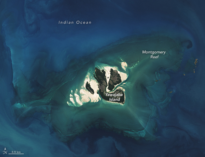
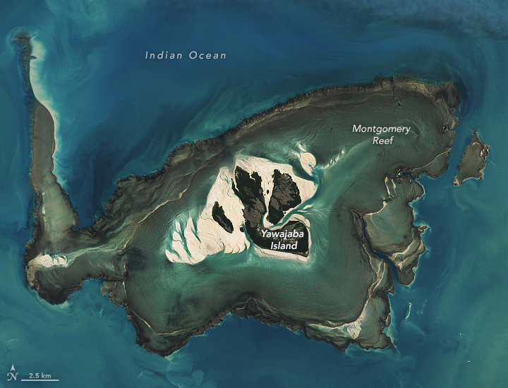
This pair of images shows the reef when the tide was high (left) and low (right) in 2024.
The high tide image was captured by the OLI-2 (Operational Land Imager-2) on Landsat 9 on April 21; the OLI (Operational Land Imager) on Landsat 8acquired the low tide image on April 29.
When the tide rises, the sandy islets and main mangrove-covered island, Yawajaba, within Montgomery Reef are visible, but the reef is mostly underwater and out of view.
During low tides, the water level can drop by as much as 10 meters (33 feet), revealing the expansive terraced structure of the reef and the network of shallow lagoons surrounding Yawajaba.
As the tide pours off the structure, the outward flow of water can grow tumultuous.
At times, whitewater cascading off the reef forms dozens of rivulets and small waterfalls that flow into deeper channels within the reef, a spectacle for tourists and a hazard for wildlife.
Fish, sea snakes, turtles, blacktop reef sharks, dugongs, and other creatures can be seen thrashing and tumbling off the coral platform as the water drains.
Animals are occasionally left stranded on exposed reef during low tide.
The structure of Montgomery Reef is not entirely a product of coral.
The feature was once a flat-topped terrestrial mesa made of dolomite and sandstone that formed some 1.8 billion years ago.
More recently, this ancient structure has been encrusted with a veneer of marine life, especially rhodolith—a free-floating type of coralline algae that adds much of the structure to the perimeter of the reef.
Communities of several types of hard and soft corals cover about 20 percent of the reef’s surface, particularly along the edges of pools and channels where the water is deeper.
Corals along the Kimberley coast, like those found on Montgomery Reef, are known for being unusually resilient compared to corals in other parts of Australia and the world.
They have adapted to withstand the swings in temperature that come with tidal variations, and to endure the exposure to elevated ultraviolet light and winds during low tide.
But even these rugged corals are not indestructible.
Following a marine heat wave in 2016, which was part of the third global bleaching event, scientists reported widespread coral bleaching at Montgomery Reef and other coral communities on the Kimberley coast.
In April 2024, the National Oceanic and Atmospheric Administration (NOAA) confirmed the world’s corals were in the midst of a fourth global bleaching event, but local reports of bleaching at Montgomery Reef have not emerged yet.
Heat stress maps from NOAA’s Coral Reef Watch indicate that corals to the southwest in Western Australia and those closer to the equator faced a greater risk of bleaching in mid-May 2024.
From NASA by Emily Cassidy
The blue-green waters along the coastline of Kimberley, in northwestern Australia, are constantly in flux.
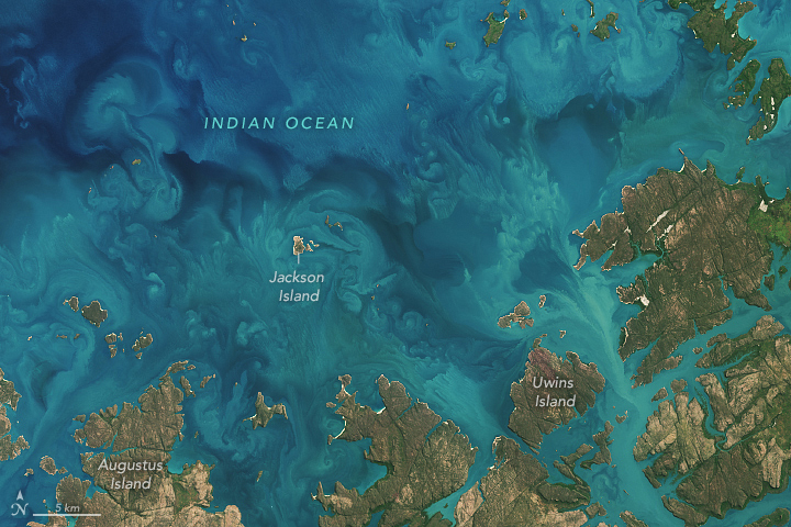
The region’s large tidal currents stir up sediment in the shallow waters of the continental shelf to create colorful patterns.
Sediment swirled between rocky islands of the Bonaparte Archipelago, making the water appear turquoise in this image, acquired April 22, 2024, by the OLI (Operational Land Imager) on Landsat 8.
Beautiful scenes like this are common off the 20,000-kilometer-long Kimberley coast, which has one of the largest tidal ranges (up to 11 meters) in Australia and the world.
The tidal currents stir up sediment from the seafloor and incoming water from Western Australian rivers, generating colorful swirls in the water.
Visualization with the GeoGarage platform (AHS nautical raster chart)
The remote area supports a large range of marine habitat types including mangroves, seagrass beds, and coral reefs, which harbor a rich diversity of living things, such as fish, reptiles, marine mammals, and phytoplankton.
Phytoplankton—tiny plant-like marine organisms and the foundation of the marine food web—might also be contributing to the colorful water in this image.
Sediment particles in the upper ocean are often bound together with larger phytoplankton, such as diatoms, dinoflagellates, and ciliates.
However, it is not possible to discern the density and type of phytoplankton present based on this satellite image alone.
Some modeling studies estimate that climate change may reduce phytoplankton productivity by up to 20 percent by 2100.
But in the waters along the Kimberley coast, certain types of these plant-like organisms are thriving.
A 2020 study of sediment cores found that the populations of diatoms and dinoflagellates along a large section of the coast have grown by 150 to 300 percent since the 1950s.
The authors posited that increases in rainfall and cyclone activity in northwestern Australia leave the waters well-mixed, allowing phytoplankton to flourish.
Links :


No comments:
Post a Comment