Saturday, October 26, 2024

Bikini atoll test

1946 Nuclear Bomb Testing at Bikini Atoll Document Archive (Map, Photos, Newspapers)
- click on the picture for HR -
or see dynamic zoom on Geographicus
 
81544 NGA current map
 

Links :


Friday, October 25, 2024

Azores create largest marine protected area in North Atlantic

A view shows Faja da Caldeira Santo Cristo, Azores, Portugal, March 30, 2022. 
Reuters/Pedro Nunes/File Photo Purchase LicensingRighs
 
Portugal has recently created Europe’s largest Marine Protected Areas network, helping protect the unique underwater ecosystems of the Azores.  

The regional assembly of Portugal's Azores Islands approved the creation of the largest protected marine area in the North Atlantic to reach international conservation goals well ahead of time.

 
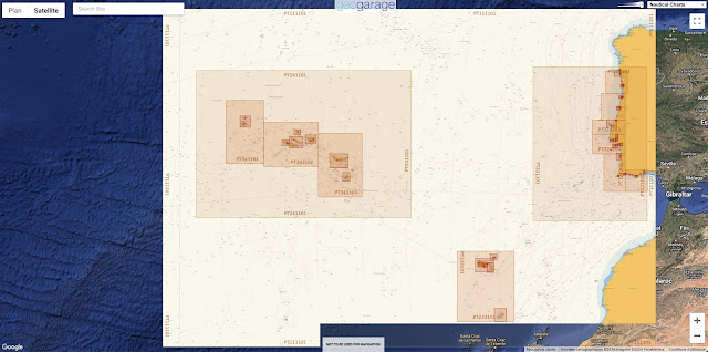
Acores (IHPT ENC) coverage with the GeoGarage platform
 
The approval late on Thursday places the archipelago at the forefront of global ocean conservation that aims to achieve the goals set by the United Nations of protecting 30% of the Earth's land and sea by 2030 under a global pact adopted last year.


A man looks over a cliff edge on the Vila Franca Islet, the exposed remains of a volcanic cone and a protected nature reserve, off Sao Miguel Island in the Azores archipelago, Portugal July 2, 2024.  
Reuters/Darrin Zammit Lupi/File Photo Purchase Licensing Rights
 
The network will encompass almost 300,000 square kilometres (115,830 square miles) and ensures the preservation of underwater mountain ranges and vulnerable marine ecosystems, including deep-sea corals, hydrothermal vents and marine species.
"We have acted in advance of the international conservation goals for 2030 with the creation of the largest marine park in the North Atlantic, with fully protected areas and highly protected areas," Bernardo Brito e Abreu, adviser to the Azorean government on maritime affairs told Reuters on Friday.

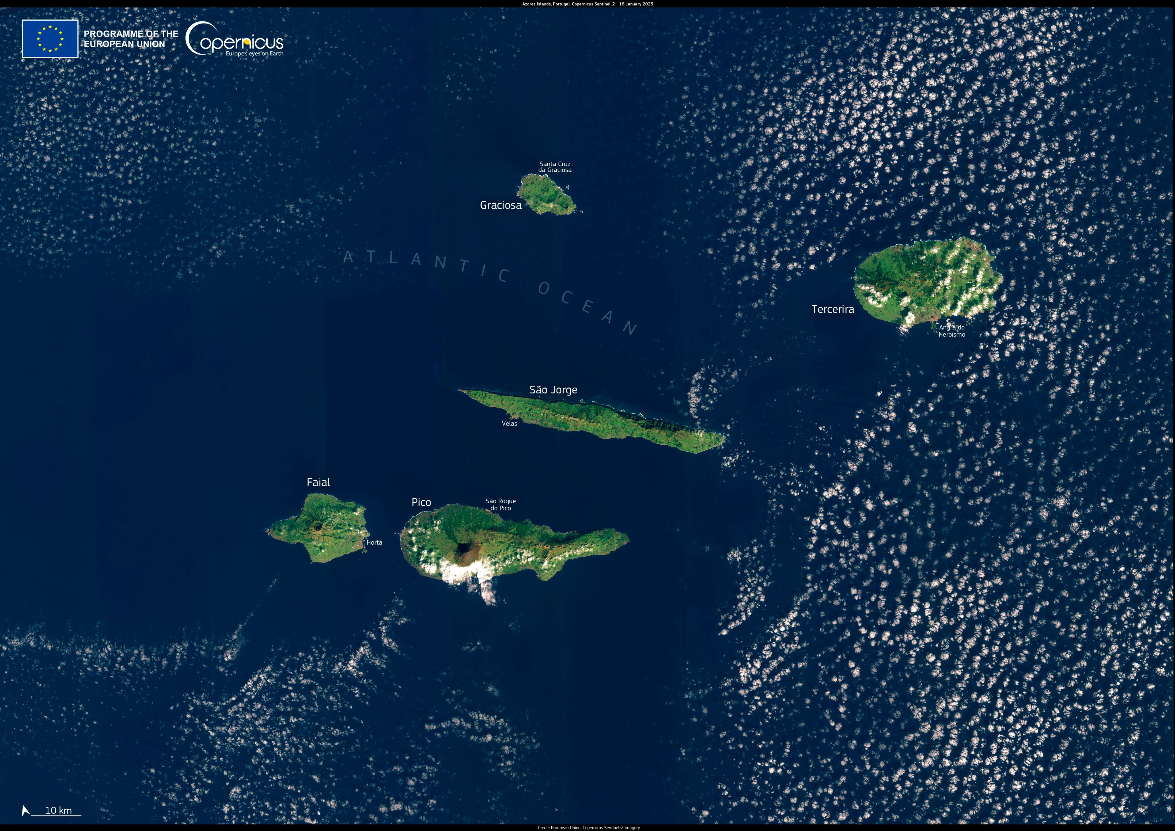
This Sentinel2 image provides a partially cloud-free view of the protected waters south of the islands of São Jorge, Faial, and Pico.
 
He explained that half of the network would be designated as a fully protected area, which means fishing activities are not allowed. In the other half, designated as a highly protected area, only very selective fishing will be allowed.
The nine-island archipelago is an autonomous region roughly 1,500 km (932 miles) west of mainland Portugal and home to unique marine biodiversity.
 

The Azores government chief Jose Manuel Bolieiro said the region was leading by example at national, European and international levels in the management and protection of its waters and "making a significant contribution to Portugal meeting the international targets for the decade".

 Links :

Thursday, October 24, 2024

How seafloor mapping reveals New Zealand’s maritime history

LINZ’s hydrographic survey of Tūranganui-a-Kiwa/Poverty Bay

From Hydro by Adam Greenland, Brad Cooper, Jennifer Coppola, Annette Wilkinson

Like other hydrographic offices, Toitū Te Whenua Land Information New Zealand (LINZ) collects survey data for safety of navigation, producing and maintaining nautical charts and products in accordance with SOLAS Chapter V, Regulation 9.
Finding new and unusual features such as shipwrecks is the icing on the cake.
LINZ’s recent survey of Tūranganui-a-Kiwa/Poverty Bay uncovered two locally known but previously uncharted wrecks, mapping them both in 3D and igniting interest in their stories – their origins, their voyages and their eventual demise.

As the New Zealand Hydrographic Authority, LINZ provides navigational products and services that support safe shipping.
The information underpinning these products is captured through hydrographic surveys that map the seafloor.
This data gives a detailed view of the seafloor and can be used to obtain a better picture of how the marine environment has changed with time, weather and geological events.

New Zealand’s area of charting responsibility is vast for the size of the country, covering an area comparable to Europe and North Africa.
Not only does it cover New Zealand waters, but also parts of Antarctica and the South-West Pacific.
As an island nation, New Zealand relies on shipping for many of its imports and exports.
Seabed mapping provides the data needed to update nautical charts and to meet LINZ’s obligations to make navigating the waters around New Zealand, the South-West Pacific and the Ross Sea region of Antarctica safer.

Risk assessment and HYPLAN


New Zealand’s hydrographic survey plan, HYPLAN, was based on a novel risk assessment methodology completed in 2016.
The risk assessment considers AIS vessel traffic data, the locations of environmentally and culturally sensitive sites, hazards such as reefs and the age of the survey data currently on the chart.
The resulting heat maps of navigation risk help LINZ to determine priority areas for surveys, sometimes replacing data collected during Captain James Cook’s voyages more than 200 years ago!

Partnering to benefit tangata whenua and conservation

LINZ aims to ‘collect data once, use many times’, and proactively engages with local councils, other national agencies such as the Department of Conservation (DOC), and tangata whenua of Aotearoa (people of the land), who represent New Zealand’s Māori population.
Partnering with others allows New Zealand to optimize funding and collect datasets that can be used for many purposes.
In previous partnerships, LINZ extended the survey remit to cover areas for marine science research and collected additional data such as seabed samples and even seabird sightings.


Figure 1: New Zealand’s charting responsibilities are highlighted, and its exclusive economic zone (EEZ) outlined in black.

For the Tūranganui-a-Kiwa/Poverty Bay survey, local iwi (tribal groups) were interested in data from the coastal area to the south of Young Nicks Head/Te Kurī.
DOC also wanted Te Tapuwae o Rongokako Marine Reserve (ten nautical miles to the north) to be surveyed.
The reserve has never been mapped in such detail and the information discovered will help to care for this marine taonga (treasure).
Adding additional areas to be surveyed on top of the planned extent presents challenges; however, the benefits to iwi and for marine management and the protection of ocean biodiversity is of great importance to LINZ.

Approaches to Gisborne survey

Tūranganui-a-Kiwa/Poverty Bay is located in the Gisborne region, on the north-eastern coast of New Zealand’s North Island.
In New Zealand, many place and feature names are made up of an English name and an original te Reo Māori name.
Tūranganui-a-Kiwa is the Māori name for the bay, describing the long-standing or waiting place of Kiwa of the Horouta or Tākitimu waka (boat).
Poverty Bay was named by Captain Cook on his voyage around New Zealand because he was not enamoured with the district.
He wrote on 11 October 1769: “We weighed and stood out of the Bay, which I have named Poverty Bay, because it afforded us no one thing we wanted.” A large portion of the bay had not been mapped since the Royal NZ Navy’s singlebeam survey in the early 1950s.
Since then, technology has advanced hugely, revealing what lies beneath the surface in greater resolution than ever before.


Discovery Marine Limited (DML), based in Tauranga, New Zealand, was contracted by LINZ to complete the survey.
The survey covered two areas: the Tūranganui-a-Kiwa/Poverty Bay survey area was 88km2 and completed to LINZ-1 standard; the Te Tapuwae o Rongokako Marine Reserve was 21km2 and completed to LINZ-2 standard (see Figure 2).


Figure 2: Tūranganui-a-Kiwa/Poverty Bay survey area, including Te Tapuwae o Rongokako Marine Reserve.
Two previously uncharted wrecks (Korua and Star of Canada) were mapped in detail during the survey.


The survey was done in two phases to take advantage of weather windows and optimize vessel use.
The offshore phase was completed in November 2022 with a 23m (length), 6.4 m (beam) aluminium monohull vessel.
The inshore phase was conducted between October and December 2023 using the 7.7m (length), 2.49m (beam) Senator 770.


The multibeam (MBES) used for both phases of the survey was the single-head Teledyne Reson SeaBat T50-R.
Other key equipment included the Applanix POS MV WaveMaster II, AML Oceanographic Micro X sound velocity sensor and AML-3 LGR sound velocity and temperature profiler.
Positioning was done using Trimble’s Fugro Marinestar.
The MBES was operated at a frequency of 300kHz for the duration of the survey.

Besides the bathymetry required for updating nautical charts, other datasets such as acoustic backscatter and water column data were simultaneously acquired from the MBES system.
To help reduce the large data volumes associated with water column data, two operating modes were adopted: ‘normal operation’ mode offered higher compression, and ‘area of interest’ mode offered lower compression with higher resolution over suspected freshwater springs and reef areas.


In all, 8.1TB of raw data was collected, which besides updating charts can be used for habitat and sediment deposition mapping, flood planning and 3D visualization of shipwrecks.
Shipwrecks rediscovered during survey

Star of Canada


The Tūranganui-a-Kiwa/Poverty Bay survey mapped two previously uncharted shipwrecks: the Star of Canada and the Korua.
While the local community was aware of these wrecks, they have never been mapped to such fine detail (Figure 3).

The 7,280-ton steamer Star of Canada first voyaged to New Zealand in 1910.
For the next two years, it regularly travelled from Australia and New Zealand to England, carrying chilled and frozen meat and other produce.
On 23 June 1912, a southerly squall blew the vessel onto Kaiti Beach, where it struck rocks and began taking on water.
The next couple of days was spent salvaging as much of the cargo as possible, including mutton, oats, wool and antimony.
Fortunately, no souls were lost.

A heavy swell finally broke her hull, and she was abandoned to the underwriters.
The two-storied wheelhouse and captain’s cabin, plus part of the deck superstructure, was purchased by a local engineer and brought ashore.
In 1983, the Star of Canada was bequeathed to the citizens of Gisborne and, in 1985, the wheelhouse was moved with great pomp (in a festival that coincided with high tide) to its current location.


The superstructure now sits along the Tūranganui River in Gisborne and houses the Tairāwhiti Museum.
The captain’s cabin largely contains the original fixtures and fittings and many artefacts that were salvaged from the ship.

Figure 3: 3D image of the Star of Canada wreck.

Korua

The second wreck found during the survey was the remains of the dredge Korua (Figure 4), off Young Nicks Head/Te Kurī.
This vessel was used to dredge nearby Napier and Gisborne harbours in the 1930s.
She played a significant role in the establishment of the Port of Gisborne.
At the time, several harbour schemes had been proposed for Gisborne.
A breakwater groyne was constructed in the early 1900s and the river diversion wall was built in the 1920s to reroute the Tūranganui River.
Between 1925 and 1931, Korua’s role was to excavate 1,920,000 tons of spoil.
Today, the Port of Gisborne is critical for primary industry exports such as logs, kiwifruit and squash.


Korua was scuttled in 1940 when it was no longer of use.
Interestingly, the 1953 navy survey did detect a shoal sounding (three fathoms, two feet, roughly equal to 6.1m) in the location of the Korua wreck (Figure 5).
With today’s technology, the wreck can be mapped in much higher resolution.
The least depth over the wreck is now 11m, which suggests the wreck may have toppled over in the 70 years since it was last detected by an echosounder.

Figure 4: The remains of the Korua shipwreck scattered on the seafloor.
LINZ open data services

Data captured in the Gisborne hydrographic survey, including details of the two wrecks, will be used to update nautical charts of the area and help to make navigation safer.
The upcoming LINZ 3D Coastal Mapping programme will map up to 40% of New Zealand’s coastline and could also reveal previously unknown features such as shipwrecks.

In keeping with LINZ’s goal to ‘collect once, use many times’, LINZ’s open data policy means that all data it collects is available for anyone to use under Creative Commons Attribution 4.0 International licence (CC-BY 4.0).
Bathymetric surfaces in the form of two-metre depth grid models can be downloaded from the LINZ Data Service (https://data.linz.govt.nz/).
Other data is available upon request by emailing hydro@linz.govt.nz.

Figure 5: A 1953 survey detected a shoal sounding (three fathoms, two feet) in the location of the Korua shipwreck.
The figure shows the historic sounding sheet superimposed on the high-resolution multibeam depth surface.

Conclusion

LINZ surveys the waters of its charting area as part of its international obligations and determines survey extents based on hydrographic risk assessments.
The data needs of local stakeholders and other government agencies are considered in LINZ’s hydrographic survey plans, which acknowledges the wide use of hydrographic data.
Among the rich dataset of the Gisborne survey, two known wrecks were mapped and charted for the first time, improving navigational safety in the area.
Each wreck has its own story, but one shows the value of increased coverage with MBES compared to an old SBES survey that detected an anomaly but did not identify the wreck.
It is also noted that features such as wrecks make for a very engaging way to get the public interested in hydrographic surveying.

LINZ is currently updating its risk assessment, which will help inform the future HYPLAN.
Who knows what wrecks will be uncovered next…
For more information, see here.

Figure 6: Black and white image of the dredge, Korua.
(Image courtesy: Stan Vincent, Tairāwhiti Museum)
 
Links :

Wednesday, October 23, 2024

Protecting ships from cyber terrorism

 
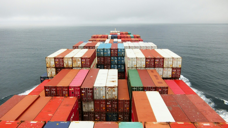
Image via Unsplash
 
From SecurityMag by Ilan Barda 

The investigation into Baltimore’s Francis Scott Key Bridge collapse has only just begun, but we’ve already seen news reports containing an unclassified memo from the Cybersecurity and Infrastructure Security Agency (CISA) and comments from the Department of Homeland Security concerning the cause.
Maryland Governor, Wes Moore, said he could confirm that "The crew notified authorities of a power issue," adding that the ship had lost power before smashing into one of the columns supporting the bridge.
At this time, there is no evidence that the incident was anything more than a tragic accident, but the involvement of these U.S. government agencies indicates concerns of a cyberattack.

Those concerns are highly warranted.
For some time, maritime cybersecurity has been top of mind for regional, national and global policymakers.
In February, the Biden administration issued an executive order to bolster and safeguard critical maritime infrastructure across the United States.
Other countries and regions are on alert as well.
NIS2, the updated Directive from the European Union slated to go into effect later this year, also addresses maritime cybersecurity.
The International Maritime Organization’s (IMO) cybersecurity guidelines encourage shipping companies and vessel operators to address cybersecurity risks and implement measures to protect their assets, as do frameworks and guidelines from additional regulatory bodies.

Vulnerable maritime systems

The numerous operational technologies (OT) on seafaring vessels have kept pace with digital transformations in other industries.
Once powered solely by onboard fuel and propelled by engines, modern ships are hybrids, utilizing a combination of solar energy and fossil fuels in concert with a variety of smart engines.
Modern propulsion systems now employ multiple connected technologies that reduce fluid friction and optimize performance.
But these and other technologies can be cyber-compromised.

There are plenty of onboard systems to attack.
Hackers are known to intercept satellite communications used extensively by ships at sea.
They can also spoof or jam GPS systems, manipulate the automatic ID system (AIS), steal vital data, or inject malware or ransomware into any number of onboard systems via infected devices or files.
Such attacks can throw a ship off course.
When combined with a compromised propulsion system, the consequences can be horrific.

Attacks on operating vessels aren’t the only vulnerabilities that shippers need to be concerned about.
Risk starts early in the shipbuilding process.
The long, complicated process of shipbuilding introduces a complex supply chain, where numerous parts and software products originating from multiple locations and a variety of international vendors become part of the ship’s essence.
During manufacture, ship components may be compromised with latent malware, as threat actors patiently wait for the right future moment to interfere with communication or navigation systems, or to exploit a remote-access backdoor to take control of the ship.

Ports and offshore facilities are also major elements of the maritime ecosystem, and they expose a collection of additional attack surfaces.
Equipment and systems operating on loading docks and even oil rigs are inviting targets.
These communicate with ships and can unknowingly share malware.
Equipment and systems — from Chinese-made cranes to container-stacking machinery to drilling mechanisms — are in the hacker’s sights.

Consequences of maritime cyberattacks

Regardless of whether this disruptive, deadly crash was an unfortunate accident or the result of a repugnant cyber attack, it highlights the potential consequences of cyber terrorism on the maritime industry.
Contacting just one column of the 1.6-mile-long bridge, the ship was able to bring large portions crashing into the water and tragically end the lives of six construction workers.

The economic damage is extensive.
The Port of Baltimore — one of the busiest car import/export points in the US and home to some of the largest retailer distribution centers like FedEx, Amazon, and Home Depot — is shut down until further notice.
Many of the 15,000 employees who work directly for the Port and 140,000 other employees supported by the Port’s ecosystem are out of work.

Meanwhile, the Key Bridge, a vital road transportation route, is shut down indefinitely, forcing 30,000 daily commuters to find alternate routes.

Shielding the maritime industry


Safeguarding maritime vessels and infrastructure against cyberattacks is complicated, especially considering the deployment of Chinese-manufactured cranes throughout US seaports.
Maritime cybersecurity demands a multifaceted approach rooted in robust cybersecurity measures and continuous vigilance.
A comprehensive prevention program encompassing accurate risk management, stringent access controls, continuous threat detection, and incident response planning is called for immediately.

By prioritizing cybersecurity measures in the face of evolving threats, maritime organizations can fortify their resilience against cyberattacks, ensuring the safety and integrity of their operations and to the public at large.

While this particular incident may turn out to be a very unfortunate accident, the next one might come as a result of a cyber incident.
Let’s not wait.

Links :

Tuesday, October 22, 2024

Social media influencers’ bad behavior with marine wildlife is risky for animals, too (commentary)

A great white shark.
Image by Pterantula (Terry Goss) via Wikimedia Commons (CC BY-SA 3.0).


Social media accounts which showcase close encounters with marine wildlife — from whales to white sharks and manta rays — have become common and popular.
A distinctive feature of these is the presence of people in the images, where the focus is frequently on the individual near – or sometimes in direct contact with – the species: the main subject is not the animal itself but the human interacting with it, which puts both people and wildlife at risk.
“In these experiences, what many of us often seek – a unique connection with a species different from our own – overlooks a fundamental principle: marine wildlife does not need our friendship, but rather our protection,” a new op-ed argues.

Many of us have likely come across that viral video on social media – a young woman touching the back of a large, possibly pregnant, great white shark, swimming alongside it for about 10 seconds.
The woman in question, Ocean Ramsey, has two million followers on Instagram and has been capturing attention by demonstrating that when approached in a certain way, sharks are not a threat to humans.

But this is just one of many social accounts that showcase close encounters with marine wildlife.
Seeing images of people swimming alongside giant sperm whales resting vertically with their calves, floating among groups of nurse sharks, or stroking manta rays has become more common than ever before.
While there is an initial fascination in witnessing a human swim peacefully next to what many consider their worst nightmare, or treating a giant like a pet, it raises important questions about the real purpose of such interactions.
Moreover, can we be certain that encouraging this shift from fear to confidence is having a net positive effect on the protection of both species involved – humans and wildlife?

In a world where over 60% of the global population uses social media, several studies have demonstrated that these platforms can be powerful tools for conservation communication, helping to inform, educate, and drive engagement.
Accounts like those of Oceana (with three million followers) and Ocean Conservancy (with over 460,000 followers), for instance, share daily sea life images, promoting awareness campaigns, interviews with experts and communities, and encouraging concrete conservation actions.
 
Screenshot of video posted to Instagram by shark tourism operator Jim Abernethy, where a diver touches a shark, September 6, 2024.

However, marine conservation programs are not the only ones publishing marine wildlife content on these platforms.
Many tourism operators and commercial brands also capitalize on this trend by offering unforgettable wildlife encounters and products related to marine life.
Finally, there is a grey area occupied by influencers – individuals with large online followings who promote their personal brand while advocating for ocean conservation.
Often coming from backgrounds in marine biology, sports or related fields, these influencers sometimes offer workshops and courses or sell trips that promise controlled interactions and eco-sustainable travel.
They also frequently support themselves financially through secondary commercial activities, endorsing a wide variety of products, from scuba diving equipment to sunscreen brands.

The distinctive feature of these types of influencers is their presence in the images, where the focus is frequently on the individual near – or sometimes in direct contact with – the species.
Thus, the main subject is not the wild animal itself but the human interacting with it.
Certainly, this anthropocentric perspective is not new, as images of humans with wildlife have been captured since the very inception of photography.

However, the advent of platforms like Instagram, Facebook, and TikTok has greatly facilitated the global sharing of such content.
With their large following, influencers could play a significant role in raising awareness among a broad audience about issues affecting certain species (e.g., overfishing and plastic pollution), and in reshaping the public perception of animals like sharks, which are often misunderstood and demonized.
However, there is a risk that, in some cases, oversimplification of concepts – even with good intentions – can lead to misinterpretation.
For example, certain animal behaviors may be anthropomorphized in an attempt to make them more relatable to human emotions, potentially underestimating the complexity of the species.

Due to their reliance on capturing extraordinary moments to sustain their livelihoods, influencers may often disregard basic safety guidelines.
This issue was highlighted in a 2021 study, which was based on interviews with tour operators offering wildlife experiences with humpback whales in Niue, New Zealand fur seals, and bull sharks in Fiji.
The study found that, even when observation guidelines were clearly established and well-regulated, influencers and photographers frequently ignored basic safety rules to achieve the “perfect shot,” posing significant risks to the safety of both operators and other participants.

The spread of aesthetically pleasing images of marine species, along with the implicit promotion of certain types of interactions, is also driving demand for such experiences among followers.
A striking example of social media’s impact occurred in Mexico’s Sea of Cortez in 2021, where a pod of orcas was filmed over several days by local influencers.
Dramatic footage, including scenes of a dolphin being tossed into the air during a hunt, went viral, sparking increased interest in the species in this region.
 
Screenshot of social media post by shark biologist Dr.
David Shiffman, where a diver touches a shark, 2019.


While tourism involving cetaceans like sperm whales is regulated under NOM-131-SEMARNAT-2010 in Mexico, there is currently no clear management plan for orcas, and guidelines for appropriate behavior around them remain lacking.
A quick Google search for “swimming with orcas in the Sea of Cortez” reveals numerous companies now offering such experiences.
Although these operators claim to adhere to animal welfare guidelines, a look at tourist photos on Instagram often shows safety distances being ignored, with people too close to orcas, even during hunting activities.

This situation not only puts swimmers at risk but also causes significant energy expenditure for the animals.
In their natural environment, orcas, like other marine species, carefully manage their energy reserves, balancing vital activities such as hunting and nurturing young.
The presence of boats and swimmers disrupts this delicate balance, diverting the animals’ attention from essential tasks to avoid perceived threats.
Over time, these disturbances could have serious cascading effects on their health and survival, particularly if they become frequent.
Despite some coverage by local media, no safety measures appear to have been implemented yet in response to these growing concerns.

The consequences of close interactions with marine wildlife are complex and should not be underestimated.
While scientists continue to struggle with producing concrete evidence of their impact, influencers who promote such interactions often defend their actions by claiming that, if the animals were truly affected, they would simply move away.
However, in a society where we frequently misinterpret the consent of our own species, can we really assume the right to fully understand the reactions of other species?

Meanwhile, the pressure from mass tourism and the desire for close encounters with wildlife continues to grow.
This trend has led to scenes of inappropriate tourism practices, such as the recent crowds observed around whale sharks in the Maldives.
In some cases, these interactions have resulted in accidents, highlighting the risks posed by inadequate management.
For instance, on Australia’s Gold Coast, a whale likely irritated by the group’s proximity threw a tour guide from the water with its tail.
Similarly, a group of divers in the Maldives was attacked by a tiger shark during a dive – a practice that often involves shark feeding.
 
 
This crowd that surrounds a whale shark is likely one result of viral social media posts featuring contact with marine wildlife.
Screenshot of a video posted to Instagram by divingmaldive in June, 2024.


In light of such events, the precautionary principle becomes crucial.
As Burns, MacBeth, and Moore (2011) assert: “If a wildlife tourism action carries a suspected risk of causing harm to animals or their habitat, and there is no scientific consensus that the action is safe, the burden of proof lies with those proposing the action to demonstrate that it is not harmful.”

Before the rise of social media, many of us grew up watching environmentalists and nature enthusiasts like Steve Irwin, who showcased interactions with fascinating and often formidable wild animals.
However, history has demonstrated that some of these figures, despite their expertise, underestimated the real dangers of close encounters with wildlife – sometimes at the cost of their own lives, as in the tragic case of Timothy Treadwell.

Moreover, while in the past we were simply awestruck in front of our televisions, today, with the advent of mass tourism and the proliferation of nature experiences, everyone wants to emulate what we see from our beloved figures.
Yet, in these experiences, what many of us often seek – a unique connection with a species different from our own – overlooks a fundamental principle: marine wildlife does not need our friendship, but rather our protection.

Monday, October 21, 2024

Inside the elaborate scheme to transport a Chinese power plant to Russia’s Arctic undetected


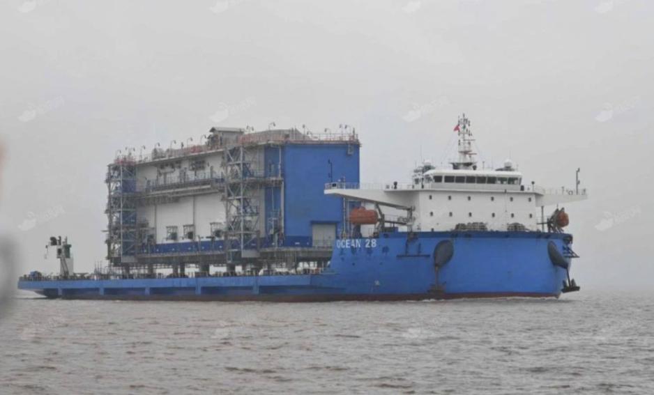
Heavy lift vessel Ocean 28 departing from Zhangjiagang with a substation module
on September 23, 2024. 
(Source: HNN)

From High North News by Malte Humpert

In a desperate attempt to salvage Russia’s largest liquefied natural gas project a small fleet of Chinese cargo vessels has set sail for the Arctic.
Aboard is a massive power plant for Novatek’s Arctic LNG 2 project, assembled at China’s Wison New Energies for the past two years.
With only weeks left before winter sea ice will make the route impassible the delivery is a race against time and against Western sanctions.


It is the summer of 2022, months after the full scale invasion of Ukraine, and Russia's largest producer of liquefied natural gas finds itself in a tight spot.

The future of Novatek’s flagship gas project looks increasingly uncertain following the departure of Western technology partners.

American company Baker Hughes has only delivered four highly sophisticated gas turbines, Novatek needs almost two dozen.
Think massive airplane engines found on a Boeing 777.

Novatek succeeds in redesigning the first production line to run on only four Western turbines, but the picture is much bleaker for the second production line under construction at that time.

Without the turbines the project is effectively dead in the Arctic water.

The company turns to its Chinese engineering and construction partner Wison New Energies.
The solution is a massive onshore power plant running on older, less efficient Chinese turbines.

Wison's main construction yard begins construction on the power generation modules in December 2022.

Fast forward to the summer of 2024.
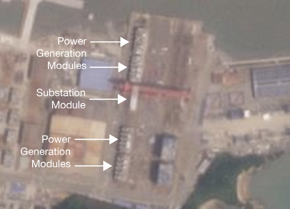
Four power generation modules and one substation, each the size of a midsize apartment complex, have been completed and are awaiting pick up at Wison’s Zhoushan yard.

Now the key question is: How to deliver the large structures to the Arctic without detection.

The U.S.
has been adamant about stopping Russian LNG expansion, including Novatek’s Arctic LNG 2 project.

Thus far Wison has escaped U.S. sanctions.
Earlier during the summer of 2024, when the U.S. sanctioned a neighboring shipyard, Wison quickly recalled a vessel en route to Russia carrying equipment for the Arctic project, possibly for fear of repercussions.

In June 2024 Wison announced it would cease all cooperation with Russia.

But construction on the power generation modules and substation for the onshore power plant seemingly continued.

The first module, the substation, was picked up by a heavy lift vessel in late August 2024, a specialized vessel designed to carry large structures.
Two additional modules, both related to power generation, were loaded less than two weeks later.

What follows is a detailed account of an elaborate scheme to transport elements of the onshore power plant to the Russian Arctic undetected.

The operation includes using a half dozen vessels, unloading and reloading the modules in various Chinese ports to obscure their origin, and renaming as well as repainting vessels mid-voyage to confuse anyone who may be watching.

Novatek and Wison: A Critical Partnership
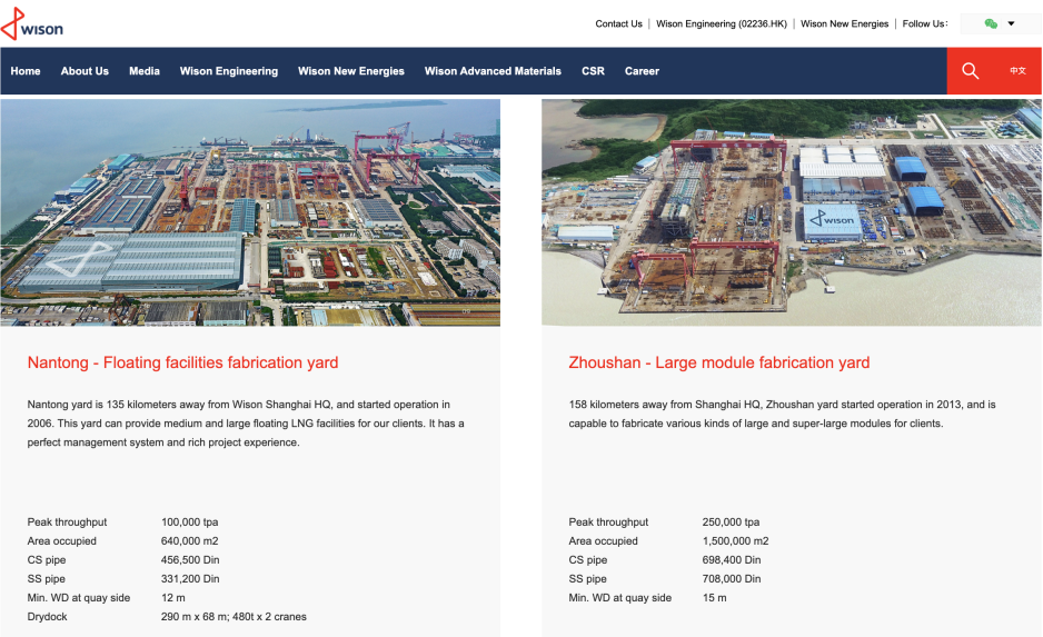
Screenshot of Wison indicating that the Zhoushan yard remains part of the company.
(Source: Wison)


Wison New Energies has been a key partner for Novatek’s Arctic LNG 2 project, manufacturing a dozen modules, more than any other Chinese construction yard contracted for the project.

Between 2021 and 2023 it delivered eight modules forming the core of each production line.
An attempt to transfer the final modules was canceled in July 2024, likely for fear of sanctions.

Wison also announced that it would cease all cooperation with Russia and divest from or sell its Zhoushan construction yard.

However, those steps have apparently not been taken.

“The yard has not been sold yet, and they have not completed the divestment.
The Arctic LNG 2 modules […] have not been transferred yet,” a person familiar with developments at the Zhoushan yard told HNN on condition of anonymity due to the sensitive nature of the subject.

Wison’s website confirms that the Zhousan yard remains part of the company’s assets.

Following Baker Hughes’ exit Novatek turned to Wison to construct an onshore power plant to deliver the massive energy needs to drive the re-designed liquefaction line, now using an electrical drive.

“Due to the departure of Baker Hughes, Wison provided Novatek with a land-based generator solution using Chinese gas turbines,” the source confirms.

Wison constructed five new modules: Four power generation modules, referred to as PGM1 to PGM4, and one substation.
Each module weighing between 5,000 and 7,000 tonnes.

Wison’s Zhoushan yard began working on the onshore power plant (OPP) modules in late 2022.
The gas turbines housed inside the modules are provided by Harbin Guanghan Gas Turbine (HGGT), a manufacturer of gas turbines for power generation.

Without the onshore power plant, the second production line of Arctic LNG 2 can not be commissioned.
 
Five Modules Take Shape at Wison Zhoushan

Throughout 2023 and into 2024 satellite images document the progress Wison makes on the five modules.
By summer of 2024 the modules appear to be near completion.

 
Five modules in one row are visible August 13, 2024 at Wison Zhoushan.
(Source: Planet)

By late summer of 2024 a complex plan had been put into place to transport the modules to the Russian Arctic, the source tells HNN.

The degree to which Wison is directly or indirectly involved in the logistics scheme could not be independently confirmed.
What is clear is that Wison manufactured the modules and allowed for them to be loaded at its Zhoushan facility in recent weeks.

In repeated conversations between Wison New Energy and HNN the company advised that it “has discontinued all ongoing Russian projects, including the delivery of any goods to Arctic LNG2.”

However, Wison did not dispute the factual accuracy of HNN’s investigation.

Instead it advised that “Wison has secured binding assurances from its partners that any Wison modules will not be delivered to Arctic LNG 2, and to the extent those third parties have violated their agreements, Wison will notify these third parties of such breaches and pursue corrective remedies.”

The company reiterated that it “will continue to operate consistently with international policies instituted against Arctic LNG 2.”

A copy of the full statement can be found here.

Picking up the First Module

In mid-August a Chinese heavy lift vessel approached Wison’s Zhoushan yard and over the course of about a week the substation module was carefully maneuvered onto the vessel.

The vessel in question is Ya Qing Hai Yang, Chinese-owned and operated.
The loading operation was completed around August 23, based on a series of satellite images.
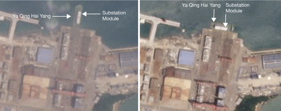
Satellite images taken between August 16 and August 23 show the loading of the substation module onto Ya Qing Hai Yang.
(Source: Planet.com)

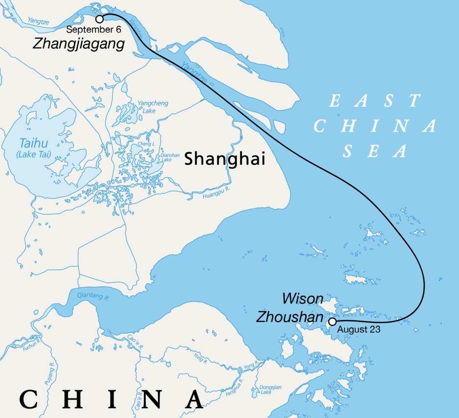
Rather than setting a direct course for the Arctic, Ya Qing Hai Yang carried the substation module around 150 nautical miles to the public port facility at Zhangjiagang Gangxin Heavy Equipment Port Co., where it arrived on or around September 6.

 
Illustration showing the trip by Ya Qing Hai Yang from Wison Zhoushan to Zhangjiagang between August 23 and September 6, 2024.
(Source: HNN)

“Wison is afraid of being sanctioned, so they don't want the module to go directly to Russia, so they have found a new port for transshipment,” the source explains.

By offloading and reloading the module at a public port facility, the shipper may hope to create sufficient “distance” between itself and the delivery of any modules to Russia.

A similar line of argument employed by Singaporean shipping operator Red Box carrying modules to Arctic LNG 2, failed to persuade U.S. officials.
The company had claimed that it was unaware of the specific cargo it was carrying and it was simply a third party service provider.
The company and its two vessels Audax and Pugnax were sanctioned in May 2024.

A series of satellite images shows the offloading of the module, its repositioning at the yard, and subsequent reloading.
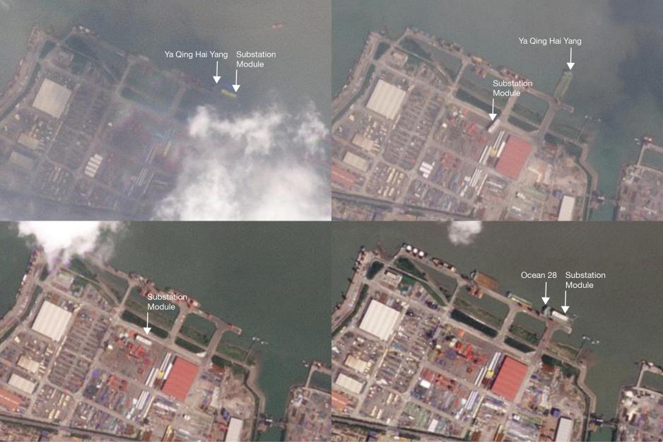
Satellite images show Ya Qing Hai Yang at Zhangjiagang on September 6, the module being unloaded on September 7, the module at the port on September 10, and the module being loaded back onto the same vessel under a different name on September 22.
(Source: Planet.com)

An “East China Sea” Paint Job

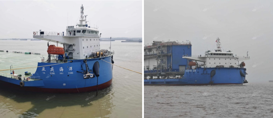
While the substation module remained at the Zhangjiagang port facility, Ya Qing Hai Yang underwent a “maritime magic trick” as one analyst describes it to HNN.

Ya Qing Hai Yang returned to Zhangjiagang as the newly renamed Ocean 28. 


Photos of heavy lift vessel Ya Qing Hai Yang and renamed as Ocean 28.
(Source: HNN)

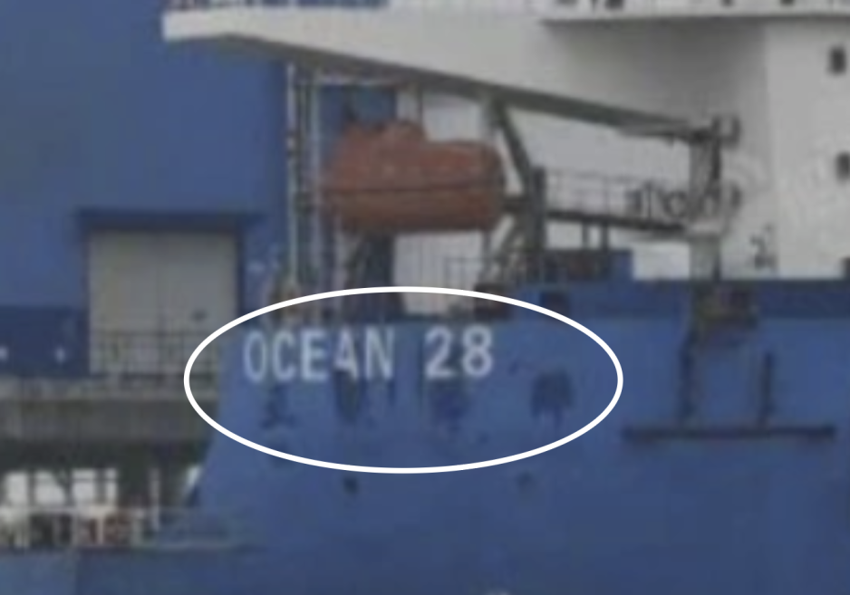
Photos taken about a week apart show in a striking manner the renaming of the vessel, with its original Chinese name and characters painted over and the new name hastily written above, with blue paint patches covering the old name seemingly still wet. 

 
Zoomed-in detail showing the still-wet paint on Ocean 28.
(Source: HNN)


The practice of painting over a vessel’s name to obscure its true identity has become known as a “Bosporus paint job” used by Russian traders in the waters near Istanbul.
In the narrow strait vessels entering or leaving the Black Sea can be easily identified from shore.

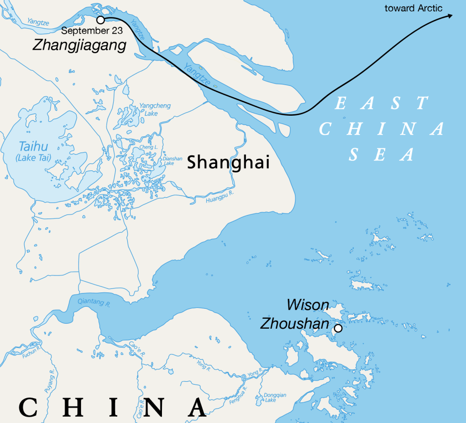
Ocean 28 departed from Zhangjiagang with the substation module on September 23, 2024.
Its Automatic Identification System (AIS) record confirms its departure date and photos show it carrying the module.

In the days that follow the vessel passes through the East China Sea and travels past the Korean Peninsula.
It continues to head north-northeast in the direction of the Bering Strait, where it will take the Northern Sea Route to Arctic LNG 2, sources confirm.

 
Illustration showing the trip by Ocean 28 departing Zhangjiagang on September 23, 2024.
(Source: HNN)

Its AIS currently displays Norway as destination, a common tactic to avoid arousing suspicion previously employed by vessels traveling to Russia.

Unlike regular modules for Arctic LNG 2, which were delivered to an assembly yard called Belokamenka near Murmansk, the onshore power plant elements can be installed directly at the Arctic LNG 2 project.

Satellite images suggest that site preparation work may already be underway.

A Wison document seen by HNN showing possible locations for the onshore power plant aligns with the location on the satellite image. 
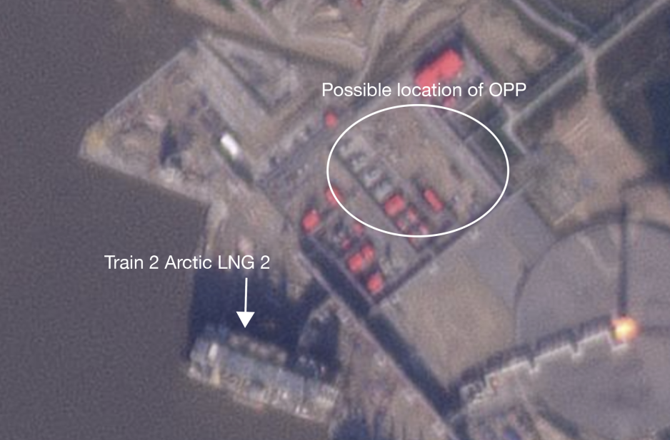
Satellite image from September 11, 2024 showing Train 2 of Arctic LNG 2 and possible location of the onshore power plant.
(Source: Planet.com)

Loading Modules Two and Three

 
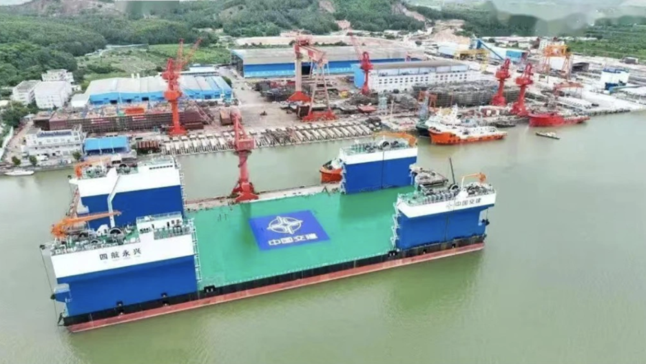
File photo of Si Hang Yong Xing.
(Source: China Classification Society)

A week after the departure of Ya Qing Hai Yang, the next vessel arrived at Wison’s Zhoushan yard.

The non-propelled barge Si Hang Yong Xing first appeared on satellite images on August 31.
The craft is routinely used by Wison to transfer modules between yards.

Over the course of 9 days two power generation modules are loaded onto Si Hang Yong Xing. 
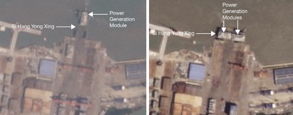
Satellite images from August 31 and September 8 showing the loading of two power generation modules, PGM-001 and PGM-002, onto Si Hang Yong Xing.
(Source: Planet.com)

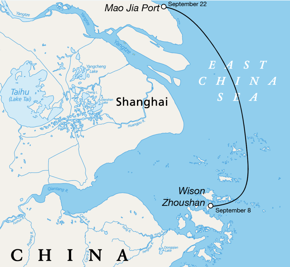
The barge subsequently traveled from Zhoushan to Mao Jia Port around 175 nautical miles away.

 
Illustration showing the trip by Si Hang Yong Xing departing Wison Zhousan on September 8, 2024 to Mao Jia Port.
(Source: HNN)


There it was joined by already-sanctioned heavy lift vessel Nan Feng Zhi Xing.
Over the course of four days one of the power generation modules is reloaded.

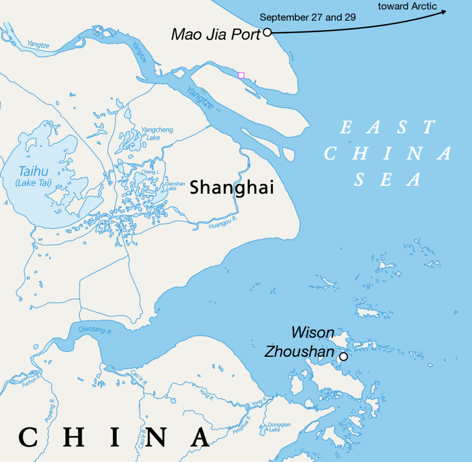
A satellite image taken just before its departure on September 27 shows one power generation module aboard Nan Feng Zhi Xing with the other remaining on Si Hang Yong Xing.

Nan Feng Zhi Xing departed midday on September 27 traveling on the same course as Ocean 28 a week earlier.
Its AIS currently displays Vladivostok as a destination, possibly a diversionary tactic.

Nan Feng Zhi Xing was immediately replaced at the dock by Hunter Star, another previously sanctioned heavy lift vessel.
AIS tracks confirm its departure and arrival times.

The transfer of the second power generation module onto Hunter Star is completed in around 36 hours and the vessel departed on September 29, following Nan Feng Zhi Xing’s course.

Again, satellite imagery confirms the transfer of the module. 
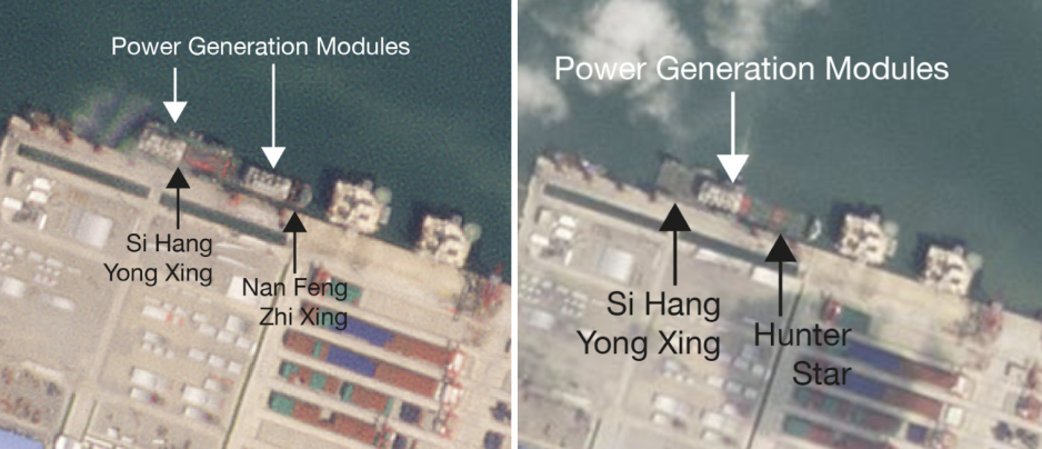
Satellite image showing the transfer of the second and third power generation module in progress from Si Hang Yong Xing to Nan Feng Zhi Xing and Hunter Star on September 27 and 28, 2024.
(Source: Planet.com)

Modules Four and Five Still at Zhoushan

Illustration showing the trip by Nan Feng Zhi Xing and Hunter Star after departing from Mao Jia Port on September 27 and September 29, 2024.
(Source: HNN)


Modules four and five remain at the Zhoushan yard as of September 30, 2024.

With the summer shipping season coming to an end in the Arctic, there may not be sufficient time to ship the final two power generation modules before sea ice blocks the northern shipping lane.

Arctic LNG 2 may be able to start up the second production line at half capacity running on only two power generation units, the source confirms.

How will the U.S. react?

Over the past 18 months or so the U.S. has been adamant about interdicting the completion of Arctic LNG 2, in an effort to deprive Russia of the revenue associated with the export of LNG.

Given the U.S.’ continued resolve to stop the Arctic LNG 2 it appears likely that this latest attempt to deliver equipment to the project will result in swift action with consequences for Wison, the shipper, or both.

“Attempts to operationalize the sanctioned Arctic LNG 2 project will continue to be met with a swift U.S. government response.
Collectively, our actions continue to restrict Russia’s ability to bring the ALNG2 project fully online, said Assistant Secretary Geoffrey R.
Pyatt just three weeks ago.

In the process the Departments of State and the Treasury have announced several rounds of sanctions targeting shipping companies, suppliers, and at least one Chinese construction yard – Penglai Jutal Offshore Engineering (PJOE) – supplying modules to Arctic LNG 2.

International sanctions law is complex.
At what point does an attempted delivery of sanctioned technology to a blocked project constitute a violation of sanctions?

The three Chinese heavy lift vessels Ocean 28, Nan Feng Zhi Xing, and Hunter Star are weeks away from delivering their problematic cargo to Russian soil. 
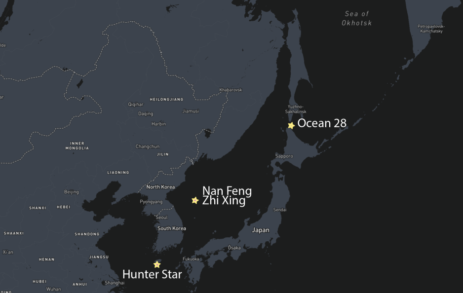
Map showing progress of Ocean 28, Nan Feng Zhi Xing, and Hunter Star en route to the Arctic.
(Source: Shipatlas)


Could the modules still be recalled in an effort to avoid repercussions?
And who is ultimately legally responsible for their loading?
Again, Wison denies any direct involvement and instead points to third parties.

The stakes for Wison New Energies are arguably much higher than for minor shipping companies or suppliers only doing business within China, which limits the impact of sanctions on their operations.

Wison recently signed a $1bn deal with Malaysia's Genting to construct a 1.2m tonnes per annum FLNG facility in West Papua, Indonesia.
It also works with Italian energy company ENI on the fabrication of topside modules for a Congo-bound floating LNG unit.

Just last week Wison and Chart Industries, a U.S. provider of liquefaction technology signed a strategic frame agreement to combine their expertise in the LNG industry.
Will Wison’s close cooperation with Western companies offer it protection from potential sanctions?

One LNG analyst HNN spoke to aptly concluded: “Wison New Energies is on the rise.
How did they think they could play around with sanctions.”

Links :

Sunday, October 20, 2024

EmiratesTeamNZ winners of the Louis Vuitton America's Cup 3 times in a row

The three-peat is complete!
ETNZ deliver a Mediterranean Master Class