A group of geologists say they've enough evidence to confirm the existence of a new continent.
Writing in the journal of the Geological Society of America, the group named the eighth continent "Zealandia."
Writing in the journal of the Geological Society of America, the group named the eighth continent "Zealandia."
Zealandia has been written off for decades “as
an amalgam of continental fragments and slivers” and ocean crust, but
now researchers say the land mass meets all the definitions of a
continent.
From Washington Post by Avi Selk
It's a vast, strange land; its canyons and mountain ranges almost entirely unexplored, its creatures like something out of myth.

Linz nautical maps overlayed on Google Maps imagery with the GeoGarage platform
From what we know, it's beautiful — stretching more than a thousand miles from Savage Seamount across Three Kings Ridge, past swamp forests and volcanoes to the southern slopes.
Pigeons feed on cabbage trees in Zealandia, whales have beaks, and peanut worms crawl above light-less abysses.
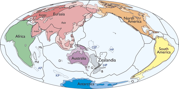
Simplified map of Earth’s tectonic plates and continents, including Zealandia.
Continental shelf areas shown in pale colors.
Large igneous province (LIP) submarine plateaus shown by blue dashed lines: AP—Agulhas Plateau; KP—Kerguelen Plateau; OJP—Ontong Java Plateau; MP—Manihiki Plateau; HP—Hikurangi Plateau.
Selected microcontinents and continental fragments shown by black dotted lines: Md—Madagascar; Mt—Mauritia; D—Gulden Draak; T—East Tasman; G—Gilbert; B—Bollons; O—South Orkney. Hammer equal area projection.
In the last fraction of its long history, a relatively small band of humans has settled Zealandia's greatest mountain peaks, which they call the islands of New Zealand.
This place exists, though most of the 2 million square miles lie beneath the Pacific Ocean.
That shouldn't prejudice us against its significance, scientists argue in a paper that calls Zealandia “Earth's hidden continent.”

“The large and the obvious in natural science can be overlooked,” the researchers said in a newly published study in the Geological Society of America's journal.
As measured by human landmarks, Zealandia encompasses New Zealand and the island of New Caledonia about 1,500 miles to the north.
It stretches beyond both and is two-thirds the size of Australia.
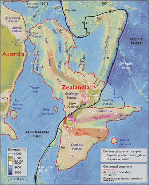
Spatial limits of Zealandia. Base map from Stagpoole (2002) based on data from Smith and Sandwell (1997).
Continental basement samples from Suggate et al. (1978), Beggs et al. (1990), Tulloch et al. (1991, 2009), Gamble et al. (1993), McDougall et al. (1994), and Mortimer et al. (1997, 1998, 2006, 2008a, 2008b, 2015).
NC—New Caledonia; WTP—West Torres Plateau; CT—Cato Trough; Cf—Chesterfield Islands; L—Lord Howe Island; N—Norfolk Island; K—Kermadec Islands; Ch—Chatham Islands; B—Bounty Islands; An—Antipodes Islands; Au—Auckland Islands; Ca—Campbell Island.
Mercator projection.
It would have been immediately recognized as a continent, the researchers argue, if Earth's peaks and valleys “had first been mapped in the same way as those of Mars and Venus” — with no pesky water to obscure the truth of rocks.
“If we could pull the plug on the oceans it would be clear to everyone we have mountain chains and a big high-standing continent above the ocean crust,” lead author Nick Mortimer, a New Zealand government geologist, told Reuters.
Instead, the researchers say, Zealandia has been written off for decades “as an amalgam of continental fragments and slivers”: the wreckage of an ancient supercontinent, Gondwana, which disintegrated when dinosaurs walked the Earth.
We know Gondwana's orphaned survivors as Africa, South America, Australia and Antarctica.

Present day map of CRUST1.0 crustal thickness (Laske et al., 2013) showing the dispersed Gondwana continents of Australia, Zealandia, East and West Antarctica, and South America.
Note thin continental crust in vicinity of Mesozoic arc.
M—Marion Plateau; R—Ross Sea; W—Weddell Sea; F—Falkland-Malvinas Plateau. LIP abbreviations: KP—Kerguelen Plateau; OJP—Ontong Java Plateau; MP—Manihiki Plateau; HP—Hikurangi Plateau.
Thick coastlines in Antarctica are isostatically corrected ice-free coastlines (Jamieson et al., 2014).
Orthographic projection.
If Mortimer and his team have their way, Zealandia would be added to that list.

Zealandia as part of the former Gondwana supercontinent.
Upper panel shows Mesozoic orogen convergent margin that was active until ca. 105 Ma.
Lower panel shows pre-breakup intracontinental extension of Zealandia and West Antarctica from 105 to 85 Ma; seafloor spreading subsequently split Gondwana into its present-day constituent continents (Fig. 3).
Orthographic projections with East Antarctica fixed. From Mortimer and Campbell (2014).
“The accuracy and precision of seafloor mapping have improved greatly over the past decades,” the researchers say. They say Zealandia meets all the definitions of a continent: a huge, coherent mass that sits above and is distinct from the ocean crust.
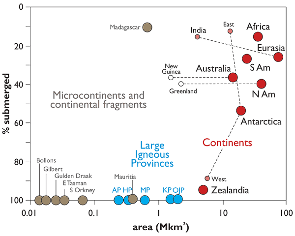
Areas and submergence of all of Earth’s geological continents (red symbols) along with microcontinents (brown symbols) and intraoceanic large igneous provinces (LIPs, blue symbols) shown in Figures 1 and 2.
Note x-axis is log scale.
Data mainly after Cogley (1984) except Zealandia data from Mortimer and Campbell (2014); microcontinents after Gaina et al. (2003) and Torsvik et al. (2013).
Emergent land area for Antarctica is the isostatically-corrected ice-free bedrock surface from Jamieson et al. (2014).
New Guinea and Greenland are arbitrarily given the same submergence value as their parent continents.
AP—Agulhas Plateau; KP—Kerguelen Plateau; OJP—Ontong Java Plateau; MP—Manihiki Plateau; HP—Hikurangi Plateau; N Am—North America; S Am—South America.
Zealandia has all the right rocks. It has “interconnected and throughgoing geological provinces,” the researchers say.
Calling it what it is, the scientists say, would mean “much more than just an extra name on a list.”
It would help us understand the earth beneath our feet — and the parts of it that are not — by exposing a continent unlike any other to more research.
And yet, notes BBC News, “there is in fact no scientific body that formally recognises continents.”
That means Zealandia will become a continent only if members of its minority population — human beings — decide to call it one.
Links :
- National Geographic : 'Lost Continent' Hidden Underneath New Zealand?
- The Inquistr : Is Zealandia A Continent? Scientists See It As One, But Not Everyone Agrees
- Nature : Geologists spy an eighth continent: Zealandia
No comments:
Post a Comment