Saturday, September 20, 2025

Azores, Terceira and Graciosa (1849)

published by UKHO (1849)
 “Map reproduction courtesy of the Norman B. Leventhal Map & Education Center
at the Boston Public Library”
 
Current ENC from IHPT (Hydrographic Office of Portugal)
on the GeoGarage platform
 

Friday, September 19, 2025

Op-ed: Addressing the legal and navigational deficit in the new Arctic


The Thamesborg aground in Franklin Strait, Nunavut.
Canadian Coast Guard photo.


From Workboat by Michelle Levano 

Sea ice retreat is creating new economic opportunities for shipping, but exposes a critical safety deficit.
Rooted in inadequate hydrographic charting and contentious legal framework through the United Nations Convention on the Law of the Sea (UNCLOS), and the supplementary, International Maritime Organization (IMO) Polar Code, vessels are operating at an elevated risk.

There is a direct link between outdated nautical charts and maritime accidents in this challenging environment.
Despite promising technological advancements and collaborations, the pace of progress is still glacial compared to the escalated demands on increased maritime traffic in the area.
The dangerous interplay of legal ambiguity, technological gaps, and geopolitical competition collectively jeopardizes the maritime safety of the fragile Arctic ecosystem.

The significant decline in sea ice coverage has rendered the region as a seasonally navigable for maritime vessels.
Between 2013 and 2023, the number of ships operating in Arctic waters increased by 37%, with the distance traveled rising 111%.
With the reduction in multiyear sea ice, ships have access to previously impassable routes.
The Northern Sea Route and Northwest Passage offer up to a 40% reduction in sailing distance between Asia and Europe, compared to traditional routes.
 
 
Arctic sea routes.
Data visualization sources: NOAA National Centers for Environmental Information; International Bathymetric Chart of the Arctic Ocean, General Bathymetric Chart of the Oceans.

The high latitude, low temperatures, and persistent ice conditions pose significant hazards, while the region’s remoteness makes this one of the world’s most challenging and unforgiving maritime environments.
With the lack of necessary navigational infrastructure, vessel grounding stands out as a preeminent risk with potentially catastrophic consequences.
There is a systemic gap between the legal and regulatory regimes designed to govern Arctic navigation and the critical absence of accurate hydrographic data that would enable safe passage.

The legal framework piloting the oceans of the world is UNCLOS, passed in 1982.
It establishes clear maritime zones, granting the five Arctic coastal states (Canada, Denmark, Norway, Russia, and the United States) the right to a territorial sea of up to 12 nautical miles from their baselines and an exclusive economic zone (EEZ) extending up to 200 nautical miles.
Within the EEZ, a coastal state has exclusive rights to explore and exploit the natural resources of the water, the seabed, and its subsoil.

UNCLOS allows for states to claim an extended continental shelf beyond the 200 nautical mile EEZ in Arctic waters.
To secure this claim, a state must submit geological evidence to the UN-established Commission on the Limits of the Continental Shelf (CLCS) proving that the continental shelf does in fact extend beyond the EEZ.
To substantiate a claim before the CLCS, a nation must provide scientific and geological evidence, often in the forms of extensive mapping of the seabed.
Once validated, states exercise sovereign rights over the natural resources of the seabed and subsoil to an outlimit of 350 nautical miles.
These claims, such as Russia's assertion over the Lomonosov Ridge, are a major source of geopolitical competition in the region- creating a direct demand for hydrographic data in the region.

Article 234 of UNCLOS is known as the “Arctic exception”.
This grants coastal states the authority to adopt and enforce non-discriminatory laws and regulations for the prevention, reduction, and control of vessel-source pollution in areas of their EEZ that are ice-covered for most of the year.
For instance, Canada claimsthe entire Northwest Passage as “internal waters”.
This position is disputed by the United States, which views it as an international strait.
These competing national interests complicate a unified, international approach to charting and emergency response.

The IMO’s International Code for Ships Operating in Polar Waters (Polar Code) is the first mandatory, international maritime agreement developed specifically for polar regions.
It covers ship design, construction, equipment, operational training, and voyage planning, assigning ships to one of three categories based on their ice-worthiness.
The Polar Code relies heavily on the ship owner or operator to conduct a "thorough operational risk assessment" and ensure that their vessel is "fit for its intended operation".
An operator's risk assessment is only as effective as the information on which it is based on.
When nautical charts are based on inherent accuracy limitations, an assessment of grounding risks becomes a theoretical exercise rather than a practical safeguard.

Many of the existing nautical charts in the Arctic are based on data that is profoundly outdated.
Depth information is more than 150 years old, with some measurements in Alaska even originating from Captain Cook's surveys in 1778.
The Canadian Hydrographic Service (CHS) acknowledges that while all of the Canadian Arctic is technically charted, a large proportion of these charts contain "minimal or insufficient information to support safe and efficient navigation".

GPS and satellite-based navigation created a dangerous paradox.
Mariners now have the ability to determine their position with high precision, but this accuracy is often mapped onto charts where the underlying data could be off by hundreds of feet.
The U.N.’s International Hydrographic Organization has introduced a Category of Zone of Confidence (CATZOC) to alert mariners to the age and accuracy limitations of the data.
However, this measure serves only as a warning rather than a solution to inaccurate and incomplete hydrographic surveys.

CHS reports that approximately 44.7% of Canada's key navigational routes have been adequately surveyed, but as of 2016, NOAA estimates that only 4.7% of the U.S. maritime Arctic is charted to modern international standards.
This reflects that the issue is not a regional problem but is influenced by the varying national priorities and funding levels of the Arctic coastal states.
Along the Alaskan Arctic coast, U.S. Coast Guard has been tasked with a Port Access Route Study.
In the summer of 2025, NOAA ship Fairwearther conducted a hydrographic survey of this route to ensure the underlying bathymetry is safe for recommended vessel passage.
Once surveyed, this route will be presented for approval to the International Maritime Organization and charted as applicable in the form of navigational sea lanes.

In September 2025, the grounding of the general cargo ship Thamesborg in the remote Franklin Strait is a stark reminder of the persistent danger.
The investigation is ongoing, but it occurred ina notoriously challenging waterway in the Canadian Arctic, where charts are widely acknowledged to contain insufficient information.
 
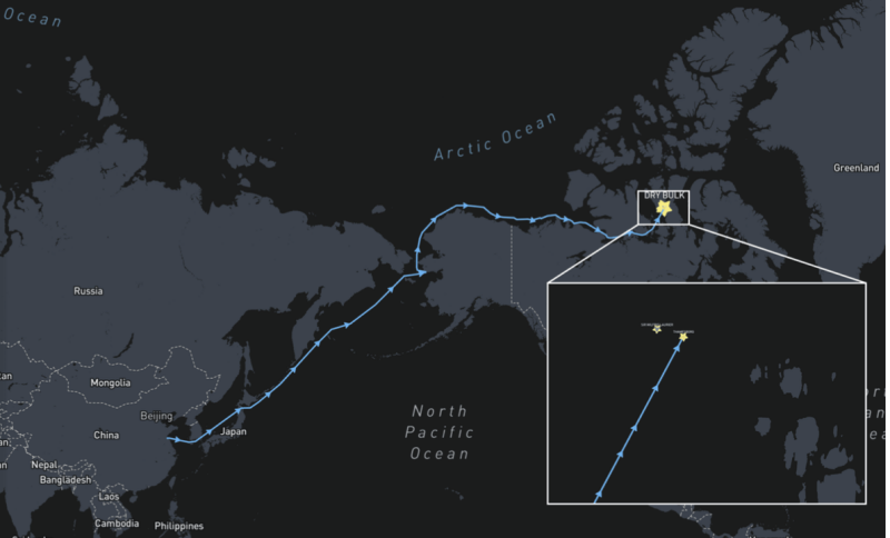
Thamesborg’s route from China to the Canadian Arctic and the vessel’s location in the Franklin Strait with CCGS Sir Wilfrid Laurier in proximity.
(Source: Shipatlas)


The Thamesborg incident highlights a broader challenge in the Arctic: the full picture of groundings and their causes may be obscured by the region’s remoteness, complicating investigations..
The foundational UNCLOS framework is being tested by competing claims, the Polar Code’s effectiveness is constrained by a lack of fundamental data, and the pace of hydrographic surveying is critically outmatched by the rapid increase in shipping traffic.
The reliance on century-old data poses an unacceptable risk, as evidenced by recent groundings.
The same factors driving increased access—climate change and economic interest—are also creating the conditions for a major maritime disaster.

The Arctic's transition from a frozen frontier to a viable trade route will only be truly safe and sustainable if the international community moves from a reactive posture to a proactive and unified approach to governance, infrastructure, and environmental stewardship.
The challenges of navigating the new Arctic are a test of the international community's ability to prioritize long-term safety and environmental protection over short-term economic and geopolitical gain.

Thursday, September 18, 2025

Experts warn against five polar geoengineering ideas

 
Stratospheric aerosol injection (SAI) in polar environments.
SAI in polar regions will not be possible year-round, due to winter darkness, and may have unwanted and unintended consequences for regional climates, including those across territorial boundaries.
The pale blue shading shows the effective time period for SAI in the Arctic.
The Inset icons (bottom right) show whether the option has been proposed for Antarctica, the Arctic, or both.
 
From Scripps 

Proposals will not help and could harm, according to new assessment

A team of international scientists is urging caution against five of the most-discussed polar geoengineering ideas, stating they are highly unlikely to help the polar regions and could harm ecosystems, international relations, and reduce our chances of reaching net zero by 2050.

These findings are outlined in a new assessment, published Sept. 9 in Frontiers in Science, which looked at several of the most developed geoengineering proposals currently being considered for use in Antarctica and the Arctic.
Led by the University of Exeter in England, the assessment was a collaborative effort involving co-authors from more than 30 organizations and universities, including UC San Diego’s Scripps Institution of Oceanography.

The project was initiated in early 2024, when this group of global experts came together to take a hard look at the major geoengineering ideas being proposed.

“We dug into all the relevant research and literature on polar geoengineering, and what we found was clear: none of the concepts stood up to scrutiny when it came to real-world feasibility or chances of success.
In fact, most of them are more likely to be environmentally dangerous, causing more harm than they seek to solve,” said Scripps Oceanography glaciologist Helen Amanda Fricker, one of the founding authors of the study and current director of the Scripps Polar Center.

The polar regions are home to fragile communities and ecosystems, as well as most of the world’s ice.
Technological ‘geoengineering’ approaches have been proposed to delay or address the impacts of climate breakdown in these regions.

Yet this new paper finds that five polar geoengineering proposals are likely to cost billions in set-up and maintenance, while reducing pressure on policymakers and carbon-intensive industries to reduce greenhouse gas emissions.
The proposals were also found likely to introduce additional ecological, environmental, legal and political problems.

"These ideas are often well-intentioned, but they‘re flawed.
As a community, climate scientists and engineers are doing all we can to reduce the harms of the climate crisis — but deploying any of these five polar projects is likely to work against the polar regions and planet,” said lead author Martin Siegert, a glaciologist at the University of Exeter.

"If we instead combine our limited resources towards treating the cause instead of the symptoms, we have a fair shot at reaching net zero and restoring our climate’s health,” said co-author Heidi Sevestre, a glaciologist working with the Secretariat of the Arctic Monitoring and Assessment Programme.

The proposals

 
Sea curtains to block warm water from flowing towards ice sheet grounding zones. Installing structures spanning many tens of kilometers is a massive technological challenge that will require operations across some of the world’s roughest seas and sustained work in ice-covered locations that even modern ice-strengthened vessels cannot always reach.
These curtains will probably have unwanted consequences on ocean circulation and ecosystems.
The pale blue bar shows the relatively short operational window for ships in the Amundsen Sea, Antarctica.
The Inset icons (bottom right) show whether the option has been proposed for Antarctica, the Arctic, or both.

To conduct the new assessment, the researchers looked at five geoengineering approaches that have received the most attention to date:stratospheric aerosol injections (SAI): releasing sunlight-reflecting particles such as sulfate aerosols into the atmosphere to reduce the sun’s warming effect;
sea curtains/walls: flexible, buoyant structures anchored to the seabed that aim to prevent warm deep water from reaching and melting ice shelves;
sea ice management: artificially thickening ice by pumping seawater onto it, or scattering glass microbeads on remaining sea ice to increase its reflectivity;
basal water removal: pumping subglacial water away from underneath glaciers in an effort to slow ice sheet flow and reduce ice loss;

ocean fertilization: adding nutrients such as iron to polar oceans to stimulate blooms of phytoplankton — microscopic creatures that draw carbon into the deep ocean when they die.

The team measured each proposal against their likely scope of implementation, effectiveness, feasibility, negative consequences, cost and existing governance frameworks that would allow timely deployment at scale.
They also assessed each proposal’s potential appeal to those vested in avoiding emissions cuts.

According to the assessment:

Effectiveness and feasibility: None of the ideas currently benefit from robust real-world testing.
No field experiments exist for sea curtains or sea ice reflection.
SAI has only been tested with computer modelling, ocean fertilization experiments were inconclusive, and glacier water removal has not been demonstrated beyond limited drilling.

The polar regions are some of the world’s harshest environments to work in, and even simple logistics are challenging to deploy.
The scale of polar geoengineering would require a human presence in the polar regions unlike anything we have considered to date, and many proposed ideas do not take these challenges into consideration.

Negative consequences: All proposals would bring intrinsic environmental damage, and sea ice management also carries major ecological risks, such as glass beads darkening the ice, and water pumps requiring vast infrastructure.
The risks of SAI include ozone depletion and global climate pattern change.
Sea curtains risk disrupting habitats, feeding grounds and the migration routes of marine animals, including whales, seals and seabirds.
Glacier water removal risks contaminating subglacial environments with fuels, and ocean fertilization carries uncertainty as to which organisms will flourish or decline, as well as the potential for triggering shifts in natural ocean chemical cycling.

Cost: The authors estimate that each proposal will cost at least $10 billion to set up and maintain.
Among the most expensive are sea curtains, projected at $80 billion over 10 years for an 80-kilometer (50-mile) structure.
(For context, the approximate perimeter of Antarctica is 53,610 kilometers (33,312 miles) and the approximate perimeter of Greenland's coastline is 44,087 kilometers (27,394 miles).
They caution that these costs are likely underestimates, and warn that they will be higher still once knock-on consequences, such as environmental and logistical impacts, are included.

Governance: No governance frameworks exist to regulate SAI or sea ice management.
Sea curtains and glacier water removal would fall under Antarctic Treaty provisions, while ocean fertilization is treated as marine pollution and restricted under United Nations rules.
All proposals would require extensive political negotiation and the creation of new governance structures and infrastructure.

Scale and timing: The authors conclude that, even if the proposals offered some benefit, none can be deployed at sufficient scale, and fast enough, to tackle the climate crisis within the limited time available.

Vested interest appeasement: The authors found that all proposals risk appealing to those seeking to avoid emissions cuts.
They note that claims about sea ice management preserving Indigenous Peoples’ rights and environments are misleading, and stress that only rapid decarbonization can achieve this without the risks.
Using glass beads as a means to reflect sunlight off polar surfaces.
Changing albedo by adding particles to the ocean may actually decrease albedo, would require deliberate pollution of ecosystems, and may cross governance boundaries.
It is also unlikely to be logistically possible to operate at the scale necessary to make a significant difference.
The inset icons (bottom right) show whether the option has been proposed for Antarctica, the Arctic, or both.

Split resources

Geoengineering is a divisive topic among experts.
Some cite large uncertainties in effectiveness, risks of negative consequences, and major legal and regulatory challenges.
Others argue that geoengineering could buy time while the world cuts emissions, and warn against dismissing proof-of-concept research.
Arctic sea-ice thickening to counteract the loss of ice.
Techniques to thicken sea ice would require a very large number of individual devices to be deployed onto the winter sea ice, and it is unlikely to be logistically possible to operate at the scale necessary to make a significant difference.
The inset icons (bottom right) show whether the option has been proposed for Antarctica, the Arctic, or both.
 
Although the authors acknowledge the importance of explorative research, they say that continuing to pursue these five polar geoengineering proposals could shift focus from the urgent systemic change needed to cut greenhouse gas emissions.
This, they argue, risks splitting monetary and research resources when time is of the essence.

"Mid-century is approaching, but our time, money and expertise is split between evidence-backed net zero efforts and speculative geoengineering projects,” said Siegert.
“We're hopeful that we can eliminate emissions by 2050, as long as we combine our efforts towards reaching zero emissions."
"While research can help clarify the potential benefits and pitfalls of geoengineering, it’s crucial not to substitute immediate, evidence-based climate action for as-yet unproven methods,” said Sevestre.
“Crucially, these approaches should not distract from the urgent priority of reducing emissions and investing in proven mitigation strategies.” 

Subglacial water removal in ice sheets to slow ice flow to the ocean.
Drilling to the bed of thick, flowing ice is highly technologically challenging and has never been undertaken for the sustained period required to maintain the drainage of subglacial water.
Subglacial drainage networks are currently pristine and not well mapped, so the introduction of drill holes into the network will probably be highly challenging to achieve reliably and could cause contamination both below and above the ice.
The inset icons (bottom right) show whether the option has been proposed for Antarctica, the Arctic, or both.
 
Ocean fertilization to “draw down” atmospheric CO2. Negative impacts will likely include changes to food web structure, and fertilization could affect nutrients and fisheries elsewhere, including across territorial or governance boundaries.
The inset icons (bottom right) show whether the option has been proposed for Antarctica, the Arctic, or both.
   
They note that while their assessment focuses on the polar areas, other geoengineering ideas, such as marine cloud brightening and space-based solar reflectors, also need to be assessed against these criteria.

“The good news is that we have existing goals that we know will work.
Global heating will likely stabilize within 20 years of us reaching net zero.
Temperatures would stop climbing, offering substantial benefits for the polar regions, the planet and all lifeforms,” said Siegert.

A total of 42 researchers from 36 organizations co-authored the assessment.
While the study received no direct funding, individual researchers are supported by various funders, including Fricker’s work, which was funded by Eric and Wendy Schmidt.
The full list is available in the study.


Wednesday, September 17, 2025

Advanced spoofing hides Russian oil transfers in Gulf of Oman


The Gulf of Oman is key hub for the movement of sanctioned oil, mainly Iranian crude.

From LloydsListIntelligence by Bridget Diakun
  • Transhipment of Russian oil in the Gulf of Oman area on the rise
  • Regulatory scrutiny encourages sanctions evaders to develop more advanced deceptive practices
  • Spoofing that more closely resembles normal sailing movements used
Manipulation of AIS data is evolving, further complicating efforts to track sanctions-skirting tankers 

RUSSIA’S shadow fleet tankers are using sophisticated spoofing methods to disguise ship-to-ship transfers in the Gulf of Oman to circumvent sanctions and avoid detection by watchful regulators.

Analysts at energy intelligence provider Vortexa first spotted the transhipment of Russian oil in this area in February 2024.

At the time it was an infrequent occurrence, but this activity is on the rise and becoming more difficult to spot as tankers manipulate their positional data in increasingly sophisticated ways to avoid detection.

Vortexa senior freight analyst Mary Melton said STS transfers in the Gulf of Oman enabled the transfer of Russian crude from a US Office of Foreign Assets Control-designated tanker to a non-Ofac-sanctioned tanker, which could then deliver the cargo to India or China.

“Logistically, it also enables the sanctioned tankers to conduct the STS in a location further away from the ultimate discharge port and head back to Russia to load more quickly,” Melton said.

Aframax Rozmarine (IMO: 9250531), for example, departed the port of Murmansk on January 28, two weeks after it was sanctioned by Ofac, laden with 738,000 barrels of Novy Port crude.

Rozmarine (IMO: 9250531) and Prisma (IMO: 9299678) spoof AIS data to mimic normal sailing while in a ship-to-ship transfer in Gulf of Oman
 
It entered the Gulf of Aden on February 18 and started manipulating its positional information within days.

At this point the Automatic Identification System trace, which showed the vessel taking a seemingly normal route up to the Gulf of Oman before turning back, is falsified.

Rozmarine conducted a STS transfer with Sierra Leone-flagged Prisma (IMO: 9299678) during this period, according to Vortexa.

Prisma also spoofed its location at this time, showing itself as manoeuvring off the southern coast of Oman, near Duqm.

The cargo was delivered by Prisma to Lanshan, China at the end of March.


SynMax Intelligence, a US intelligence company, identified another event following the same modus operandi.

Suezmax Canara (IMO: 9411331), sanctioned by Ofac in early January, loaded in the arctic port of Murmansk from April 30 to May 2.

The ship then sailed via the Red Sea route to the Gulf of Aden indicating its destination as “China for order”.

Canara disabled its AIS data on 29 May while off the coast of Oman. It was offline for just over 16 days.

SynMax Intelligence tracked Canara conducting a STS transfer with Vernal (IMO: 9207027) between June 13 and 14 in the Gulf of Oman, north of Muscat.

Vernal was manipulating its AIS data over this period.

The cargo was discharged in India.

Vernal and Prisma were sanctioned by the EU on July 20 but neither have been designated by Ofac.

The evolution of deceptive shipping practices in this area is down to the continuous monitoring by Washington of illicit trading activities, said Signal analyst Maria Bertzeletou.
“The US has been imposing successive rounds of sanctions to drive such trade toward zero and reinforce the effectiveness of its sanctions regime.”

The enhanced scrutiny requires those engaging in sanctioned oil trades to be more inventive to evade detection, creating additional challenges for those trying to track this activity, particularly for businesses attempting to limit their exposure to potentially risky trade.

“Sophisticated spoofing can appear completely normal, even to the trained eye, making it a significant challenge for risk and compliance professionals to detect,” said a SynMax Intelligence analyst.

The Gulf of Oman is key hub for the movement of sanctioned oil, mainly Iranian crude.

At the time of writing there are 142 shadow* fleet tankers in the area. Many of these vessels are spoofing their AIS to appear in certain locations within the Gulf of Oman.
In reality, they are either conducting dark STS transfers nearby or loading in an Iranian port.

* Lloyd’s List defines a tanker as being part of the Shadow Fleet if it engages in one or more deceptive shipping practices indicating that it is involved in the facilitation of sanctioned oil cargoes from Iran, Russia or Venezuela. Or it is sanctioned for participation in sanctioned oil trades or is sanctioned for links to a company that is sanctioned for facilitating the export of sanctioned oil.


Tuesday, September 16, 2025

‘Enormous’ mountain on Pacific seafloor rivals Rocky Mountain peaks, NOAA says


A map showing the depth extent of an unnamed seamount that was fully mapped as part of Beyond the Blue: Palau Mapping 2 expedition.
This massive mountain in the west Pacific is about 2.6 miles tall, yet its peak remains 800 feet below the surface, NOAA Ocean Exploration says. 
Image courtesy of NOAA Ocean Exploration, 2025 Beyond the Blue.
 
From The Telegraph by Mark Price 
 
An “enormous” submerged mountain that rivals peaks in the Rockies has been mapped for the first time in a previously unexplored area of the western Pacific, according to NOAA Ocean Exploration.
 
Map showing the tentative track of NOAA Ship Okeanos Explorer during the second Beyond the Blue: Palau Mapping expedition (EX2506) as well as sites for potential collection of water samples to analyze for environmental DNA (eDNA).
Image courtesy of NOAA Ocean Exploration.

The seamount is 250 miles north of Palau — an island country east of the Philippines — and multibeam sonar revealed its peak is hidden about 800 feet below the surface.
 
NGA nautical raster chart and STRM bathyemtry with the GeoGarage platform

“This seamount stretches from the abyssal plain at roughly 4,400 meters (2.7 miles) depth to its peak — meaning it is about 4,200 meters (2.6 miles) tall,” NOAA marine policy fellow Garret O’Donnell wrote in a field report posted Sept.2.
 
The location of the unnamed seamount mapped during the Beyond the Blue: Palau Mapping 2 expedition relative to the ship’s trackline shows the lawn mowing survey pattern and position north of Palau.
Image courtesy of NOAA Ocean Exploration, 2025 Beyond the Blue.
 
“By comparison, Pikes Peak, one of Colorado’s fabled ‘14’ers’ — that is, mountains that reach over 14,000 feet in elevation — stands at 14,110 feet (4,302 meters) tall. This unnamed undersea mountain would look right at home among the American Rockies instead of submerged beneath the choppy waters of the western Pacific Ocean.” 
 
An echogram, which is a visual representation of the sonar data.
This echogram was produced during the calibration of the ship's sonars.
 
Evidence of a peak below the surface appeared in nautical charts in 2023, but the scientists were taken off guard by “the sheer scale of what’s beneath,” Garrett wrote.
“It’s funny to me that were we not actively mapping these features, we would have no idea that a mountain half the height of Mount Everest lies directly beneath us,” he said.
“I can’t help but think about the variety of organisms and geologic features that sit below us, undisturbed and undiscovered.

Maybe one day the map we made of this behemoth will be used to navigate the feature with a remotely operated vehicle to get a closer look.” 
NOAA Ocean Exploration visited the site as part of the Beyond the Blue expedition, which is exploring mysterious deep water regions of the Palau National Marine Sanctuary.
Seamounts are typically extinct volcanoes that either didn’t reach the surface or were submerged over the centuries, experts say.
It’s suspected there may be 100,000 seamounts hidden in the world’s oceans, “however, less than one-tenth of a percent of the seamounts in the world have been explored,” NOAA says.

Monday, September 15, 2025

Decades-old barrels of industrial waste still impacting ocean floor off LA

A discarded barrel with halo on the seafloor off the coast of Los Angeles, captured by remotely operated vehicle SuBastian.
Credit: Schmidt Ocean Institute.

From ScmidtOcean

Initially thought to contain the pesticide DDT, study reveals some barrels contained caustic alkaline waste
 
In 2020, haunting images of corroded metal barrels in the deep ocean off Los Angeles leapt into the public consciousness.
Initially linked to the toxic pesticide DDT, some barrels were encircled by ghostly halos in the sediment.
It was unclear whether the barrels contained DDT waste, leaving the barrels’ contents and the eerie halos unexplained.

Now, new research from UC San Diego's Scripps Institution of Oceanography reveals that the barrels with halos contained caustic alkaline waste, which created the halos as it leaked out.
Though the study’s findings can’t identify which specific chemicals were present in the barrels, DDT manufacturing did produce alkaline as well as acidic waste.
Other major industries in the region such as oil refining also generated significant alkaline waste.

“One of the main waste streams from DDT production was acid and they didn’t put that into barrels,” said Johanna Gutleben, a Scripps postdoctoral scholar and the study’s first author.
“It makes you wonder: What was worse than DDT acid waste to deserve being put into barrels?”


Researchers use Remotely Operated Vehicle SuBastian to collect sediment push cores next to barrels discarded on the seafloor.
Credit: Schmidt Ocean Institute.


The study also found that the caustic waste from these barrels transformed portions of the seafloor into extreme environments mirroring natural hydrothermal vents — complete with specialized bacteria that thrive where most life cannot survive.
The study authors said the severity and extent of this alkaline waste’s impacts on the marine environment depend on how many of these barrels are sitting on the seafloor and the specific chemicals they contained.

Despite these unknowns, Paul Jensen, emeritus marine microbiologist at Scripps and senior author of the study, said that he would have expected the alkaline waste to quickly dissipate in seawater.
Instead, it has persisted for more than half a century, suggesting this alkaline waste “can now join the ranks of DDT as a persistent pollutant with long-term environmental impacts.”

The study, published today in the Proceedings of the National Academy of Sciences Nexus and supported by NOAA and the University of Southern California’s Sea Grant program, continues Scripps’ leadership role in unspooling the toxic legacy of once-legal ocean dumping off the coast of Southern California.
The findings also provide a way of visually identifying barrels that formerly contained this caustic alkaline waste.

“DDT was not the only thing that was dumped in this part of the ocean and we have only a very fragmented idea of what else was dumped there,” said Gutleben.
“We only find what we are looking for and up to this point we have mostly been looking for DDT.
Nobody was thinking about alkaline waste before this and we may have to start looking for other things as well.”

From the 1930s until the early 1970s, 14 deep-water dump sites off the coast of Southern California received “refinery wastes, filter cakes and oil drilling wastes, chemical wastes, refuse and garbage, military explosives and radioactive wastes,” according to the EPA.
A pair of Scripps-led seafloor surveys in 2021 and 2023 identified thousands of objects, including hundreds of discarded military munitions.
The number of barrels on the seafloor remains unknown.
Sediments in the area are heavily contaminated with the pesticide DDT, a chemical banned in 1972 now known to harm humans and wildlife.
Scant records from this time period suggest DDT waste was largely pumped directly into the ocean.

Gutleben said she and her co-authors didn’t initially set out to solve the halo mystery.
In 2021, aboard the Schmidt Ocean Institute’s Research Vessel Falkor, she and other researchers collected sediment samples to better understand the contamination near Catalina.
Using the remotely operated vehicle (ROV) SuBastian, the team collected sediment samples at precise distances from five barrels, three of which had white halos.

The barrels featuring white halos presented an unexpected challenge: Inside the white halos the sea floor suddenly became like concrete, preventing the researchers from collecting samples with their coring devices.
Using the ROV’s robotic arm, the researchers collected a piece of the hardened sediment from one of the halo barrels.

DDT was not the only thing that was dumped in this part of the ocean and we have only a very fragmented idea of what else was dumped there.
We only find what we are looking for and up to this point we have mostly been looking for DDT.
Nobody was thinking about alkaline waste before this and we may have to start looking for other things as well.Johanna Gutleben, postdoctoral scholar at Scripps and first author

The team analyzed the sediment samples and the hardened piece of halo barrel crust for DDT concentrations, mineral content and microbial DNA.
The sediment samples showed that DDT contamination did not increase closer to the barrels, deepening the mystery of what they contained.

During the analysis, Gutleben struggled to extract microbial DNA from the samples taken through the halos.
After some unsuccessful troubleshooting in the lab, Gutleben tested one of these samples’ pH.
She was shocked to find that the sample’s pH was extremely high — around 12.
All the samples from near the barrels with halos turned out to be similarly alkaline.
(An alkaline mixture is also known as a base, meaning it has a pH higher than 7 — as opposed to an acid which has a pH less than 7).

This explained the limited amount of microbial DNA she and her colleagues had been able to extract from the halo samples.
The samples turned out to have low bacterial diversity compared to other surrounding sediments and the bacteria came from families adapted to alkaline environments, like deep-sea hydrothermal vents and alkaline hot springs.

Analysis of the hard crust showed that it was mostly made of a mineral called brucite.
When the alkaline waste leaked from the barrels, it reacted with magnesium in the seawater to create brucite, which cemented the sediment into a concrete-like crust.
The brucite is also slowly dissolving, which maintains the high pH in the sediment around the barrels, and creates a place only few extremophilic microbes can survive.
Where this high pH meets the surrounding seawater, it forms calcium carbonate that deposits as a white dust, creating the halos.


Paul Jensen and Johanna Gutleben of UC San Diego's Scripps Institution of Oceanography unload and sort sediment cores after the samples were brought to the surface from known dumping sites by Remotely Operated Vehicle (ROV) SuBastian during a July 2021 expedition aboard Research Vessel Falkor.
Credit: Schmidt Ocean Institute.


“This adds to our understanding of the consequences of the dumping of these barrels,” said Jensen.
“It’s shocking that 50-plus years later you’re still seeing these effects.
We can’t quantify the environmental impact without knowing how many of these barrels with white halos are out there, but it’s clearly having a localized impact on microbes.”

Prior research led by Lisa Levin, study co-author and emeritus biological oceanographer at Scripps, showed that small animal biodiversity around the barrels with halos was also reduced.
Jensen said that roughly a third of the barrels that have been visually observed had halos, but it’s unclear if this ratio holds true for the entire area and it remains unknown just how many barrels are sitting on the seafloor.

The researchers suggest using white halos as indicators of alkaline waste could help rapidly assess the extent of alkaline waste contamination near Catalina.
Next, Gutleben and Jensen said they are experimenting with DDT contaminated sediments collected from the dump site to search for microbes capable of breaking down DDT.

The slow microbial breakdown the researchers are now studying may be the only feasible hope for eliminating the DDT dumped decades ago.
Jensen said that trying to physically remove the contaminated sediments would, in addition to being a huge logistical challenge, likely do more harm than good.
“The highest concentrations of DDT are buried around 4 or 5 centimeters below the surface — so it’s kind of contained,” said Jensen.
“If you tried to suction that up you would create a huge sediment plume and stir that contamination into the water column.”

In addition to Gutleben, Jensen and Levin, Sheila Podell, Douglas Sweeney and Carlos Neira of Scripps Oceanography co-authored the study, alongside Kira Mizell of the U.S. Geological Survey.

Additional information on Scripps Oceanography research underway on the DDT dumpsite offshore Southern California can be found here: https://scripps.ucsd.edu/ddtcoastaldumpsite.

Sunday, September 14, 2025

More than 4,700 bew premium cars wiped out: the worst car carrier ship disaster costs billions $


In March 2022, the Felicity Ace caught fire and sank near the Azores some 25 NM outside of the limits of Portugal'EEZ, in an area with a depth of about 9,842 feet according the Portuguses Navy, dragging thousands of luxury cars to the bottom of the sea. 
On board were some of the world's most coveted brands: Porsche, Audi, Bentley, Lamborghini... a veritable fortune swallowed up by the sea.
Since then, the wreck has become one of the most fascinating modern shipwrecks in the Atlantic, captivating the imagination with its combination of wealth, tragedy, and mystery. 
What lies in its sunken holds today? S
Symbols of prestige that still sparkle, or mere corroded relics of human desire?
But there is a darker side to the story: the fear of fuel leaks, batteries, and materials that could threaten fragile marine ecosystems.
The Felicity Ace is a reminder that, in the face of the ocean's power, even the pinnacle of luxury is nothing—and that all human ambition carries risk when it challenges the depths.