Saturday, November 22, 2025

1711 Moll map of the World showing Trade Winds

 
courtesy of Geographicus

 This is Herman Moll's 1711 chart of world trade winds, an early example of a meteorological chart based on Edmond Halley's seminal 1686 map.
This first printing of the map is notable for reflecting the state of European geographic and scientific knowledge at the time, making new discoveries but with many uncertainties remaining, as with the coasts of Australia, New Zealand, and California.
 
Centered on the Pacific Ocean, the map is crisscrossed by lines representing the prevailing winds at various times of the year.
Arrows in 'void spaces' (especially the Pacific) demonstrate shifting trade winds.
The regularity of winds around the Indian Subcontinent and between Mainland and Insular Southeast Asia (i.e., the monsoons) indicates why these regions have carried on extensive maritime trade for many centuries.
The map is also notable for including a 'line of no variation' (agonic line), that is, a line where there would be no magnetic variation between north on a compass and true north, another important contribution of Halley (subsequent research has shown that this line is constantly moving due to fluid motion in the Earth's core).

This map is also significant for demonstrating contemporary cartographic debates.
The coasts of Australia, Diemen's Land (Tasmania), and New Zealand are partially mapped, based on Dutch explorations of the 17th century, but these would not be fleshed out until Cook's voyages some 60 years after this map's publication.
Also important is the mapping of California as an island - a convention Moll wholeheartedly embraced - just below and to the right of the title box.
The British Empire is noted on the east coast of North America leading to a surprisingly inaccurate, amoeba-like mapping of Cape Cod.
 
The present map is based on Edmond Halley's untitled 1686 map, commonly known as 'Halley's Chart of the Trade Winds,' that appeared in the journal.
Halley's original was centered on Africa and eschews the Pacific entirely, whereas Moll had placed the Pacific at center.
Moll has also extended the scope further north and south, and added the information about monthly and seasonal wind variations.
In other words, Moll has added significantly to Halley's original map, which is considered to be the earliest meteorological map.
                            

Friday, November 21, 2025

On a dangerous mission with the "Malizia Explorer"

Photo: Andreas Lindlahr
The "Malizia Explorer" on its way across the Atlantic.
 
From Yacht by Ursula Meer
 
A team of scientists, journalists and sailors has been on an unusual expedition to Antarctica with Boris Herrmann and his new research vessel "Malizia Explorer" since yesterday (18 November 2025).
The destination is the remote Danger Islands, a remote group of islands at the northern tip of the Antarctic Peninsula.
During the mission, which will last several weeks, the team intends to carry out the first detailed field study of this region, which is home to the largest colony of Adelie penguins in the world.
The data collected will serve as a basis for future marine conservation measures and possibly create a model for the protection of other Antarctic regions.

Ushuaia, the southernmost major city in the world, is the starting point for this extraordinary research adventure.
A 14-strong team is setting off for Antarctica on the 26-metre-long "Malizia Explorer".
Unlike typical Antarctic expeditions, which are carried out on large ships, the team led by ocean racing sailor Boris Herrmann is using a robust sailing boat.
 
Localization of the Danger islands with the GeoGarage platform
(UKHO and NGA nautical raster charts)
 
Their destination is the Danger Islands - a remote archipelago of seven small islands that only became the focus of research six years ago when scientists discovered the world's largest colony of Adelie penguins there: over one million breeding pairs on just five square kilometres.
The expedition brings together scientists, sailors and journalists who want to explore this unspoilt wilderness together.

The "Malizia Explorer": a robust research sailboat instead of a racing Imoca

26 metres long, almost 7 metres wide, more than 60 tonnes of aluminium: the "Malizia Explorer" is impressive for its dimensions alone.
The Garcia 85, originally built in 2005 as the "Beniguet" and later used as the luxury charter "Fani", was taken over by Boris Herrmann and his team in Lorient in spring 2025.
The ship has a 36 metre high mast and a 19 tonne hydraulically operated keel.
In contrast to the racing Imoca, the "Malizia Explorer" is designed for robustness, independence and long research trips to remote regions. 

Boris Herrmann sees the ship as a logical development of his team's "Climate Action Now" mission.
It is intended to help broaden the scope and spread the message about marine conservation and climate change.
"I've been campaigning for this for a long time.
If you don't try, you don't win.
We want to show that you can make meaningful contributions to research with a sailing yacht - especially in places where large ships can't go," says Herrmann, explaining the motivation behind the project.
He is supported by Pierre Casiraghi and Prince Albert II of Monaco, who have been committed to protecting the oceans for years.

The ship is equipped with state-of-the-art technology, including an OceanPack laboratory for recording oceanographic data such as salinity, temperature and CO2 content.
The spacious saloon was completely remodelled for the expedition and is full of scientific equipment, computers and chargers.
All 14 beds in the five cabins are occupied - seven scientists, four sailors and three journalists share the limited space on board.

YACHT author Andreas Lindlahr accompanied the Malizia Explorer on its journey from Almerimar via Senegal to South America.
In YACHT 01/2026 (on newsstands from 10 December), he describes the special journey on a special boat.

Boris Herrmann and Team Malizia are proud to announce an exciting new chapter in their mission to further Ocean science and inspire ambitious climate action: the acquisition of a sailing research vessel. Named Malizia Explorer, the research vessel marks a significant step forward in the team's ongoing efforts to collect data in remote and relevant Ocean regions, further scientific research and raise public awareness about the crucial role the Ocean plays in our climate system.
 
The challenges of travelling to Antarctica

Before the research work on the islands can begin, the team has to cross the notorious Drake Passage - one of the stormiest sea areas in the world.
Boris Herrmann has hired an experienced Antarctic sailor for the challenging voyage: Argentinian Lucas Lanusse.
On the electronic weather chart at the navigation table, the skipper shows the dark red zones that quickly pass between Cape Horn and the Antarctic Peninsula and indicate violent storms.
"You should set off when a low-pressure area leaves and try to cross the passage before the next one approaches," explains Lanusse in a film report by ZDF the strategy for the crossing.
Even for the experienced sailor, this expedition is not like any other trip: "Sailing to the Danger Islands is the biggest challenge of my life.
I'm really looking forward to it, but it will be tough for all of us."  

 
 Photo: Screenshot windy.com
The sailing strategy in the rough Drake Passage is simple: set off when a low has passed and hope that the next one takes its time.

Germany's first protected area in the Antarctic

The Danger Islands are of particular importance to German environmental protection.
In 2024, they were designated as the first German protected area in the Antarctic.
"We worked on this for five years," says Fritz Hertel from the Federal Environment Agency.
As a member of the polar team, he is responsible for authorising German expeditions and tourist activities in Antarctica.
The agency even had to review its own mission, as access to the Danger Islands is only permitted with a special permit.
"Now we can finally see and experience the area for ourselves, which we have previously explored from afar from our desks," explains Hertel.
Germany has committed to regularly monitoring the area, as the penguins are considered important indicators of the state of the Antarctic ecosystem and their population development reveals a lot about the effects of climate change.

The scientific programme of the expedition covers various areas of research.
The "The islands are untouched wilderness," says Osama Mustafa from the Thuringian Institute for Sustainability and Climate Protection.
The polar expert from Jena is leading the scientific team and has clear ideas about the research objectives: "Our main goal is to preserve the huge penguin colony." To achieve this goal, the team wants to use drones to count the animals and collect rock samples.
At the same time, bird expert Simeon Lisovski from the Alfred Wegener Institute plans to take blood samples from the penguins to analyse them for diseases such as bird flu.
The scientists want to use the data to gain a better understanding of the fragile ecosystem and develop protective measures.
The research results should also help to strengthen the protected status of the islands and possibly extend it to the surrounding marine areas.


Safety has top priority


The Danger Islands are not only a challenge because of the difficult journey.
There are hardly any reliable nautical charts, the waters are shallow and full of drift ice.
"The Antarctic is never safe," emphasises Fritz Hertel, who is on board for the Federal Environment Agency.
"If something happens, help is days away."
Accordingly, the team worked meticulously to ensure their safety.
The expedition members have packed emergency bags with sleeping bags, gas cookers and food rations for every trip ashore in case it is suddenly no longer possible to return to the sailing boat.
Shortly before setting off, there is a mixture of excitement and awe in the group.
Skipper Lanusse summarises the feelings: "For me, Antarctica is like another planet. No greenery, just cold, storms and huge icebergs. It feels like you're a long way from home."

Political dimension of the project

The expedition has a political dimension as well as a scientific one.
The Danger Islands were designated as an Antarctic Specially Protected Area (ASPA 180) in 2024 - the first protected area in the Antarctic initiated by Germany.
The USA was a co-applicant.
As initiators of the new protected area, Germany and the USA are now responsible for the management of the Danger Islands.
Most of the 76 protected areas in Antarctica are located on the coast, but only a few also include the neighbouring marine areas.
Until now, it has been much easier to establish protected areas on the mainland than in marine regions with potentially lucrative fishing grounds.
Germany is endeavouring to extend the protected status of ASPA 180 to the penguins' main feeding grounds in the sea around the seven islands.
The scientific findings of the expedition should provide the necessary basis for this.
 
Links :

Thursday, November 20, 2025

How China became a wedge between two South Pacific neighbors

 
The resort region of Rarotonga, the largest island of the Cook Islands, in 2012.
Credit... Marty Melville/Agence France-Presse — Getty Images

From NYTimes by Victoria Kim

A standoff between New Zealand and the Cook Islands reflects an urgent question in the Pacific: Is China a threat or a partner for growth?

Every year, tens of thousands of tourists visit the pristine beaches and turquoise lagoons of the Cook Islands in the South Pacific.
Their business sustains this small nation of 15 islands and atolls, where no building is taller than a coconut tree.


Most travelers come from New Zealand, the Cook Islands’ former colonial ruler, and the two have long had close ties.
But in recent months, they have been locked in an icy standoff.

The fallout was over a wide-ranging partnership agreement the Cook Islands signed this year with China.
The deal, viewed as the latest sign of China’s encroachment in the region, has alarmed New Zealand.

New Zealand has put on hold millions of dollars in aid, leaving a hole in the Cook Islands’ budget.
Prime Minister Mark Brown of the Cook Islands has threatened to “go somewhere else” for his country’s infrastructure needs.
There have been accusations of New Zealand using aid as a bargaining chip, and rare protests in Rarotonga, the main island, by people concerned about jeopardizing ties with New Zealand.

Even after the two countries’ leaders met face to face last week at a regional forum, there has been no sign of a breakthrough.

“It was a serious change when they entered those arrangements with China, and we knew nothing of it,” New Zealand’s foreign minister, Winston Peters, said in an interview last month.

 
Foreign Minister Tingika Elikana of the Cook Islands, left, and his Chinese counterpart, Wang Yi, meeting in Xiamen, China, in May.Credit...Ding Lin/Xinhua, via Getty Images

New Zealand argues that the Cook Islands was obligated to consult with it before signing the deal, and says there will be no new aid until steps are taken to “repair the relationship and restore trust.” Mr.
Brown has pointed out that New Zealand signed its own partnership agreement with China in 2014 — without consulting the Cook Islands — reaping tens of billions of dollars in economic gain.

But in the decade since that agreement, New Zealand has grown increasingly wary of China’s intentions in its vicinity.
It has watched as China used coercive trade measures to hamstring Australia’s economy, test fired an intercontinental ballistic missile into the Pacific, and sent a naval task force into the waters between Australia and New Zealand to carry out live fire drills.

Mr.
Peters said that China’s deal with the Cook Islands “fits a certain recent developmental pattern” of Beijing’s ambitions in the region.

Diplomats from the Cook Islands and New Zealand were “working their way through” the former’s agreement with China to work out points of concern, New Zealand officials said.

The paused funding — worth 18.2 million New Zealand dollars, or about $11 million — was for health, education and tourism; a separate $3 million in aid for cybersecurity is still being provided, according to New Zealand’s Ministry of Foreign Affairs and Trade.

Analysts said that the pause in aid was an extraordinary move by New Zealand.
It is a different tack from Australia, which has dramatically increased aid spending in the region.

Since 1965, the Cook Islands has been self-governing, but relies on New Zealand for defense.
Cook Islanders hold New Zealand passports and the majority of them — nearly 85,000 — live in New Zealand.
The parameters of their relationship are being tested as China has deepened its presence in the Pacific.

 
A tourist market on the main island of Rarotonga in June.
Most travelers come from New Zealand.
Credit...William West/Agence France-Presse — Getty Images


In 2022, China signed a security agreement with the Solomon Islands, another small Pacific nation, heightening fears that Beijing was aiming to establish a military foothold in the region.
Both Chinese and Cook Islands officials have said that their pact does not include security or military matters.

New Zealand’s intelligence chief, in a speech earlier this year, warned that China’s ambition in making inroads into the Pacific was to “link economic and security cooperation, create competing regional architectures.” China’s Embassy in Wellington called his comments disinformation, saying there is no “secret agenda” to the Cook Islands agreement.

David Capie, director of the Centre for Strategic Studies at Victoria University of Wellington, said it was clear that New Zealand’s objections had to do with Beijing signaling increased military ambitions in the region.

“In a different strategic context, that was fine. With different partners, that was probably fine,” he said.
“The strategic context has changed.”

The Cook Islands, one of the smallest of the Pacific island nations, has also been a focal point of emerging competition over seabed mining.
The agreement with China included pledges to cooperate on exploring seabed minerals.
The United States last month reached its own deal with the Cook Islands on mining the sea floor.

Rashneel Kumar, editor of Cook Island News, which broke the news of New Zealand’s funding pause, said that, like other small Pacific island nations with developmental challenges and climate change risks, his country needed support wherever it could get it.
All around Avarua, the capital, are physical reminders of this — the courthouse, the police headquarters, the national stadium, each built by China.

“The feeling is there that China has helped us in some areas and we are grateful for that,” he said.
“But the general consensus is, we should be careful who we partner with.”

Links :

Wednesday, November 19, 2025

The Murillo hoax

[Murillo Velarde Map of 1734] Carta Hydrographica y Chorographica de las Yslas Filipinas
Author/s: Santiago A. Pilar / Updated by Cecilia S. De La Paz
URL: https://epa.culturalcenter.gov.ph/3/82/2233/
Copyright © 2020 by Cultural Center of the Philippines


Detail of 1734 Murillo map
 

From The ManilaTimes by Rigoberto D. Tiglia

IT is one of the biggest hoaxes among false historical narratives: the claim that the 1734 map drawn by Jesuit missionary Pedro Murillo Velarde depicted Scarborough Shoal (Bajo de Masinloc) as part of Las Islas de las Filipinas that was a Spanish colony, and therefore what was ceded to the US in 1898 as Philippine territory included it.

The hoax is one of the five fallacies* widely disseminated by the Americans and their puppets here to create Sinophobia in the country, each of which I will debunk in this series.
I dare Antonio Carpio, the main purveyor of these lies, and the robotic Jay Tarriela to disprove my assertions.

This Scarborough-is-ours narrative has been spread since 2017 principally by former justice Antonio Carpio and repeated uncritically by journalists and diplomats.
It is a cleverly manufactured lie.Evading justice by invoking an imagined prescriptive period

The map’s valuation over the years is intriguing, to say the least.
It was first auctioned for P186,000 in 1991, and another copy was offered in 2012 at P1.3 million.
Local tycoon Mel Velarde — encouraged by Carpio and probably because he shared the same name with the cartographer — bought it for P12 million in 2014, after it was hyped by the former justice as proving our sovereignty over Scarborough.
Was the map Velarde bought in 2014 the map purchased for P1.3 million in 2012? 
Whoever that is must have laughed all the way to the bank at what Carpio called the “Mother of Philippine Maps.”

President Ferdinand Marcos Jr. again demonstrated his gullibility in believing anti-China narratives that in the December 2024 ceremony in which the map was donated to MalacaƱan Palace, he said: ”The Murillo Velarde map provided critical evidence (in the arbitration suit against China) to demonstrate that the Philippines has continuously exercised authority and jurisdiction over what it is identified as Panacot Shoal — now Scarborough Shoal.”

Marcos is so wrong: The arbitral panel’s 2016 decision didn’t even mention the Murillo map or any of the maps that the Philippines submitted, as it is a well-known fact that maps are never considered proof of sovereignty unless annexed to a treaty.

It is a testament to the power of media that the Murillo hoax still persists despite hard evidence against it.

Carpio’s hoax is based on the fabrication that the Panacot Shoal in the Murillo Velarde map is the same marine formation as Scarborough Shoal, by another name (image 1).

It is not.
Panacot is a shoal that, at 39 nautical miles, is so near to the Zambales mainland that fishermen during the Spanish period routinely passed through it and had given it a name.
Scarborough Shoal is 116 nautical miles, approaching the high seas (image 2).

It was discovered only in 1748 when the warship HMS Scarborough, which was traveling from England to China found itself grounded on it.
The shoal was named after the frigate and depicted prominently in European maps — precisely located at 117°50′ East — to warn ships of this hazard, which was so dangerous it could ground a warship.
The Spanish instead called it Bajo de Masinloc in 1808, which means the “shallows of Masinloc,” referring to the town in Zambales nearest to it.

I found on the websites of rare-map dealers maps which show that the two are different shoals.
One is the 1774 “D’Anville” map chart of the China Sea, which shows a “Scarboro,” with two other features about 80 nautical miles away that, if compared to the Murillo map and another map described below, are the Panacot and Galit shoals.
 
courtesy of Raremaps

Different

A second map made in 1778 that indubitably proves that Scarborough is different from Panacot is “A chart of the China Sea and Philippine Islands with the archipelagos of Felicia and Sooloo”.

courtesy of Raremaps
 
1778 British map shows Scarborough and Panacot are entirely different features.
Better resolution of these maps at my website rigobertotiglao.com.


The map was drawn by British captain Robert Carr and was published in London in 1778, for navigational use in Southeast Asia.
The map clearly shows that “Cabezas dos Negros or Scarborough” shoal is different from “Panacot or Marsingola Bank.

Probably since the Scarborough Shoal was more treacherous than the Panacot, Lumbay and Galit banks, which European vessels easily avoided, or were easy to safely sail through, these three shoals were no longer put in European maps starting in the 1750s, with Scarborough Shoal instead prominently shown.

Furthermore, according to international law scholar Dr. Melissa Hubahib Loja, the cartographer himself, Murillo Velarde, published in 1752 a geographical history titled Geographica Historica de las Islas Philipinas del Africa y de sus Islas Advancentes Tomo VIII.

In this book, available at Google Books, Murillo Velarde reports: “These shoals, Lumbay, Panacot and Galit, run about 15 leagues, from below Frayle to Bolinao Point.” The 15 leagues are equivalent to 39 nautical miles from the Zambales shoreline.
Scarborough Shoal is 116 nautical miles, or three times further away than Panacot, as is supported by a simple ocular inspection of the Murillo map.

Carpio’s gargantuan lie that Scarborough Shoal was part of Spanish territory is a remarkable sleight-of-hand trick.
He points to the 1748 Murillo Velarde map, where west of Zambales is a feature named “Panacot Shoal” and then declares “that is Scarborough Shoal” in subsequent maps.

18th century


Carpio either didn’t know there existed 18th-century maps — those mentioned above — in which both Scarborough and Panacot were depicted, 80 nautical miles from each other.

Or he thought that this would be excellent material for fabricating a false narrative that Scarborough has been part of the Philippines even during colonial times, and that nobody would spend millions of pesos (Carpio is known to be a collector of rare maps) to scour Europe for maps that could disprove the lie.
He obviously forgot that rare-map stores now routinely post their wares on the internet.

In 2024, Carpio held an exhibit at the University of the Philippines in which he presented over two dozen 18th- and 19th-century maps, which he claims all show Scarborough as among the Islas Filipinas that was part of the Spanish Crown.
The exhibit merely demonstrated the depths of his intellectual dishonesty.

His exhibited maps made before 1748, when the HMS Scarborough sank in the shoal subsequently named after it; all showed Panacot Shoal, and of course, no Scarborough Shoal.
Those after this date, of course, had a Scarborough Shoal depicted, but no longer a Panacot Shoal existing.

Why all this effort to prove Scarborough was part of the Spanish colony? Because Carpio thought this would bolster his claim that the 1900 Treaty of Washington corrected the lines representing the limits of the territory ceded by Spain in the 1898 Treaty of Paris to include Scarborough Shoal, which had been within Spanish territory.
(Read my column Oct. 27, 2025)

Washington

But the Americans were sure Scarborough wasn’t part of the Philippine colony, with the treaty limits even abruptly ending just 25 kilometers from that shoal.
The Washington Treaty referred to the southern island of Sibutu and Cagayan de Sulu in Tawi-Tawi, which the British had a claim to, and it redrew the treaty limits (through the US-UK Convention of 1930) to include these, maintaining, however, the western treaty limits to exclude Scarborough as part of Philippine territory.

While the issue of Scarborough not being Panacot is really moot and academic — the maps say so — it continues to be the basis for the propaganda that feeds Sinophobia, which is a big obstacle to the normalization of our foreign policy toward China.

Indeed, the shoal fell in 2012 into China’s effective occupation — a justification for sovereignty under international law — after the US tricked the Aquino III regime into abandoning it during the Scarborough standoff.
The Americans at that time were worried that the Scarborough standoff could spiral into an armed conflict, into which it would be drawn.

Coast Guard official Tarriela keeps beating his chest, claiming that it is the Filipinos’ duty to defend our territory — referring to Scarborough Shoal.
As a result, our coast guard has been repeatedly trying to provoke the Chinese into attacking Philippine vessels trying to re-occupy it to purportedly reassert Philippine sovereignty.
But 12 years is a long time to have lost Scarborough Shoal, and our claim after all is a fabrication.

Are we really willing to have our sailors killed for a lie?

***

*These five fabrications which have been or will discussed in this series are: 
1) The 1900 Washington Treaty included Scarborough as part of Philippine territory; 
2) the Murillo map proves so; 
3) that the 2016 arbitration panel’s decision declared illegal all of Chinese claims in the South China Sea; 
4) our exclusive economic zone under Unclos bolsters our claims over Scarborough and the Kalayaan Island Group; and 
5) China’s 9-dash line, illegal under Unclos, is the basis for its claims in the South China Sea.
 
Links :

Tuesday, November 18, 2025

Ships must practice celestial navigation

The amphibious assault ship USS Essex in the Gulf of Aden.
Navy photo by Mass Communication Specialist 3rd Class Matthew Freeman


From USNOI by Walter O’Donnell and Caroline Stanton Chlaupek
 
In February 2022, the USS Essex sailed from Hawaii to California using only celestial navigation methods.
This is what the navigation team learned and why all ships should make similar voyages.


In February 2022, just a few miles off the coast of Oahu, Hawaii, all electronic navigation systems on the bridge of the USS Essex (LHD-2) went dark.
The bridge team shifted to navigating by celestial fixes plotted on paper charts.
Five days and more than 1,800 nautical miles later, the Essex arrived off the coast of San Diego, California, on time and on track.

A casualty did not cause this to happen.
With the approval of the Essex’s commanding officer (CO), Captain Kelly Fletcher, her navigator (coauthor and then–Lieutenant Commander Stanton), and the lead navigation instructor from Surface Warfare Schools Command in Newport, Rhode Island (coauthor Walter O’Donnell), the Essex tested its own proof-of-concept for navigating with a total loss of integrated electronic navigation equipment.
Any navigation equipment that used electricity was prohibited, including all GPS sources, the Essex’s electronic Voyage Management System (VMS), and the computer-based celestial navigation software STELLA.

Celestial navigation competence was still necessary just a generation ago.
The practice waned with the advent of more sophisticated and precise electronic navigation solutions; yet, as U.S. adversaries’ cyber and electronic warfare capabilities advanced, analog navigation techniques became relevant again.
However, it is still rare for a Navy warship to intentionally operate without its electronic navigation suite.
As The American Practical Navigator (aka “Bowditch”) states, “No navigator should ever become completely dependent on electronic methods.
The navigator who regularly navigates by blindly pushing buttons and reading the coordinates from ‘black boxes’ will not be prepared to use basic principles to improvise solutions in an emergency.”1


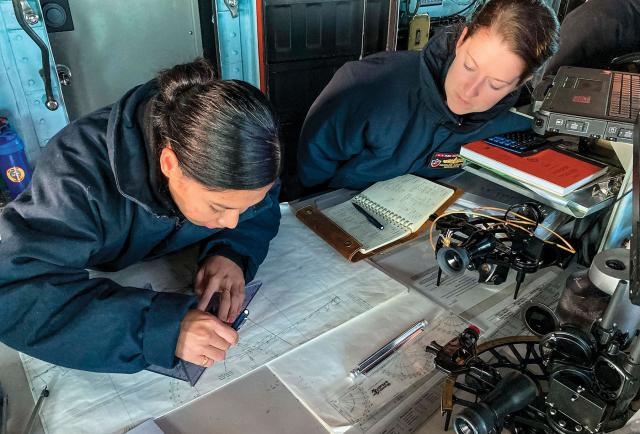
The coauthor, right, and one of her quartermasters on board the USS Essex (LHD-2) plot a course in the ship’s pilothouse.
To ensure the bridge watchstanders could keep a precise and continuous paper plot, Lieutenant Commander Stanton required practice plots during both deployment transoceanic transits (San Diego to Guam, then Japan to Oahu).
U.S. Navy (Walter O’Donnell) 

The Five-Day Exercise

The Navy conducts live-fire weapons drills, damage control drills with real smoke and fire, and exercises hunting real submarines, but it does not regularly practice for emergency, long-term, open-ocean navigation without GPS.
With many vulnerabilities, GPS will likely be the first system an adversary attempts to disrupt during a war. 2 
Captain Fletcher approved this electronics-denied voyage to assess her crew’s navigation capabilities under pressure.

Navy navigators are held to an exacting standard in shiphandling, piloting, seamanship, planning, and ocean sailing.
In addition, navigators juggle many administrative tasks, such as department head and senior watch officer duties and preparations for material and administrative inspections. 3
At the same time, The Surface Ship Navigation Department Organization and Regulations Manual(NavDORM) expects that “ships will be prepared to operate in a PNT [position, navigation, and timing] degraded or denied environment.” 4
But a navigator must be always ready and able to do so.

In 2017, naval training curricula reinstated basic celestial navigation topics, ensuring junior surface warfare officers and quartermasters are oriented to fundamental concepts and vocabulary prior to entering the fleet. 5 
However, mastery of such a complex skill requires dedicated practice at sea.
The Essex’s five-day celestial navigation transit should be a training template for future navigators, junior officers, and quartermasters.

Preparation and Methodology

Prior to deployment, Lieutenant Commander Stanton conducted a celestial navigation training series for junior officers and quartermasters of the watch (QMOWs).
The series moved from theory to practice, culminating in a hands-on sextant exercise from the Essex’s flying bridge.
To ensure the bridge watchstanders could keep a precise and continuous paper plot, Lieutenant Commander Stanton required practice plots during both deployment transoceanic crossings (San Diego to Guam, then Japan to Oahu).
The celestial plots, including a continuous plot of dead reckoning positions, were compared directly to GPS, VMS, and STELLA to hone celestial navigation skills while all sensors were still available.
For maximum training effect and redundancy, two paper celestial plots were always maintained on the bridge: one by the officer of the deck and the junior officer of the deck, and another by the QMOW.

Captain Fletcher reviewed and approved a detailed safety plan that minimized risk at all stages of the exercise.
Lieutenant Commander Stanton planned the voyage on a paper gnomonic chart and in VMS, then the chart petty officer laid the track on position plotting sheets for both the junior officer plot and the QMOW plot.
Lieutenant Commander Stanton reviewed available celestial bodies for the planned latitudes as well as the weather forecast for predicted sky cover percentage.
During the voyage, the only operational VMS nodes (with GPS) would be in the combat information center (CIC) and the chart room.
All other nodes (QMOW table, officer of the deck station, navigator’s stateroom, and VMS repeater in the CO’s cabin) were configured to keep them online for system health, but with the display unavailable to all users.
The chart room node was used exclusively for the QMOW to log the ship’s position per NavDORM requirements.
However, Lieutenant Commander Stanton’s guidance was to look only at the coordinates on the display and keep the view offset.
CIC was to notify Lieutenant Commander Stanton if the Essex deviated more than 10 nautical miles (nm) from the planned track.


A quartermaster on board the Essex plots a course in the pilothouse.
The Essex’s celestial navigation voyage gave the watch officers and quartermasters the opportunity to toil over a paper plot, watching their hand-drawn symbols move from west to east.
U.S. Navy (Brett McMinoway)

The Transit—a Firsthand Account and Impressions

During the five-day, 1,800-nm transit, the navigation team and bridge watchstanders did not use GPS, STELLA, VMS, or any GPS-derived information, including course/speed over ground.
When we obtained two consecutive fixes, we calculated set and drift and course/speed made good.
We used pilot charts (historical weather charts) to help predict expected leeway, set, and drift over the course of the voyage.

We had a steep learning curve on the first day without electronics.
The ship ended up 5 nm off track.
In the Pacific Ocean, a 5-nm track deviation is not navigationally significant; however, it was significant to us because we expected (perhaps unrealistically) immediate precision.
Fortunately, Captain Fletcher continued to trust the team.
For the rest of the voyage, the ship remained within 2 nm of track, and on reaching San Diego, we were consistently plotting within 1 nm of track.

While we expected precision, we had to learn to wait longer and use fewer fixes to achieve it.
We routinely navigated for 12 hours at night without a fix, when celestial navigation is all but impossible without advanced, expensive equipment (i.e., a bubble sextant).
Twice during the voyage, more than 15 hours elapsed between fixes because of cloud cover.
While this length of time may not surprise those who sailed prior to GPS, it is gut-wrenching in today’s Navy after years of easy access to precise, real-time data and communications.
Should maintaining a celestial navigation plot become necessary in the future, bridge watch officers and all who rely on their position data will be required to do what has become unnatural at sea—wait.
Lessons

Advanced, hand-computed celestial navigation is a full-time job.
It required both of us to be on (or near) the bridge for approximately 18 hours a day, especially during the morning and evening star fixes.
Performing sight reduction by hand required approximately three to four hours per day.
Navigators who aspire to conduct a similar voyage may use STELLA to avoid cumbersome hand computations.

The surface warfare junior officers and quartermasters loved this evolution.
No longer able to stare at the VMS screen, they were liberated from the temptation to make micro course adjustments to keep the ship perfectly on the electronic track line.
Not only did this save fuel, but it also gave the watch officers and quartermasters the freedom to enjoy being what they called “real sailors” as they toiled over a paper plot.

Patience and foresight are required.
When a ship configured with GPS and VMS makes a course or speed change, there is immediate feedback.
However, with these systems no longer in play, navigation teams must rely on past solutions to predict future success.
For example, after plotting an evening star fix and obtaining the ship’s position, we calculated set and drift, noted how far left or right of track the ship was, then chose a course to correct our position in relation to track while compensating for observed set and drift.
We were unable to obtain feedback on our decision until after our morning star fix—typically 12 hours later.
Since the length of time between observations is so long, solutions must be minor and meticulously considered.
For example, using the radian rule, steering 1 degree off base course for 12 hours at a speed of 16 knots results in nearly 3.5 nm left or right of track (565 yards per hour).

Most navigators and senior QMs have the training to complete a similar voyage.
Any Surface Navigator/Assistant Navigator Course or QM A School graduate can perform celestial navigation using only STELLA, paper charts, and plotting sheets.
However, while being trained in the competencies of the craft, many navigators and quartermasters do not practice celestial navigation regularly in the fleet.
Despite the fact that since 2015 the NavDORM requires that each ship conduct a celestial navigation Day’s Work in Navigation (DWIN) daily, Mr. O’Donnell has asked more than 1,000 Surface Navigator/Assistant Navigator students if they had done one and fewer than half said they had, with most admitting that celestial navigation is the first part of their jobs they sacrifice to fulfill their administrative duties.
Despite the Chief of Naval Operations’ emphasis on celestial navigation, a culture of using celestial navigation daily has yet to be embraced again in the surface fleet.

Recommendations

Whenever possible, navigators and quartermasters should take the celestial navigation skills they learned in the classroom, practice them at sea, and lead by example.
Use the sextant at least once a day.
Master sunlines first, then planets, stars, and finally the moon.
Earn the commanding officer’s and executive officer’s trust before asking them to embark on a celestial navigation voyage.

Start small and get creative.
Unplug the Defense Advanced GPS Receiver (DAGR) on the emergency navigation laptop.
Manually update the ship’s ENL position using celestial fixes for a few days, with the goal of doing it for a full voyage.
Once acceptable accuracy has been achieved, go the next step and plot on charts and paper plotting sheets.
Varsity-level celestial navigation is a full paper plot with sight reduction done by hand.
This is the most primitive way of navigating, and mastery of it will ensure ships’ navigation teams can endure wartime conditions.

Commanding officers must trust their navigation teams.
COs will set their ship’s safety boundaries during any celestial navigation practice, and navigation teams should be free to grow as they learn within those boundaries.
COs should ensure their navigation teams are completing the DWIN checklist (Appendix K in the NavDORM) every day, as the type commanders require.6 To hold navigation teams accountable, have the navigator submit the previous day’s DWIN checklist with 12 o’clock reports while underway.
COs should take their navigators off the watchbill whenever possible so they can focus on completing and teaching celestial navigation.

Finally, ships should conduct an analog voyage on every extended transit, specifically crossing the Atlantic or Pacific Oceans.
Navigators should be given autonomy and authority to tailor their methods as their teams grow more competent.

If any ship is interested in undertaking a similar voyage, we can send them a training plan and offer distance support as they prepare.
The USS Porter (DDG-78) completed a similar crossing of the Atlantic Ocean in June 2023 after her navigator and senior QM expressed interest.

In the GPS-addicted Navy, an analog voyage over long distances is a novel concept.
But we did it, and other ships can, too.
In wartime operations, they may have no choice.

Links : 


Monday, November 17, 2025

China’s control of submarine cables between NATO nations under scrutiny

CITIC Telecom's Baltic Sea Cable
Fiber
optic cable connecting Estonia, Finland and Sweden

From Newsweek by Brendan Cole and John Feng

A Finnish newspaper has reported growing security concerns in the country over the Chinese ownership of a firm that operates underwater data cables in the Baltic Sea.

Helsingin Sanomat reported that there was increased scrutiny over the Chinese state-owned firm Citic Telecom CPC, through its subsidiaries, owning the three telecommunications cables linking Finland, Estonia, and Sweden.
 
Although there are no allegations of wrongdoing by the firm, the head of Finland’s National Cyber Security Centre told the paper that Beijing's link was of concern because whoever controlled the cable had access to its data traffic.

Sari Arho HavrĆ©n, senior adviser for Business Finland, told Newsweek that as the cables are critical infrastructure, their control by China “is indeed problematic.” 

Why It Matters
 
Finland, the European Union, and the United States have recently raised concerns about Beijing’s links to data cables, citing worries about national security, data integrity, and geopolitical stability over this vital infrastructure for NATO countries.

What To Know


The story by Helsingin Sanomat outlines how Citic Telecom CPC company, through its subsidiaries, owns and operates three Baltic Sea cables that carry information from private individuals, companies, and authorities.

A map by Newsweek illustrates the extent of this network, which comprises three separate routes: one between Finland and Estonia, a second between Finland and Sweden, and a third between Estonia and Sweden. 

Citic Telecom CPC is headquartered in Hong Kong, but its parent company, Citic Group, is owned by the Chinese state and operates under the supervision of China's Ministry of Finance, playing a key role in China’s Digital Silk Road initiative.
This initiative is expanding Chinese tech infrastructure globally.

The three cables in the Baltic Sea are managed by Citic Telecom CPC's subsidiary in Tallinn, according to Helsingin Sanomat, which quoted the company as saying that it operates under EU regulation and fully complies with local laws and regulations.

There was little attention when it acquired the data cables from the Dutch company Linx in 2019, but growing concerns have since emerged over Beijing’s more assertive foreign policy and increased role in the internet cable network. 

In Estonia, Citic’s subsidiary provides services to the Defence Forces, Ministry of Education and Research, and Narva City Administration, the paper said.

Traficom, the Finnish communications agency, has not detected any misuse related to Citic Telecom CPC's data cables in the Baltic Sea.

However, Anssi KƤrkkƤinen, Director General of the National Cyber Security Centre Finland (NCSC-FI) told the outlet that ownership of data cables always involves a risk and as critical infrastructure, whoever controls them has access to their data traffic.

In recent months, the authorities of Finland, the European Union and the United States have raised concerns about data cables owned by Chinese companies.

In 2022, the U.S. banned one of the Citic Group's telecommunications companies from operating in the country, and the European Parliament raised the issue of trade in its resolution on China's cyber threat.

Sari Arho HavrĆ©n, who is also an associate fellow at the Royal United Services Institute (RUSI) told Newsweek Thursday that following accusations of cables being cut and China’s backing for Russia and its war against Ukraine “these hidden risks are attracting more attention."

China's increasing influence over the internet cable network and the potential threats to modern societies and their reliance on these networks are becoming more evident and critical infrastructure; its control by Beijing was problematic, she said. 


The C-Lion1 submarine telecommunications cable being laid at the bottom of the Baltic Sea off the shore of Helsinki, Finland, on October 12, 2015.
(Ph...Read More


What People Are Saying


Anssi KƤrkkƤinen, Director General of the National Cyber Security Centre Finland (NCSC-FI), told Helsingin Sanomat: "From our point of view, all submarine cables are critical infrastructure...whoever controls the cable has access to the data traffic on it, if they so wish."

RUSI Associate Fellow Sari Arho HavrĆ©n told Newsweek: “These cables are critical infrastructure, and their control by China is indeed problematic.” 

What Happens Next

The Chinese firm is not accused of wrongdoing, but scrutiny is likely to remain over China's Digital Silk Road Initiative.
Reuters reported in July that the U.S. plans for new regulations that would more extensively ban the use of Chinese technology in data cables and limit the granting of new licenses to Chinese cable companies.

Sunday, November 16, 2025

Whales cemetery in Yanrakynnot Chukotka (Russia) honors the spirits of whales


Links :