With marine life and ecosystems facing a rising tide of threats, the ocean exploration community needs nimble, cost-effective tools for measuring and monitoring ocean health.
MBARI's Control, Modeling, and Perception of Autonomous Systems Laboratory, known as the CoMPAS Lab is up to the challenge.
MBARI scientists and engineers build and adapt advanced technology that enhances ocean data collection.
Led by engineer Giancarlo Troni, the CoMPAS Lab team develops scalable marine technology that can easily be modified for use in a wide variety of vehicles and platforms.
Working with other teams across MBARI, the CoMPAS Lab leverages vehicles like the MiniROV to deploy and test new tools in Monterey Bay's submarine canyon and then adapt them for other mobile platforms.
By sharing open-source design specifications and advanced algorithms with the wider ocean exploration community, we hope to expand access to MBARI’s engineering innovations.
MBARI technology is transforming what we know about the ocean and its inhabitants.
Our scientists, engineers, and marine operations staff work together to create innovative tools for a more sustainable future where autonomous robots and artificial intelligence can track ocean health in real time and help us visualize ocean animals and environments.
Studying our blue backyard is revealing our connection to the ocean—how it sustains us and how our actions on land may be threatening its future.
Figure 1: Most historic maps were created as artworks for the public. This
world map from 1635 is a beautiful example of the craftsmanship that
went into the making of such maps, as well as the inaccuracies and
assumptions presented.
How early explorers and cartographers documented the world without satellite GPS
Ever since the Age of Exploration, surveying has played a crucial role in the mapping of our world. This article delves into the captivating history of surveying at a time when GPS did not exist. When early explorers set sail to discover new lands, which surveying techniques were used and which challenges were overcome to help them navigate unfamiliar territories and create detailed maps?
Early explorers faced numerous challenges in their expeditions – from diseases to mutinies – and they had to tackle them without modern technologies that we often take for granted today. Navigation and mapping were particularly arduous tasks, relying heavily on rudimentary instruments, celestial navigation and dead reckoning. One of the primary challenges was to determine precise locations. Without GPS, explorers had to use tools like astrolabes, sextants and compasses to determine their position using the sun and stars. This method was heavily dependent on two factors: clear skies and a highly skilled navigator.
In the 1500s, determining the time of day was one of the main challenges that came with navigation, making it difficult to effectively determine longitude. Consequently, longitudes were often broad guesses, leading to inaccuracies in charts and therefore navigational errors. This challenge persisted until the creation of the marine chronometer in the 18thcentury.
Early cartography was an art form. Cartographers translated explorers’ accounts of their travels into stunning images, often intended for publication in books and newspapers to inform the general population of the adventures. However, the harsh conditions and challenges faced by the explorers who provided the input meant that many of these maps were inaccurate and often speculative.
Early surveying techniques
The Age of Exploration (from the late 15th century to the 17th century) marked a significant period in history when continents united, and Europeans established routes to previously unknown worlds. One of the main motives for these expeditions was the establishment of new trade routes, which meant that accurate mapping and surveying became essential for success.
One of the first and most crucial tools used by early explorers was the compass. This provided a raw sense of direction, which had proven crucial in explorative navigation. To measure angles, explorers used instruments like astrolabes and cross-staffs. Astrolabes, dating back to ancient times, were useful for determining the altitude of celestial bodies. By measuring the angle between the horizon and the sun or stars, explorers could estimate their latitude. Cross-staffs were used to measure angles between distant objects on land, aiding in the creation of basic maps and charts.
Triangulation also played a key role in early surveying. Explorers and surveyors would establish a baseline between two points and then measure the angles to a third point from each end of the baseline. By applying trigonometric calculations, they could accurately determine the distances and positions of unknown points relative to the baseline. This process was repeated across vast areas to create a network of interconnected triangles, allowing for the accurate mapping of landscapes and coastlines. Triangulation provided a systematic and reliable method for surveyors to gather data and create detailed maps, enabling explorers to effectively communicate the raw characteristics of the terrain back to their countries.
Figure 2: The iconic sextant was a staple of navigation in the Age of Discovery, providing a means to determine longitude and latitude.
Technological advancements
During the Age of Enlightenment (in the 17th and 18th centuries), the field of surveying experienced a series of developments that enhanced the precision and efficiency of cartography and navigation. One of the most notable innovations was the enhancement of the theodolite, which evolved from simpler devices like the plane circle. Originating from the work of the well-known 16th-century English mathematician and surveyor Leonard Digges, who described it as the “instrumentum topographicum”, the theodolite was perfected during the Enlightenment to measure angles with high precision in both horizontal and vertical planes. The theodolite is equipped with a telescopic sight for targeting, and graduated circles for angle measurement, allowing for the precise determination of distances and elevations. The integration of clamps and slow-motion screws further improved the theodolite’s functionality, enabling fine adjustments and stable angle measurements. The improvements gradually made the instrument more practical and efficient for navigators and surveyors to take with them in their expeditions.
Another critical advancement was the widespread adoption of the sextant. The sextant’s design was improved with a movable arm (the index arm) and a scale (the arc) graduated to fractions of a degree. This provided navigators with a reliable means of determining their position, even in adverse weather conditions.
Like today, levels were an integral part of the surveyor’s toolkit, serving to establish horizontal lines and ensure accuracy in measurements. These devices consisted of a spirit level that housed a liquid-filled tube with an air bubble, with a level surface indicated by the bubble in the centre of the tube. Surveyors would position the level at various points along their surveying route, carefully adjusting its orientation to account for any slopes or variations in the terrain. By using levels in conjunction with other instruments, such as theodolites and chains, surveyors could create a consistent reference line for their measurements. The surveyor would position the level at a known point and align it horizontally, from which angles and height differences could be determined.
The Age of Enlightenment also saw significant advancements in the methodologies of triangulation and geodesy. Geodesists engaged in determining the Earth’s exact shape and size, which was vital for the development of accurate map projections and for understanding the planet’s physical characteristics. The efforts to resolve the debate between the Newtonians and the Cassinians over the Earth’s shape, through expeditions like the ones to Lapland and Peru, exemplify the period’s dedication to empirical, geodetic research.
These technological and methodological advancements during the Age of Enlightenment had a profound and lasting impact on the field of surveying. The period’s contributions to surveying laid the foundations for future developments (many of which did not occur until the 20th century), setting the stage for modern practices. As a result, today’s surveyors can depend on detailed and accurate maps that form the basis of contemporary navigation and geographic information systems (GIS), and continue to shape our understanding of the world’s geography.
Figure 3: Created in 1727, this beautiful map of Japan shows the distorted visualization of what we now know to be the true shape of the current island.
The life of a surveyor in the 1700s
Equipped with essential tools and a thirst for discovery, countless surveyors set out to map uncharted territories in the 1700s. In the days before satellite and GPS, these were the techniques and instruments they used:
The sextant
First, to establish their current position, surveyors used a sextant to measure the angle between a celestial object (like the sun or a star) and the horizon. This enabled them to calculate their latitude and longitude.
Reference points and theodolites
Next, the surveyors focused on establishing reference points. They employed a theodolite (a telescope mounted on a tripod) to measure both horizontal and vertical angles. By sighting reference points and noting their angles, they created a network of interconnected points. These reference points formed the foundation for their survey work.
Gunter’s chain
Surveyors ventured into the field armed with a metal chain. The so-called Gunter’s chain was exactly 22 yards (approx. 20m) long with 100 links. This gave the measuring of distances an element of consistency, besides being more reliable and durable than rope. Distances between the reference points created with the theodolite were accurately measured and documented.
Levels for precision
To account for slopes and uneven terrain, surveyors used levels. The levels were then often used with other instruments to gauge height differences over longer distances. By taking readings with the level, they adjusted measurements to ensure the highest possible accuracy.
Figure 4: Antarctica long remained one of the last mysteries on the world map, both due to its inaccessibility and its low profitability for explorers.
Conclusion
The exploration and mapping of the unknown world during the Age of Exploration was a remarkable feat accomplished by early explorers despite numerous challenges. The absence of modern technologies such as GPS, accurate timekeeping, reliable maps, and instant communication made their journeys incredibly perilous. They relied on basic tools and instruments like compasses, astrolabes and cross-staffs to aid their surveying efforts. As the Age of Enlightenment brought technological advancements such as the refinement of the theodolite, adoption of the sextant and progress in triangulation and geodesy, it revolutionized surveying and enhanced the accuracy of mapping. The legacy of these early explorers and their technological advancements is evident in the detailed and accurate maps we depend on today.
Surveying timeline
Technological advancements throughout the centuries have transformed surveying from a manual, labour-intensive process into a highly precise and efficient field that leverages electronic and satellite technology. Today’s surveyors can achieve levels of accuracy and efficiency that were unimaginable in the past, and the industry continues to evolve with ongoing technological innovations.
12th century: First use of the magnetic compass in mining surveying in Harz, Germany.
16th century: The plane table was invented by Gemma Frisius around 1530, and became widely known through J. Praetonius in the late 16th century.
17th century: Instruments like quadrants and astrolabiums, used for angle measurements, were notably improved by Snellius (in 1615) and Picard (in 1669-70).
Picard also introduced telescopic sights allowing for more accurate angle measurements.
18th and 19th centuries: After evolving from earlier instruments, significant improvements were made to theodolites, including the introduction of telescopic sights and more precise angle measurement.
1947: Development of the geodimeter, an electronic distance measurement (EDM) instrument that used light waves to measure distances accurately over long ranges.
1957: Development of the tellurometer, another EDM device that used microwaves for distance measurement, further changing surveying from triangulation to trilateration.
1970s: This decade saw a number of key developments, including:The electronic tacheometer, an instrument that combined the functions of a theodolite and an EDM, allowing for rapid measurements of angles and distances.
Doppler satellite receivers, which utilized the Doppler effect from satellites to determine positions on Earth, enhancing the accuracy of location-based measurements. Inertial surveying systems, which used gyroscopes and accelerometers to determine position without the need for external references (particularly useful in areas without clear sightlines). The launch of the first global positioning system (GPS) satellite in 1978 marked the beginning of satellite-based positioning, which has revolutionized surveying by providing precise location data anywhere on Earth.
A print showing the Goliath and the HMS Widgeon, repurposed
tugboats, in 1850 laying the world’s first submarine communications
cable between Dover in the United Kingdom and Calais in France. Now, 175
years later, undersea cables are still highly important, and
vulnerable.
Increasingly frequent incidents of deliberate underwater sabotage targeting critical fiber optics, power cables and pipelines raise significant global security concerns.
NATO members’ hesitance to respond emboldens adversaries
Undersea attacks threaten global connectivity, economics and security
In the early hours of November 19, an underwater fiber-optic cable for high-speed internet traffic between Finland and Germany in the Baltic Sea was cut in Swedish waters. According to the Finnish company Cinia Oy, which owns the 1,200-kilometer cable, all its connections went down. Just hours later, a similar cable between Sweden and Lithuania was also severed.
Investigators from Finland, Sweden and Lithuania launched a criminal investigation, suspecting that a passing ship had intentionally cut the cable by dragging its anchor along the seabed. Commenting on the event, the German minister of defense, Boris Pistorius, explicitly said it was a case of deliberate sabotage. Matters heated up when evidence from Swedish maritime surveillance showed that the Chinese cargo vessel Yi Peng 3 had passed both points when the breaks occurred.
Immediately after the incident, the vessel, otherwise en route to Egypt from the Russian port of Ust-Luga, attempted to leave the Baltic Sea and moved into the strait between Sweden and Denmark. There it was intercepted by Danish Navy and Coast Guard vessels. Refusing demands that it move into Swedish territorial waters, where Swedish authorities would have jurisdiction, the ship dropped anchor in international waters. It remained there, surrounded by naval vessels from several countries, while diplomatic negotiations took place for several weeks. China allowed European investigators, accompanied by Chinese officials, to board the Yi Peng 3 on December 19. Two days later, the ship resumed its voyage.
This was not the first time a Chinese vessel had been involved in such activity.
This was not the first time a Chinese vessel had been involved in such activity. In October 2023, the Hong Kong-flagged container ship Newnew Polar Bear was suspected of damaging two underwater fiber-optic cables and a gas pipeline, the Balticconnector, between Finland and Estonia. Ignoring calls from Finnish and Estonian authorities to stop, the vessel continued its journey and eventually reached the Port of Tianjin in China via the Russian Northern Sea Route.
At a press conference following the 2023 event, Finnish investigators presented evidence of a trail up to 4 meters wide on the seabed left by an anchor that was dragged to the pipeline that then ruptured. The investigators also shared evidence of the Chinese vessel missing one anchor. Faced with these findings, the Chinese government admitted guilt but claimed it had been an accident.
Although NATO had warned European lawmakers about the dangers of sabotage against underwater assets critical to the continent, states generally refrained from acting. As a result, the situation remained little changed through the end of 2024. However, a rude Christmas awakening was in store.
The MV Eagle S tanker, which damaged undersea cables in the Baltic Sea in Dec. 2024, detained off the coast of Porvoo, Finland, on Jan. 9, 2025. Finnish authorities deemed the tanker, part of the “shadow fleet” carrying sanctioned Russian oil, as not seaworthy after inspections onboard.
On December 25, 2024, still more undersea cables in the Baltic were cut, this time connecting Finland and Estonia in addition to a cable linking Finland and Germany. Authorities identified the Russian-linked oil tanker Eagle S, which traversed the area of the cuts at the time of the outages, as the culprit. This time, Finnish authorities delivered a more proactive response than in past Baltic Sea sabotage incidents, deploying military forces that boarded the ship from a helicopter, assumed control of the vessel and forced it into Finnish waters. Investigations have documented that the vessel had dragged its anchor for dozens of kilometers and was on the verge of sabotaging another cable when it was intercepted.
In the first week of January 2025, a Chinese-owned vessel cut an undersea fiber-optic cable near Taiwan in yet another apparent act of sabotage, according to Taiwanese authorities.
On January 26, an undersea fiber-optic cable between Latvia and Sweden was compromised; Sweden has opened an investigation into likely sabotage and has seized control of the suspect vessel.
Enough is enough for NATO
Only after a clear pattern of sabotage emerged have European nations finally initiated some preventative measures.
The Estonian Navy in early January stepped up maritime patrols in the Baltic, looking for ships with anchors missing or trailing cables. In mid-January NATO Secretary General Mark Rutte announced “Baltic Sentry,” a mission to increase the surveillance of the Baltic Sea using ships, aircraft and drones.
In late January, authorities in the United Kingdom announced that they had been tracking suspicious movements of a Russian vessel, the Yantar, which was in British waters last year and had recently returned. They said the Russian vessel was mapping out British undersea critical infrastructure. In a joint statement, UK and American officials said that Moscow was waging a “reckless campaign of sabotage” across Europe.
London has deployed aircraft, seaborne and underwater assets and changed its rules of engagement to allow Royal Navy ships to move closer to suspect vessels. The UK even surfaced a nuclear submarine in close proximity to the Russian ship as a warning, and has also boosted surveillance of its waters and joined in preemptive NATO measures in the Baltic.
The most immediate question concerns why China allows itself to be involved in actions with few obvious upsides but potentially severe downsides. Being implicated in acts of pure sabotage will not help improve commercial relations with Europe or nations in the Far East at the moment when Beijing is grappling with an economic downturn and a looming trade war with the United States. A likely answer is that, in the Baltic cases at least, it serves as a form of quid pro quo. Given that China depends on transport along the Russian-controlled Northern Sea Route, Beijing may have felt it needed to lend a helping hand to Moscow. The situation near Taiwan appears to be Beijing’s way of highlighting the vulnerability of the island that it claims to be its own.
Given that China depends on transport along the Russian-controlled Northern Sea Route, Beijing may have felt it needed to lend a helping hand to Moscow.
Allegations that the Yi Peng 3 captain is a Russian citizen support this interpretation, as do intelligence sources cited by The Wall Street Journal, which claim that he received direct instructions from Russian intelligence. A more sinister possibility is that Beijing is simply gaining experience to use in a heightened confrontation over Taiwan.
Turning to the question of why Russia is engaging in such activities, the obvious answer is that it is simply testing the limits of what it can get away with. The two incidents involving Chinese vessels fit well into a prior pattern where Russian trawlers have been involved in similar practices of cutting underwater cables by dragging anchors along the seabed. In April 2021 and again in January 2022, cables linking the strategically located Norwegian archipelago of Svalbard with the Norwegian mainland were cut. Although Russian fishing vessels could be shown to have made numerous passes over the areas in question, no action was taken.
These incidents are part of a broader pattern of what is often described as Russian “hybrid warfare” against NATO. On December 12, the U.S. Helsinki Commission, an American government organization, released a report about a Russian “shadow war on NATO,” intended “to destabilize, distress and deter the transatlantic alliance from its staunch support of Ukrainian sovereignty.” It identified four categories of hybrid operations: critical infrastructure attacks, violence campaigns, weaponized migration, and election interference and information campaigns. The report included a map of Europe, where red dots marked each of about 150 different operations. The map appeared as if Europe had come down with a case of measles.
The situation near Taiwan appears to be Beijing’s way of highlighting the vulnerability of the island it claims as its own.
Although there has been ample cause for European governments to voice concern over the recent spate of sabotage against civilian and military industries, unknown drones flying over military installations and even an incendiary device found on a DHL flight in Germany, there are compelling reasons to regard attacks on critical underwater infrastructure as a unique issue.
One reason is that such infrastructure is notoriously difficult to protect. Another is that actions can be taken with a fair degree of plausible deniability. A third is that quite substantial damage may be caused.
A case in point is the sabotage of the Nord Stream pipelines in the Baltic, which had massive consequences for European energy supply and intra-European discussions on managing relations with Russia. Although the matter has been surrounded by substantial controversy and finger-pointing, it is significant that it has still not been possible to achieve clarity concerning culpability.
A more sinister possibility is that Beijing is simply gaining experience to use in a heightened confrontation over Taiwan.
Returning to the case of Russian motivations for waging a hybrid war against NATO, the main question concerns the escalation ladder. Assuming that NATO will not be ready to play hardball until there is substantial kinetic escalation, the Russian strategy is finely tuned to stay just short of the level where retaliation is bound to follow. Attacks on fiber-optic cables present an excellent illustration. While breaks may be swiftly repaired, reducing the immediate harm, such incidents offer the Russian side ample input for learning about the scope of the damage, response times and political fallout.
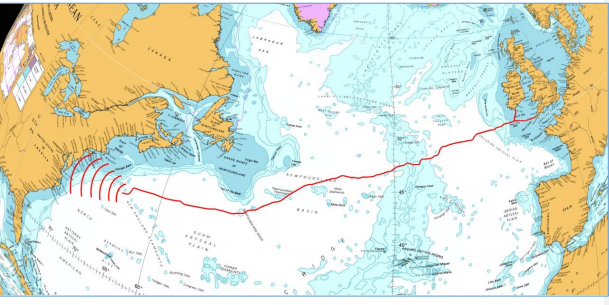
Kingfisher database undersea cables for the Baltic in the GeoGarage platform (Google Earth view)
Likely targets of future malign Russian and Chinese actions
Although further Russian escalation in the form of attacks on land is possible and likely, the main playing field will remain on the seafloor. In principle, this is nothing new. During the Cold War, both Russia and America were busy creating their own underwater infrastructure for communications and early warning. One may safely assume that both sides had ample information about where the opponent deployed its assets and detailed plans for sabotage.
The main difference between those games and the events currently unfolding lies in the knowledge that interference with Cold War underwater infrastructure would have been fraught with great danger. As it could have been perceived as the first stage of a major war, it was either not done or done with great care. In the present day, Russia is blatantly and deliberately pushing the envelope and is learning along the way. Moscow is only able to do so because it is presented with a target-rich environment and little resistance.
The network of oil and gas pipelines rolled out on the North Sea’s seabed is enormous and impossible to protect in its entirety. To this may be added the ongoing construction of large offshore wind farms, designed to account for a substantial share of European energy generation.
While attacks on pipelines may cause considerable economic damage, interconnectors will ensure that damage to the energy system can be limited. The same goes for attacks on power lines from offshore wind farms. Temporary power outages will be costly, but systems are designed to manage such incidents.
The network of fiber-optic cables is different in that while pipelines and power lines are mainly regional, fiber-optic cables are a global concern, extending across the oceans. For example, the severed cable near Taiwan extended to the U.S. A concerted attack on undersea fiber-optic infrastructure could destabilize targeted societies, paralyze payment systems and cause mayhem in financial markets that depend on instant information flows. The question of vulnerability must be viewed against this background.
An additional danger in allowing Russia or China to escalate the game of hybrid attacks lies in proliferation. If rogue states accumulate knowledge on how to attack critical underwater infrastructure, as well as where and what reprisal to expect, if any, it could unleash a major escalation. This might result in damage much broader than that caused by Houthi rebels firing low-quality missiles in the Red Sea.
The prospect of a massive attack on global internet connectivity is truly frightening, especially as both Russia and China are pursuing revanchist agendas and seeking to create a new world order. Moreover, in contrast to the dangers of a global thermonuclear war, few safeguards are in place when it comes to undersea infrastructure. Even a common understanding of what the problem looks like is absent.
Scenarios
Likely: Hybrid attacks continue
One possible scenario is based on continuity, assuming that Russia (and China or any other malign actor) is allowed to get away with steadily more egregious provocations. The danger is that with every iteration, governments and populations in targeted countries grow accustomed to hybrid attacks and start seeing them as somehow “normal.” Meanwhile, the Kremlin observes and learns how to fine-tune further escalation.
Given that Russia will continue to push until it is stopped, the core question must concern how far it can go with its provocations, and how high the stakes will be allowed to rise, before NATO decides that responses must escalate from mere words to practical action and more robust measures.
Precedent boosts the likelihood of more of the same. Although the escalation of Russian hybrid attacks has been ongoing for some time, and NATO has had ample latitude to strike back, little has been done beyond observation, condemnation and the recently announced Baltic Sentry mission.
One example is Russia’s “shadow fleet” of old tankers, which it uses with impunity to circumvent sanctions on its oil exports. Aggressive controls and lengthy detentions of these ships could easily be combined with harsh measures against the Greek shipping magnates who provided them.
Another example is the Russian practice of jamming global positioning system (GPS) signals, which presents serious dangers to civilian aviation. In 2024, Russia disrupted air traffic with this tactic. Given that the jammer has been localized to the Kaliningrad exclave, it could be easily dealt with via a massive hacker attack to disrupt the jammer and overall internet traffic in the oblast.
A third is the “research vessels” involved in mapping underwater infrastructure in the North Sea and around the British Isles. Although they have been loitering in critical locations with their transponders turned off, little has been done. A determined NATO push to stop such activities could range from “accidental” ramming in thick fog to electronic measures and even sabotage against rudders.
The obvious reason why little has been done is that even limited actions from Russia, which could be undertaken with plausible deniability, have been considered by many to be dangerously escalatory.
Given that about 70 percent of Russian oil exports pass through the Baltic Sea, a determined push from NATO to support Finland and Estonia in disrupting the shadow fleet could have serious consequences. Finland has upped the ante by stating that no icebreaker assistance will be provided to such vessels. The current standoff provides a critical test of NATO resolve. Yet, although Nordic steadfastness may result in major losses in Russian export revenue, it is only part of the picture.
Possible: NATO states move decisively against underwater sabotage
The scenario of NATO finally deciding to firmly push back departs from the assumption that the ultimate Russian objective is to test at what point NATO will trigger its Article 5 on common defense. Given that such an outcome could result in a major confrontation, continued Western indecisiveness makes it unlikely that Russia will desist any time soon.
Consequently, barring any changes, more spectacular attacks are likely to follow. This trend may eventually lead to cross-border provocations against smaller NATO members. Although limited at first, such provocations may escalate to the level of “little green men” crossing borders to support local insurgencies.
There will come a time when NATO will be forced to push back, and in fact, we may be witnessing that now based on recent activities in the Baltic and around the UK. But if NATO states continue to dawdle, the alliance will face irrelevance. Already, some threatened European governments and their leaders, such as Prime Minister Robert Fico of Slovakia, are scrambling to make deals with Moscow. When that sustained point of determined action will arrive in earnest, however, is uncertain. Meanwhile, as the showdown is pushed further into the future, the danger of rogue states engaging in hybrid attacks will rise, and China is watching and learning.
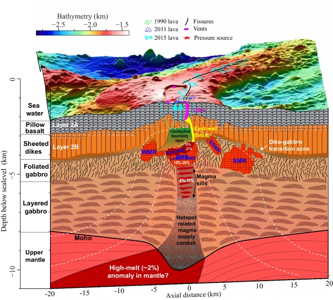
Scientists have warned that an underwater volcano off the coast of the northwestern US is likely to blow sometime in 2025.
The volcano, called Axial Seamount, is more than 3,600-feet-tall and sits half a mile underwater just 300 miles off the coast of Oregon.
Localization with the GeoGarage platform (NOAA raster chart)
Experts made the prediction on December 10 after detecting seafloor swelling around Axial that mimicked a level seen immediately before an eruption in 2015. Seismic activity has also increased, with hundreds of earthquakes generated around the volcano per day and earthquake swarms greater than 500 per day. 'Based on the current trends, and the assumption that Axial will be primed to erupt when it reaches the 2015 inflation threshold, our current eruption forecast window is between now (July 2024) and the end of 2025,' researchers said in the new study. The team first noticed the swelling in November using a suite of tools to meticulously monitor this volcano's activity, collecting real-time data about its rumbling, shaking, swelling and even tilting. Located on the Juan de Fuca ridge, Axial is the most active underwater volcano in the northeast Pacific. Because Axial erupts with some regularity, it provides a unique opportunity for scientists to study the warning signs leading up to an eruption, and learn how to forecast one.
Scientists have warned that an underwater volcano off the coast of the northwestern US is likely to blow sometime in 2025
Experts made the prediction on December 10 after detecting seafloor swelling around Axial that mimicked a level seen immediately before an eruption in 2015 Fortunately, eruptions from Axial pose little threat to people and infrastructure on the West Coast. That's largely because it is a shield volcano, which generally do not have very explosive eruptions. What's more, the seismic activity around it is too minimal to cause a tsunami or a major earthquake.
Oregon State University geophysicist William Chadwick started investigating the volcano in November when he noticed its surface had swelled to nearly the same height it reached before its last eruption nearly 10 years ago. Surface swelling is a strong indication that a shield volcano is about to blow, because it means magma has accumulated underground and is building pressure. The swelling that occurred prior to the 2015 eruption allowed Chadwick and his colleagues to predict that event. It was their 'best forecasting success,' he told Science News. Since the last eruption, Axial has re-inflated to more than 95 percent of its last pre-eruption threshold, Chadwick and his colleagues explained in a statement.
Because Axial erupts with some regularity, it provides a unique opportunity for scientists to study the warning signs leading up to an eruption, and learn how to forecast one
This swelling hasn't been constant.
The rate of inflation slowed between 2015 and 2023, and by the summer of 2023 it nearly stalled out. Simultaneously, the rate of seismic activity remained relatively low during this time. But starting in the fall of 2023, and especially since January 2024, both the volcano's swelling and seismic activity have been gradually increasing, 'apparently signaling a fundamental change in the magma supply to the volcano,' the researchers explained. By July 2024, the rate of swelling had increased to roughly 10 inches per year and was still growing. 'If the rate of inflation and seismicity continue to increase, an eruption may be likely before the end of 2024,' the team shared.
The ability to forecast an eruption event more than 24 hours ahead is 'pretty unique,' let alone providing months of advanced notice, Chadwick told Science News. But the massive research effort surrounding Axial has allowed researchers to dive deeper into the mechanisms driving undersea volcanic eruptions than ever before. They have even developed a new tool that can estimate the magma burst that will set off the next eruption. Others have used artificial intelligence to dig through earthquake records prior to the 2015 eruption and learn more about the imminent warning signs.
Even though Axial is not a particularly dangerous undersea volcano, the forecasting capabilities scientists have gained from studying it could help them predict eruptions from those that are. For example, in January 2022, an extremely powerful eruption of the Hunga underwater volcano in the Tonga archipelago in the southern Pacific Ocean triggered a tsunami that caused an estimated $90 billion in damages. This massive wave impacted California, Hawaii, and parts of Canada, Chile, Fiji, Japan, New Zealand, Mexico and Peru. The West Coast won't have to worry about Axial causing an event like that. But its imminent eruption will provide yet another opportunity for scientists to learn about how these powerful geological structures work.
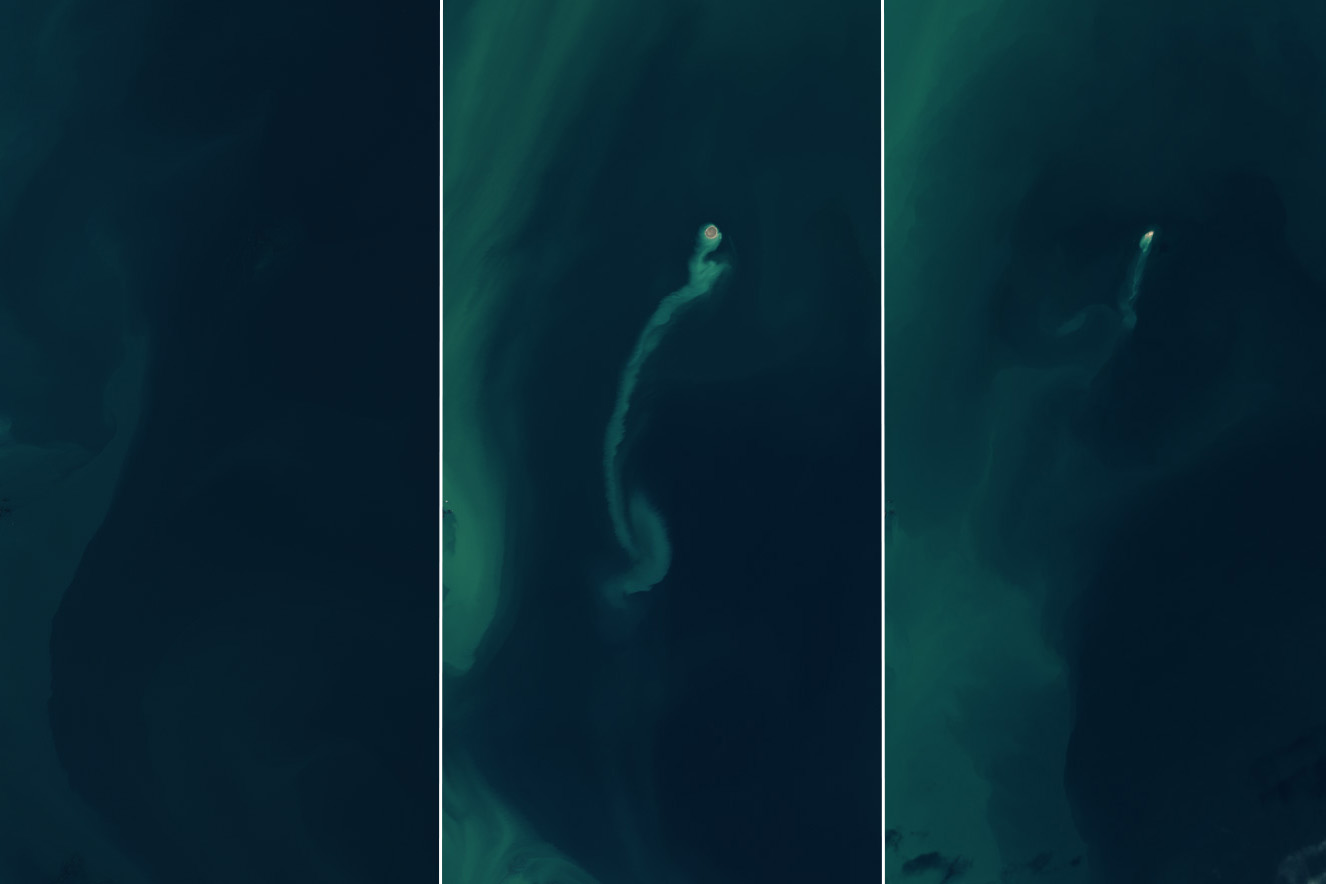
An island emerged from the Caspian Sea after a mud volcano erupted in early 2023.
By the end of the following year, it had nearly eroded away, retreating from view like an apparition. Powerful eruptions of the Kumani Bank mud volcano have produced similar transient islands several times since its first recorded eruption in 1861. Also known as Chigil-Deniz, the feature is located about 25 kilometers (15 miles) off the eastern coast of Azerbaijan.
The OLI (Operational Land Imager) and OLI-2 on the Landsat 8 and 9 satellites captured these images showing the island emerge and shrink. In November 2022 (left), the crest of the volcano remained below the sea surface. By February 14, 2023 (middle), an island had appeared, and a sediment plume drifted away from it. Additional satellite observations suggest the island emerged between January 30 and February 4 and measured approximately 400 meters (1,300 feet) across, said University of Adelaide geologist Mark Tingay. By the end of 2024 (right), a greatly diminished portion of Kumani Bank was visible above the water.
Kumani Bank’s previous eight recorded eruptions occurred in bursts lasting less than two days and produced islands of different sizes and longevities. A May 1861 event resulted in an island just 87 meters (285 feet) across and 3.5 meters (11.5 feet) above the water. This one eroded away by early 1862. The strongest eruption, in 1950, produced an island 700 meters (2,300 feet) across and 6 meters (20 feet) high.
Mud volcanoes are “weird and wonderful features that remain largely understudied and little understood,” said Tingay in a seminar for the Geological Society of Australia. Ranging in size from a couple of meters to several kilometers across, most are found in areas with active tectonics or high sedimentation rates. These are places where subsurface pressure can build and force a mix of fluids, gases, and sediments to the surface. And these features may not be unique to this planet; scientists think that some muddy mounds in the northern lowlands of Mars may have formed when gas- and liquid-rich sediments spewed out to the surface.
February 14, 2023
On Earth, Azerbaijan is unusual for its high concentration of mud volcanoes. Geologists have tallied more than 300 in eastern Azerbaijan and offshore in the Caspian Sea, with most of those occurring on land.
The region falls within a convergence zone where the Arabian and Eurasian tectonic plates are colliding.
Mud volcano eruptions can be hazardous, with the potential to expel large amounts of material—and even flames—over a short period of time. Azerbaijan’s mud volcanoes are linked to the South Caspian Basin’s vast hydrocarbon system and are known to emit flammable gases such as methane along with the characteristic muddy slurries. It is uncertain if the 2023 Kumani Bank eruption was fiery, but past eruptions of this and other nearby mud volcanoes have sent towers of flame hundreds of meters into the air.
After a pastor took a group of Flat Earthers to Antarctica to prove definitively what shape our planet is, some of the truthers were startled to find that the globe is indeed round.
"Flat-Earthers can be found all over the Globe" Etienne Klein
His mission: to prove that there are no barriers — literal or figurative — to prevent them from visiting, but also that the Sun shines there 24 hours a day in the summer — something that simply couldn't happen if the planet was actually flat. "I created The Final Experiment to end this debate, once and for all," Duffy said in a press release ahead of the trip. "
After we go to Antarctica, no one has to waste any more time debating the shape of the Earth."
In a video from that voyage, Flat Earth influencer Jeran Campanella admitted that when it comes to the midnight Sun, he may have been mistaken. "Sometimes you are wrong in life," Campanella said.
"I thought there was no 24-hour Sun. In fact, I was pretty sure of it."
Sun Says
Upon witnessing the round-the-clock sunlight during the Arctic summer, which is opposite ours in the Northern Hemisphere, the Flat Earth enthusiast professed that when it comes to the Sun's movements, so-called "Globe Earthers" are right. "I realize that I'll be called a shill for just saying that and you know what, if you're a shill for being honest so be it — I honestly believed there was no 24-hour Sun," Campanella said. "I honestly now believe there is."
While the trip did seem to persuade at least one prominent Flat Earther that his beliefs were wrong, another of the conspiracy-theorizing Arctic voyagers was less convinced. "I have seen a physical demonstration that could show this working, but I do think that some of the data we're going to have from this trip will help to clarify if that is what's actually happening," Flat Earther Austin Whitsitt said.
As for Duffy, the surprising voice for science behind the expedition, he just seemed glad that he and his motley crew of explorers made it all the way down to the South Pole in one piece.
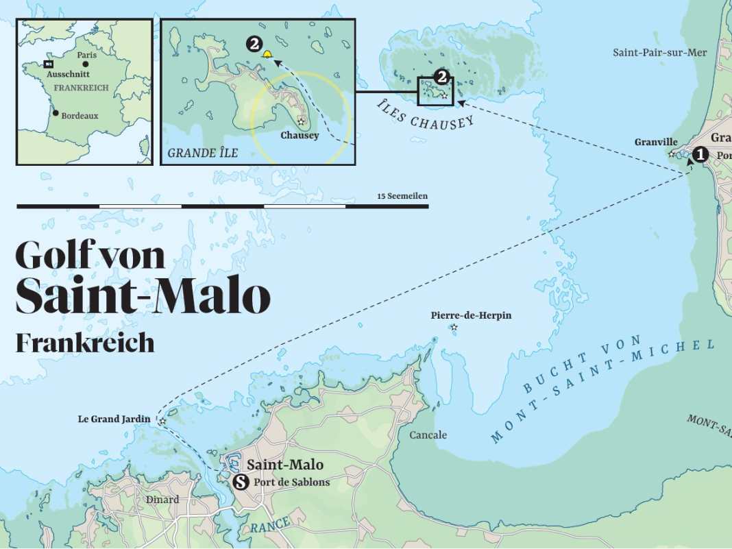
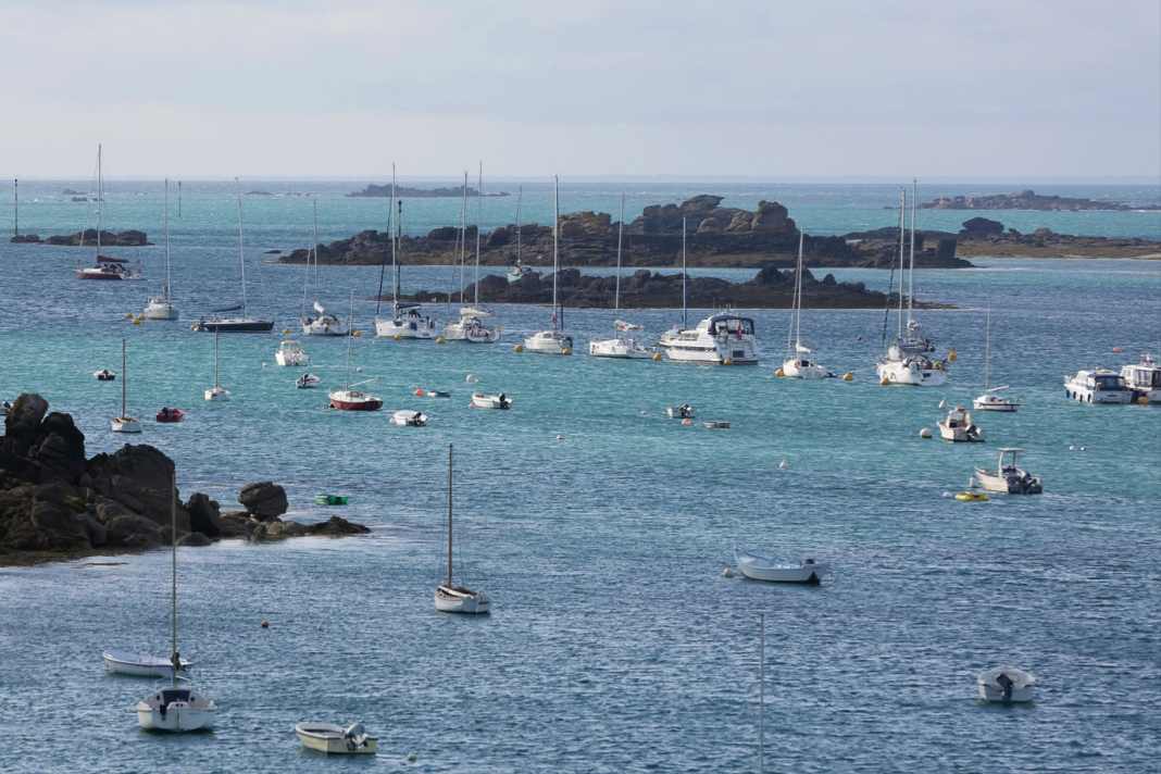
From the Gulf of Saint-Malo, we cross the English Channel to England. Our actual destination is the Channel Islands. We start with the only French archipelago - the Îles Chausey.
The old town centre of Saint-Malo has an unusual Latin name: Intra Muros - within the walls. And indeed, from the outside it looks like a single fortress when you stand at its feet: grey stone that stretches up over the linear house facades behind it to the massive chimneys, which themselves look like crenellated towers.
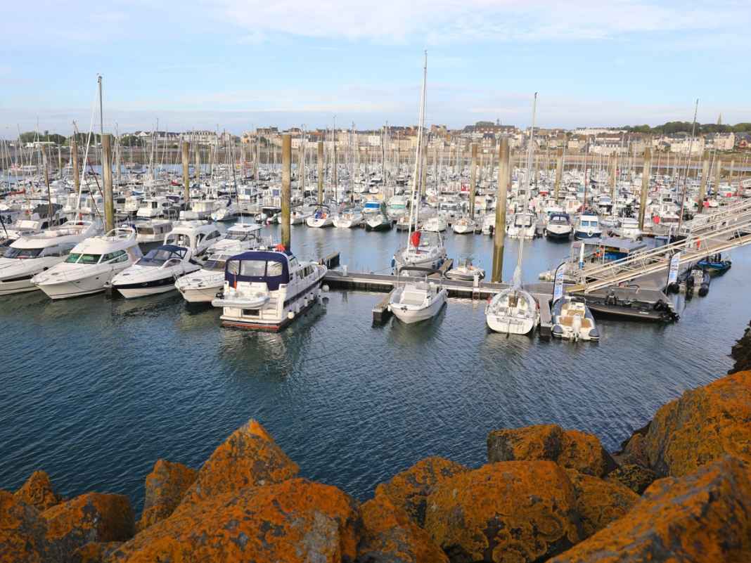
Marina of Saint-Malo in the Port de Sablons
This is where Vauban, the legendary fortress builder of the Sun King Louis XIV, ran riot to protect the harbour of the Breton buccaneer town from the revenge of the robbers. But that's not all: forts were also built on the surrounding tidal islands, whose cannons could fire on all sea routes to the harbour. Saint-Malo is not only surrounded by its walls, but also by the sea on three sides.
Pier head with sea mark, Saint-Malo in the background
Saint-Malo: city of walls, home of the buccaneers
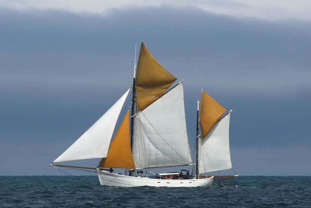
You enter through the Porte de Dinan with its massive twin towers. Directly behind it is the home of the legendary corsair Robert Surcouf, who repeatedly inflicted spectacular damage on the English during the Napoleonic Wars. Even though the Royal Navy won the battle of the fleets, it was unable to get hold of the cunning captain with the letter of marque: Surcouf was able to raise or sink almost 50 ships, more than just painful pinpricks for the pride of the British Admiralty - and the wallets of the British shipowners entrusted with their protection.
The walk over the battlements of the city wall is truly impressive, even if it is peaceful all around. White sails between the islands, fast ferries and pleasure craft, a gaff-rigged sloop with a long bowsprit that could have come straight from Surcouf's time. Below, in front of the wall, the beaches, dotted with parasols, and again and again rocks, sharp-edged, interspersed with small pools left behind by the draining water. The walls of the natural swimming pool now also emerge; just a few minutes ago, only the diving tower protruded from the sea. Together with tourists from Quebec and Brazil as well as a biker gang from Gelsenkirchen, we continue along the walkway, at a narrow point only in single file, Surcouf in bronze on the left, his raised arm pointing resolutely towards the lake.
View from the walls of Saint-Malo, with the Tour Bidouane on the right
Choir singing, Calvados and Kouign-Amann
Then the descent from the wall and into this militarised city, to Saint Vincent Cathedral, where a wedding is taking place to the delight of the tourists. The father leads the bride in her white dress and train into the interior, where she is greeted by the choir singing. But the spiritual is not far removed from the spiritual: Just two corners away, Breton music beckons through a round arch for a tasting of calvados and cider.
Finally, all the specialities are available on Rue Saint-Vincent: from lobster and oysters to butter caramel and Kouign-Amann, the region's round cake. Half an hour later, our crew is sitting near the Port de Sablons. The sun is shining in the sky and ambrée sparkles in the glass. The cruise can begin!
The next morning, a high wall of black quarry stone rises up in front of the hull window: The boulders form the harbour wall, now visible at low tide. At spring tide, the tidal range here can be more than ten metres. Once again we climb the now very steep bridge up to the service building, then we make ready for sea and cast off. Start of the cruise, two weeks lie ahead of us, at the end of the journey lies Portsmouth.
Catamarans on the beach at Saint-Malo
Across the bay of Mont-Saint-Michel
The actual destination, however, is the Channel Islands: Jersey, Guernsey and Co. These are comparatively short distances, the only long leg will be across the Channel itself. What will the weather be like? Atlantic changeable, a bit of everything, with clouds, rain, but also sunshine. And with a wind that is likely to be three to four Beaufort around west-north-west most of the time.
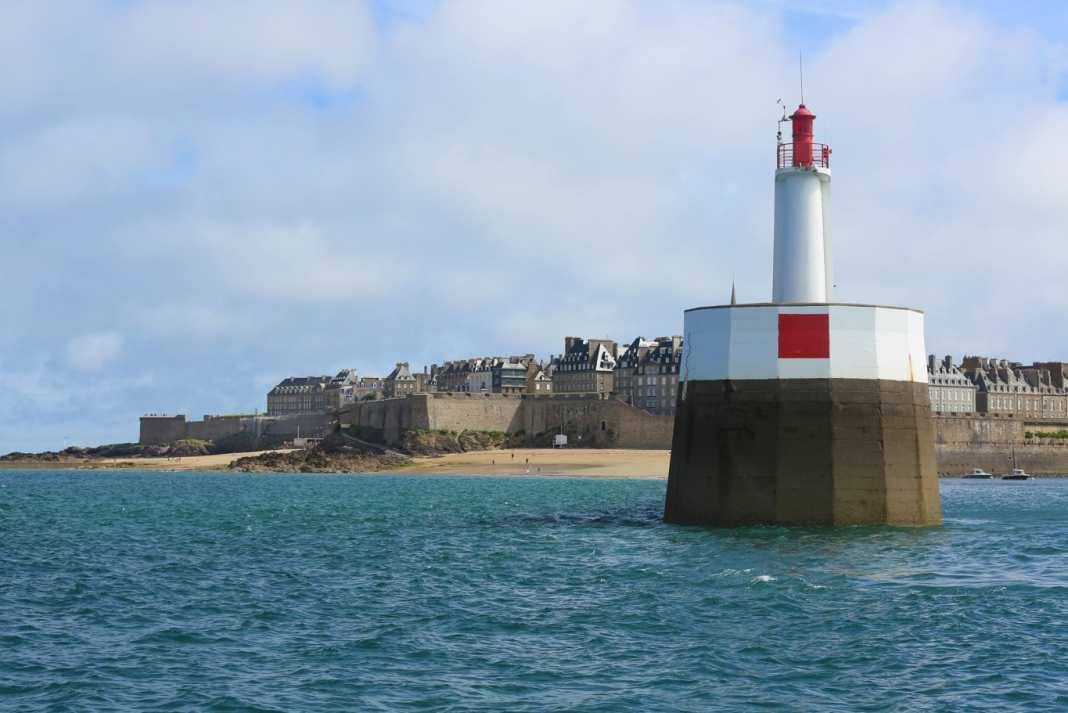
The car ferry to Portsmouth departs in front of us, it's a pretty old boat. This doesn't seem to be the most lucrative route across the English Channel. The water is rising and there are already more than four metres of water above the seuil at the harbour entrance, the coaming, which always guarantees two metres of water on the inside. The sky clears and the sun comes out to see us off.
We pass the sky-high gate of the pier walls, with Saint-Malo to the right against the light. The dead-straight fairway leads north-west across the roadstead of Saint-Malo, with the rocks and islands sinking deeper to the right and left as the tide rises. Yachts cross against the north-west towards the approach.
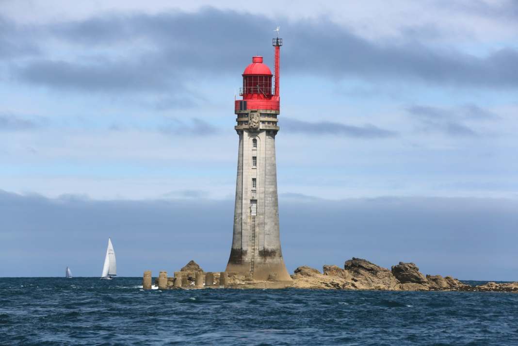
The Le Grand Jardin lighthouse at the start of the approach to Saint-Malo
Only when we have the Le Grand Jardin lighthouse ahead on starboard do we feel a stronger swell. We turn right onto an ENE course that will take us across the bay of Mont-Saint-Michel. Past the Île de Cézembre and then onwards, with two waypoints towards our first destination for the day, the harbour of Granville. It's getting hazy; the famous rock with its cathedral, which gave the wide, shallow bay its name, can just be glimpsed on the horizon in the south-east.
Granville: On-board visit from the border guard
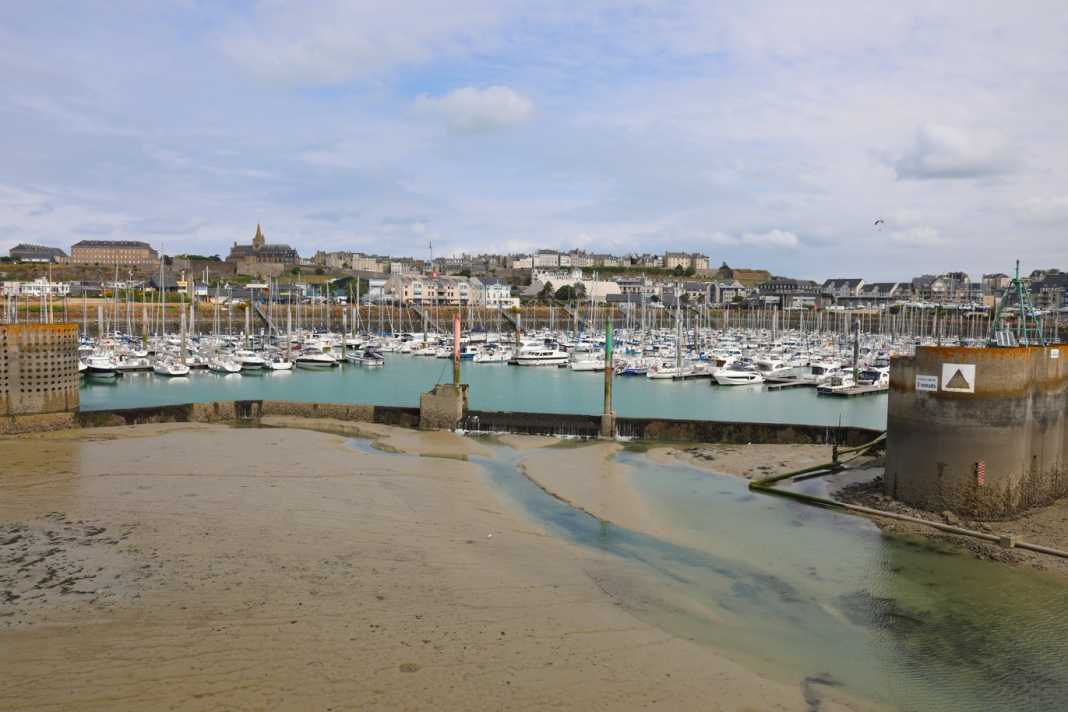
We are now travelling almost alone until we reach the coast of the Cotentin peninsula, which is already part of Normandy. Granville is heralded by the Pointe du Roc, a cape with cliffs and a lighthouse. The harbours, again surrounded by fortress-like protective walls and overlooked by two churches, lie to the east. The fishing harbour is protected by a lock gate and at Port de Hérel, a seuil prevents the marina from falling dry, which can be accessed from three hours before to three hours after high tide.
There we find a spot right next to the "Visiteurs" sign - but also diagonally opposite a grey douanes patrol boat. Of course, the five border officials start their shift by visiting us on board ... We've never been checked so thoroughly before, although it's clear that we've just come from Saint-Malo and have to appear completely unsuspicious. This goes on for a good half hour until we are finally wished a safe journey and, as we want to continue on to the Channel Islands, have fun with "les Anglais".
Christian Dior's church and colourfully painted bunkers
Granville, initially grey and somewhat unapproachable, becomes more accessible in the sunlight of the second day. With just over an hour left, we set off for the haute ville, the historic upper town, buy souvenirs at Place Cambernon and resist the temptations of La Rafale, where we had stopped last night. Mali Blues drifts outside and the landlord with the curved gag beard wipes his tables on the street.
We follow Rue Notre Dame towards Le Roc, the headland. Flowers bloom on the stone façades and what is made of wood has been brightly painted. We reach the large church, which was begun under English rule in the 15th century but not completed until the 18th century. As the French Wikipedia entry reveals, it is in the Flamboyant Gothic style: a term I have never heard before, but it is fitting that none other than Christian Dior was baptised here in 1908. Another extravagant detail: although the entire mainland coast is made of nothing but stone, the granite for the construction of the church was brought from the Îles Chausey, our destination today, in small cargo ships, the so-called gabares. Apparently, no effort was too great for the glory of the Lord ...
The marina of Granville in the Port de Hérel
On to the cape, where the wind blows through the bushes and the few trees - and around the numerous bunkers. Standard blocks from the concrete construction kit, Hitler's Atlantic Wall. One of these so-called standard buildings is painted as a house, with a brick pattern and windows. Naive painting in the truest sense of the word, but historically documented as a crude camouflage measure. With the Granville lighthouse behind it, the former coastal artillery position forms an unusual ensemble. Otherwise, it is a beautiful place, with a sweeping view to the north over the curved coastline of the Cotentin. An unobtrusive monument, a steel plate with a cut-out Lorraine cross, commemorates the Resistance and the fighting after the Allied landings. The horizon can be seen through the long cross arm of the cross.
Control of the Sound de Chausey
Farewell to the French mainland
When we finally set sail, with 3.30 metres of water above the seuil, the sky had long since closed up again. It is barely nine nautical miles to the southern approach to Îles Chausey. It doesn't matter that the westerly wind on this leg is once again blowing directly from the front at three Beaufort. Finally, the first sharply contoured rocks emerge from the sea on the starboard side.
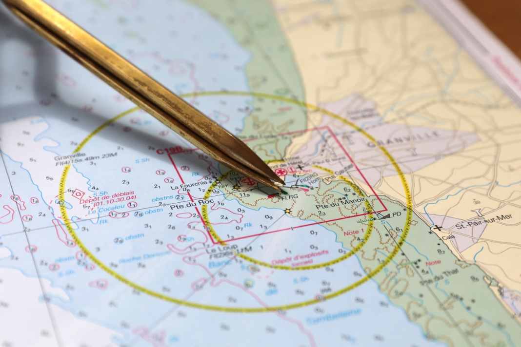
Our destination is the Grande Île. It is the only French Channel Island and, despite its grandiose name, also the smallest at barely two kilometres in length. But if you look at the nautical chart of the Îles Chausey, a whole double page at a scale of 1 : 25,000, you see a completely different picture: The archipelago measures nine nautical miles from west to east, three from north to south. It is crossed by a fairway, the Chenal Beauchamp. The rest is coloured green and is therefore dry. Now, shortly before high tide, there is hardly any sign of it, but that is about to change.
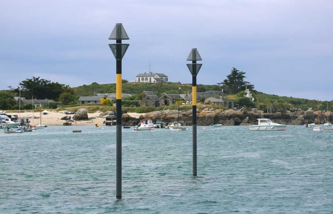
Another navigable entrance, the Sound de Chausey, follows the eastern shore of the main island, which not only has a lighthouse at its highest point, but also a number of other buildings. Passing the flooded landing stage for the day ferry, the high cardinal poles, the "Eiffel Tower", a lattice mast with a sea mark, we make our way to the buoy field. Of course, we leave the douanes' mooring ring free. The current is already running out and it takes a while before we are finally moored in front of the bow and stern on two lines.
A former thonier, a tuna fisherman, on the bay of Mont-Saint-Michel
Insider tip in the Gulf of Saint-Malo: the Îles Chausey
We are just sitting at the jetty when the harbour captain comes by with his RIB and makes himself comfortable on board with us; the night costs twelve euros, you can't complain about that. The rocks slowly rise out of the water around us, black and brown, and join together to form ridges. You don't want to walk on any of them. In Scandinavia, the granite has been polished smooth by the glaciers, here everything is sharp-edged, despite the wind and waves that have been passing over it for thousands of years.
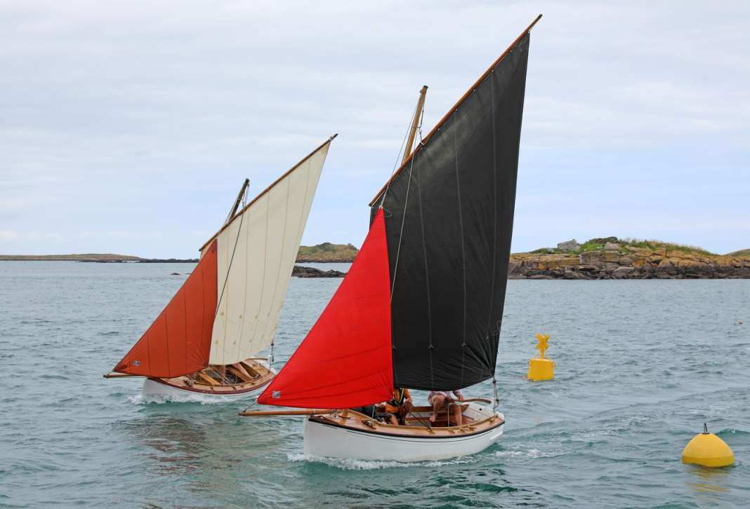
Classic fishing boats as daysailers on the Sound de Chausey
Into the dinghy. We pull our dinghy ashore by the wide brick slipway, on the outside of which the last passenger ferry of the day is just coming alongside. We don't need to tie it up, it will be higher later. However, we have no idea how high ...
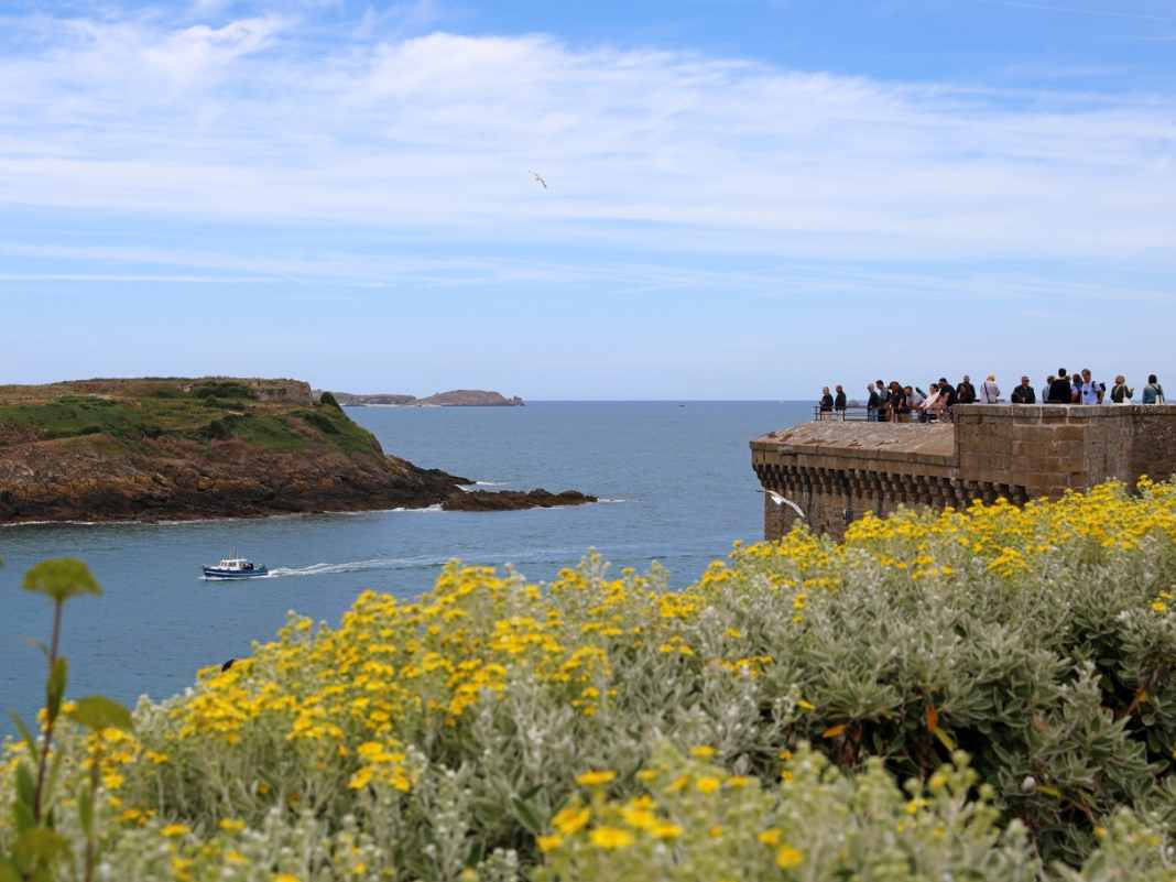
Memorial stone for Éric Tabarly on Grande Île
Shore leave! Day trippers come towards us and board the "Joly France". Lobster baskets flank the path, and at the top of the crossing a memorial stone commemorates the sailing legend Éric Tabarly, who died at sea. Of the two restaurants, we like the simpler one, Contre Vents et Marées, much better. There's a lot going on inside and the large panoramic windows look out onto the sound. We book a table and explore until then.
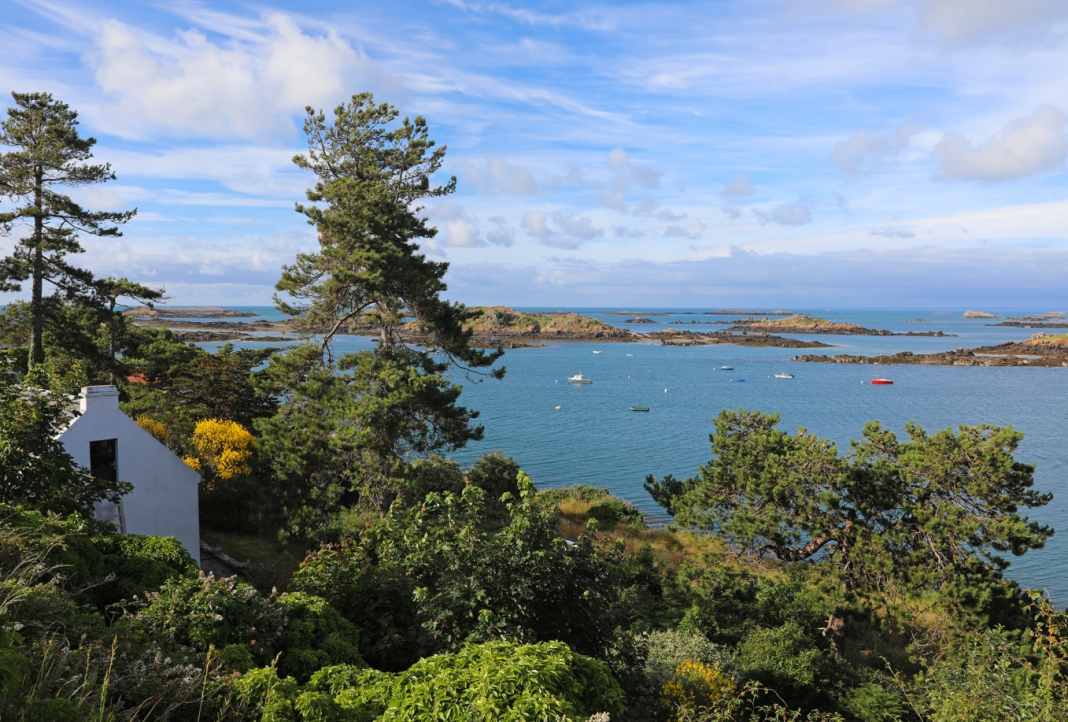
Beautiful panorama with the Sound de Chausey
Narrow paths wind their way between hedges, here and there a whitewashed chalet is hidden between crooked pine trees. On to the overgrown fort, then to the lighthouse and the church. There are even four beaches. The Grande Île is truly beautiful, a sparkling gem. In addition, the restaurant offers a magnificent view of a fantastic landscape where the sea used to be. There, a plateau enclosed by high cliffs! Not that far away. I wonder if anyone has ever set foot on it?
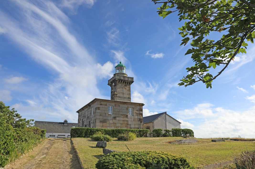
Chausey lighthouse on Grande Île
The mood is good and remains so until we realise in the twilight after dinner that the ramp with our not quite light RIB no longer leads directly to the water - but into the stony, sandy silt at the bottom of the small bay. We have to tow almost 50 metres. Isn't someone laughing somewhere in the darkness? We finally get back on board with cold feet. But you never stop learning. Tomorrow we will continue on to Jersey - to the "Anglais".
 Figure 1: Most historic maps were created as artworks for the public.
 Figure 3: Created in 1727, this beautiful map of Japan shows the distorted visualization of what we now know to be the true shape of the current island.
 Figure 4: Antarctica long remained one of the last mysteries on the world map, both due to its inaccessibility and its low profitability for explorers.