An innovative exchange of sovereign debt for marine conservation, backed by the likes of Leonardo DiCaprio, could pave the way to saving large swaths of the world’s oceans
The tropical island nation of Seychelles is to create two huge new marine parks in return for a large amount of its national debt being written off, in the first scheme of its kind in the world.
The novel financial engineering, effectively swapping debt for dolphins and other marine life, aims to throw a lifeline to corals, tuna and turtles being caught in a storm of overfishing and climate change.
If it works, it will also secure the economic future of the nation, which depends entirely on tourism and fishing.
With other ocean states lining up to follow, the approach could transform large swaths of the planet’s troubled seas.
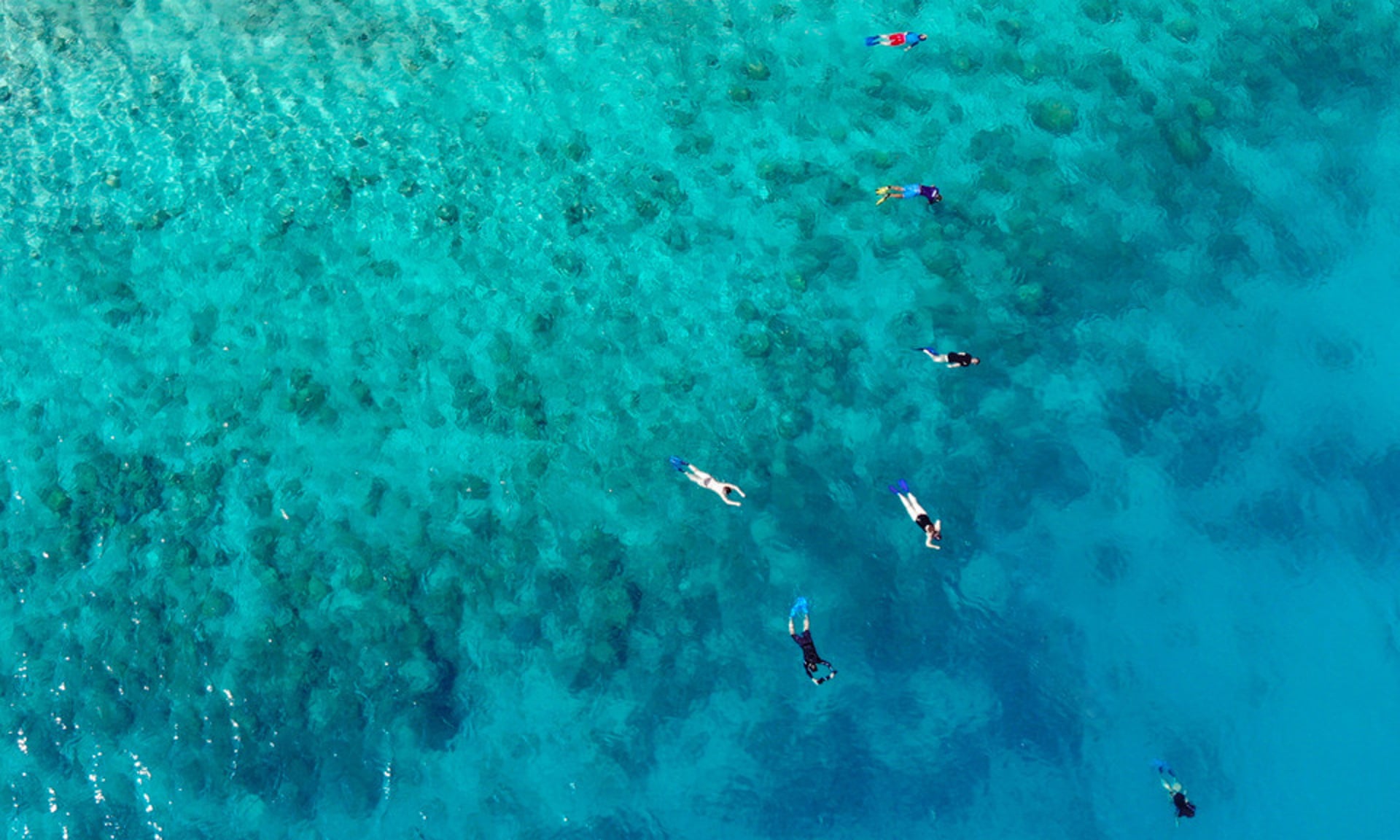
The new parks will cover 15% of the Seychelles ocean.
Photograph: The Ocean Agency
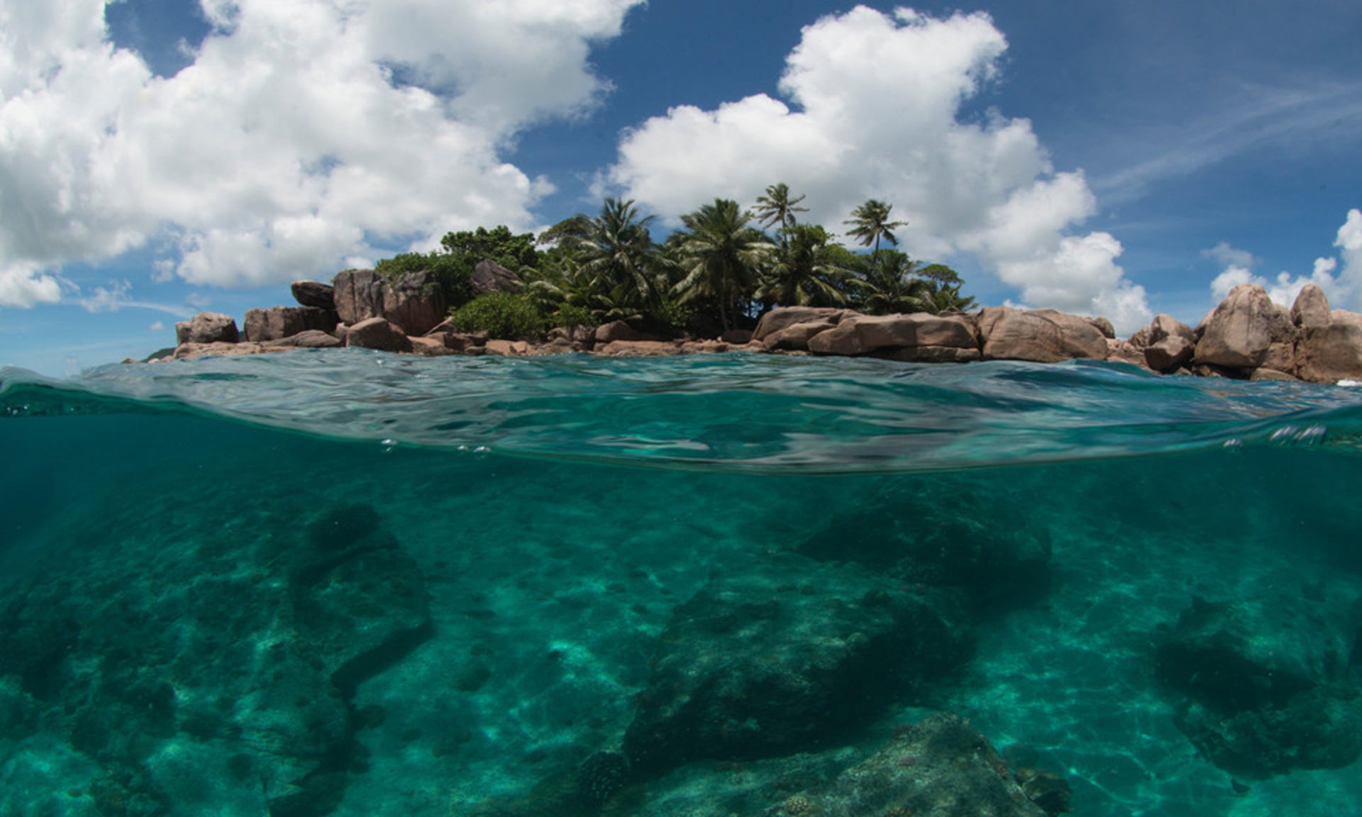
The challenge for the Seychelles is clear on the coral reef fringing Curieuse Island, once a leper colony and now a national park.
The mass bleaching caused by warming waters in 2016 has left the white limbs of branching corals lying like bones in a ploughed graveyard, with rare flashes of the cobalt-blue coral survivors.
“The biggest changes are climate change,” says David Rowat, a marine scientist and diving school owner for 30 years, who says storms and bleaching events are becoming more frequent.
Some clownfish have never returned since the major bleaching in 1998, he says: “The ‘nemos’ all went.” As the reef recovered, the 2016 bleaching was a “kick in the teeth”, Rowat says.
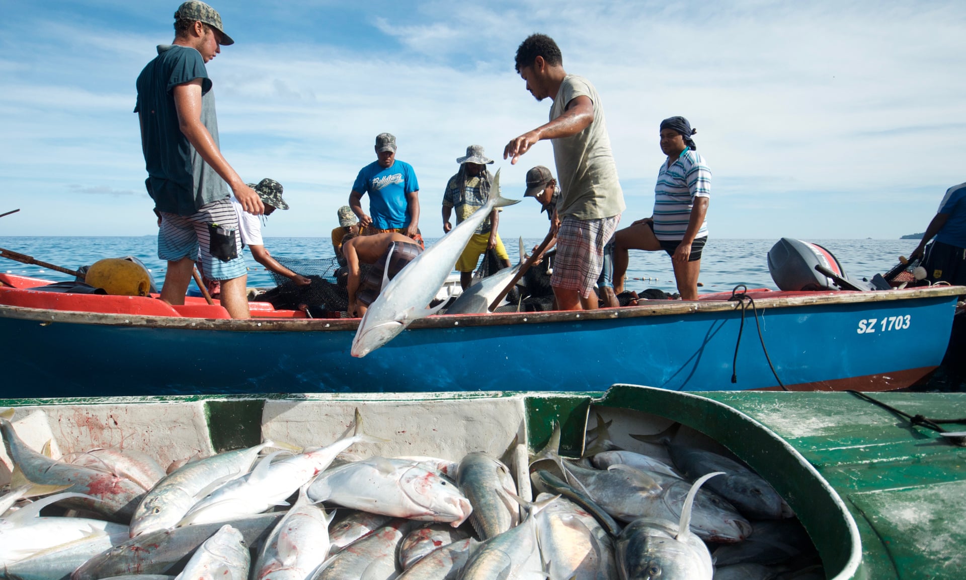
Overfishing, and the killing of dolphins, sharks and turtles as bycatch in tuna nets, is also taking its toll across the Seychelles’ vast ocean territory.
The new marine plan bans fishing around biodiversity hotspots, keeping them healthy and better able to resist climate change.
Storms and coral bleaching are becoming more frequent in the Seychelles.
Photograph: The Ocean Agency
The biodiversity jewel in the Seychelles crown is the Aldabra archipelago, which rivals the Galapagos in ecological importance.
Spinner dolphins, manta rays, humpback whales and nurse, lemon and tiger sharks share the waters with hawksbill and green turtles, and seabirds from some of the world’s largest colonies soar above.
Dugongs - or sea cows - are the most endangered species in the Indian Ocean and shelter here, while 100,000 rare giant tortoises slowly roam the land.
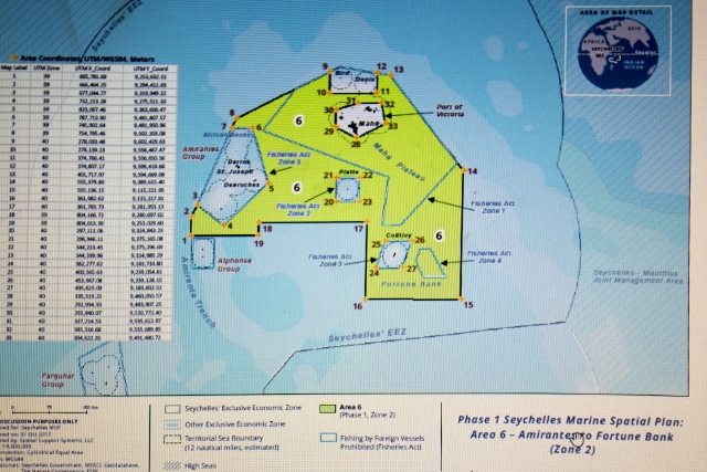
The new protected area around Aldabra is 74,000 square kilometres - almost the size of Scotland - and bans all extractive uses, from fishing to oil exploitation.
The second new protected area is 134,000 sq km, centred on the main Seychelles island of Mahe.
It allows controlled activities but is, for example, banning “fish aggregating devices” – rafts that concentrate fish but drive up bycatch.
Together, the parks cover 15% of the Seychelles ocean and the government will double this by 2021, putting it far ahead of an international target of 10% by 2020.
The parks resulted from the first ever debt-swap deal for marine protection in which $22m of national debt owed to the UK, France, Belgium and Italy was bought at a discount by The Nature Conservancy (TNC), the NGO that has assisted the Seychelles.
TNC also raised $5m from donors to pay off part of the debt and cut the interest rate charged to the Seychelles government on the outstanding loan.
This has freed up $12m over the next 20 years to help implement the new marine plan.
“The Seychelles is positioning itself as a world leader in ocean governance,” says environment minister, Didier Dogley.
“But we are not doing this because we have such a great ego but because we truly believe these initiatives will create prosperity for our people, conserve critical biodiversity and build resilience against climate change.”
In the Seychelles, the investigation enters the shady world of longline fishing.
Leonardo DiCaprio, whose foundation donated $1m towards funding the debt swap, said: “These protections mean that all species living in these waters or migrating through them are now far better shielded from overfishing, pollution, and climate change.”
Benoît Bosquet, environment practice manager at the World Bank, which is not involved in the Seychelles marine plan, said: “They are a leader in this field worldwide and may be an example for many other countries.”
However, despite the biggest consultation since the Seychelles nation was founded, some islanders have not welcomed the new plan.
On Praslin island, as he unloads his catch of job fish and white spotted snappers onto Grande Anse beach, fisherman Richard Bossy, says: “We are worried. They want to make a lot of regulated areas where we can’t fish. Fishing is already harder and we are going to lose a lot. If there is not enough enforcement, it will never be implemented.”
Leroy Lesperance, who charters glass-bottomed and game-fishing boats to tourists on Praslin, is also sceptical the plan will become a reality: “I am 44 and I have heard this talk since I was at school.”
Some fishermen are worried about the conservation plan.
Photograph: Tate Drucker / The Nature Conservancy
But others have bought into the idea, including Graham Green, a young fisherman at Baie St Anne on Praslin: “If the fish are protected where they are spawning, I’ve heard they will get bigger.
We need to do it if we are going to be catching fish in 20 years.”
Green expects the benefits will take perhaps five-10 years to be realised, but sees it as an investment: “You couldn’t start a business today and be a millionaire tomorrow - if you could everyone would be a millionaire.”
Another challenge to the marine plan is a controversial new military base planned for the island of Assumption, about 20 miles from the Aldabra atoll and to be paid for by India.
One well-informed source, who asked for anonymity, told the Guardian: “I am worried that it could damage the biodiversity of Aldabra.
We are talking about big ships coming in to berth.” That implies pollution and the dredging of channels, which can cover corals in silt, he says.
“The Assumption saga will certainly test the credibility of the marine spatial plan process,” says Keith Andre, from the Fisherman and Boat Owners Association.
But Seychelles vice-president, Vincent Meriton, says the military base will have to pass environmental assessments and will actually benefit protection, by enabling better surveillance around the isolated Aldabra archipelago: “This facility will allow us to better monitor.
It augurs well.”
Oil exploration is another dilemma for the Seychelles, which could be sitting on “world-class” reserves, according to Patrick Joseph, CEO of PetroSeychelles, a state-owned company.
It has given up some high-priority prospects, such as the Wilkes seamount which is now in the Aldabra protection zone.
But, pointing to the revisions to the plan expected every five years, he says: “If the price of oil goes a bit higher, there will be companies drilling here in the Seychelles.”
Andre, pointing to the possibility of seismic surveys in the protected zone around Aldabra, says: “The nature and impacts of these activities contradicts the authenticity of the entire process.”
New satellite surveillance programmes could detect the patterns of fishing boats.
Photograph: The Ocean Agency
Many of the details of exactly what is allowed in the protected zones could not be finalized until the areas were selected and are still being worked out, meaning many difficult negotiations still lie ahead.
“It is a chicken and egg situation,” says Helena Sims, TNC’s project manager in the Seychelles.
“But we have built trust from the bottom up and if we keep that and are transparent I am positive our targets can be met.”
The Seychelles debt swap is a vital test case for this new way of funding ocean conservation.
Rob Weary at TNC did the deal and expects to close a $60m debt swap deal with Grenada this year and a series of others in the Caribbean in the next couple of years.
Mauritius also has serious interest.
Despite the election of Donald Trump scuppering for now planned swaps of US debt for Palau and the Marshall Islands in the Pacific, Weary is confident debt swaps for marine conservation are going to grow: “In the next three to five years we could potentially do a billion dollars of these deals.
We have a sight line to that.”
“All eyes are on us to see whether it works,” says Sims.
The Seychelles, which is 99% ocean, will have gone from 0.04% to 30% protected area in a few years if it does.
Questions, such as oil exploration, remain.
But environment minister Dogley says: “We don’t have answers for everything now but the marine spatial plan has started the process of thinking about these things - before we were not.
The debt swap triggered everything.”
Residents look at an exposed erosion along the boardwalk of Macumba beach after waves washed away the sand in the weekend storm, in Rio de Janeiro on Oct 17
The world is far off course from its goals in cutting greenhouse gas emissions — and research published Tuesday illustrates one of the most striking implications of this.
Namely, it finds that for every five years in the present that we continue to put off strong action on climate change, the ocean could rise an additional eight inches by the year 2300 — a dramatic illustration of just how much decisions in the present will affect distant future generations.
“One important point was to reveal that sea level [rise] is not in the far future, it’s now, and because the system is so slow, we just can’t see it at the moment,” said Matthias Mengel of Germany’s Potsdam Institute for Climate Impact Research, the lead author of the study, which was published in Nature Communications.
“But we cause it now.”
The study, which also included scientists at institutions in Australia and Austria, takes as its premise that the world will work to achieve the Paris climate agreement’s sharp cuts in greenhouse gas emissions.
The goal is to limit warming below 2 degrees Celsius (3.6 degrees Fahrenheit), which requires that the world essentially cease adding any more greenhouse gases to the atmosphere by 2050 or so.
This, in turn, means that global greenhouse gas emissions must reach a peak by either 2020, 2025 or 2030 (or possibly 2035) and then begin to decline rapidly.
The longer the wait, the faster the necessary decline after the peak.
If we delay longer still, it simply becomes too difficult to bring emissions down fast enough to avoid dangerous levels of global warming.
All of this has major implications for the global sea-level-rise commitment, the study finds.
Because emissions today impel rising seas over centuries, the researchers were able to calculate a surprisingly large impact of present choices on sea levels in the distant future.
For every five-year delay in the peaking of emissions, the middle-range sea level projection for 2300 increased by 20 centimeters, or about eight inches, the study found.
“The more cumulative emissions, the more warming, the more sea level,” Mengel explained.
Giant tabular icebergs surrounded by ice floe drift in Vincennes Bay in the Australian Antarctic Territory
photo Reuters
And that’s just the central estimate in the study.
At the extreme end of what’s relatively unlikely but still certainly possible, the research found that each five-year delay could mean as much as an additional meter, or over three feet, of sea level rise.
That is because of the ever-growing chance of major destabilization of the Antarctic ice sheet.
In some small number of scenarios, even with the sharp emissions reductions contemplated by the Paris agreement, the Antarctic ice sheet still gives up meters worth of sea level rise.
“It tells us that we are really uncertain, we don’t know enough about the ice sheets,” Mengel said.
Eight inches of sea level rise is about what the planet experienced during the entirety of the 20th century, Mengel said.
That itself highlights how much worse sea level rise could get in the future, as global warming increasingly warms the oceans (causing them to expand) and melts glaciers, the Greenland ice sheet and Antarctica.
It is important to note that Mengel’s study considers only sea level rise scenarios that are consistent with the very ambitious goals of the Paris agreement.
The world is not at all on a pathway to achieve those goals.
And even in these rosy scenarios, the study finds that seas could rise by between 2.3 and 4 feet by 2300, or about .75 to 1.33 feet per century.
If we miss the Paris targets, sea level rise could be far worse.
Last week, for instance, a different team of scientists confirmed that the pace of sea level rise is accelerating.
Extrapolating forward, their study in the Proceedings of the National Academy of Sciences found that if the current rate of increase continues, seas would rises by 2.13 feet by 2100 alone.
New Study Brings Antarctic Ice Loss Into Sharper Focus
Meanwhile, a state-of-the-art study released last week in the open-access Cryosphere journal suggested that the loss of ice in Antarctica is also speeding up, which probably accounts for part of that acceleration.
In that work, a team of scientists with NASA and several institutions in the United States, Norway and the Netherlands found that the southern continent is losing about 183 billion tons of ice per year — thanks in part to an annual increase of 36 billion tons in the amount of total ice released from the continent into the ocean between 2008 and 2015.
The change is modest, given the total size of Antarctica — where about 2,000 billion tons of ice are added each year through snowfall, and even more are lost as ice breaks away, melts or gets blown back into the sea.
But, worryingly, most of the loss and the loss acceleration is concentrated in West Antarctica, long believed to be the weak underbelly of the Antarctic ice sheet.
“When we compare our current mapping of Antarctica to the one that was done in 2008, we’re seeing an acceleration in West Antarctica, very little change in East Antarctica, and very little change in the peninsula overall,” said Ted Scambos, an Antarctic expert at the National Snow and Ice Data Center and one of the Cryosphere study’s authors.
The West Antarctic ice loss is 214 billion tons per year on average, Scambos said.
An additional 31 billion tons are lost from the Antarctic peninsula, and 61 billion are gained in East Antarctica because of snowfall, according to the scientists’ estimates.
It all points to the same conclusion — just where the ocean laps at shorelines experienced by a child in the year 2300 will very much depend on the present, and which pathway we choose to take, at a time when critical decisions about climate change are being made.
“The Paris agreement, it’s strict on what can happen,” Mengel said.
“It bounds our future.
… It shifts the focus to the next decades.”
The Chairman of The Nippon Foundation, Yohei Sasakawa, has announced that The Nippon Foundation – GEBCO Seabed 2030 project to map the bathymetry of the world’s entire ocean floor by 2030 has started.
The Nippon Foundation has pledged $2 million per year as seed money – and is calling on the resources of the international maritime community for additional support.
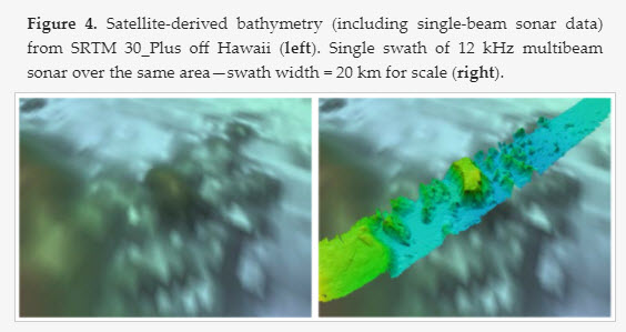
A concept paper for the project highlights that the vast majority of the world ocean has not been sampled by echo sounders even at a resolution of about 30 arc seconds.
Considering that many of the approximately one kilometer grid cells only have a single sounding in them, the percentage of the seafloor that has actually been measured by echo-sounders is considerably less than 18 percent.
Satellite altimetry-derived bathymetry has represented an advancement, providing global coverage of general estimates of depths.
However, it is far less precise than echo sounder-derived data and has far less resolution than modern multi-beam sonars.
Understanding the bathymetry (seabed depth) of the global ocean is imperative, not only for improving maritime navigation, but also for enhancing our ability to predict climate change and monitor marine biodiversity and resources, says Sasakawa.
The project will make a significant contribution to the U.N.’s Sustainable Development Goal 14: to conserve and sustainably use the oceans, seas and marine resources for sustainable development.
A comprehensive map of the seafloor will assist global efforts to combat pollution, aid marine conservation, forecast tsunami wave propagation, and help inform the study of tides, wave action, and sediment transport.
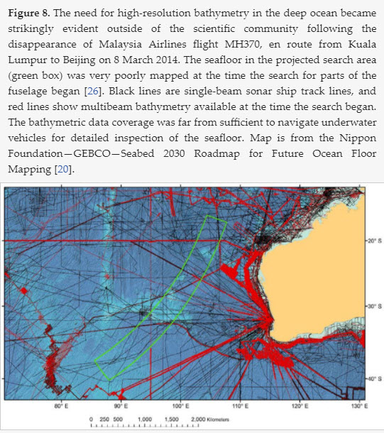
The need for bathymetric data was also highlighted by the disappearance in March 2014 of Malaysian Airlines flight, MH370.
Since its launch, the project has made rapid progress, drawing on the experience of some 28 international organizations around the world.
The project’s structure is based on a roadmap produced by an establishment team of leading ocean mapping experts.
Sea floor mapping in search for missing flight MH370 released
“The Nippon Foundation alone cannot achieve the objectives of this ambitious project,” said Sasakawa.
“We will need the support of a large number of stakeholders, including world-leading technical experts.
It is crucially important that the maritime community comes together to achieve this important goal.”
As shallow seas lie mostly in the territorial waters of coastal states and much of the responsibility for mapping these waters will rest with local hydrographic agencies, most of the effort of the Nippon Foundation GEBCO Seabed 2030 Project will be focused on the 93 percent of the world’s oceans that is deeper than 200 meters and often beyond the jurisdiction of local hydrographic agencies.
For the other seven percent, the project will work closely with local hydrographic agencies to obtain shallow water data wherever possible.
Four Regional Centers have been set up, each with responsibility for a region of the world’s ocean, with a Global Center to produce the global map.
The Regional Centers are based at The Alfred Wegener Institute (AWI), Germany, covering the Southern Ocean; The National Institute of Water and Atmospheric Research (NIWA), Wellington, New Zealand, covering the South and West Pacific Ocean; The Lamont Doherty Earth Observatory, Columbia University, U.S., covering the Atlantic and Indian Oceans; and Stockholm University, Sweden, in partnership with the University of New Hampshire, U.S., for the North Pacific and Arctic Ocean.
The Global Center, which is responsible for centralized data management and products, is based at the U.K. National Oceanography Center, Southampton.
The Regional Centers will identify existing data from their assigned regions that are not currently in publicly available databases and seek to make these data available.
They will develop protocols for data collection and common software and other tools to assemble and attribute appropriate metadata as they assimilate regional grids using standardized techniques.
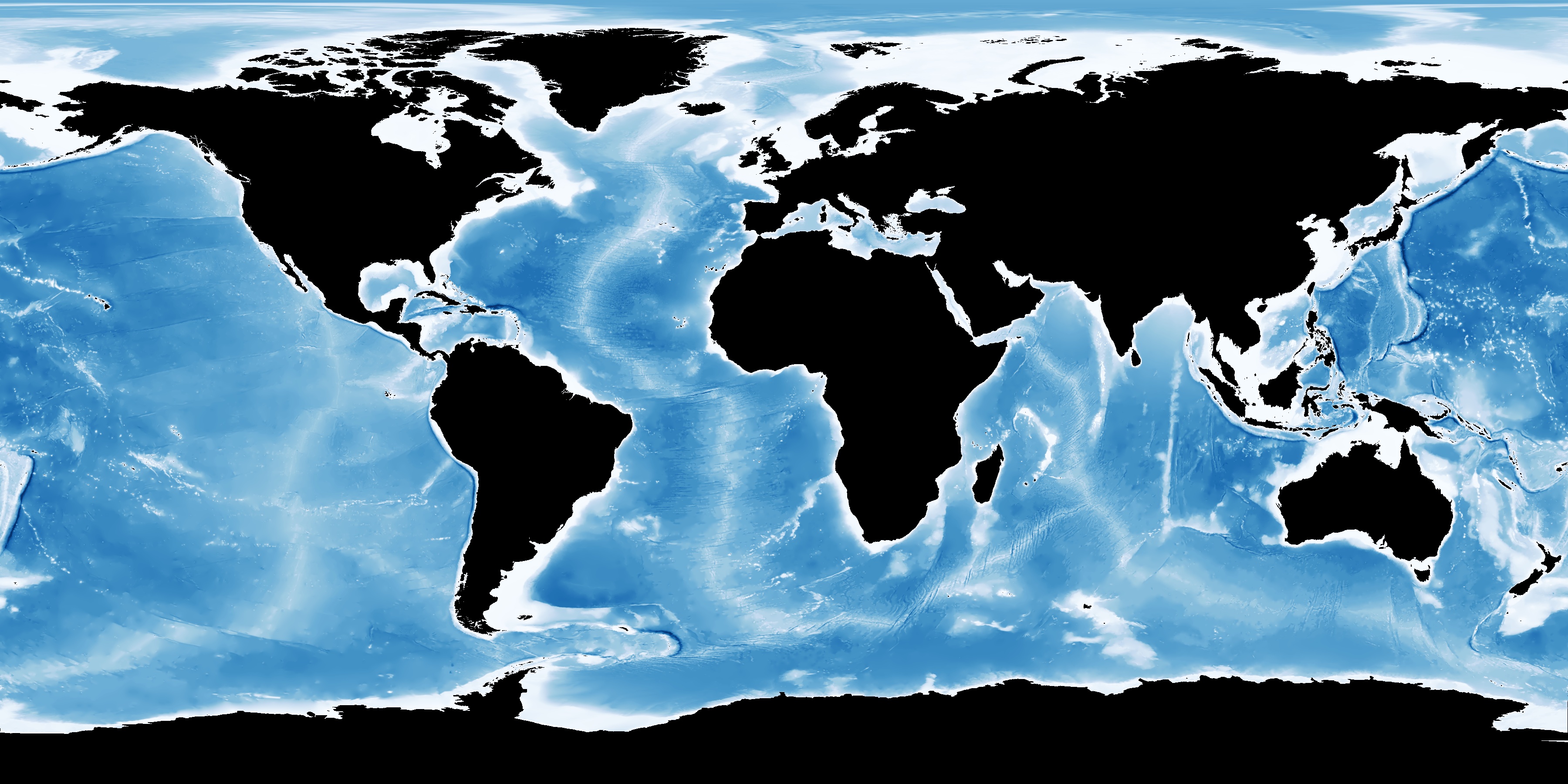
GEBCO bathymetry
(cortesy of OMG)
The Global Center will integrate the regional grids into a global grid and distribute to users world-wide.
It will also act as the central focal point for the coordination of common data standards and processing tools.
The project will encourage and help coordinate and track new survey efforts and facilitate the development of new technologies that can increase the efficiency of seafloor mapping.
GEBCO-NF Alumni team completes XPRIZE testing phase
Satinder Bindra has been appointed leader of the international project team and brings a wealth of experience to the project, having previously worked for the Asian Development Bank, the United Nations Development Programme and UN Environment, where he promoted key environmental initiatives and sustainable development.
Bindra said: “This is a challenging opportunity to build a global common good and do something meaningful for our future generations.
The scale and scope of the project is such that we will have to work with international organizations, universities, civil society, the private sector, maritime industries -including fishing and shipping, youth organizations and citizens from every corner of the world.
As we strengthen our cooperation, we will deepen our understanding of the oceans and enhance our ability to map the remaining 85 percent of the ocean floor much faster than ever before.’’
Soon after delivery, Eduard Toll (Icebreaker LNG Carrier) made its way to complete both its first loading at Sabetta Terminal Russia and first discharge in Montoir, France.
This marked a major milestone for shipping in the arctic as this was the first time a shipping vessel made independent passage, without the support of an ice breaker, during this time of year.
The team onboard captured a timelapse of their voyage showing the start of the Northern Sea Route transit.
Crossing of polar region is becoming easier due to warming global temperatures and thinning sea ice
The tanker, containing liquefied natural gas, is the first commercial vessel to make such a crossing alone during the winter months. The voyage is a significant moment in the story of climate change in the Arctic and will be seized on by those with concerns about thinning polar ice and its implications for the environment.
The Eduard Toll is named after a Russian geologist and explorer
(Picture: Teekay)
Belonging to the shipping company Teekay, the ship Eduard Toll made its way from South Korea to the Sabetta terminal in northern Russia in December. From there, it sailed to Montoir in France to deliver a load of liquefied natural gas.
A similar vessel made the same crossing in August last year, but this is the first time it has been completed when the temperatures are at their coldest. “The people and passion one needs for an ice passage like this cannot be underestimated,” Teekay gas group’s president and chief executive, Mark Kremin, told TradeWinds.
As global warming leads to melting Arctic ice, areas of the northern oceans are becoming accessible to vessels for the first time.
Shipping companies have been investing in ships that are able to break through thinning polar ice, as the northern sea route is considerably shorter for many trade links between Europe and Asia. Teekay is investing in six ships to travel to its liquefied natural gas project in Yamal, northern Russia.
One study suggested European routes to Asia will become 10 days faster via the Arctic than alternatives by the middle of the century, and 13 days faster by the end. “The reduction in summer sea ice, perhaps the most striking sign of climate change, may also provide economic opportunities,” Dr Nathanael Melia, one of the authors of that study, said at the time. “There is renewed interest in trans-Arctic shipping because of potentially reduced costs and journey times between Asia and the Atlantic.”
However, environmentalists and scientists have expressed concerns over the opening of the northern route and exploitation of polar resources. In December, the EU and nine of the world’s major fishing nations announced an agreement to ban fishing in the Arctic Ocean for the next 16 years.
This was welcomed by environmentalists and scientists who pointed out the fragility of polar ecosystems, and the need to preserve them instead of merely exploiting resources made newly available my melting sea ice.
But even non-fishing vessels can cause damage to the Arctic due to the pollution they emit into a largely pristine environment. As for the opening of trade routes, environmentalists have noted the irony in the rapidly warming Arctic seas being used as a highway for fossil fuel transport. “The Arctic has already exceeded the Paris agreement’s aspiration of limiting warming to 1.5C, and the agreed target of 2C. In some areas it has warmed by 4C,” said Sarah North, senior oil strategist for Greenpeace International. “Inevitably, this has caused massive changes, with most of the Arctic ice having already disappeared. And so now, ironically, we can deliver fossil fuels more quickly. It’s like a heavy smoker using his tracheotomy to smoke two cigarettes at once.”
Human activity has already affected all parts of the ocean, with pollution increasing and fish-stocks plummeting.
The UN’s recent announcement of a Decade of Ocean Science provides a glimmer of hope, but scientists will need to work closely with decision-makers and society at large to get the ocean back on track.
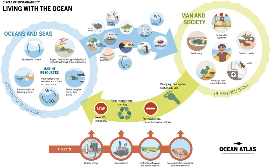
The ocean covers 71% of the Earth’s surface.
It regulates our climate and holds vast and in some cases untouched resources.
It provides us with basics such as food, materials, energy, and transportation, and we also enjoy the seascape for religious or recreational practices.
Today, more than 40% of the global population lives in areas within 200 km of the ocean and 12 out of 15 mega cities are coastal.
Doubling of the world population over the last 50 years, rapid industrial development, and growing human affluence are exerting increasing pressure on the ocean.
Climate change, non-sustainable resource extraction, land-based pollution, and habitat degradation are threatening the productivity and health of the ocean.
In the Deep is a new Quartz series on the wonders of our oceans
and the intrepid scientists seeking to understand them.
It is in this context that over the last few years, scientists and societal actors have organized a bottom-up movement, which has ultimately led to the United Nations General Assembly proclaiming a Decade of Ocean Science for Sustainable Development (2021–2030).
In the process, governments, industry, and scientists have raised awareness of the rapid degradation and over-use of the ocean.
The final document from the Rio+20 summit, The future we want, made extensive reference to the ocean, and the Global Ocean Commission articulated the need for more effective global ocean policies.
Moreover, the 2030 Agenda for Sustainable Development includes an explicit ocean goal (SDG14) that led to the first-ever UN Ocean conference to support its implementation.
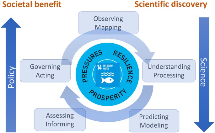
The ambition of the Decade of Ocean Science is to now use this gathering momentum to mobilize the scientific community, policy-makers, business, and civil society around a program of joint research and technological innovation.
Increased need for ocean information to meet societal needs.
Meeting a growing range of societal demands and achieving Sustainable Development Goal 14 (Conserve and sustainably use the oceans, seas, and marine resources) from the 2030 Agenda for Sustainable Development can only be fully realized if all elements of the ocean value chain are resourced adequately and more integrated science agendas are advanced.
First, there is a tremendous opportunity to connect ocean sciences more directly with societal actors by promoting integrated ocean observation and solution-oriented research agendas.
Also, rich and poor nations are increasingly engaging in capacity development and resource sharing.
And finally, the UN system and coastal states have a unique chance to seriously collaborate in multi-stakeholder processes to advance maritime spatial planning and effective ocean governance.
A more integrated and sustainable ocean observing system
The Decade of Ocean Science will encourage actions towards a more integrated and sustainable ocean observing system to facilitate ocean discovery and environmental monitoring.
The vast volume of the ocean and its complex coastlines are neither fully observed nor adequately understood.
In particular the deep sea is a frontier of ocean sciences, where internationally coordinated research teams regularly discover new ocean phenomena of profound importance or new organisms and substances for potential future use.
Sustained and systematic ocean observations are needed to document ocean change, initialize ocean system models and provide critical information for improved ocean understanding.
Advances in ocean robotics and the combination of remote and in situ ocean observations offer new opportunities; and free and open data sharing and multi-stakeholder contributions by governments (rich and poor), the private sector and citizens are opening exciting new dimensions.
International efforts, such as the Global Ocean Observing System, the Blue Planet initiative of the Group on Earth Observations and their Framework for Ocean Observing provide a solid basis and an opportunity for growth.
The upcoming decadal conference on ocean observations, OceanObs 19 will provide an excellent opportunity to advance our ocean observing ambitions.
Ocean Networks Canada
A solution-oriented integrated ocean science agenda
The Decade of Ocean Science should address both deep disciplinary understanding of ocean processes and solution-oriented research to generate new knowledge.
This will support societal actors in reducing ocean pressures, preserving and restoring ocean ecosystems and so safeguard ocean-related prosperity for generations to come.
A solution-oriented integrated ocean science agenda can provide innovative ideas, improved assessments and fundamental knowledge in the context of sustainable development and improving human–ocean interactions.
Our rapidly growing, affluent, and more technologically advanced societies are increasingly impacting their local and the global environment, leading to pollution by both chemical and physical wastes.
Integrated research is needed to assess the human and environmental risks of ongoing and future types of ocean pollution, to generate new ideas to reduce the ocean pressures by promoting recycling, improved waste management and incentive and governance regimes to encourage more sustainable production and consumption.
The most challenging ocean pollutants include: atmospheric carbon dioxide, which causes climate change, ocean warming, ocean acidification, and sea level rise; agricultural fertilizers, which lead to increased primary production but result in ocean deoxygenation; untreated waste water; invasive species; micro and macro plastics, the exponential increase of which has an environmental impact as yet only partially known.
Ocean hazards such as storm surges, harmful algal blooms, or coastline erosion can be devastating for coastal communities.
Throughout human evolution civilization has developed strategies to increase our resilience to threats from the ocean.
However, the rush for coastal recreation and access to the sea has produced newly built infrastructure that is increasingly vulnerable to ocean extreme events.
Hard solutions, such as building walls and levees, could provide some mitigation.
However, softer approaches, such as beach nourishment, restoration of mangroves and reef systems, would also provide natural protection and increase resilience to sea-level rise and storm surges.
Marine protected areas, natural coastal defences, mining codes, or regulations to limit ocean pollution are all critical elements to safeguard ocean resilience.
Humans have always benefitted from the ocean and its diverse ecosystem services.
We often speak of a healthy and productive ocean referring to the desire to maintain the ocean in a prosperous state.
The ocean provides food for many, often poor, coastal communities; provides jobs, energy, and raw materials; and enables global trade and recreational and cultural services.
The sustainability challenge is achieving long-term ocean prosperity for more affluent societies with a global population approaching 10 billion.
Is there sufficient intergenerational will to sustain the overall long-term wealth and well-being of humans by safeguarding ocean resources and ecosystem productivity?
What are the trade-offs and synergies between different strategies of marine food production and wild harvesting, different forms of energy harvesting and extraction of materials and ocean restoring zones?
New research should develop and flesh out sustainable blue-green growth agendas and link it to efforts in ecosystem protection.
The Decade of Ocean Science should develop a new ocean narrative that can provide context and motivation to reduce ocean pressures, increase ocean resilience, and promote ocean prosperity for generations to come.
At the same time, it can provide visibility to existing and new international ocean science programs, such as the new Future Earth Ocean Knowledge–Action network that aims to connect academic and practical knowledge to address the pressing issues of ocean sustainability using the concept of co-design, co-production, and co-dissemination of ocean sustainability knowledge.
The success of the Decade of Ocean Science will critically depend on global capacity building and resource-sharing between countries at different levels of wealth and development.
The enormous need for more ocean information at the scientific, governmental, private sector, and public levels demands a step-change in ocean education at all levels.
New technology to improve ocean observation, more sustainable ocean resource extraction, and the digital revolution are transforming the ocean sciences and information communities.
How can we harness this opportunity?
Perhaps new curricula at universities can provide the opportunity to engage a wide range of disciplines in the area of ocean sustainability.
Global learning formats such as massive open online courses, open access to ocean information and increased interactions between the academic and societal actor communities are all promising activities.
In addition, partnerships between academic and civil society organizations can produce free ocean literacy material, such as the Ocean-Atlas or the World Ocean Review.
However, more engagement at the primary and secondary school levels is urgently needed to promote ocean literacy.
Training courses and exchange programs between south–south and north–south ocean actors, as well as courses for ocean professionals, hold tremendous potential to raise ocean awareness and promote better solutions.
Finally, the Decade of Ocean Science, in conjunction with the 2030 Agenda for Sustainable Development and other international and regional ocean agendas, has shown the need for societal actors to reflect on effective ocean governance.
From a regulatory perspective, coastal states can benefit from a systematic, multi-stakeholder assessment and spatial planning procedure.
In many parts of the world, each cubic meter of ocean is expected to support several, often conflicting, demands.
Spatial planning procedures that take the demands of neighboring countries and the global ocean system into account can help to find more sustainable and equitable regimes of ocean use and access.
Science can help in this effort by reflecting on a range of human development scenarios and evaluating how best to sustain ocean prosperity while respecting planetary and ocean boundaries.
A good example of this is the ocean scenario team that is scoping out development pathways to reach SDG14 and ocean-related goals by 2050 in the context of The World In 2050 project (TWI2050).
The increased awareness of the importance of the ocean to the future of humanity give grounds for cautious optimism and motivation for ambitious multilateral cooperation.
The scientific community has been given a stage on which to shine during the Decade of Ocean Science for Sustainable Development.
Let us come together, respect our disciplines and agendas but also be ready to embark on an exciting and transformative journey to realize the ocean we need for the future we want.
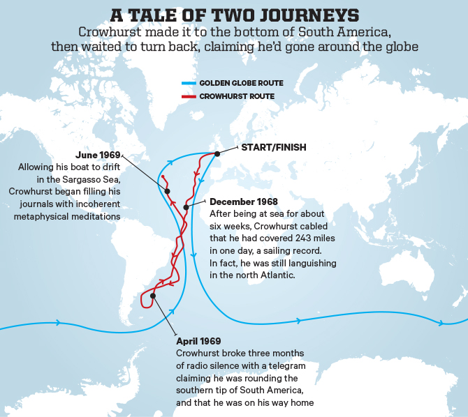
Following his Academy Award® nominated film The Theory of Everything, James Marsh directs the incredible true story of Donald Crowhurst (Colin Firth), an amateur sailor who competed in the 1968 Sunday Times Golden Globe Race in the hope of becoming the first person in history to single-handedly circumnavigate the globe without stopping.
With an unfinished boat and his business and house on the line, Donald leaves his wife, Clare (Rachel Weisz) and their children behind, hesitantly embarking on an adventure on his boat the Teignmouth Electron.
The story of Crowhurst's dangerous solo voyage and the struggles he confronted on the epic journey while his wife Clare and their family awaited his return is one of the most enduring mysteries of recent times.
The somewhat dispiriting real-life story of Donald Crowhurst, the amateur sailor who in 1968-9 lost his pride, his mind and then his life in a single-handed yacht race to circumnavigate the world, has long exerted a fascination for film-makers.
Nicolas Roeg once tried to film the story.
In 2006, the documentary Deep Water explored the tragedy.
And this big-budget take on the tale, buoyed up by the star power of Colin Firth and Rachel Weisz, was made at the same time as a smaller rival project, Crowhurst by Simon Rumley.
Deep Water is a documentary film, directed by Jerry Rothwell and Louise Osmond, produced by Jonny Persey.
It is based on the true story of Donald Crowhurst and the 1969 Sunday Times Golden Globe Race round the world alone in a yacht.
'"We are all human beings and we all have dreams."
Deep Water, beautifully narrated by Tilda Swinton, is a moving and totally absorbing account of one man who gets in over his head both physically and morally.
The small boat becomes a microcosm for life where a person has to find their own rules.
Crowhurst's journey is not the journey of Sunday Times heroes, but of a man.
His dilemma is dangerously easy to identify with.
This is an incredibly moving story - if you don't already know the historical details, do see the film first.
One can see the attraction of the story to director James Marsh: Crowhurst (Firth) has a similar maverick eccentricity and forceful self-belief to that of high-wire walker Philippe Petit, the subject of his documentary Man on Wire.
But for all its technical prowess – the sound design, all groaning metal and hectoring waves, is particularly effective – this account of inexorably crushed dreams is kind of a downer.
Unlike the steely resilience in the face of disaster of Robert Redford’s character in All Is Lost, watching Crowhurst slowly crack is the cinema equivalent of filling your pockets with pebbles and chucking yourself into the Solent.


 Some fishermen are worried about the conservation plan.


