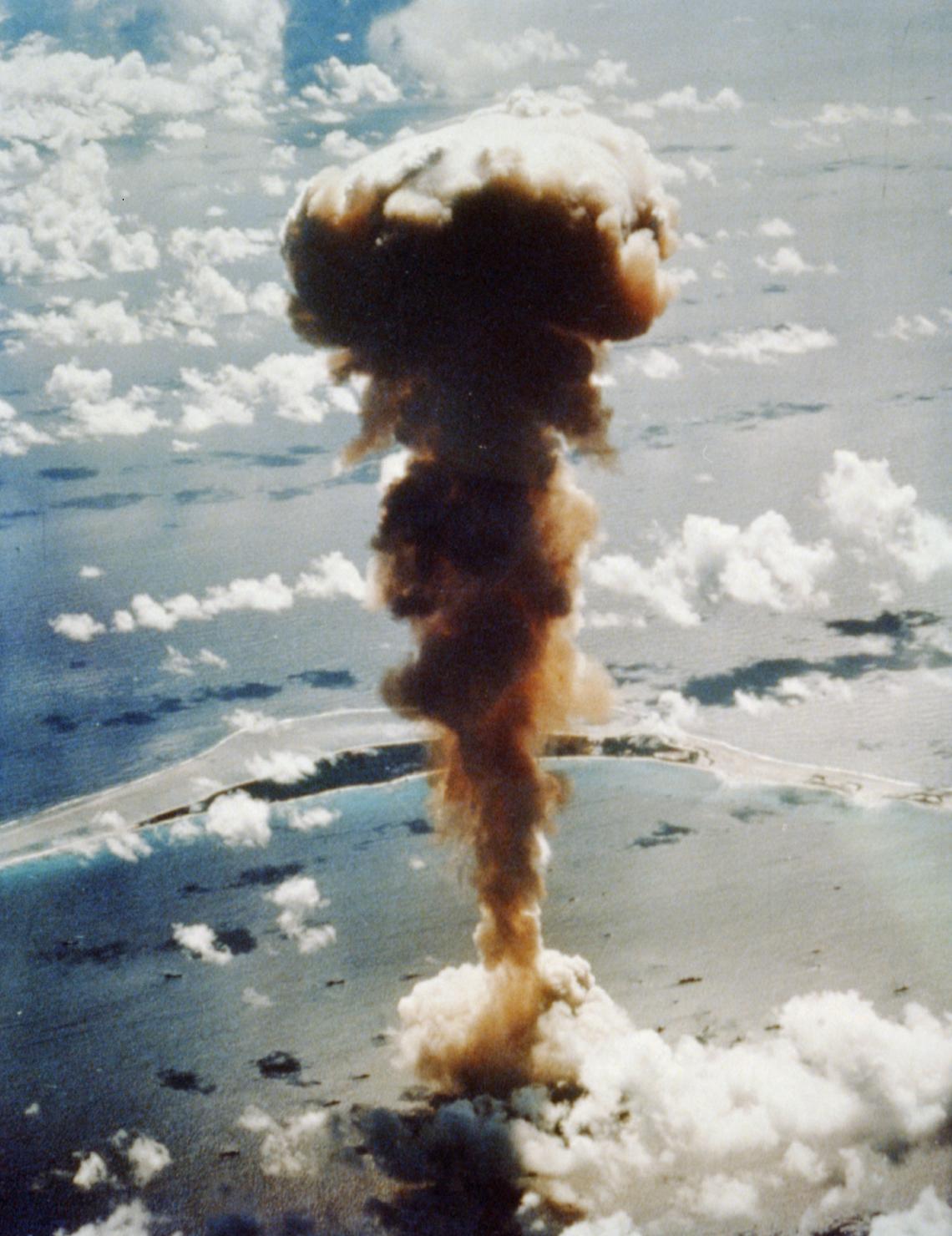
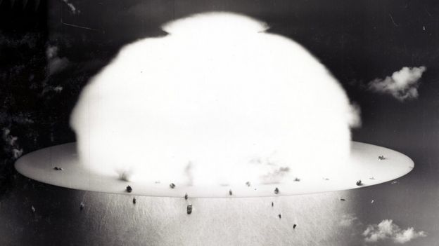
The date was 25 July 1946.
The location - Bikini Atoll.
The event - only the fifth A-bomb explosion and the first-ever detonation under water.
The pictures we've all seen: A giant mushroom cloud climbing out of the Pacific, sweeping up ships that had been deliberately left in harm's way to see what nuclear war was capable of.
Bikini atoll with the GeoGarage platform (NGA nautical raster chart)
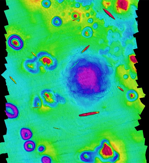
Now, 73 years later, scientists have been back to map the seafloor.
A crater is still present; so too the twisted remains of all those vessels.
"Bikini was chosen because of its idyllic remoteness and its large, easily accessible lagoon," explains survey team-leader Art Trembanis from the University of Delaware.
"At the time, [the famous American comedian] Bob Hope quipped, 'as soon as the war ended, we found the one spot on Earth that had been untouched by the war and blew it to hell'."
Two American tests, Able and Baker, were conducted at the atoll in what became known as Operation Crossroads.
The Baker device, called Helen of Bikini, was a 21-kiloton bomb and was placed 27m below the surface of the Pacific.
A depth map of the site. Sunken warships litter the seafloor around the crater
CSHEL University of Delaware
The explosion hurled two million tonnes of water, sand and pulverised coral high into the sky.
Despite the extraordinary energy release, Dr Trembanis thought much of the scarred seafloor would have been covered over with sediment by now.
Instead, his interdisciplinary team of oceanographers, geologists, marine archaeologists and engineers found a well-defined depression.
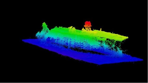
Using sonar, they mapped a structure that is 800m across with about 10m of relief.
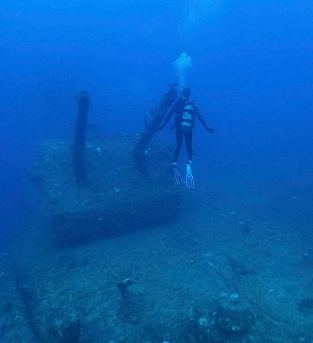
A diver examines one of the deck gun mounts aboard the USS Saratoga
"It seems as if Captain Marvel herself has punched the planet and put a dent into it," Dr Trembanis told reporters here at the American Geophysical Union meeting where he is presenting the team's investigations.
"We wanted to draw back the curtain and be able to really reveal this scene," he told BBC News.
"It really wasn't until the late '80s, early '90s, when divers could get into the area.
And at that time, they could only take a limited look at a few different wrecks.
"We were using advanced sonar technology; we could paint the entire scene.
It's a bit like visiting the Grand Canyon with a flashlight versus going in the middle of the day and illuminating the whole area.
"We could start to see the arrangement of the ships; we could see how they were aligned relative to each other; and we could see that this crater still remains - nature is still showing us this wound that it received from the bomb."
The rear of the carrier USS Saratoga is in the stages of collapse
Image : Dr Arthur Trmbanis
Remarkably, the crater has a rippled structure that looks a bit like rose petals.
It's evidence of all that material initially thrown into the sky then falling back down through the water column and spreading out across the seafloor.
Part of the motivation for the survey was to understand the continuing environmental impacts better.
Although radiation levels are much reduced, there is an ongoing pollution problem coming from the sacrificial ships.
These vessels - old units from the US, Japanese and German navies - were not prepared with the expectation that they would become artificial reefs.
If that was the intention, they would have been stripped down.
This slope map brings out the patterned structure of Baker crater
CSHEL University of Delaware
Instead, the war-game scenario demanded that they should be left in position as if operational.
That meant they were fuelled and even had munitions aboard.
"As we were mapping, I could know without looking up when we were near the [US aircraft carrier] Saratoga, because we could smell the bunker fuel; it was so heavy and is still streaking out.
"The Nagato - which was the Japanese flagship that [Admiral Isoroku] Yamamoto used to plan the attack on Pearl Harbor - had a streak of fuel coming out from it for many miles."
As the ships continue to disintegrate in the water, this pollution could become a much bigger problem, Dr Trembanis said.
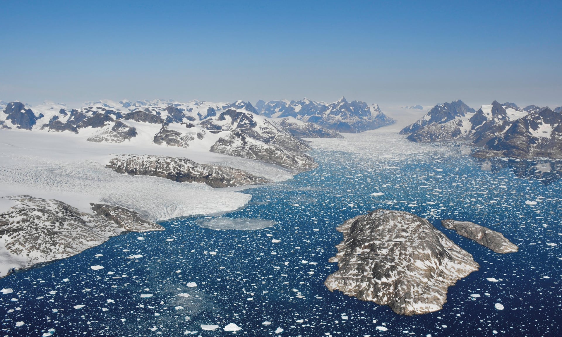
Glaciers calving icebergs in south-west Greenland, which has lost 3.8tn tonnes of ice since 1992, and the rate of ice loss has risen from 33bn tonnes a year in the 1990s to 254bn tonnes a year in the past decade.
Greenland’s ice sheet is melting much faster than previously thought, threatening hundreds of millions of people with inundation and bringing some of the irreversible impacts of the climate emergency much closer.
Greenland is losing ice seven times faster than in the 1990s and is tracking the Intergovernmental Panel on Climate Change’s high-end climate warming scenario, according to new research published in the journal Nature by an international team of polar scientists co-led by Professor Andrew Shepherd Leeds’ School of Earth and Environment.
Ice is being lost from Greenland seven times faster than it was in the 1990s, and the scale and speed of ice loss is much higher than was predicted in the comprehensive studies of global climate science by the Intergovernmental Panel on Climate Change, according to data.
That means sea level rises are likely to reach 67cm by 2100, about 7cm more than the IPCC’s main prediction.
Such a rate of rise will put 400 million people at risk of flooding every year, instead of the 360 million predicted by the IPCC, by the end of the century.
#Greenland ice losses are tracking the @ipcc_ch’s worst-case global warming scenario, which predicts 5 to 12 cm more sea level rise by 2100. This is happening now and it’s time to act. Trust political leaders who are prepared to debate #ClimateChange. Read our paper in @Naturepic.twitter.com/H8PiBztLyd
Sea level rises also add to the risk of storm surges, when the fiercer storms made more likely by global heating batter coastal regions.
These impacts are likely to strike coastal areas all around the world.
“These are not unlikely events or small impacts,” said Andrew Shepherd, professor of earth observation at the University of Leeds, one of the lead authors of the study.
“[These impacts] are happening and will be devastating for coastal communities.”
Greenland has lost 3.8tn tonnes of ice since 1992, and the rate of ice loss has risen from 33bn tonnes a year in the 1990s to 254bn tonnes a year in the past decade.
Greenland’s ice contributes directly to sea level rises as it melts because it rests on a large land mass, unlike the floating sea ice that makes up much of the rest of the Arctic ice cap.
About half of the ice loss from Greenland was from melting driven by air surface temperatures, which have risen much faster in the Arctic than the global average, and the rest was from the speeding up of the flow of ice into the sea from glaciers, driven by the warming ocean.
A glimpse into the lives of three Greenlanders: a hunter, a ship’s captain and a fisherman, individuals whose very existence and heritage is intertwined with the Arctic Ocean.
Like many who live in the polar north, their fortunes straddle the extremes of summer and winter.
Faced with a drastically changing environment, these seafarers reflect on their past, their present and uncertain future with a complex mix of emotions
Oceans have absorbed most of the excess heat arising from our disruption of the climate to date, and much of the carbon dioxide, but they are reaching the limits of their capacity to do so.
Sea level rises are driven not only by melting ice but by the thermal expansion of the seas as they warm.
The scale and speed of the ice loss surprised the team of 96 polar scientists behind the findings, published on Tuesday in the journal Nature.
The Ice Sheet Mass Balance Inter-comparison Exercise comprised 26 separate surveys of Greenland from 1992 to 2018, with data from 11 different satellites and comparisons of volume, flow and gravity compiled by experts from the UK, Nasa in the US, and the European Space Agency.
Erik Ivins, of the Nasa Jet Propulsion Laboratory in California, stressed that the findings – the most comprehensive survey yet of the ice sheet over the past few decades – were based on observations, rather than computer modelling.
“While computer simulation allows us to make projections from climate change scenarios, the satellite measurements provide prima facie evidence,” he said.
The peak year for ice loss, according to the observations, was 2011 when 335bn tonnes of ice were lost.
Since then, the average rate has slowed to 238bn tonnes a year from 2013, but this does not include the most recent observations from this summer, which showed even more widespread melting.
New research finds the Arctic’s oldest and thickest ice is more mobile and is vanishing twice as fast as ice in the rest of the Arctic.
The new study in AGU’s journal Geophysical Research Letters finds ice in the Arctic Ocean north of Greenland is more mobile than previously thought, as ocean currents and atmospheric winds are likely transporting the old, thick ice found there to other parts of the Arctic.
As a result, ice mass in the area – the last place researchers think will lose its year-round ice cover – is declining twice as fast as ice in the rest of the Arctic, according to the new findings.
This visualization shows the age of the Arctic sea ice between 1984 and 2019.
Younger sea ice, or first-year ice, is shown in a dark shade of blue while the ice that is four years old or older is shown as white.
A graph displayed in the upper left corner quantifies the area covered by sea ice four or more years old in millions of square kilometers.
Rachel Kennerley, a climate campaigner at Friends of the Earth, said: “We’re in a climate emergency – the impacts are coming thicker and faster every day.
This latest research is yet more in an ever-growing pile of evidence which shows we need real action, not warm words.
Governments need to stop dragging their feet and deliver real emissions cuts and real support for vulnerable people already experiencing the devastating effects of climate breakdown.”
The IPCC is the gold standard for climate science, but some experts are concerned that its findings do not take into account the potential for “tipping points”, thresholds beyond which climate breakdown accelerates and becomes catastrophic and irreversible.
Louise Sime, a climate scientist at the British Antarctic Survey, said of the new paper: “This finding should be of huge concern for all those who will be affected by sea level rise.
If this very high rate of ice loss continues, it is possible that new tipping points may be breached sooner than we previously thought.”
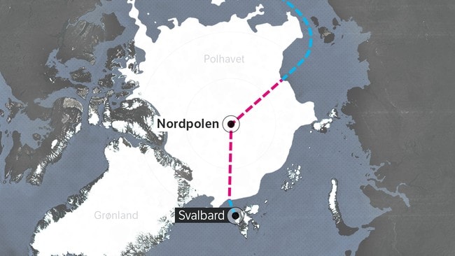
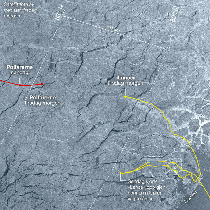
Two explorers who trekked hundreds of miles at the North Pole and were running out of food have reached safety after an epic journey across the ice.
Ever since we left the boat, Borge Ousland and I have had one set goal in mind: Reaching the North Pole!
Now that we have finally made it, we take the time to think and look back at the journey it took us to get here.
We left Alaska with Pangaea two months ago and sailed as far north towards the pole where Borge and I waved goodbye to the crew and started our expedition at 85 degrees north.
Now, a month after the drop off, we stand on top of the world, grateful for being here living our shared dream.
But the pole is only halfway, and not even, now it’s time for us to keep up the pace and make our way towards Norway, where Pangaea is waiting patiently to pick us up once we have completed our Arctic crossing!
A massive thank you to Woodkid and his team for letting us use this amazing song that describes me and my way of living so perfectly.
And bravo to the talented Etienne Claret for his hard work and commitment in the creation of this short film, which we are very happy to share with you today!
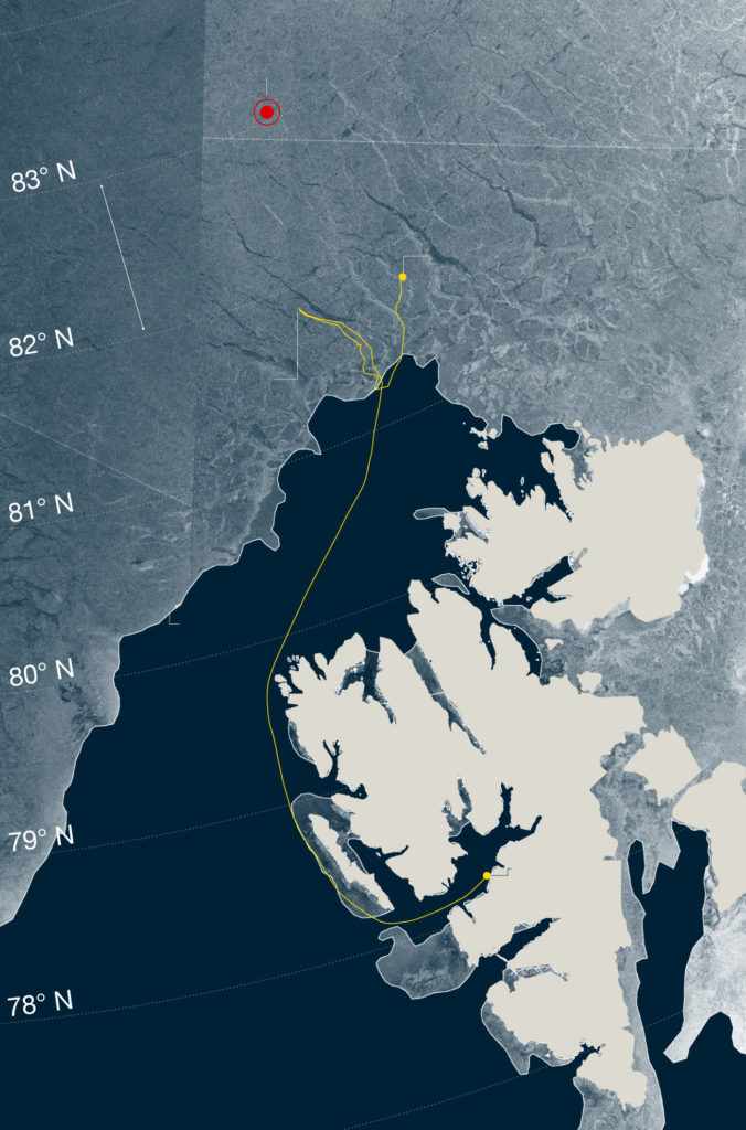
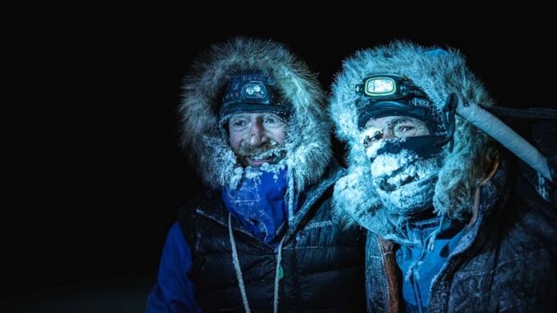
South African Mike Horn and Norwegian Boerge Ousland covered about 1,800km (1,120 miles) on treacherous drifting ice in the past couple of months.
Børge Ousland and Mike Horn cross the entire Arctic Ocean from Alaska to Svalbard, first by boat (blue line), then by ski (red line) and then by boat again (blue line).
Graphic : Joakim Digernes-Nordstrom / NRK
images : Tom Byermoen (VG)
Because of delays, they had been expected to run out of food by Friday.
However, they managed to meet up with two Norwegians sent to rescue them despite a local storm.
photo : Nick Cobbing
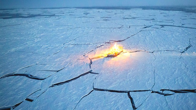
Lance ship, photo by Jørgen Braastad
The latest Instagram update on Sunday showed a picture of the four men on their way to the Norwegian polar research ship, the Lance, which was due to pick them up.
An earlier entry described how the two pairs had got closer and closer to each other until they spotted each other's headlamps in the distance and began shouting "cries of joy".
The men are now recuperating on the Lance, which will make its way out of the ice to the Pangaea, another ship which will collect them to bring them back to Svalbard, a Norwegian Arctic archipelago.
The Norwegian pair - Bengt Rotmo and Aleksander Gamme - set off on Tuesday, carrying food for the Horn-Ousland team.
Expedition organiser Lars Ebbesen, who was maintaining contact with both teams via satellite phone, told the BBC on Friday that the Horn-Ousland team did not want to be rescued by helicopter, but that they agreed to meet up with the Norwegian pair.
At that point, the wind was building up and they had little food.
If they had got trapped, they would not have had enough food to last.
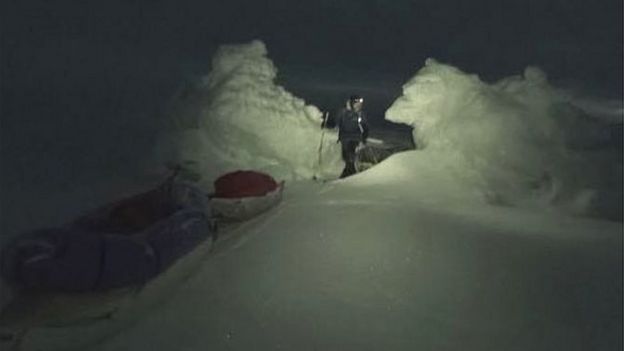
The pair faced many obstacles during their journey, including frostbite and extreme fatigue
The pair set off on 23 September and should have completed their trek in mid-November.
They spent weeks alone on the ice in the dark - in the Arctic winter, there is no daylight.
The pair faced many obstacles, including fluctuating temperatures on the ice - from -40C to +2C (35F), a sign of climate change, according to Horn.
Sometimes at night, when they were camping, the drifting ice moved them backwards, adding to the distance they had to cover.
Thinner polar ice than normal also added to the risks and slowed them down.
At one point, Horn fell into the icy water resulting in frostbite to his hands and nose.
The pair had lost a lot of weight, and were feeling weak and tired by the end of the journey, he said.
A key aim of the expedition was to collect data on the Arctic ice melt, which scientists attribute to global warming.
The journey began on the Alaskan side of the North Pole and was due to end in Svalbard.
The explorers crossed the polar ice sheet in darkness and bitter cold
Mike Horn, 53, became famous after completing a solo journey around the equator without motorised transport in 1999-2000.
In 2004, he completed a two-year solo circumnavigation of the Arctic Circle, and in 2006, along with Borge Ousland, became the first man to travel without dog or motorised transport to the North Pole during winter, in permanent darkness, according to his website.
The world’s oceans are gasping for breath, a report issued Saturday at the annual global climate talks in Madrid has concluded.
The report represents the combined efforts of 67 scientists from 17 countries and was released by the International Union for Conservation of Nature.
It found that oxygen levels in the world’s oceans declined by roughly 2 percent between 1960 and 2010.
The decline, called deoxygenation, is largely attributed to climate change, although other human activities are contributing to the problem.
One example is so-called nutrient runoff, when too many nutrients from fertilizers used on farms and lawns wash into waterways.
The decline might not seem significant because, “we’re sort of sitting surrounded by plenty of oxygen and we don’t think small losses of oxygen affect us,” said Dan Laffoley, the principal adviser in the conservation union’s global marine and polar program and an editor of the report.
“But if we were to try and go up Mount Everest without oxygen, there would come a point where a 2 percent loss of oxygen in our surroundings would become very significant.”
“The ocean is not uniformly populated with oxygen,” he added.
One study in the journal Science, for example, found that water in some parts of the tropics had experienced a 40 to 50 percent reduction in oxygen.
“This is one of the newer classes of impacts to rise into the public awareness,” said Kim Cobb, a climate scientist and director of the global change program at Georgia Tech, who was not involved in the report.
“And we see this along the coast of California with these mass fish die-offs as the most dramatic example of this kind of creep of deoxygenation on the coastal ocean.”
This loss of oxygen in the ocean is significant enough to affect the planetary cycling of elements such as nitrogen and phosphorous which are, “essential for life on Earth,” Dr. Laffoley said.
“What surprised me was that, as oxygen levels lowered, there would be an effect on those cycles,” he added.
“We lower these oxygen levels at our peril.”
Deoxygenation is just one of the ways the world’s oceans are under assault.
As they absorb carbon dioxide, oceans becomes less basic and more acidic, in some places dissolving the shells of acquatic life like clams, mussels and shrimp in what is sometimes called the “osteoporosis of the sea.”
And, since the middle of last century, oceans have absorbed 93 percent of the heat associated with human-caused greenhouse gas emissions, leading to mass bleaching of coral reefs.
Warmer water also takes up more space than cooler water.
NASA says that this thermal expansion process has caused roughly a third of existing sea level rise.
According to Dr. Laffoley, if the heat absorbed by the oceans since 1955 had gone into the lower levels of the atmosphere instead, land temperatures would be warmer by 65 degrees Fahrenheit, or 36 degrees Celsius.
Tuna is under threat from deoxygenation.
(Randy Wilder/Monterey Bay Aquarium/PA Wire)
Global average temperatures have risen 2 degrees Fahrenheit since the late 19th century and the Paris Climate agreement has a target of limiting further increases to below 3.6 degrees Fahrenheit.
But water holds less oxygen by volume than air does.
And as ocean temperatures increase, the warmer water can’t hold as much gas, including oxygen, as cooler water.
(It’s why soda tends to go flat faster in the hot summer sun.)
Warming temperatures also affect the ability of ocean water to mix, so that the oxygen absorbed on the top layer doesn’t properly get down into the deeper ocean.
And what oxygen is available gets used up more quickly because marine life uses more oxygen when temperatures are warmer.
“The ocean is a blue heart on the planet. It’s a majority of the living space on the planet and it’s kind of the center of our life support system,” Dr. Laffoley said.
“And I think we need to really look after it because it has been looking after us.”
Deep sea diving in Boston Massachusetts, United States of America.
Full titles read: "HUMAN FISH - breaks record for deep sea diving - new armoured diving suit enables diver to descend 360 feet."
M/S Scene on the deck of a ship. Crewmen surround the deep sea diver as he prepares to go overboard.
He is wearing a ridiculously designed swimsuit imaginable, ( it looks like some kind of alien from a 50's B-movie!) the suit is of metal construction and is incredibly clumsy and heavy looking.
C/U The Helmet is put into place over the diver and attached to the suit with large bolts.
M/S Some amusing scenes follow, the crewmen attach the diver onto a winch and hoist him off the deck.
M/S He is lowered tentatively to the surface of the water.
He is lowered right down until his head is completely submerged, before being pulled back to safety.