Saturday, March 30, 2013

Scientists capture amazing views of the Great Barrier Reef


From CNN

Doing for our oceans what Google Street View has done on land, a team of marine scientists is building up an extraordinary picture of the world's coral reefs.
Armed with the latest camera technology, the Catlin Seaview Survey is taking marine science into uncharted waters in a bid to transform our understanding of one of the planet's most diverse, but endangered eco-systems.
The team has been mapping Australia's Great Barrier Reef since last September using deep water robots and a revolutionary camera called the Seaview SVII.
"I think the SVII is a game changer," says lead scientist, Ove Hoegh-Guldberg. 

 Extraordinary creatures from the reef

"It's automating high-definition images at a scale which has not been done before."
As well as taking 360-degree images every three seconds, the camera also records the exact location and direction of a photo using GPS, enabling scientists to accurately gauge the health of a reefs over time.

"So far we are only halfway through Catlin Seaview Survey expeditions, but we've collected almost a hundred kilometers of transects," Hoegh-Guldberg added.
"You just can't do that normally. You'd be taking a hundred years to do this with normal divers out there with normal cameras. So, getting that technology right has been incredibly important."
More than 50,000 photos in total will be taken during expeditions to 20 separate reefs with each image stitched together using special software.
A picture of reef life is already emerging with many locations available to view on Google Earth.

Heogh-Guldberg was one of the first marine biologists to link coral damage to climate change.
And while he and others have been monitoring the effects of climate change on reefs for decades, they've never been able to do it on such a large scale.
"We don't have that global baseline for how reefs are doing across the planet. Coral reefs exist in over 50 countries and they stretch across much of the tropics and subtropics. There's 375,000 kilometers of reef around the world," says Hoegh-Guldberg.


When the three-year project is completed, reef data will have been boosted considerably, he says.
"This is the sort of science we need to do right now to get a real picture of the risk
Ove Hoegh-Guldberg, Catlin Seaview Survey
Monitoring some of the world's remotest reefs will enable scientists to more accurately answer when, where, and most importantly why coral reefs around the world are declining.

"One of the parts of the project is to create essentially a databank called 'The Global Reef Record,'" says Hoegh-Guldberg.
Huge amounts of digital video and physical measurements are being fed into a high-speed storage system, he says, and will be available to scientists all over the world.
"One of the legacies of the Catlin Seaview Survey is to create essentially that baseline information that everyone has the rights to use and then develop this complex picture of how the world is changing," he says.
"This is the sort of science we need to do right now to get a real picture of the risk and vulnerability to things like global change to coral reefs."

Friday, March 29, 2013

Marine Litter Extraction : a teen innovator thinks he has a solution for plastic pollution in our oceans


19-year-old Dutch engineering student Boyan Slat devises plan to rid the world’s oceans of 7.25 million tons of plastic


The Ocean Cleanup Array project would then sell the retrieved particles at an estimated profit. But the plan has already draw the ire of some biologists who fear for sea life that may become entangled during the plastic recovery process.

Sometimes it takes big ideas to solve big problems.
A 19-year-old Dutch aerospace engineering student has come up with what he believes is a way to remove millions of pounds of plastic trash from the world’s oceans.
Dubbed the Ocean Cleanup Array, Boyan Slat’s concept involves anchoring 24 sifters to the ocean floor and letting the sea’s own currents direct the plastic bits into miles of booms, or connected chains of timbers used to catch floating objects.
What started out as a college paper earned Slat the Best Technical Design award from Delft University of Technology.

 Problem: The plastic is not static, it moves around.
Solution: Why move through the oceans, if the oceans can move through you?
Fix the sea water processors to the sea bed, and save vast amounts of funds, manpower and emissions.

From the start, Slat said he was motivated to get to work by the very scope of the problem facing the world.
“It will be very hard to convince everyone in the world to handle their plastics responsibly, but what we humans are very good in, is inventing technical solutions to our problems,” Slat said on his website. “And that’s what we’re doing.”
Powered by the sun and ocean currents, the Ocean Cleanup Array network aims to have as little impact on sea life as possible while sifting out some 7.25 million tons of plastic over the course of just five years.
The bulk of the ray-shaped sifters and booms would be set up at the edges of the five swirling ocean gyres to trap the most plastic particles possible.

 Problem:Oceanic 'Garbage Patches' are huge, and cleaning them up would result in huge amounts of by-catches.
Furthermore there is a huge variety in debris sizes.
Solution: By using floating booms instead of nets, much larger areas will covered.
No mesh means that even the smallest particles will be diverted and extracted. No mesh - together with its low speed - will result to virtually no by-catch.
Although this hypothesis still has to be tested, even the planktonic species - due to their density being close to that of the sea water - may move under the booms along with the water flow.

Able to function in high seas and rough weather, the booms would trap floating plastic bits, then suck them into a trash sifter.
Once the plastic is retrieved, Slat envisions, it will be brought ashore and sold.
“This concept is so efficient, that we estimate that by selling the plastic retrieved from the 5 gyres, we would make in fact more money than the plan would cost to execute. In other words; it's profitable,” Slat’s website states.

Problems: A clean-up operation would generate significant emissions. Besides that, in high seas much plastic would escape.
Solution: The platforms will be completely self-supportive, receiving their energy from e.g. the sun, currents and waves.
And by letting the platforms' wings sway like an actual manta ray, we can ensure contacts of the inlets with the surface, even in the roughest weather.

The plan is not without its critics, however.
“Ships on fixed moorings and thousands of miles of booms (because the scale of this is also improbable) have the potential to create a lot more marine debris, and seem particularly hazardous to entanglement-prone marine life.”
Biologist Miriam Goldstein wrote on the University of Washington’s “Marine Debris Listserv
Goldstein also raised questions about whether plankton, or small and microscopic life, would be killed by the sifting process.

 Problem: Conventional clean-up ideas have never been financially realistic, let alone remediation of millions of square kilometres.
Solution: This concept is so efficient, that we estimate that by selling the plastic retrieved from the 5 gyres, we would make in fact more money than the plan would cost to execute. In other words; it may potentially be profitable.

For Slat, however, it’s full speed ahead.
The wunderkind founded The Ocean Cleanup Foundation earlier this year and is looking to partner with plankton biologists, engineers, and, of course, philanthropists to turn his dream into a reality.

"The last couple of days several (spontaneous) articles have been published, claiming The Ocean Cleanup Array is a 'feasible method' of extracting plastic from the gyres.
This is an incorrect statement; we are currently only at about 1/4th of completing our feasibility study. Only after finishing that study, we believe such statements should be made. Although the preliminary results look promising, and our team of about 50 engineers, modellers, external experts and students is making good progress, we had and have no intention of presenting a concept as a feasible solution while still being in investigative phase.
Please stay tuned for this study, which will be published online in several months' time.
We kindly request the press to refrain from any further publication, until all assumptions of this concept have been confirmed."

Thursday, March 28, 2013

To control floods, the Dutch turn to nature for inspiration


The Sand Motor is a huge volume of sand which will be applied in 2011 along the coast of South-
Holland at Ter Heijde.
Trailing suction hopper dredgers deposit the dredged sand from the sea on land via rainbowing or through a pipeline.
Infl uenced by wind and water the sand gradually spreads along the coast of South-Holland.
This is called 'Building with Nature'.
The Sand Motor will gradually change in shape and will eventually be fully incorporated in the dunes and the beach.
The coast will be broader and safer.

From YaleEnvironment360

The Netherlands’ system of dikes and sea gates has long been the best in the world.
But as the country confronts the challenges of climate change, it is increasingly relying on techniques that mimic natural systems and harness nature’s power to hold back the sea.

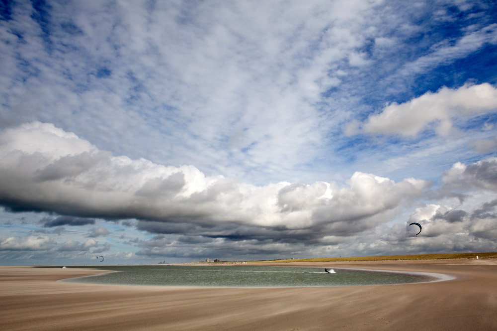
On a freezing winter day along the south-central coast of Holland, two beachcombers, hunched against the wind, stroll along a crescent of sand extending more than half a mile into the North Sea.
Nearby, a snowkiter skims over the 28 million-cubic-yard heap of dredged sediment spreading along the shore.
If all goes as planned, the mound will eventually disappear, rearranged by ocean currents into a 12-mile-long buffer protecting the coastline for the next two decades.
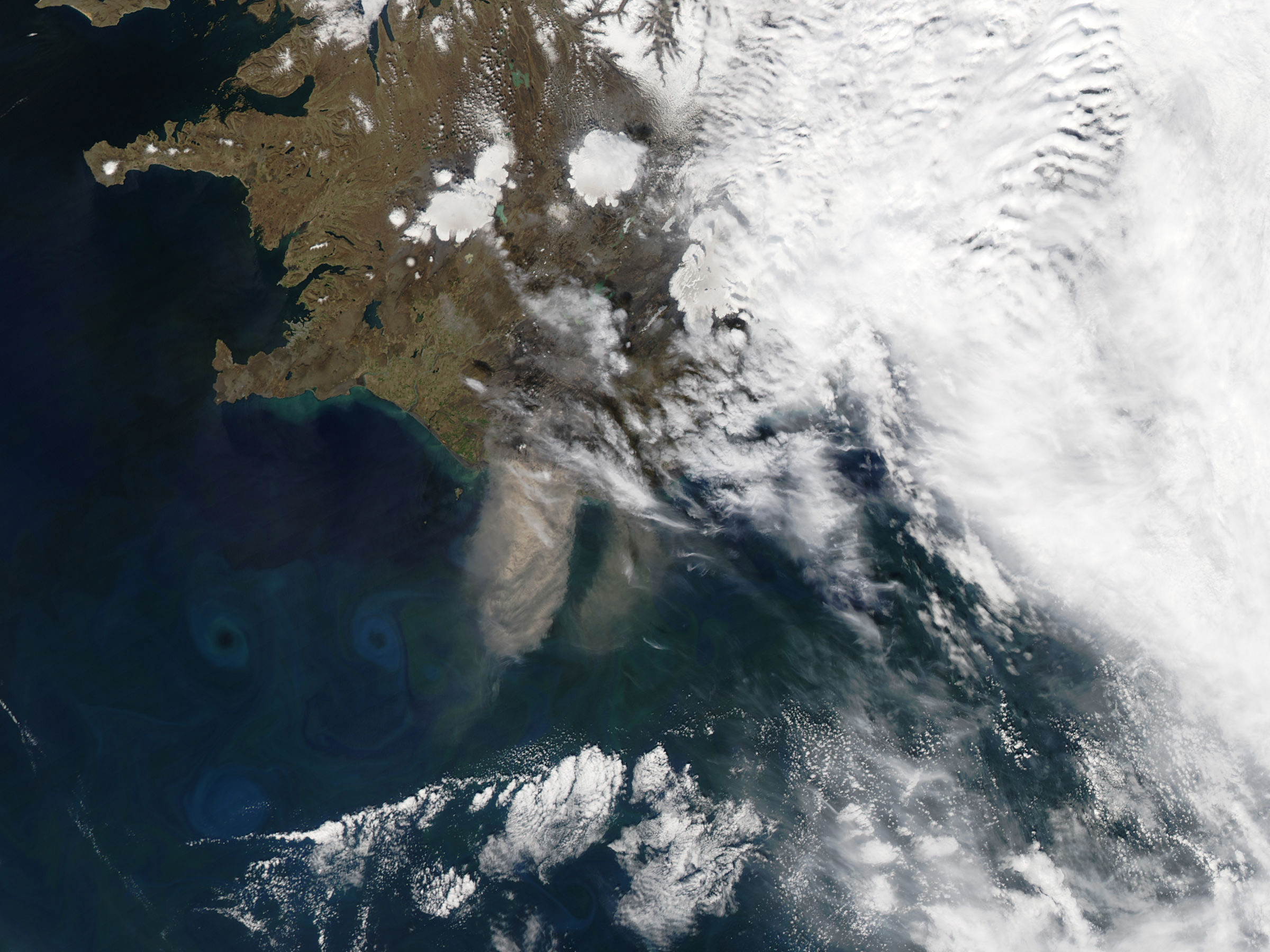
 >>> geolocalization with the Marine GeoGarage <<<
Between March 2011 and October 2011, Rijkswaterstaat and the provincial authority of Zuid-Holland created the hook-shaped peninsula.
It extends 1 km into the sea and is 2 km wide where it joins the shore."

This is the Sand Engine, one of the latest innovations from Dutch masters of flood control technology and designed, as the national water board Rijkswaterstaat says, so that “nature will take the sand to the right place for us.”
After having constructed the country’s vaunted system of sea gates and dikes, Dutch planners and engineers are now augmenting it with new technology enlisting nature to keep the water at bay.

“Normally, there is a lot of erosion here,” says hydraulic engineer Mathijs van Ledden, sweeping an arm toward the snow-covered spit snaking around an elongated lagoon.
Van Ledden is a flood risk reduction specialist with Royal HaskoningDHV, a Dutch engineering consultancy involved in creating the Sand Engine, currently 2.2 miles wide.
“This big reservoir of sand should re-nourish the rest of the coast in time,” he says, gesturing toward the skyline of The Hague, several miles away.

In 2011, a Dutch ship pumps material onto The Netherlands' so-called Sand Engine project, a 28 million-cubic-yard heap of sand along the coast of Holland that will be rearranged by ocean currents and fortify a 12-mile buffer to protect the coastline.
 (Photo courtesy of Rijkswaterstaat/Joop van Houdt) 

The Sand Engine is the signature project of Building with Nature, a consortium of Dutch industries, universities, research institutes, and public water agencies looking to harness natural systems for next-generation hydraulic engineering.
Completed in late 2011 at a cost of 50 million euros ($67 million), the Sand Engine’s goal is to provide long-term fortification for eroding beaches as ocean currents gradually redistribute its dredged material.
Until now, this coastline needed sand replenishment every five years, requiring expensive dredging that damaged marine ecosystems.
The Sand Engine will feed beaches for about 20 years at half the price, said Marcel Stive, chair of coastal engineering at Delft University of Technology (TU Delft) and principal creator of the technology.
“At this moment, this is the safest coast we have,” Stive said.
When the sand is fully spread out, it will protect 20 kilometers (12.4 miles) of shoreline from the current rate of sea-level rise, he said. If the amount of water increases, “we’ll just add more.”

 The Sand Engine, as seen in 2012.
The project is part of "Building with Nature," a consortium of Dutch industries, universities, research institutes, and public water agencies that is seeking to mimic natural systems and harness nature's power to hold back rising seas.
(Photo courtesy of Rijkswaterstaat/Joop van Houdt)

With sea levels climbing — many coastal experts are projecting rises of 3 to 5 feet this century — and climate change expected to boost storm frequency and intensity, flood protection is an increasingly pressing issue worldwide.
And at the forefront of flood-control technology are the Dutch, long aware of the damage that surging oceans and overflowing rivers can wreak in their low-lying country.
Hydraulic engineering has been underway here since the Middle Ages, and the country’s 16.7 million residents have “dry feet” thanks to a network of dikes, canals, and engineering marvels like the Maeslant Barrier near Rotterdam: two floating gates, each the length of the Eiffel Tower, that automatically close to shield the city and its major port when a North Sea storm surge threatens.

Managing water is big business in The Netherlands: Dutch hydraulic engineers and related industries brought in around 7.5 billion euros ($10 billion) in 2008 from projects around the world, according to the most recent figures available from the Netherlands Water Partnership.
But while the Dutch export their high-tech engineering prowess worldwide — designing gigantic, mechanical structures like London’s Thames Barrier — at home the future of flood-defense encompasses a return to basics: utilizing natural materials, mimicking natural systems, and harnessing nature’s power to protect this vulnerable nation.

A so-called "Smart Dike," which contains embedded sensors that relay real-time status reports on the condition of the dike to decision makers.
Early notice of a developing problem could give officials time to make repairs or enable residents to evacuate in advance.
(Photo courtesy of Deltares)

Projects like the Sand Engine illustrate the potential and challenges in flood-risk management, said Jos Maccabiani, a geotechnical engineer with the nonprofit applied research institute, Deltares, and program secretary of Flood Control 2015, a national initiative to improve flood management.
In addition to being cost-effective, new infrastructure must minimize environmental impacts and be adaptable to changing climate conditions.

“How do you build these structures in a way that can be easily upgraded later without too much cost?” he asked. “This is a challenge that we are really working on right now.”

One solution is employing living organisms as natural buffers.
A mangrove forest, for instance, “has a tendency to catch sediments and grow with sea level rise,” said Deltares marine biologist Mindert de Vries, “whereas these sandy solutions are losing sand all the time.”
De Vries, an eco-engineering expert, is designing hybrid dikes, planting vegetation such as willows on the seaward side to absorb the ocean’s first blows.
The dike itself can then be lower, less expensive, and more durable than a traditional dike. De Vries estimates it cuts costs around 30 percent.
“The new dikes for the new century,” he calls them. “The soft solution.”

Construction of the Sand Motor (also known as Sand Engine) in the Netherlands, how it works and scientific research

Nature is also being recruited to turn existing dikes into ecologically enhanced “rich levees” that mimic rocky coasts, providing habitat for marine organisms.
Adding roughness to the dike’s seaward face dampens waves and reduces overtopping, said Jasper Fiselier, an environmental planner with Royal HaskoningDHV and a Building with Nature project leader.

To give nature a helping hand, Dutch researchers are working on new dike materials like flexible cement to attach energy-absorbing stones, geotextiles that prevent internal erosion — a major cause of breaches — and super-strong grass that dampens wave action.
One intriguing process strengthens dikes with “bio grout” produced by bacteria fed a substance that makes them excrete calcium.
So far, it only works on a small scale.

Zandmotor

The new designs provide a longer-term solution than barriers, proponents say.
“If I make a [concrete] dike, and conditions change, I have to re-do the whole dike,” Fiselier said.
“Whereas with a soft defense, I only have to put a half-meter [of earth] on top.”

The Netherlands is now considering a host of eco-engineered structures in a proposed 1 billion euro ($1.34 billion) package of flood-protection upgrades.
Several are already in the works, including replacing the country’s tallest dike, near Hondsbossche, with a sand dune, and shoring up an aging dam in the eastern delta with a small sand engine.

The country’s first hybrid dike is now being built near Dordrecht.
Incoming waves will lose power in a flooded willow forest before they reach the dike.
“The dike is going to be much softer and lower, because you get the waves out,” de Vries said.
“You get nature in front.”
Other countries, including Singapore and Vietnam, have expressed interest in the new designs, according to de Vries.

 In the Dutch seaside resort of Scheveningen, authorities are building a new dike protected by a widened beach and concealed beneath an undulating pedestrian- and bicycle-friendly esplanade. (Photo courtesy of The Hague)

Building with nature is a special challenge in urban areas, said Matthijs Kok, a flood-risk professor at TU Delft and a member of the environmental consulting firm HKV Consultants.
His solution is multifunctional levees, which combine ecological, recreational, and economic functions with flood control.
“It sounds very easy,” Kok said, “but it’s not. Because there are so many stakeholders, so many interests.”
To satisfy the various interests, businesses such as restaurants and hotels, public facilities like swimming beaches and hiking paths, and natural areas are being integrated into flood-control projects.
One such example, now under construction at the seaside resort of Scheveningen, is a new dike protected by a widened beach and concealed beneath an undulating pedestrian- and bicycle-friendly esplanade.

But using nature to fight floods is not a panacea.
Dunes and plants take up more room than traditional dikes.
Moreover, faced with the larger storms and swollen seas predicted for the future, natural defenses may not always have enough muscle.

“Let’s be honest about it,” said van Ledden.
“A forest is not going to protect you against a surge of six or eight meters [20 to 26 feet], so there are limits.”

In addition to bolstering flood defenses with enhanced natural systems, Dutch scientists and engineers also are working to “improve the decision-making when things might go wrong,” said Maccabiani. To that end, Deltares is developing Smart Dikes — sensor-embedded levees that relay real-time status reports via cell towers to decision-makers.
The purpose is to give “more time to react when you see something inside the dike that is happening while you don’t see anything on the outside yet,” Maccabiani said.
Early notice of a developing problem could give time for repairs or let residents evacuate well in advance.

The system is currently in the test stage, and Maccabiani said discussions are underway with the U.S. Army Corps of Engineers and several American universities to set up a pilot project in the Mississippi delta.

Another high-tech project underway at Deltares is 3DI, which uses LIDAR, a three-dimensional laser imaging system, to map out underground water-storage capacity.
The system, projected for rollout in 2014, will pinpoint flood-prone spots and places where excess water, such as runoff from heavy rains, can be accommodated.

Many areas of the U.S., including the coasts of Southern California, Florida, and New Jersey, would also benefit from natural or soft defenses, according to de Vries and others.
But so far, the new designs have gotten little attention across the Atlantic.
American engineers are “very much into building dikes and hard structures,” de Vries said.
“And the nature people — well, these worlds don’t know each other.”

The new Dutch technology has promise, and flood management agencies in the U.S. are keeping an eye on it, said Jason Needham, a consequence specialist with the U.S. Army Corps of Engineers’ Risk-management Center in Davis, Calif., who recently spent a year in the Netherlands on a staff-exchange program.
But sophisticated devices like Smart Dikes are expensive, and haven’t yet proven their worth, he said.
As for natural defenses, Needham said the concepts are good, and “everyone agrees our wetlands need to be restored.”

The two countries have different approaches to flood control, Needham acknowledged, with the Dutch focusing mainly on prevention, while Americans emphasize emergency preparedness and recovery.
In the face of an uncertain future climate, however, the objectives are now converging.
The goal, as Needham puts it, is “how to get people safer without putting a big wall up there.”

Links :
  • FlickR :  Zandmotor's photostream

Wednesday, March 27, 2013

James Cameron gives deep sea sub to science

Hollywood director James Cameron donates his record-breaking submarine to science to promote marine research

From BBC

The sub that took Hollywood director James Cameron to the deepest place in the ocean is being donated to science.

On the first anniversary of his 10.9km solo descent of the Mariana Trench, Mr Cameron told the BBC that he was giving the Deepsea Challenger to the Woods Hole Oceanographic Institution, US.

Initially, parts will be used as add-ons for other subs, but the entire system could dive again in the future.
Mr Cameron said he would like to return to the controls himself at some point.
"I'd like to go dive the sub again," he explained.
"There are a number of really, really interesting science targets out there. I would love to see the Deepsea Challenger dive in the Tonga Trench, the Kermadec Trench and the Sirena Deep (a 10.7km-deep part of the Mariana Trench)."

The director said that the ocean was a vast unexplored frontier, but that funding cuts were now jeopardising research.

When Mr Cameron made his dive in 2012, he became the first person to reach the bottom of the Mariana Trench, which is in the western Pacific Ocean, for 50 years - and the only person to have ever made the descent alone.

 Precedent: Jacques Piccard and Don Walsh emerge from the bathyscaphe Trieste following their successful manned descent to the bottom of the Mariana Trench in January 1960

The only previous manned dive to this deepest spot, called the Challenger Deep, was carried out by US Navy Lt Don Walsh and Swiss oceanographer Jacques Piccard.
They took the plunge to the deepest point in the ocean in a bathyscaphe called Trieste in 1960.

It took Mr Cameron just two hours to reach the seafloor.
While his bright green submersible moved through the water like a vertical torpedo, the director was squeezed into a tiny chamber that kept him safe from the colossal pressures that exist almost 11km down.
While at the bottom, he spent several hours exploring the seafloor. 3D cameras captured images for a National Geographic film that is being released later this year.

He told the BBC that donating the vessel to the Woods Hole Oceanographic Institution (WHOI) would give the sub "a second phase" of life after the dive.
He said that funding was so scarce that plans to take the vehicle on a second series of dives had not been possible.
He explained: "I'd love to keep the Deepsea Challenger continuously operational. But I think that what I'm going for right now is what I call 'potentially operational'. The way to do that is to preserve the hardware 100%, which we'll do, but more importantly to preserve the culture of the engineering.
"My hope is with the sub's home now at Woods Hole, there will be a residential team in place - and they will have the knowledge of how to bring that sub back online."


New thinking

WHOI is one of the world's foremost research centres dedicated to ocean science.
It already operates a a number of submersibles including the famous Alvin vehicle.

Initially, Woods Hole will use some of the components in Mr Cameron's sub to supplement its own vessels.

The lights and cameras from Deepsea Challenger will be installed on Nereus, an unmanned underwater vehicle that has also explored the Mariana Trench.
Dr Dave Gallo, director of special projects at WHOI, said the next stage would be to work out what other technology might be of use - and whether the submersible could be used again.

He added: "It is for one person, so you would have to have someone trained to do it - and we are looking very closely at every option."

The filmmaker said more money should be put into ocean science - and that it was essential to explore the biology and the chemistry of the deepsea.

The preliminary science results of the dive, which were released at the American Geophysical Union's Fall Meeting in San Francisco, suggest that the team had found many species that are new to science.


The presented results came from Mr Cameron's dive to the Challenger Deep in the Mariana Trench; an earlier dive to the New Britain Trench, off the coast of Papua New Guinea; and footage and samples taken from landers in the Sirena Deep.

The director told BBC News: "As an absolute minimum, (there were ) over 68 new species - most are bacteria, some are amphipods, and there is possibly a new sea cucumber... and that number may go way up.
"There were also some quite interesting new species of giant amphipods that were 7-8in long when amphipods are normally 0.5-1in in size."

But the explorer said he was surprised there were so little visible signs of life in the Mariana Trench.
"We expected there to be a big biomass in the sediment... but I expected more macrofauna, the things crawling around on the bottom. I had never seen a seafloor as devoid of macrofauna as the Challenger Deep.

"Is it because of the depth? Is it because it is so far from land and there is very little happening in the water column directly above it?"

Further exploration, he said, with the Deepsea Challenger and other robotic vessels would be the only way to find the answers.

Links :

Tuesday, March 26, 2013

Overfished and under-protected: Oceans on the brink of catastrophic collapse

The world's oceans are facing a bleak future, say marine scientists, unless we rebuild its abundance, variety and vitality.

From CNN

As the human footprint has spread, the remaining wildernesses on our planet have retreated. However, dive just a few meters below the ocean surface and you will enter a world where humans very rarely venture.

In many ways, it is the forgotten world on Earth.
A ridiculous thought when you consider that oceans make up 90% of the living volume of the planet and are home to more than one million species, ranging from the largest animal on the planet -- the blue whale -- to one of the weirdest -- the blobfish.

Remoteness, however, has not left the oceans and their inhabitants unaffected by humans, with overfishing, climate change and pollution destabilizing marine environments across the world.

Many marine scientists consider overfishing to be the greatest of these threats.
The Census of Marine Life, a decade-long international survey of ocean life completed in 2010, estimated that 90% of the big fish had disappeared from the world's oceans, victims primarily of overfishing.
"Anywhere you go and try to harvest fish with a trawl you are going to destroy any coral that lives there, and there is example after example of the damage that is done by trawlers
Ron O'Dor, senior scientist on the Census of Marine Life

Tens of thousands of bluefin tuna were caught every year in the North Sea in the 1930s and 1940s. Today, they have disappeared across the seas of Northern Europe.
Halibut has suffered a similar fate, largely vanishing from the North Atlantic in the 19th century.

In some cases, the collapse has spread to entire fisheries.
The remaining fishing trawlers in the Irish Sea, for example, bring back nothing more than prawns and scallops, says marine biologist Callum Roberts, from the UK's York University.
"Is a smear of protein the sort of marine environment we want or need? No, we need one with a variety of species, that is going to be more resistant to the conditions we can expect from climate change," Roberts said.

The situation is even worse in Southeast Asia.
In Indonesia, people are now fishing for juvenile fish and protein that they can grind into fishmeal and use as feed for coastal prawn farms. "It's heading towards an end game," laments Roberts


(Bottom trawling is) akin to someone plowing up a wildflower meadow, just because they can," says Callum Roberts, marine biologist at the UK's York University.Others have compared it to the deforestation of tropical rainforests.

Trawling towards disaster

One particular type of fishing, bottom-trawling, is blamed for some of the worst and unnecessary damage.
It involves dropping a large net, around 60 meters-wide in some cases, into the sea and dragging it along with heavy weights from a trawler.

Marine conservationists compare it to a bulldozer, with the nets pulled for as far as 20km, picking up turtles, coral and anything else in their path.
The bycatch, unwanted fish and other ocean life thrown back into the sea, can amount to as much as 90% of a trawl's total catch.

Upwards of one million sea turtles were estimated to have been killed as by catch during the period 1990-2008, according to a report published in Conservation Letters in 2010, and many of the species are on the IUCN's list of threatened species.

Campaigners, with the support of marine scientists, have repeatedly tried to persuade countries to agree to an international ban, arguing that the indiscriminate nature of bottom-trawling is causing irreversible damage to coral reefs and slow-growing fish species, which can take decades to reach maturity and are therefore slow to replenish their numbers.

"It's akin to someone plowing up a wildflower meadow, just because they can," says Roberts.
Others have compared it to the deforestation of tropical rainforests.

Bottom-trawling's knock-on impacts are best illustrated by the plight of the deep-sea fish, the orange roughy (also known as slimeheads) whose populations have been reduced by more than 90%, according to marine scientists.

"The disturbing truth is that humans are having unrecognized impacts on every part of the ocean, and there is much we have not seen that will disappear before we ever get a chance".
Ron O'Dor, marine biologist

Bottom-trawling's knock-on impacts are best illustrated by the plight of the deep-sea fish, the orange roughy (also known as slimeheads).Populations have been reduced by more than 90%, according to marine scientists.

Orange roughys are found on, or around, mineral-rich seamounts that often form coral and act as feeding and spawning hubs for a variety of marine life.

"Anywhere you go and try to harvest fish with a trawl you are going to destroy any coral that lives there, and there is example after example of the damage that is done by trawlers," says Ron O'Dor, a senior scientist on the Census of Marine Life.
"If I ruled the world, they would be banned, they're just such a destructive method of catching fish. Fishermen have other methods, such as long-line, that cause far less damage.
"The disturbing truth is that humans are having unrecognized impacts on every part of the ocean, and there is much we have not seen that will disappear before we ever get a chance," says O'Dor, who is also a professor of marine biology at Dalhousie University in Halifax, Canada.

Despite an increased awareness of overfishing, the majority of people still know very little about the scale of the destruction being wrought on the oceans.
This film presents an unquestionable case for why overfishing needs to end and shows that there is still an opportunity for change.
Reform of the EU's Common Fisheries Policy is almost complete.
Fisheries ministers and members of the European Parliament, MEPs, are negotiating a deal for the future EU fisheries subsidies, which should support and end to EU overfishing.

Acid test for marine species

At the same time fisheries and vital marine ecosystems like coral are being decimated, the oceans continue to provide vital services, absorbing up to one third of human carbon dioxide emissions while producing 50% of all the oxygen we breathe.

But absorbing increasing quantities of carbon dioxide (CO2) has come at a cost, increasing the acidity of the water.

"The two worst things in my mind happening to oceans are global warming and ocean acidification," says O'Dor,
"They're going to have terrible effects on coral reefs. Because of acidification essentially, the coral can't grow and it's going to dissolve away."

The ocean has become 30% more acidic since the start of The Industrial Revolution in the 18th century and is predicted to be 150% more acidic by the end of this century, according to a UNESCO report published last year.

"There's a coral reef off Norway that was discovered in 2007 and it's likely to be dead by 2020," says O'Dor.
"The problem is that the acidification is worse near the Poles because low temperature water dissolves more acid. Starting from the Pole and working south these reefs are going to suffer extensively."

Current estimates suggest 30% of coral reefs will be endangered by 2050, says O'Dor, because of the effects of ocean acidification and global warming.

Higher acidity also disrupts marine organisms' ability to grow, reproduce and respire.
The Census of Marine Life reported that phytoplankton, the microscopic plants producing most of the oxygen from the oceans, have been declining by around 1% a year since 1900.

"We need to fish less and in less destructive measures, waste less, pollute less and protect more
Callum Roberts, Marine biologist

The falling numbers of smaller, but lesser known species and plant life has significant impact further up the marine food chain.
For example, seabirds which used to visit and breed on Spitsbergen -- a Norwegian island near the Arctic -- are being wiped out because of changes in their previously abundant food sources

Tons of dead fish float on the waters of the Rodrigo de Freitas lagoon, beside the Corcovado mountain in Rio de Janeiro, Brazil.Threats from pollution, overfishing and climate change are putting marine life under immense strain.

Bringing law and order to ocean protection

"There's a real lack of public and political awareness of these issues," says Alex Rogers, professor of conservation biology at the UK's Oxford University.
"They're too big to understand in economic terms. We can put a value on the loss of fishing, but how can we put a value on oxygen production or the absorption of carbon dioxide?" he says.

The problem is that most of the world's ocean is located outside of international law and legal control.
Any attempts to implement rules and regulation come with the problem of enforcement, says Rogers, who is also scientific director of the International Program on State of the Ocean (IPSO).

Marine conservationists estimate that at least 30% of the oceans need to be covered by marine protected areas, where fishing and the newly emerging deep-sea mining of valuable minerals on the seabed, is banned or restricted.

Callum Roberts, who helped form the first network of marine protected areas in the high seas in 2010, says on their own they are not enough.
"I could sum it up as: we need to fish less and in less destructive measures, waste less, pollute less and protect more," says Roberts.
"This change of course will see us rebuild the abundance, variety and vitality of life in the sea which will give the oceans the resilience they need to weather the difficult times ahead. Without such action, our future is bleak."

Links :

Monday, March 25, 2013

Iceland volcano eruption fueled ocean blooms

The plume of ash and steam rising from the Eyjafjallajokull volcano reached 17,000 to 20,000 feet (5 to 6 kilometers) into the atmosphere on May 10, 2010, when the Moderate Resolution Imaging Spectroradiometer (MODIS) on NASA's Aqua satellite captured this image.
CREDIT: Jeff Schmaltz, MODIS Rapid Response Team at NASA GSFC

From OurAmazingPlanet

The explosive volcanic eruption Iceland saw in 2010 may have disrupted life in the air above Europe, but it apparently enriched life in the Atlantic Ocean, researchers say.

After nearly two centuries of dormancy, the volcano Eyjafjallajökull (AYA-feeyapla-yurkul) erupted many times over the course of 10 weeks three years ago.
These outbursts spewed a giant plume of ash that spread unusually far and stayed for an oddly long time in the atmosphere,forcing widespread flight cancellations for days.

Serendipitously, marine biogeochemist Eric Achterberg at the University of Southampton in England and his colleagues were taking part in a series of research cruises in the Iceland Basin region of the North Atlantic Ocean both during and after the eruption.
These three cruises allowed the researchers to measure iron concentrations at the ocean's surface before, during and after the eruption in areas directly influenced by the plume of iron-rich ash.

"This was really the first time scientists have been under a volcanic plume at sea and could really look at the immediate effects of the ash falling into the ocean," Achterberg said.
"That was really exciting, doing something that's never been done before." [Gallery: Iceland Volcano's Fiery Sunsets]

Ash plume from Eyjafjallajokull Volcano, Iceland May 26h 2010 View
The ash is blowing over the North Atlantic Ocean.
The ocean itself is colored with subtle swirls of blue and green, revealing the presence of a large phytoplankton bloom.
While volcanic ash can fertilize ocean waters in parts of the world where waters contain little iron, the North Atlantic already contains more than enough iron to sustain large phytoplankton blooms.
This bloom is part of the large phytoplankton bloom that covers much of the North Atlantic every spring and summer.

Ocean bloom

Iron is key to ocean life, helping spur the growth of single-celled organisms known as phytoplankton. Like plants, these organisms convert sunlight to chemical energy via photosynthesis and serve as the base of the food chain.
In about a third of the global ocean, a scarcity of iron limits the abundance of life, so ash supplying this metal could spur booms in biological activity.

Beneath the plume, the scientists found that peak dissolved iron levels were up to about 20 to 45 times higher after the plume than they had been before the ash came along.
A model of ash dispersal rate that the researchers developed, along with measurements of iron dissolution, suggest that up to 220,000 square miles (570,000 square kilometers) of North Atlantic waters might have been seeded with up to about 100 metric tons of iron.

The researchers also saw that after the eruption, levels of another nutrient, nitrate, were nearly completely depleted in the central Iceland Basin.
That finding suggests that when volcanic iron fertilized the waters, the resulting phytoplankton bloom sucked up other nutrients as well.

Since phytoplankton use carbon dioxide just like plants do, volcanic ash falling on the ocean could reduce levels of the greenhouse gas in the atmosphere.
However, the team estimated that the plume from Eyjafjallajökull only triggered a 10 to 20 percent rise in carbon dioxide uptake by phytoplankton in the Iceland Basin compared to other years.
In order for volcanic iron to have larger effects on the atmosphere, phytoplankton must really flourish.
For that to happen, the researchers suggest, ash emissions have to be much larger and longer in duration and must occur over a region high in nitrate.

 Eruption of Eyjafjallajökull Volcano, Iceland
NASA image acquired May 18, 2010

Blow to geoengineering

The relatively modest effects that this volcanic iron apparently had on atmospheric carbon dioxide levels strike another blow against so-called geoengineering schemes that aim to reduce levels of greenhouse gases by adding large amounts of iron to the seas.

"I'm not an advocate of dumping into the ocean to remove atmospheric carbon dioxide," Achterberg said. "It's not a very efficient process.
You'd need so much iron to remove the man-made carbon dioxide emitted at the moment that it wouldn't be worth it."

In the future, researchers could investigate the effects of volcanic ash on the Southern Ocean, which is relatively rich in nitrate.
"There, you might see more of an effect when you add extra iron via ash," Achterberg said. "However, you'd have to be lucky to be at sea when a volcano erupted there. Our cruise was scheduled three years in advance, and it was just pure luck we were in the Iceland Basin when Eyjafjallajökull erupted."

The scientists detailed their findings online March 14 in the journal Geophysical Research Letters.

Links :
  • DailyClimate : Seeding ocean with volcanic iron did little to lower CO2 – study

Sunday, March 24, 2013

Building the Triple-E


Maersk and the Discovery Channel have joined forces to bring you every phase of constructing the 400-meter long Triple-E vessel.
Visit http://worldslargestship.com/ to see more on the biggest container ship ever built.

Discovery Channel goes behind the scenes and into shipyards to explore the entire construction of the Triple-E, from the initial steel cutting ceremony to its maiden voyage.