This time lapse footage was made while I worked on containership MV Carat in
North Europe going around the Baltic Sea.
During the trip we went from
Riga, Latvia to Tallinn, Estonia to Klaipeda, Lithuania, Gdynia, Poland,
then to the other side of Europe through the Kiel Canal to Hamburg and
Bremerhaven, Germany.
This was a a very fast paced environment,
sometimes as little as eight hours sailing between ports and many berth
shifts while loading and unloading cargo.
Note the precise shiphandling
while maneuvering the ship and without any assistance of the tug boats.
Over 15,000 photos were used to put this video together, all summed up
in five minutes.
At first sight the great slabs of
grey-blue ice covering the Arctic Ocean appear to be rock-solid and
immobile but the extraordinary fact is that they are restless and
shifting.
Beneath what appears to be an unbending and endless landscape, the winds and currents are constantly at work reshaping it.
During
the long dark months of the past winter, Norway's research vessel, the
Lance, has been stationed amid the floes and drifting with them at the
amazing speed of half a mile an hour.
In the few days I spent on
board, when the vessel seemed to be locked in a vice-like grip, we
actually travelled about a dozen miles.
The view was essentially
unchanging but the satellite navigation system revealed the extent of
the drift and the Lance's journey can be seen here.
Although
deploying the latest technology, the expedition's use of ice drift is
not an original idea but instead draws on the proud legacy of one of the
greatest ventures in polar discovery more than a century ago - the
voyage of a vessel known as the Fram under its leader, Fridtjof Nansen.
Nansen
wanted to test what was then an unthinkable notion - jamming a ship
into the ice and letting the flow of the ice do the rest.
Nansen wanted to jam a ship into the ice and let drift do the rest "I demolish my bridges behind me - then there is no choice but forward."
Go with the floe
He
and others had noticed that old timbers from northern Russia were
washing up several thousand miles away on the shores of Greenland - and
the only possible explanation was that winds and currents had carried
them there.
Scientists now call this feature as the Transpolar Drift.
And
when an American vessel, the Jeannette, was crushed in the ice off
Siberia in 1881, there was huge surprise when identifiable parts of the
wreckage also turned up in Greenland.
That led Nansen to dream up
the idea of using the natural mobility of the ice to achieve something
that was impossible at the time - to penetrate what he called the
"ramparts of ice" and reach the North Pole.
The movement of the ice, he judged, was sometimes "so strong and rapid as to equal that of a ship running before the wind".
Fridtjof Nansen believed that working with the forces of nature would pull the expedition through "Alas! Alas! Life is full of disappointments; as one reaches one ridge
there is always another and a higher one beyond which blocks the view.'
Nansen concluded that a vessel of the right shape - with a tough
rounded hull - would be squeezed upwards as the ice closed around it,
and be lifted above the surface to avoid destruction.
"I believe
that if we pay attention to the actually existent forces of nature, and
seek to work with and not against them, we shall thus find the safest
and easiest method of reaching the Pole," he wrote.
"The ship will
simply be hoisted up and will ride safely and firmly…the current will
be our motive power, while our ship, no longer a means of transport,
will become a barrack."
Initially, his concept was met with
derision.
In 1892, when he outlined his plan to the Royal Geographical Society in London, the big names of polar exploration lined up to
dismiss it.
On Nansen's Steps
In 1893, Nansen took a special round-hulled ship Fram to the New
Siberian Islands in the eastern Arctic Ocean, froze her into the pack
ice, and waited for the Arctic drift to carry her towards the pole.
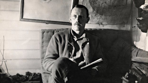
Impatient with the slow pace and erratic nature of the drift, after 18
months Nansen and Johansen, left the ship with a team of dogs and
sledges and made for the pole.
They did not reach 90°N but they achieved
a record north latitude of 86°13.6′N before a long and parlous retreat
over ice and water, attacked by bear and walrus, to eventually reach the
safety of Franz Josef Land, where they overwintered in 1895.
In 1896,
Nansen and Johansen were found and rescued by Jackson.
(Of course, the
ironies are in that where Nansen froze himself in the ice, we now break
it to reach the pole; where he tried to utilize lean Inuit and Sami
icefaring styles, we nowadays do so with full nuclear-powered icebreaker
and helicopter bandobust.)
Dire warnings
The
legendary figure of Admiral Sir Leopold M'Clintock, who had led the
first expedition through the fabled North West Passage in the Canadian
Arctic, warned Nansen that "the danger of being crushed in the ice was
too great." Sir Allen Young, another giant of Arctic discovery,
highlighted the fact that no one knew whether land or islands lay in the
unknown reaches of the Far North and that the idea of drifting would be
"extremely dangerous".
The American explorer General Greely went
even further, warning that the expedition would fail with the risk of
"suffering and death among its members".
In 1893, when Nansen and
his team set off, the growth of winter ice quickly surrounded the Fram
and the moment of truth arrived.
The ice floes jostled around the ship
and a loud creaking began.
"Now both pressure and noise gets worse
and worse; the ship shakes, and I feel as if I myself were being gently
lifted with the stern-rail, where I stand gazing out at the welter of
ice-masses that resemble giant snakes writhing and twisting their great
bodies out there under the quiet starry sky."
Other explorers warned that the crew risked suffering and death through their bold endeavour
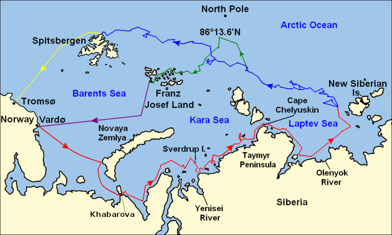
The theory worked.
The Fram rose, and its well-built frame and
multi-layered hull withstood what no one other vessel had managed
before.
The result was that for three years the ship inched
generally northwards and westwards, sometimes driven back, sometimes
stationary, but proving that the Arctic is an active, restless region.
The
ship did not make it to the Pole so Nansen and a crewmate ventured
towards it on foot and attained the previously-unheard of latitude of 86
degrees North, where massive ridges of ice blocked their path.
The
two of them, and the Fram, returned safely, and Nansen became an
instant hero.
Norway witnessed the largest gathering of people ever seen
at that moment in its history, a significant moment for a country then
yearning for its independence from Sweden.
Map of Fridtjof Nansen's 1888 route across Greenland, the first crossing of the island.
(in blue) Dotted line is the ship Jason's journey from Iceland to near Sermilik fjord (now known as Sermiligaaq), continuous blue line is the journey made by Nansen and his companions in two small boats trying to reach the coast.
(in red) Planned journey from Sermilik northwest to Christianhaab (today known as Qasigiannguit).
(in green) Nansen's actual journey across Greenland from Umivik fjord to Gothaab (today known as Nuuk).
And in the years that
followed, Nansen emerged as the essential expert for others to consult
before any major expedition.
His fellow Norwegian, Roald Amundsen, the
first man to reach the South Pole, and the British explorers Scott and Shackleton, all went to see him.
So how have things changed since Nansen's day?
The
Lance is built of steel rather than the wood used for the Fram but it
has the same rounded shape which serves the same purpose.
On one
occasion last February, the Lance's bow rose nearly a metre into the air
as the ship was lifted by an underwater ice-floe.
And during our stay I
felt a slight tilt as that process was at work again.
Map of the Arctic Ocean showing the routes taken during the 1893–96 Nansen's Fram expedition:
(in red) Fram's route eastward from Vardø to the Siberian coast,
turning north at the New Siberian Islands to enter the pack ice. July –
September 1893
( in blue) Fram's drift in the ice from the New Siberian Islands, north and west to Spitsbergen, September 1893 – August 1896
(in green) Nansen and Johansen's march to Farthest North, 86°20'N,
and their subsequent retreat to Cape Flora in Franz Josef Land. February
1895 – June 1896
(in purple) Nansen and Johansen's return to Vardø from Cape Flora, August 1896
(in yellow) Fram's voyage from Spitsbergen to Tromsø, August 1896
The
scientists on the Lance are measuring everything from the weather to the
ice to the creatures beneath it.
Nansen, with cruder instruments, did
the same, establishing some guiding principles for methodical
observation.
One of his major revelations was that the Arctic Ocean is
extremely deep.
For any researchers working on the Lance, there's a
rotation off the ship every six weeks by helicopter.
By contrast, for
the men on the Fram, there was no escape for three long years from
1893-6.
The clothing has improved immeasurably. Everyone
venturing onto the ice now has to wear a floatation suit and during our
worst weather, when the wind chill was minus 47C, it was just about
possible to work outside.
Nansen and his men, in a mix of wolf-skin and
wool, must have felt the cold terribly and, if they slipped into the icy
water, they just got soaked.
The Fram withstood forces that no other vessel had managed before "The difficult is what takes a little time; the impossible is what takes a little longer."
And there's also been a huge cultural shift in how the polar wildlife is regarded.
These
days, the scientists go to great lengths to avoid harming any creature
that comes their way.
So polar bears, which can be a dangerous threat,
are scared away with snowmobiles or flare guns; rifles are a last
resort.
Instead, in Nansen's time, the animals of the Arctic were
seen as a source of food, as a means of survival. Seals, walruses and
even polar bears were not just fair game but essential stock for the
larder.
It may be shocking to read this now but Nansen was quite
open in his account of the voyage: "We have eaten bear-meat morning,
noon, and night, and so far from being tired of it, have made the
discovery that the breast of the cubs is quite a delicacy."
At the end of his journey, Nansen wrote that he had "gone far to lift the veil of mystery" over the Arctic.
He
also suggested that future expeditions should repeat his technique of
using ships because the explorers would be more comfortable and could
also bring their laboratories with them.
That is exactly what the Norwegian Polar Institute has done with the Lance, as if following his script.
But
one can only guess at what Nansen would make of the helicopters and
computers and other new technology, and of how the Arctic itself is
being transformed.
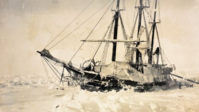
Fridtjof Nansen - A man of action and vision
Born in Norway in 1861, Fridtjof Nansen was a scientist, polar explorer,
diplomat, statesman and humanist, with a deep compassion for his fellow
human beings. "It is better to go skiing and think of God, than go to church and think of sport."
Andrew Taylor, an amateur sailor, taking part in
the 9th Clipper round the world yacht race, aboard the 70' ocean racing
yacht 'Derry LondonDerry Doire'.
Fell overboard during horrific weather
conditions and was lost at sea for 1hour and 40minutes in the very
middle of the icy cold North Pacific.
The crew of the yacht were totally
alone in their search and the eventual dramatic recovery of Andrew, who
was deeply hypothermic when recovered.
This book sets the scene as to
how Andrew initially came to be competing in the race, his team’s
eventful and truly amazing journey yacht racing over 45,000 miles around
the world.
The epic story of his desperate fight for survival in the
North Pacific.
Andrew's miraculous, surprising, and almost immediate
return to ocean yacht racing.
All sales proceeds from this book go to charity, split equally between;
The Ellen MacArthur Cancer Trust and The Newmarket Day Centre
The British sailor who fell overboard in the North Pacific during the Clipper Round The World Yacht Race has written a book detailing his terrifying near-death experience
The first thing that struck me was the silence.
Just moments before I’d been on the foredeck of a 73ft racing yacht, face-to-face with my skipper but screaming to be heard over howling 60mph winds and whipping rain.
A winter storm was blowing in, turning the sky black.
We were rushing to change to a smaller headsail in time.
Suddenly, a huge wave smashed into the side of the boat and sent me tumbling headfirst into the freezing North Pacific.
I braced myself for the safety line fixing me to the boat to tauten. It didn’t.
The yacht ploughed on past at 25 knots, its rudder smashing into my legs
so hard that I was convinced both had been broken.
Then the boat was
gone, swallowed up by the gloom, the waves, the rain and spray.
It was
just me: gasping for breath and fighting to stay afloat in the 30 metre
swells of the most inhospitable ocean on earth.
I was 2,000 miles from
land, on map coordinates I will never forget: 179W.
This August, I will be standing on the banks of the Thames watching a fleet of a dozen yachts embark on the 11th Clipper Round the World Yacht Race,
a 40,00 mile odyssey that takes 10 months.
It will be an exhilarating
sight. I know, because two years ago I was part of one such flotilla. The race very nearly cost me my life.
Like many taking part in this year’s event, I signed up for
the adventure.
I was 46, divorced, and had been working as a catering
director at the Olympic Park and, prior to that, at Wembley Stadium for a
decade.
I was exhausted and had decided to take a year off.
Amazing rescue at sea, man almost dead, crazy rescue in the water, Speed clipper race at sea, man almost dies drowned.
Circumnavigating the world was a massive personal decision, even aside
from the cost – a place this year is £48,000.
I would not see my
teenange daughter Siobhan or my parents for almost a year.
And I had no
sailing experience. The Clipper race involves a rigorous selection process and intensive training in the months leading up to the race start.
You learn that life aboard a racing yacht is hard work mentally and
physically, gruelling at times and often dangerous.
You are reliant on
yourself and your fellow crew members.
For many weeks, you will be far
from land and from rescue services.
It is not something to be undertaken
lightly but it was what I wanted: the pleasure of working as a team;
the thrill of escape.
I was assigned to the yacht Derry-Londonderry–Doire - each boat is named after a sponsoring city or region in the world
- and skippered by the 32-year-old Sean McCarter.
There were 10 ‘‘round
the world crew’’ on board and we’d be joined by ‘‘leggers’’,
individuals who had signed up to do one or more of the 16 legs of the
race, joining at the start or on one of the eight stopovers across the
world.
We had already sailed the Southern Ocean, as well as the notoriously
unpredictable waters of the Bass and Taiwan straits and, between us we
had suffered a broken arm, ribs, fingers, shoulder blade, and a
dislocated shoulder.
Leg 10, however, was the part of the race everybody
was dreading.
The route took in 5,600 nautical miles between Qingdao in
China and San Francisco - a month-long journey through seas known as the
most violent on earth.
The nights were so dark you couldn’t even see
the waves crashing over the boat.
The isolation was total, just endless
boiling sea in every direction.
At 179W, the international space station
is only 250 miles above.
M.O.B. 'Man Overboard' 41°43.213N / 179°11.451W Possibly one of the remotest points on earth!
Man overboard
The day it happened
was March 30, my mum’s birthday.
I’d been on deck since 5am and it was
an hour before I was due to go off watch at midday.
I cannot properly
describe the hideous, sickening realization that I wasn’t clipped on to
the boat - a standing order in rough weather and especially when working
on the pitching, tossing fore-deck.
The impact of the
cold was instant, the sea temperature being no more than two degrees.
Even though I was wearing a dry suit (which provides thermal insulation
in water) I began to feel the iciness seep in, gnawing at my extremities
and the small of my back.
Had I not been wearing the suit I would have
been dead in minutes. Clipped to my life jacket was an AIS beacon,
a device which once activated would alert those on the boat I was in
the water and help them to locate me.
I had bought it myself before the
trip and now it was my only hope.
I reached down into the water and
turned it on, praying that the signal to the boat would be picked up and
alert them to my position.
I clutched the beacon as tight as possible
in my hand and tried as hard as I could to stop being tossed like a rag
doll between the waves.
I thought about my daughter Siobhan and missing my mum’s
birthday.
My life didn’t flash before my eyes, though.
I was too intent
on not swallowing water and struggling to breathe.
When the storm that
had been threatening hit in all its fury, it was like being in a washing
machine: wave after wave smashed down upon me.
I remember seeing the
boat a few times and realizing they had stopped.
At one point I could
see someone was up the mast which at least confirmed they were looking
for me.
But it was obvious they were some miles away.
One hour in I realized I had stopped shivering.
I knew from my race
training this was a prelude to the euphoric feeling associated with the
advanced stages of hypothermia.
I did everything to fight it, even
taking my spray hood off and turning into the wind to get cold again.
I
had a watch on but I never once looked at it because I thought it would
only demoralise me.
At some point I decided to reboot my beacon - and
thank God I did.
This time it flashed differently and I realised it
hadn't been working properly before and the boat may not have picked up
my signal.
Perhaps this time.....
Over the course of that dreadful 100 minutes in the ocean I had all
kinds of mental experiences, some real, some the product of my battered
consciousness.
At times I was shouting at myself to keep fighting and
stay alive.
Even now, I can’t bear to read what I’ve written about it or
remember it.
When I first head voices - snatches of
shouting on the wind - I wasn’t sure if it was my imagination. Then the
boat was on top of me – all 36 tonnes of it crashing up and down the
waves, both a wonderful and terrifying sight.
That
wasn’t the end of the ordeal, though.
In training we had, many times, practiced lowering a rescuer from the boat to clip a helicopter strop on
to the man overboard and then haul him out.
But the conditions that day
were so bad that the rescue swimmer, a friend of mine called Jason
Middleton, couldn’t get the clips on to me.
Twice, I fell back into the
water and the boat had to go around again in a figure of eight to
re-start the rescue.
Finally, after several attempts, the clip snapped
shut, but at that moment the boat rolled back and forth violently and it
smashed me repeatedly against the side.
I was convinced I was going to
drown.
One more attempt and several crew members were leaning over
in a desperate attempt to pull me up by hand and get me onboard.
Eventually it was me who grabbed on to a guard rail and miraculously
haul myself in.
I will never know what gave me that final strength –
perhaps it was the instinctive knowledge that it was the last attempt
before my body succumbed.
Either way, I remember being in a heap face
down on the deck.
I turned and looked up at the skipper and he had this
massive smile on his face.
He said: “Hey Andrew we’re going to San
Francisco, fancy a lift?”
I was still in grave danger.
If I had been on land I would have been in intensive care.
I was put in a
sleeping bag surrounded by bottles full of hot water, and Susie
Redhouse, a paramedic from London who was the boat medic, stayed with me
as I started to warm up – refusing to let me sleep.
I had severe shock
and hypothermia, my face was was covered in abrasions from the saltwater
and my battered legs in agony.
But the principal fear was of secondary
drowning when your lungs flood.
The simple process of warming up was the
most intense pain I’ve ever experienced as if my skin was on fire.
It was 12 days before we reached land.
During that time I
slept a lot, ate little, and slowly began to limp around.
Speaking to my
family over the satellite phone was just amazing.
News of the rescue
had preceded our arrival in San Francisco and there were television
crews everywhere.
I resolved then that I was going to finish the race.
I
spent six days having intense physiotherapy before rejoining the boat.
I
was, of course, worried, but quitting would have been the easy thing to
do – and that is not why I signed up.
I decided to write a book detailing my rescuenot
to make money – all proceeds are going to charity - so that others can
learn from my experience and it can help improve marine safety.
Since finishing the race last summer, I have worked closely with the
Clipper organisation and marine safety manufacturers.
We have updated
and altered the clips and straps on the rescue equipment, and we have
also changed training for man over board drills so now the rescue
swimmer actually is submerged in the water rather than being lowered
down on a halyard.
The AIS beacon has also had its software updated and
now will reboot automatically if it does not connect with the signal
onboard.
I kept my own AIS beacon and have it framed.
On a personal level, I needed to come to terms with what happened and
writing has helped me do that. It was a miracle that I survived.
I
wouldn’t miss the start of this year’s race for the world.
My experience
of being lost at sea makes me all the more determined that others
should continue to explore it.
National Geographic atlases from 1999 through 2014 shows how Arctic ice has melted over time.
North Pole Map Many nations are using bathymetric data (which maps the seafloor) to claim parts of the Arctic Ocean, including the North Pole. Russia, Canada, and Denmark have all expressed an interest in claiming the area around the pole as an extension of their continental shelves.
Map by Bill Rankin, National Geographic
Arctic Maps – Exploring the New & Unknown
What first comes to mind when you think of the Arctic?
Ice? Polar bears? Climate change?
It wasn’t until very recently that we’ve gotten a clearer picture of
the Arctic.
But just what are we mapping in the Arctic?
Geographic
boundaries, climate change, ecology, geology, trading routes, oil
exploration, the natural environment and even the research that is
taking place in the north of 60°.
Maps are one of the most effective forms of communication ever
developed.
They chart territory, they’re practical and communicate
ideas.
So that’s why this list of Arctic maps is the best place to begin
learning about the Arctic.
If you want answers about the Arctic, look
no further.
These visually-inspiring Arctic maps will show you the way.
1. ArkGIS – Mapping the Arctic Landscape
In Norwegian, ArkGIS stands for Arktisk Geografisk Informasjons System.
The World Wildlife Fund delivers a webmap to simplify the Arctic. Stakeholders, decision makers and general public get the whole picture with the ArkGIS – Mapping the Arctic Landscape Webmap.
From economic boundaries to human activity.. to the natural
environment… ArkGIS puts together piece-by-piece each element with its
Arctic maps.
Boundaries:
Exclusive Economic Zones (EEZ): Canada, Norway,
Russia, Denmark (via Greenland), and the United States (via Alaska) are
limited to their economic adjacent to their coasts. The waters beyond
is considered international water.
Human Activity:
Shipping Routes: Shipping routes are observed using the satellite-based Automatic Identification System (AIS).
Oil and Gas: Exploration and production wells used to retrieve underground petroleum or oil.
Natural Environment:
Physical Oceanography: Bathymetry shows underwater depth of the ocean floor. The SRTM30 PLUS Grid with roughly 1 km grid resolution.
Sea Ice and Snow: Variables like sea ice and snow cover is an important variable for scientists to understand the pace of climate change.
Ecology:
Marine Mammals: Distribution and observations of
marine animals are depicted for whales, seals, walruses and narwhals.
It includes polar bear status and denning areas.
Seabirds: This includes waterfowl, seabird and shorebird species richness.
Fish: From Atlantic cod to Walleye Pollock, these layers show the probability of occurrence and observations for fish species.
2. ArMap: Arctic Research Mapping Application
Arctic research mapping
Have you ever wanted to tap into all the research in the Arctic?
Thousands of research projects are taking place in the Arctic.
This is
why the Arctic Research Mapping Application
was developed.
It supports Arctic science by displaying research
projects, showing available data and exploring possible collaborations.
Projects range from biological, geological, meteorological to
oceanography.
Arctic vegetation, glaciers, permafrost, terrestrial
biomes and tree lines can be displayed.
The Arctic maps has ship
tracks, medical facilities and arctic stations are available for
reference.
Users can navigate to areas of interest and explore research
projects by location, year, funding program, investigator, discipline,
keywords, and other variables.
3. 1971 Arctic Ocean Floor
Early explorers thought the oceans were bottomless.
After the
invention of the sonic depth finder, suddenly our view of the oceans
changed.
They certainly weren’t bottomless… nor, were they flat.
The
featureless ocean became dynamic with trenches, ridges and abyssal
plains.
This Arctic Ocean Floor map
first appeared in the October 1971 issue of National Geographic.
The
detail is extraordinary of such submarine terrain as continental
shelves, abyssal plains, ridges, and fracture zones.
Land masses and the
ocean floor are illustrated in stunning relief in these Arctic maps.
4. Geologic Map of the Arctic
Canada’s Geo-mapping Frontiers project was initiated to improve
geoscience knowledge in Canada’s north. Natural Resources Canada’s Geologic Map of the Arctic displays geologic structures of Canada’s Arctic north of 60°.
This Arctic map was compiled using simple photogeologic principles
and visual interpretation from a variety of free data sources.
The data
sets included enhanced magnetic data, LANDSAT imagery and topographic
(DEM) data.
5. The Arctic Risk Map
The Arctic Risk Map
is filled with base data from a variety of sources.
It offers
meteorology, ocean, biological, wildlife, search and rescue,
geographical and activity as map data.
But where these Arctic maps
excel are in their environmental and safety indexes.
Environment Vulnerability Index: A location and
season specific index for environmental vulnerability of marine
resources with respect to oil spill as external stressor.
The
vulnerability assessment was performed for the different ecological uses
in about 100 areas of heightened ecological significance within the 17
Arctic Large Marine Ecosystems.
The Safety and Operability Index (SOI): The SOI is
based on risk influencing factors such as sea ice, visibility,
temperature, distance from search and rescue, etc.
It gives an
aggregated score for each Arctic region for safety and operability
factors in these regions.
Values are compared with the benchmark chosen
by Norwegian Sea.
The Arctic is in flux for ‘who’ is claiming ‘what’..
The US, Russia, Canada, Norway and Danish are all staking their
territory.
But no one can tap the Arctic until all countries come to an
agreement.
Mineral extraction, natural gas, as well as potential
shortcuts for shipping routes – the Arctic may be one of the last great
frontiers for human development.
NASA has some models forecasting ice-free summers in the Arctic Ocean.
Disappearing sea ice jeopardizes mammal populations like polar bears.
Polar bears have less time to hunt because of the early breakup of sea
ice.
The result is a shrinking polar bear population.
Seals, walruses
and seabirds have shorter periods for nesting and feeding.
Whether its human activity or the natural environment, these 5 Arctic maps help you truly understand the great North.
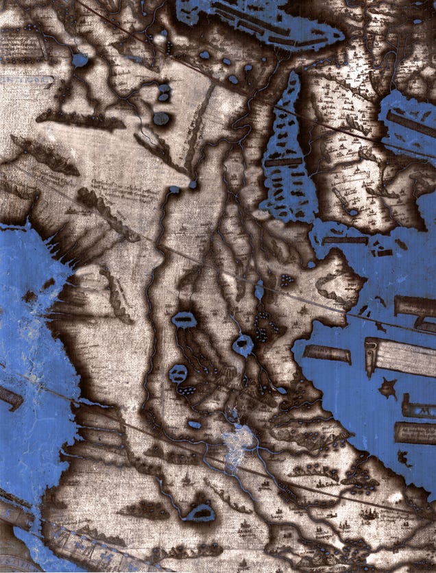
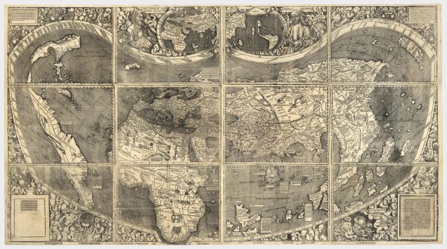
This map of the world drawn by Henricus Martellus in about 1491 was
donated to Yale in 1962. Its faded condition (shown above) has stymied
researchers for decades. The multispectral image of the map (below)
reveals text and details invisible to the naked eye.
The primary way we share ideas today is the internet.
In the 15th century, it was cartography.
And now, researchers at Yale are giving us a glimpse of one of the most influential maps in history—parts of which, up until now, had been too faded and aged to read.
Henricus
Martellus isn’t a name you’d recognize unless you’re interested in map
history, but he played a role in some of the most important events of
the early modern world, thanks to a map he drew in 1491.
It showed the
world as Europe understood it, and scholars have long theorized that it
gave Columbus the information he needed to find the New World (it also
may have famously misinformed him about the location of Japan, today
known as the Bahamas).
That a map
could survive 500 years—524 years, to be exact—is pretty amazing.
But
much of the text on the 6-foot-wide map has been lost to history thanks
to wear and tear.
Since the map came to Yale in the 1960s, researchers
have tried to decipher hundreds of words and shapes that were too faded
to read.
Text in the southern Asia portion of the map describes the "Panotii"
people, who purportedly had ears that were so large they could use them
as sleeping bags.
It’s only within the past year that they’ve succeeded—thanks to improvements in multispectral imaging.
In Yale News,
Michael Cummings explains how the technology has revealed hundreds of
new words that seemed lost forever.
In his story, he explains how a team
at Yale is using multispectral imaging to see through the ancient haze:
The process captures images of the map at 12 different light
frequencies which, when processed using imaging algorithms, reveal words
and figures where our eyes see nothing.
Cummings
was kind enough to send along higher-res versions of the maps’ new
details, a few of which you’ll find below.
As Cummings
explains, a lot of the text passages on the map describe not only local
populations, but also the local wildlife of regions throughout the
world—sometimes lifted from The Travels of Marco Polo.
For
example, the passage below is warning of a monstrous creature today
known as an Orca, which Yale says Martellus described as “a sea monster
that is like the sun when it shines, whose form can hardly be described,
except that its skin is soft and its body huge.”
A text box in the Indian Ocean warns of the orca
Another warns of “large wildernesses in which there are lions, large leopards, and many other animals different from ours:”
Text found in northern Africa
Ethiopian Sources
Another
cool detail revealed by the multispectral analysis?
That the way
Martellus depicted Africa was actually based on African sources. According to Cummings,
the way Africa is drawn on the map actually came from Ethiopian
input—specifically, “three Ethiopian delegates to the Council of
Florence in 1441.”
The council was called by the Pope—who invited the
Ethiopian delegates, providing insight into how the African continent
was shaped.
The multispectral images show previously lost details in Martellus'
depiction Africa that suggest the German cartographer used data from
African sources, not European explorations.
A Map’s Lineage
Again,
cartography was a hugely important tool during the Age of Discovery.
Martellus’s map was based on others before it, and his map went on to
influence how several other cartographers depicted the new world.
The
multispectral images created by Yale give us a look at that heritage—the
newly-uncovered words include some shared with a later map, by Martin
Waldseemüller in 1507, suggesting Waldseemüller may have used this map
to draw his own.
Of course, his 16th century America looks very
different from our own. “America” is a long, thin peninsula that seems
to stretch from Nova Scotia down to Florida.
Beyond that, neither
Waldseemüller or Martellus could know.
It would
take far longer to find out what existed in the blank patch of map—and
even longer for us to figure out what they thought might exist there.
It's no longer a challenge to get astonishingly sharp photos of the Earth from space, but video?
That's another matter.
UrtheCast is about to open the floodgates, however.
It just released the first batch of full-color, high-definition video of Earth recorded from the International Space Station.
In many ways, the extremely sharp footage (with detail down to 3.3 feet) of London is like an internet mapping site come to life -- all those pathways are suddenly full of moving boats and cars.
The Iris imaging system that recorded these movies won't be fully operational until the summer, but the preview suggests that its customers will get plenty of insights into traffic and other activity that's harder to track from the ground.
Links :
Wired : Watch Earth in Live HD video from space this summer


 This
This 


