Methane bubbles frozen in a lake in China.
The release of the gas as
Arctic ice melts could cause 1C of global warming ‘instantly’ but
geoengineering could neutralise this using an iron salt.
Photograph: Rex/Shutterstock
From The Guardian by Amy Fleming
Around the world, dozens of ingenious projects are trying to ‘trick’ the ocean into absorbing more CO2.
But critics warn of unforeseen consequencesTom Green has a plan to tackle climate change.
The British biologist and director of the charity Project Vesta wants to turn a trillion tonnes of CO2 into rock, and sink it to the bottom of the sea.
Green admits the idea is “audacious”.
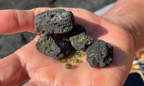
It would involve locking away atmospheric carbon by dropping pea-coloured sand into the ocean.
The sand is made of ground olivine – an abundant volcanic rock, known to jewellers as peridot – and, if
Green’s calculations are correct, depositing it offshore on 2% of the world’s coastlines would capture 100% of total global annual carbon emissions.
The plan relies on a natural process called weathering.
“Weathering has been working on the planet for billions of years,” says Green, a graduate of Harvard Business School who runs Project Vesta from San Francisco.
“When rain falls on volcanic rocks, they dissolve a little in the water, causing a chemical reaction that uses carbon dioxide from the atmosphere.
The carbon ends up in the ocean, where it’s used by marine-calcifying organisms like corals and shell-making animals, whose skeletons and shells sink to the bottom of the ocean as sediment and eventually become limestone.”
Volcanic olivine, which Project Vesta is trialling as a way to capture carbon absorbed in oceans.
Photograph: Courtesy: Project Vesta
Olivine weathers easily, and allowing ocean currents to churn it up, says Green, “will make it dissolve much more quickly, to happen on a human-relevant timescale”.
It is not a rare mineral: there are beaches in the Galapagos islands and in Hawaii that are green with olivine-rich sand.
The idea of using the sea to absorb excess carbon is not far-fetched, says Green.
Ocean water can hold 150 times more CO2 than air, per unit of volume.
“The ocean has already taken up about 30% of the excess carbon dioxide that we’ve emitted as a society,” he says.
He and his colleagues are gearing up to test their process in two similar Caribbean coves, one acting as an untouched “control” in the experiment.
There remain many unknowns.
Would such an intervention work? Who gets to decide if it should go ahead? Could there be side-effects? It is complex chemistry, and the natural process of weathering would be accelerated to an unnatural pace.
Our understanding of the workings of the ocean is a mere drop in the proverbial.
But with our race to mend the planet having taken on Sisyphean overtones, there is still hope that the vast, churning seas can be our lifeline.
Advertisement
Increasing carbon capture naturally on land – by planting trees, for example – will not remove enough CO2 to halt global heating.
Peter Wadhams, head of the Polar Ocean Physics Group at Cambridge University and author of A Farewell to Ice, says: “If you want to get rid of the industrial emissions from Europe, you’d have to turn Europe into one big primeval forest.
It works, but it’s not good enough alone.”
The problem is so large that we cannot be focused on the idea of perfection, because perfection is the enemy of goodGaurav Sant, UCLA
There are many ingenious ideas being discussed.
Coastlines could be rewilded with underwater forests of kelp or seagrass, surface water cooled by generating air bubbles to whoosh cold water up from the deep, and marine clouds sprayed with seawater to reflect more heat from the sun.
As the UK prepares to host the UN Climate Change Conference (Cop26) in November, dozens of these projects are being trialled.
Most rely on the ocean’s many natural balance-restoring processes: enhancing them to help slow cooling, to lock away carbon, to protect Arctic ice or even to reduce the threat of hurricanes.
Nobody knows if these concepts will work, or what consequences there could be.
They all qualify as geoengineering – a dirty word for some environmentalists.
Human intervention in the natural world has often gone awry: cane toads unleashed in Australia in the 1930s to protect sugar crops continue to decimate native fauna.
And there is always the prospect of high carbon-emitting industries viewing such solutions as an excuse to dodge their emission-cutting commitments and maintain business as usual.
Gaurav Sant, director of the UCLA Institute for Carbon Management, says there is no longer time to waste debating.
“What else could happen? The short answer is we don’t know, and I don’t think anybody else does either.
We’re simply going to have to do this and find out.

Prof Gaurav Sant, at UCLA, has helped to develop technology that can extract carbon dioxide from the sea, enabling the water to absorb more.
Photograph: UCLA
“The problem at hand is so large that we cannot be focused on the idea of perfection, because perfection is the enemy of good.”
Sant is referring to
another concept, which he is helping to develop just a few hundred miles down the coast from Green, where UCLA engineers have developed a machine that mimics how seashells form.
Called a flow reactor, the machine sucks seawater in, and an electrical charge makes it alkaline, which triggers the CO2 to react with the seawater’s magnesium and calcium, producing limestone and magnesite (like forming shells).
The water then flows out and, depleted of its captured CO2, is ready to take up more.
A byproduct of this process – hydrogen – can be extracted for fuel.
It’s a similar concept to weathering olivine in the ocean, and Sant’s plan is for initial small studies before a gradual scaling up.
The team aims to remove between 10 and 20 gigatonnes of CO2 from the atmosphere, starting in 2050.
Sant says it will be a huge challenge to build a system large enough – and then to build thousands more.
“Anyone saying ‘we’re going to do this in five years’, is greatly underestimating the challenge,” he says.
“We’re talking about an enormous enterprise, the size and scale of which humanity has not seen before.”
The sheer scale of geoengineering needed to tackle the climate crisis means that even well-known ideas are floundering.
The notion of boosting phytoplankton blooms, tiny floating plants that absorb CO2 when they photosynthesise, and can be helped along by nutrients, such as iron, was much mooted.
But Jean-Pierre Gattuso, research director at the Laboratoire d’Océanographie de Villefranche in Paris, says the latest research suggests the idea is not viable.
“Ocean fertilisation experiments were performed at sea demonstrating that iron addition can trigger a phytoplankton bloom,” he says.
“However, the amount of CO2 permanently sequestered appears to be small, because most of the organic matter produced is respired back to CO2before it has a chance to be stored in the deep ocean.
An unintended consequence may also be the creation of low-oxygen areas of water.”
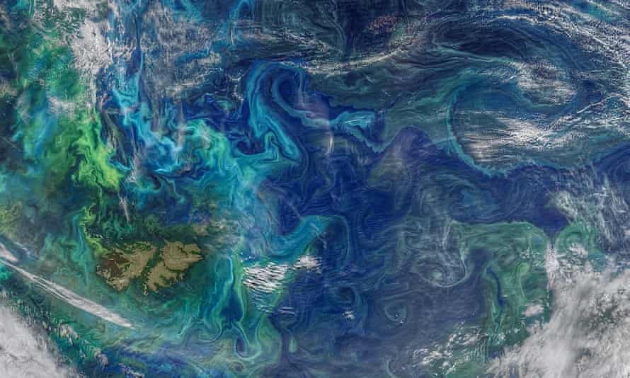 A Nasa image of the southern Atlantic Ocean showing phytoplankton blooms (in green and light blue).
The tiny plants can sequester CO2.
Photograph: Nasa/Zuma/RexAnother setback has arisen in the attempt to neutralise methane as it escapes from beneath melting Arctic ice.
Methane bubble plumes are increasingly being seen in the Arctic, and Wadhams is frustrated that the Intergovernmental Panel on Climate Change (IPCC) has not yet accepted his theory that, as the ice melts, we could face a
catastrophic escape of methanethat has been stored for 20,000 years.
Estimates, he says, range from 50 to 700 gigatonnes, which could “cause maybe a degree [centigrade] of warming, more or less instantly”, bringing forward by 15–35 years the average date at which the global mean temperature rise exceeds 2°C above pre-industrial levels.
The best geoengineering prevention for that relies, again, on the ocean.
“If you blow a fine powder, or aerosol, of an iron salt called ferric chloride over the sea surface in the place where methane is bubbling out, it reacts with the methane, producing ferric hydroxide, which dissolves in the water,” he says.
Frustratingly for the theory’s backers, a test voyage this year by the University of Copenhagen found no evidence that it could work efficiently enough to remove the required amounts of the gas.
Wadhams is part of a group seeking other solutions, but the salt-blowing idea is the only “shot in the locker” at the moment, he says.
“The results, while disappointing, show that something is happening – it’s just not as efficient as everyone hoped.
To use a sad phrase, ‘further research is necessary’.”
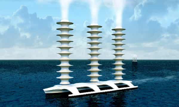
A conceptual Flettner ship, which would spray seawater into the air to make clouds reflect more sunlight.Illustration: J MacNeill
Like many geoengineering ideas, a potential preventive measure that could cool Arctic waters, and thereby help to keep the methane sealed in the ice comes mired in fear and politics.
“Marine cloud-brightening” is spraying a fine mist of seawater into clouds so that the salt makes them brighter, and more reflective of the sun’s heat.
It is already
being trialled as part of an Australian government-funded research programme to limit damage to the Great Barrier Reef, and Wadhams believes it could be used on a mass scale.
However, he thinks the most urgent need is to deploy it “on a more restricted scale, around the edges of the Arctic” where the methane escape risks are highest.
Vessels with tall masts would spray the seawater, in a system being developed by Stephen Salter, emeritus professor of engineering design at Edinburgh University.
Wadhams says it’s “the one major method of reducing global warming and saving us from methane attack … But there’s a lack of understanding of it, lack of vision and of course, lack of money.
It will cost a few tens of millions to get this thing going.”
Advertisement
With Britain hosting Cop26 in November, he says: “We can’t look inert.
The easiest thing to latch on to would be marine cloud-brightening.
It would work and achieve a great deal.”
The easiest thing to latch on to would be marine cloud-brightening.
It would work and achieve a great dealPeter Wadhams, Cambridge University
But even as Wadhams believes the process will be harmless, Ray Pierrehumbert, professor of physics at Oxford University, sees red flags.
“A lot of weather patterns like monsoons depend on the difference in heating between the continents and the oceans,” he says.
“If you do something to cool down the North Atlantic, let’s say to preserve the sea ice or Greenland glaciers, that shifts precipitation in the tropics.
Every part of the atmosphere is connected, so if you don’t balance your warming and cooling very carefully, then you get all sorts of changes in the climate system, some of which are difficult to predict.”
A graver risk, he says, is viewing technology such as this as a way to avoid reducing emissions.
“Once you emit CO2, its warming effect will continue for thousands of years.
Whereas marine cloud-brightening relies on particles that fall out of the atmosphere after, maybe, seven days.
So you have to renew them every week.
And if you come to rely on it for something like keeping the Great Barrier Reef from dying, you have to continue doing it for ever.
But all sorts of things could happen to force you to stop – wars, whatever – and if you do stop, then you get this extremely rapid, catastrophic warming.”
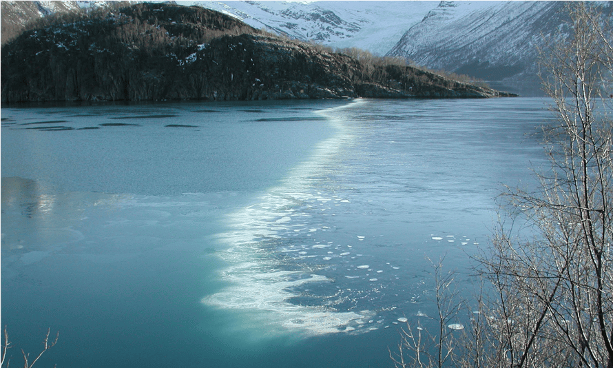
A bubble curtain of compressed air released to prevent Norway’s Holandsfjord freezing over.
Olav Hollingsaeter is looking at whether the concept can be used as a ‘hurricane slayer’.
Photograph: Courtesy: OceanTherm
Attempts to hack the weather are controversial.
A
method of solar radiation management, supported by Bill Gates, which would involve sending particles into the stratosphere to reflect sunlight, was described as
a billionaire trying to blot out the sun.
And cloud-seeding rarely appears without the accompanying phrase “playing god”.
But that isn’t deterring the people behind another new ocean geoengineering project to tackle hurricanes by cooling the surface water where they form.
In 2017, with his brother Bjorn, Olav Hollingsaeter, a former Norwegian navy submariner, started OceanTherm to repurpose established technology to reduce storm intensity.
During Norwegian winters, OceanTherm uses “bubble curtains” to release compressed air into deep water.
These push warmer water to the surface, which stops harbours freezing over.
Deploying bubble curtains in warmer waters shoots colder deep water upwards, cooling the surface.
Hollingsaeter is in talks with decision-makers in areas affected by hurricanes around the Gulf of Mexico, but his quest is complicated by legal and ethical concerns.
A similar “hurricane slayer” project by Alan Blumberg, the oceanographer behind an attempt to cool surface water by pumping colder water up,
told the Washington Post in 2019 that his research stalled over fears it might change the landfall of a storm, or increase its flooding impact.
Hollingsaeter claims his design improves on Blumberg’s .
“When you’re pumping colder water to the surface, the cold water is much heavier and will sink.
But the bubble curtain mixes the water temperatures all the way up, so there’s a thick layer of cooler water.”
He admits that nobody knows if cooling surface water could change a storm’s trajectory or power but argues that the potential benefits make it worth further research.
Rewilding coastlines is perhaps an easier climate crisis mitigation plan to get behind.
There are three types of “blue carbon” coastal ecosystems that store carbon in sediment or soil: mangroves, salt marshes and seagrasses.
Together, they absorb more carbon than land forests, and the carbon escapes only if the ecosystems are destroyed.
Unfortunately, this is what has happened to half of the world’s mangroves and many salt marshes, as coastlines are cleared of natural landscapes.
In the UK alone, more than 90% of seagrass meadows have been lost to coastal development, anchor damage and algae-feeding pollution.
It’s a very careful, robust, rigorous scientific processTom Green, Project Vesta
There are efforts to restore these habitats, as well as to encourage the growth of kelp, which absorbs an estimated 600m tonnes of CO2 a year globally.
Restoration is a local issue: in the UK,
Project Seagrass is laying rope and seed to create new sea meadows and the
Wallasea Island Wild Coast initiativein Essex is building up salt marshes using clay, chalk and gravel dug out by the Crossrail tunnelling in London.
In Kenya, where mangrove wood is used for charcoal, shipbuilding and carpentry, conservation organisations are working together on
long-term mangrove restoration projects.
Advertisement
Yet Gattuso believes that, while blue-carbon ecosystems need to be conserved and restored anyway, their potential effects on climate is limited.
Meanwhile, the other ocean-based measures that do not involve rewilding “are either at concept stage or risky”, he says.
“I wish that countries would put less emphasis on these approaches and return to the well-known, safe and most effective approach, which is to decrease sources of greenhouse gases,” he adds.
“This is where the urgency is.”
 Sunlight streaming through a kelp forest off California’s Anacapa Island.
Globally, kelp forests absorb some 600m tonnes of CO2 a year.
Photograph: Douglas Klug/GettyGreen knows Project Vesta is going to face a lot of similar objections.
He is aware that it is not just politicians and environmentalists who need convincing, but communities living along the coasts where he wants to dump the rock.
They must be engaged with “to explain what we’re doing, address any concerns and involve them in the decision-making process”, he says, claiming his plan is to start small, test, monitor and build up only if satisfied – and only then in stages.
“It’s a very careful, robust, rigorous scientific process.”
The benefits, he argues, could be huge.
Weathering could potentially be a cheap method of carbon removal and he claims CO2 removal gains would be 20 times more than emitted in the olivine’s mining and transport.
Furthermore, unlike land-based carbon-capture ideas, weathering locks carbon away irreversibly, rather than in underground reservoirs that risk leakage.
The bonus effect, he says, is that weathering renders the carbon “like baking soda, which de-acidifies the ocean”.
Project Vesta started with funds from philanthropy and grants, but Green expects the sale of carbon credits can pay for scaling up.
“Most countries will be unable to meet their nationally determined contributions (NDCs) to emissions reductions, and will need to offset them with carbon credits,” says Green.
Critics fear that rather being the way to achieve net-zero carbon, it will be a licence to keep burning fuel.
“Sometimes people say to me, ‘doesn’t this create a moral hazard?’” says Green.
“‘Will that not remove the incentive for people to cut emissions?’ And the answer is very clear: we need both.”
He believes that, ultimately, the carbon market will “sort it out.
If companies have to be net zero, and emissions of carbon are priced into everything, a company can decide whether it’s more efficient to, say, retool my fleet to be electric, or keep my gas-powered fleet and pay for negative emissions credits.”
Wadhams feels similarly pragmatic about the moral niceties of ocean geoengineering to save the climate.
“The main word to use in relation to methane escaping from the Arctic is: ‘Help!’” he says.
For him, the overarching sense is that we are reaching the denouement of the action movie, and only have the final act left in which to save the planet.
“This is all very hard,” says UCLA’s Sant.
“But action is the need of the hour.”
Links :

:focal(731x327:732x328)/https://public-media.si-cdn.com/filer/ff/dd/ffdd82b4-d793-4dbd-9b07-6cd16fb6c873/gebco2020-unmapped_web.jpg)


 Photograph: The Natural History Museum/Science Source
 Photograph: Marc Herbin/MNHN
 Photograph: Marc Herbin/MNHN
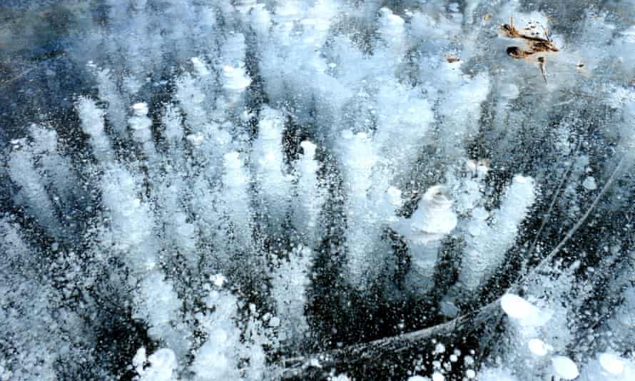