Astrolabe, an ancient navigation instrument that combined celestial maps, terrestrial maps and measuring devices.
A Muslim device from the 11th century
(Photo: WH_Pics, Shutterstock)
From YnetNews by Ettay Nevo/Davidson Institute of Science EducationFrom ancient Polynesian seafarers to nuclear submarines, from traders in camel caravans to astronauts - everyone must successfully navigate from one place to anotherWhen the Israelites left
Egypt on their way to the land of Canaan, divine providence, according to the biblical account, provided for their every need.
Food from the heavens, water from the rocks, medical services, a social and communal framework, and no less important—a navigation system: a pillar of fire to lead them by night and a pillar of cloud by day.
While the story of the Exodus likely did not unfold as described in the biblical sources, it holds an enduring place in cultural memory as a powerful mythological journey.
But what would the Israelites have done without the pillar of cloud and the pillar of fire? How would they have found their way to Canaan—a land they had never seen? Throughout history, individuals and entire populations have migrated and traveled vast distances, sometimes along familiar routes and other times into completely unfamiliar territory.
To deal with these challenges humanity gradually developed the discipline of navigation, the body of knowledge that allows us to orient ourselves, understand our surroundings, and find our way to new destinations, even in unfamiliar terrain.
We're on the map
With all due respect to the Israelites, navigating on land is relatively straightforward.
The terrain offers countless landmarks: towering mountains, winding rivers, distinct land formations, recognizable structures, and even regional vegetation and wildlife typical to specific regions.
To find your way, all you need is a map that marks the location of these landmarks —whether through detailed illustrations or agreed-upon symbols.
And indeed, already at early stages of human civilization, people began mapping their surroundings.
Exactly how early this began is still debated.
Many researchers point to a mural uncovered at the Çatalhöyük site in Turkey to be the oldest known map.
The mural, likely from the 7th millennium B.C.,is thought to be a diagram of village houses though not everyone agrees that it qualifies as a true map.
Similar debates exist over even older artifacts, such as 10,000- and even 20,000-year-old mammoth tusks with etched patterns that may be a symbolic representation of the geographic environment, a 16,000-year-old rock from Spain that appears to show hunting grounds, and other ancient finds.
Some of the ancient maps we are familiar with were used for navigation alone: maps from Babylon and ancient Egypt, for example, were used to delineate borders between farmers' plots and to calculate their size for taxation purposes.
Still, when it comes to orientation and movement through unfamiliar terrain, a map remains an essential tool.
For example, if we wanted to walk from
Athens to Sparta, we’d start by heading northwest out of Athens.
After about 25 kilometers, we’d reach Eleusis, where we’d turn west-southwest and continue another 50 kilometers along the coast to Isthmia.
From there, we’d go roughly 100 kilometers southwest to Tripoli, and then another 50 kilometers south to reach the gates of Sparta.
Without a map, such planning—and the journey itself—would be extremely difficult.
But even with a map, navigation requires more.
We must know our current position, the direction we're heading, and the distance traveled—or at least our walking speed to estimate it.
Without such information, we risk losing our way unless we rely on marked roads, signs, or the kindness of shepherds.
In modern Greece, we might be fortunate enough to find all of these.
But in ancient times and distant lands, such help was far from guaranteed.
A computer scan of a Babylonian stone plate from the 7th century B.C., engraved with a map of mesopotamia
(Photo: SHEILA TERRY / SCIENCE PHOTO LIBRARY)
The most obvious natural landmark available to us is the sun.
Even in the earliest days of human history, people observed that the sun rises each morning from roughly the same direction—what we now call east—and sets in the opposite direction, west.
However, determining direction during the hours between sunrise and sunset is more complicated.
Throughout the day, the sun appears to move across the sky—not in a straight line, but along a curved path.
In the northern hemisphere, this path leans toward the south; in the southern hemisphere, it leans northward.
The exact trajectory of the sun depends on both the observer’s location on Earth and the time of year.
To accurately use the sun for navigation, it’s important to know roughly where you are, what season it is, and, ideally, the time of day.
At night, you can locate north with relative ease using the North Star, which appears to us to be located almost directly above Earth’s North Pole - assuming clear skies and, naturally, and as long as we are located in the northern hemisphere.
You can also use other stars or prominent constellations to navigate, but their positions shift throughout the night and change with the seasons as well as with the observer’s location.
Here too, knowing your approximate position and the time is crucial for accurate orientation.
It’s no wonder therefore that throughout history the fields of cartography and navigation have been closely tied to the development of timekeeping technologies.
Diagram showing the location of the Polaris (the North Star) relative to the constellations Ursa Major and Ursa Minor
(Photo: Mykola Mazuryk, Shutterstock)
Navigating the waves
As mentioned earlier, land navigation benefits from terrain features, visible landmarks, roads, trails and signs.
At sea, however, such aids vanish.
When surrounded by nothing but water from horizon to horizon, maintaining direction becomes a formidable challenge—especially when the weather is unfriendly.
Nevertheless, sea travel could often be faster and more efficient than land travel, particularly across mountainous regions or when transporting large quantities of goods.
And, of course, for island dwellers, maritime navigation had no alternatives and was essential for trade—or for waging war—with other islands or with distant continents.
Ancient Greek societies, such as the Minoans and Mycenaeans, were among the first to develop shipbuilding along with navigational techniques.
Much of their early navigation was coastal: ships sailed within sight of land, and sailors with sharp eyesight learned to recognize prominent coastal features to orient themselves.
Over time, methods of navigation by the sun and stars also gradually emerged.
It’s no coincidence that the word "navigation" in English—and its equivalents in many other languages—derives from the ancient Proto-Indo-European word nauta, meaning ship or boat.
Originally, the term referred not just to the act of navigation but to the act of sailing itself—and it is still sometimes used that way in modern English.
In another part of the world, Polynesian navigators in the Pacific Ocean developed astonishingly sophisticated methods for crossing vast expanses of open water between islands and archipelagos.
Centuries before the Common Era, Polynesians passed down from generation to generation extensive knowledge regarding the characteristics of the sea in different regions, based on features such as winds, wave patterns, and currents with extraordinary skill.
This knowledge was often represented in unique navigational maps, known as stick charts, crafted from thin and flexible sticks, and marked with shells or coral fragments to represent islands.
These maps, combined with the extraordinary skills of the navigators, enabled Polynesians to travel between islands separated by hundreds—or even thousands—of kilometers.
Polynesians, Greeks, and many other seafaring cultures also learned to use animals as navigational aids.
Observing the behavior of certain fish or seabirds helped indicate proximity to land.
Some sailors even carried birds aboard: when released at sea, a bird that circled and returned signaled open water, meaning they could sail on, while a bird that flew in a straight line likely indicated nearby land, and following it was likely to lead to a place to land.
This method likely influenced the biblical account of Noah’s Ark and the release of the dove.
Stick chart from the indigenous peoples of the Marshall Islands
(Photo: LIBRARY OF CONGRESS, GEOGRAPHY AND MAP DIVISION / SCIENCE PHOTO LIBRARY)
Crossing the lines
The Greek astronomer Ptolemy (Claudius Ptolemaeus), who lived and worked in Alexandria in the second century CE, is often regarded as one of the greatest astronomers of antiquity—though he shares that title with several others.
Like many scholars of his time, Ptolemy did not limit himself to a single discipline, and perhaps it is fortunate that he didn’t.
His astronomical work included the detailed and systematic mapping of constellations, alongside an inaccurate model of the solar system in which the sun and planets revolved around the Earth, as well as studies in astrology.
At the same time, Ptolemy produced one of the most remarkable geographical works of antiquity, compiling a book that contained numerous maps, including a map of the entire known world.
By Ptolemy’s era, scholars already understood that the Earth was spherical.
One of Ptolemy’s key contributions was the introduction of a global coordinate grid, dividing the sphere into lines of latitude—parallel to one another—and lines of longitude, which converge at the poles.
In fact, this innovation likely originated with Hipparchus, an astronomer who lived about three centuries earlier—and who (surprise!) is also often hailed as the greatest astronomer of antiquity.
However, it was Ptolemy who fully applied the system and incorporated grid-marked maps into his major work, Geography (or Geographia).
Although the original manuscript was lost, parts of it were reconstructed from surviving copies, along with a map depicting the known world at the time.
One of Ptolemy’s notable errors was his underestimation of Earth's size.
Nevertheless, two key principles from his maps have endured: the recognition that maps must be adjusted when projecting a spherical surface onto a flat plane, and the use of latitude and longitude lines to describe locations with precision.
An early global worldview, featuring the use of latitude and longitude grids.
Reconstruction of Ptolemy’s world map
(Photo: Morphart Creation, Shutterstock)
Using such a grid, the location of any point on Earth can be described with two numbers: the distance north or south from the equator (latitude) and the distance east or west from a reference line of longitude, defined as zero.
The greater the precision of these numbers, the smaller and more specific the area they define.
For example, at the intersection of latitude 37 degrees, 59 minutes, and 3 seconds north (37°59′03″N) and longitude 23 degrees, 43 minutes, and 41 seconds east (23°43′41″E) lies the city of Athens, the capital of Greece.
Alongside the concept of latitude lines, navigational tools were developed that allowed sailors to calculate their position using celestial bodies.
The simplest of these was an adjustable protractor, which could be aimed at a specific celestial object to measure its position relative to the horizon.
For instance, if the angle to the North Star measured 30°, it indicated a position 30 degrees north of the equator—at latitude 30°N.
Sailors could then travel north or south to reach the desired latitude, and from there, sail east or west toward their destination.
Before long, the basic protractor quickly gave way to the Astrolabe (Greek for “star-taker”), an instrument combining an angle measurement tool with maps of the Earth and markings for lines of latitude.
Some astrolabes also featured celestial maps, engraved on wooden or metal disks that rotated relative to each other, allowing the user to observe and calculate their position based on several known constellations.
The basic astrolabe was likely invented in the 2nd century BCE—some even attribute its invention to Hipparchus—and it greatly improved navigation ability, both on land and at sea, provided that conditions allowed for accurate measurements.
More advanced models even allowed users to estimate the time of day based on the positions of celestial objects.
Using such devices at known locations also helped astronomers chart the skies more precisely, advancing both navigation and the science of astronomy.
A grid system enabling the definition of any point on Earth through numerical coordinates .
Longitude (right) and latitude lines
(Photo: Anshuman Rath, Shutterstock)
Finding north
More than 2,500 years ago, people in ancient Greece, China, and likely other parts of the world were aware of the existence of magnetic stones that could attract iron.
Such stones were used in rituals, games, fortune-telling, and other practices.
The word "magnetic" likely derives from the Greek city of Magnesia, in present-day Turkey, where many such stones were found.
It would take more than a thousand additional years before the Chinese discovered that these stones could be used for navigation.
They observed that a thin, lightweight piece of iron, magnetized by rubbing it against a magnetic stone and light enough to float on the surface of water, would rotate and align itself toward magnetic north.
Over time, these devices were gradually refined into the compasses we know today, reaching Europe by the 12th century.
Small improvements were introduced, such as scale markings that allowed for more accurate determination of angles towards specific objects or directions of travel, and mechanisms that stabilized the needle, allowing it to rotate with greater precision.
Yet the basic principle remained unchanged: the compass points toward Earth's magnetic north, enabling navigators on land or at sea to quickly and easily determine the different directions.
Of course, the magnetic compass is not free from inaccuracies.
Earth's magnetic pole is not exactly aligned with its geographic pole, and compasses become less reliable near the poles.
Local magnetic fields, whether natural (from magnetic rocks) or artificial (from the iron hulls of ships or electronic systems), can also interfere with readings.
Still, in most situations, the magnetic compass proved incredibly reliable and revolutionized navigation.
It allowed travel in any weather, at any time.
Once a navigator knew their position on a map, all that remained was to set the ship’s course using the compass—and sail toward the destination.
Though not without inaccuracies, the simple compass revolutionized navigation
(Photo: Paya Mona, Shutterstock)
Navigating with your eyes closed
The invention of the compass paved the way for a navigation technique known as dead reckoning, also referred to as approximate navigation or computed navigation.
Imagine needing to sail to a point 2,000 kilometers to the southwest.
By setting your ship’s heading in that direction and knowing, for example, that you are traveling at a speed of 20 kilometers per hour, you could, in theory, reach your destination after 100 hours of steady sailing.
However, this method carries significant risks, especially if your equipment is unreliable or if winds and currents subtly push you off course.
It also depends heavily on accurately knowing your speed—something that seems simple today but was anything but easy in ancient times.
Early sailors could only estimate their speed based on the strength of the wind, the feel of ocean currents, or by timing the duration of travel between known landmarks.
Measuring time at sea presented its own challenges, often relying on celestial observations or basic instruments to track short time intervals.
One common method for estimating speed involved tossing a weighted rod tied to a coiled rope into the water.
Knots were tied at regular intervals along the rope.
As the ship moved, a sailor would let the rope play out and use an hourglass to measure a fixed short interval—say, half a minute—counting how many knots passed through his hands.
The faster the ship, the more knots would pass in the set time.
Thus, the "knot" became a unit of speed.
It would take centuries before a standardized definition was established, long after the days of ropes, knots, and hourglasses had faded.
Today, one knot is defined as one nautical mile—1,852 meters—per hour.
The term is still widely used in shipping, aviation, and meteorology.
When the skipper reports a 20-knot wind, he is referring to a wind speed of about 37 kilometers per hour.
The ability to estimate speed at sea greatly enhanced navigation, even without relying solely on dead reckoning.
It enabled sailors to better estimate distances and cartographers to produce more accurate maps.
It also illustrated the tight link between navigation and timekeeping.
A British pilot’s navigation kit from World War II, featuring a magnetic compass and a watch
(Photo: J.S.Bond, Wikipedia)
Refining accuracy
Over time, increasingly accurate maps were supplemented by detailed data tables.
These tables were the result of the meticulous work of astronomers who recorded and calculated the positions of celestial objects at different locations around the world.
For example, by measuring the angle between the sun and the horizon at noon, one could determine latitude with great precision—provided the date was known (or conversely, determine the date if the location was known)—using tables that listed these angles for every place and time.
Other stars could also be used similarly for navigation.
One astronomer who contributed important tables at a crucial historical moment was Abraham Zacuto, who worked in Spain and Portugal during the late 15th and early 16th centuries.
His works were published during the great age of exploration and played a vital role in assisting sailors like Christopher Columbus, Vasco da Gama, and others in their voyages to discover America, circumnavigate Africa, and reach new lands.
From the 18th century onward, such tables were regularly compiled into almanacs, which became essential navigation aids.
An almanac is a type of annual data book, and navigational almanacs contained tables listing the precise positions of dozens of stars and planets for every day and hour of the year.
In 1767, Britain’s Royal Observatory at Greenwich began publishing its Nautical Almanac annually.
While other institutions would later publish their own almanacs, Greenwich soon became the global reference point for navigation.
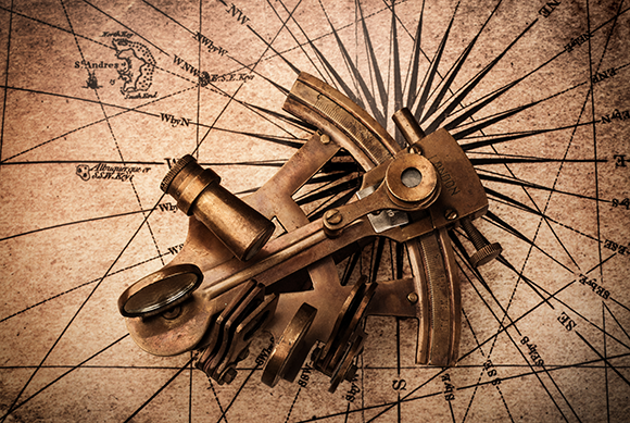
At the same time, the accuracy of celestial measurements improved dramatically with the invention of a new device - the Sextant.
Similar in purpose to the astrolabe, the sextant measured the angle between celestial bodies, but it did so with far greater precision, aided by optical lenses.
These advancements greatly enhanced maritime navigation, yet one major challenge in determining human position on Earth still remained.
Sextant placed on a map
(Photo: Triff, Shutterstock)
The longitude lines
In October 1707, a fleet of 21 British Royal Navy ships was making its way home from the war against Spain.
Several days of severe weather made it extremely difficult for the navigators to determine the ships’ positions, and on October 22, many of them ran aground on the rocks of the Isles of Scilly, southwest of Cornwall, England.
Without the ability to perform accurate position measurements after days of stormy sailing, the navigators had to rely on rough estimates of the distance traveled.
They believed they were about 300 kilometers farther southwest than their actual location, safely away from dangerous reefs.
This miscalculation led to one of the worst naval disasters in British history: four ships sank, several others were severely damaged, and at least 1,400 sailors lost their lives.
Although the disaster resulted from a combination of errors and misjudgments, the British Parliament chose to focus on one critical issue, offering a large reward to anyone who could solve the pressing navigational challenge of accurately determining a ship’s longitude.
As mentioned earlier, it is relatively easy to determine one’s position north or south of the equator by measuring the angles of stars at night and the sun at noon.
However, determining position along the east-west axis is much more challenging.
The obvious solution lies in timekeeping: if you knew the exact time at your current location and the exact time at a specific reference point with a known position, you could calculate your distance east or west based on the time difference.
Using observations of the sun, stars, and almanac tables, it was possible to determine local time aboard a ship, but knowing the exact time at the reference point was a much greater challenge.
In theory, a clock could be brought on board—but the mechanical clocks of the period were not accurate enough for long voyages, given the swaying and turbulence of sea travel.
Pendulum clocks, which performed reliably on land, failed at sea because they required stability to operate properly—something impossible aboard a moving ship.
Mid-18th-century engraving of the shipwreck at the Isles of Scilly, featuring the ship Association at the center
(Photo: Wikipedia)
Enter John Harrison, an English carpenter and watchmaker, who dedicated much of his life to solving this problem.
Harrison developed the marine chronometer—a clock capable of maintaining precise time despite the harsh conditions at sea.
His first models were large and heavy, but following over 13 years of relentless work, he completed his fourth version at the age of 68: a compact, portable chronometer that proved its accuracy during a transatlantic crossing.
Harrison’s invention effectively solved the longitude problem.
With such a clock on board, showing the time at a known reference point, navigators needed only to determine the local time at their current location, compare it to the clock, and calculate their distance from the reference point.
Accurate latitude measurements remained important as well, since the Earth's circumference varies with latitude.
Since Greenwich had already been established as the astronomical reference point, it also became fixed as the reference for longitude calculations, and the line running from pole to pole through Greenwich was designated as the Prime Meridian (longitude 0°).
For many years, "Greenwich Mean Time" (GMT) also served as the global standard for setting local clocks, and remains familiar today, although for scientific and technical purposes it has largely been replaced by Coordinated Universal Time (UTC).
During the time when Harisson was developing the marine chronometer, another method for determining longitude was developed: lunar distance measurementsPDF file, This involved measuring the height of the moon in the sky at a specific time and comparing it to Greenwich’s data using almanacs.
When weather conditions permitted these observations, it was possible to calculate longitude with reasonably good accuracy.
However, the method required much longer and more complex calculations than simply using a clock.
Once the price of chronometers dropped to a more affordable level, determining longitude with their help quickly displaced earlier methods, once again highlighting the close relationship between navigation and timekeeping.
The fifth model of John Harrison’s marine chronometer, small enough to fit in a pocket
(Photo: Racklever, Wikipedia)
Looking from above
In 1886 German physicist Heinrich Hertz succeeded in transmitting a spark between two electrical wires that were not physically connected.
Next, he increased the distance between the wires to several meters and demonstrated that the invisible radiation traveling between them moved at the speed of light.
These experiments marked the first successful transmission of electromagnetic radiation.
Scientists who followed Hertz quickly recognized the potential of his discovery.
Within just two decades, radio waves were being transmitted across the Atlantic Ocean, connecting America and Europe—a distance of thousands of kilometers.
This young technology held immense promise not only for communication but also for navigation.
For example, a marine vessel could orient itself toward a radio signal it received from a distance, and navigate more easily—even in stormy weather, when location measurements using traditional methods were impossible.
Using relatively simple mathematics and the method of triangulation, it is possible to calculate the distance between a receiver or transmitter and two antennas at known locations, as well as the angle between the receiver and the antennas.
A more advanced method, trilateration, allowed for the determination of an exact position by measuring distances from three points—made even more precise by using additional points, a technique known as multilateration.
Radio not only revolutionized maritime navigation but also had a profound impact on the emerging field of aerial navigation at the beginning of the twentieth century.
Although humans had ascended into the skies as early as the 18th century, it was in balloons that could not truly be steered.
The advent of motorized flight brought new challenges and an urgent need for reliable navigation systems for airships and, later, airplanes.
In a relatively short time, advances in both aviation and electronics made it possible to equip every aircraft with a radio transmitter and receiver.
Radio signals greatly aided—and continue to aid—aircraft and other vehicles in navigating their routes.
However, radio navigation has its limitations: it depends on ground stations to transmit the necessary signals, and such stations are not always available.
Over enemy territory, signals might be disrupted or deliberately falsified, and there is always the risk of equipment malfunction.
For these reasons, despite its importance, pilots cannot rely solely on radio for navigation.
Array of antennas and beacons at Düsseldorf Airport, Germany
(Photo: Rene Hausotte, Shutterstock)
Inventing the wheel
The name of the French physicist Léon Foucault is best known today thanks to the pendulum named after him, which dramatically demonstrated the Earth's rotation.
Foucault performed his famous demonstration in 1851, but continued searching for methods to measure Earth's movement and its variations.
This pursuit led him to develop the gyroscope—a device consisting of a spinning disk mounted to rotate freely on its axis, with minimal friction.
As long as the disk spins, the conservation of angular momentum causes the gyroscope to resist changes to its axis of rotation, exerting a force perpendicular to the direction of any attempted change.
In Foucault’s time, however, there were no means to keep the disk spinning indefinitely.
Still, his successors quickly recognized the gyroscope’s immense potential, for example in stabilizing ships and, later, airplanes, and also for use as a compass.
If a gyroscope’s axis is aligned to point north, it will continue to point that way as long as the disk spins.
If a ship or aircraft veers off course, the gyroscope detects the deviation.
Unlike a magnetic compass, the gyroscope is unaffected by local magnetic fields, nearby devices, or proximity to the poles, and it does not require a perfectly level surface to function.
For example, when an aircraft makes a sharp turn and tilts, the magnetic compass becomes unreliable, while a gyroscope not only remains accurate—it can also indicate to the pilot the precise angle of the plane’s turn.
Gyroscope
(Photo: Tatiana Shepeleva, Shutterstock)
Developing efficient gyroscopes for aviation was a major challenge—but one that paid off.
Since a gyroscope can both indicate direction and help maintain it by stabilizing an aircraft, it became the foundation for the development of automatic flight control systems (AFCS).
American pilot Lawrence Sperry developed one of the first autopilot systems, building on knowledge from his father Elmer Sperry, one of the inventors of the gyroscopic compass.
In June 1914, during a flight safety innovation contest in France, Sperry demonstrated his stabilization system with a dramatic stunt.
During the first pass over the judges' stand, he raised both hands in the air to show he wasn’t piloting the plane—the aircraft maintained its course and stability on its own.
On a second pass, his flight mechanic Emil Cachin crawled out onto a wing, dramatically shifting the plane’s weight, while Sperry continued waving, demonstrating that the plane remained stable despite the drastic weight shifts.
Over time, gyroscopes became an integral part of every flight system, and instruments such as the artificial horizon, which displays an aircraft’s roll (side tilt) and pitch (nose up or down) to the pilot, are also based on them.
An important addition to gyroscopes was the accelerometer, which enables the measurement of changes in a device’s speed at any given moment.
With the stabilizing effect of gyroscopes, these systems can measure acceleration along each of an aircraft’s three axes of movement and provide critical information about changes in position.
A system based on gyroscopes and accelerometers can be used for accurate computational navigation.
If we provide the system with the precise coordinates of our starting location and our initial velocity, we can accurately and continually calculate changes in speed and direction, and thus our precise location, without relying on radio signals or any other external information.
Today, this method is known as Inertial Navigation.
It is critical not only for aircraft and ships but also for submarines, which may remain submerged for weeks without any contact with the outside world.
Inertial navigation is also employed by unmanned aerial vehicles (UAVs), and by weapons systems such as cruise missiles and ballistic missiles, allowing them to travel long distances and strike distant targets with high precision without depending on external data sources that could be disrupted by defense systems.
Over the years mechanical gyroscopes were replaced with gyroscopic systems that are based on measurements of the degree of change in the rotation of laser beams.
These laser-based gyroscopes offer high accuracy and, most importantly, are remarkably small.
Today, such gyroscopes, combined with accelerometers, are installed in virtually every smartphone.
They enable the device to rotate the display according to its orientation, stabilize the camera to produce sharp images even when the phone is unsteady.
They also enable accurate measurement of the movement, angle and speed of the phone, supporting the development of a wide range of applications.
For example, some apps can automatically alert emergency services if the device detects a sudden drop in speed, indicating that the user may have been involved in a car accident and is unable to call for help.
The inertial navigation system of the Apollo spacecraft
(Photo: ArnoldReinhold, Wikipedia)
Observing from higher above
On October 4, 1957, the Soviet Union launched the first artificial satellite.
Sputnik became the first human-made object to orbit the Earth, carrying only a simple radio transmitter that broadcast a constant signal.
Scientists and radio enthusiasts around the world followed the satellite in space using these signals, but a few American scientists quickly realized it could work the other way around: if the satellite’s exact course was known, the timing and characteristics of its signal could be used to determine our own location.
Within a few years, the United States developed the Transit system, primarily intended to provide precise positioning for submarines armed with nuclear-tipped ballistic missiles.
Inertial navigation systems—especially those of the time, tended to accumulate small errors over time.
To improve the likelihood that a missile launched from a submerged submarine would accurately reach its target, it was essential to update the submarine’s launch coordinates as precisely as possible.
The Transit system, initially consisting of four satellites, was designed to allow a submarine to receive a signal within a relatively short time, update its position, launch its missile, and then quickly submerge again to avoid detection.
Later, the Transit system was replaced by newer systems featuring a larger number of satellites.
Over time, the United States opened its military positioning system—GPS, short for Global Positioning System—for civilian use, and today it is available to anyone, alongside several equivalent systems developed by other countries.
The positioning system relies on the fact that, at any given moment, every point on Earth is within direct line of sight of several satellites.
Each satellite continuously transmits a precise time signal toward Earth.
A receiver that picks up these signals can compare the time of transmission with the time of reception to calculate the distance the signal has traveled.
By cross-referencing signals from multiple satellites with known positions, the receiver can accurately determine its own location.
To achieve this, the time signals must be extremely precise and perfectly synchronized between the satellites and the receivers, which is why the satellites are equipped with atomic clocks capable of measuring time with exceptional accuracy.
It is yet another clear reminder of the enduring connection between navigation and timekeeping, even in the 21st century.
With the advancement of electronics, receivers have been miniaturized to the point where nearly every smartphone now contains a chip capable of determining its location with an accuracy of just a few meters—or even less.
By cross-referencing this information with mapping applications, our phones can tell us not just our geographic coordinates, but the exact street, building, or even the best route to our next destination—whether on foot, by private car, or via public transport, anywhere on Earth.
Today, nearly everyone carries a smartphone equipped with a chip that receives time signals from navigation satellites and determines location with meter-level accuracy.
(Photo: Bakhtiar Zein, Shutterstock)
Seeing stars
Thanks to modern technology and satellites, we can easily determine our location anywhere on Earth—even while flying high above it or orbiting it in a spacecraft.
But what happens when we venture farther away from Earth? How do we navigate in the vastness of deep space?
Navigation tools in space are, in principle, very similar to those used on Earth.
Every spacecraft is equipped with gyroscopes and accelerometers that measure its position and orientation along the three axes of motion.
Maintaining the correct orientation is especially critical when firing the engine to change course, as the engine must be pointed precisely in the intended direction.
Accurate orientation is also essential for tasks such as aiming antennas toward Earth, aligning solar panels towards the Sun, and more.
Astronaut Jim Lovell measuring star distances during the Apollo 8 navigation system operation
(Photo: NASA)
In space, dead reckoning (or computed navigation) can also be used—and often even more easily than on Earth.
Since a spacecraft’s speed remains nearly constant unless its engines are fired, if it is aimed correctly and given the appropriate velocity, it has a good chance of reaching its intended destination.
To ensure accuracy, spacecraft perform course corrections by checking their position in space.
But without GPS satellites, how is this possible? By using the stars.
Before a mission begins, a set of bright, easily identifiable stars is selected.
By measuring the precise angles to these stars, the spacecraft can calculate its position relative to them.
During the Apollo missions, astronauts carried out these measurements manually using a telescope.
Today, however, many spacecraft are equipped with star trackers—advanced computerized cameras that scan the sky, measure the angles to predetermined stars, and automatically compute the spacecraft’s position relative to its planned trajectory.
Thus, thousands of years after ancient nomads and sailors looked to the night skies to guide their journeys, humanity still navigates by starlight—only now with advanced technology, setting course for destinations our ancestors could scarcely imagine.
Links :