A mysterious formation lurking deep in the ocean has been spotted just a few miles off the coast of Southern California
From DailyMail by Stacy Liberatore A mysterious formation lurking deep in the ocean has been spotted just a few miles off the coast of Southern
California.
Geographically known as Sycamore Knoll, the natural underwater structure looks like a bump pushing
up from the ocean floor, with a flat, table-like top.
It has been studied by scientists for years, though recent claims by conspiracy theorists have suggested Sycamore Knoll might be an underwater '
alien base.'
A
Reddit post from earlier this year featured a
Google Earth image of Sycamore Knoll with the title: 'Underwater
UFO base between Malibu and Catalina Island.'
'Some refer to it as an anomaly while others believe it is an alien base,' a Redditor shared in another post this year.
'It's believed to be between two-and-a-half and three miles wide.'
Localization with the GeoGarage platform (NOAA raster chart)
Visualization of Sycamore Knoll in the NOAA ENC viewer (ENC US3CA69M)
zoom of the ENC over the blurry Google area
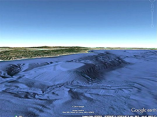
Sycamore Knoll sits about 2,000 feet below the surface and is located 6.6 miles off the coast of Malibu. It is located at geographic coordinates 34° 1'23.31″N 118° 59'45.64″W.
While Google Earth images from 2014 captured detailed views of the formation, it appears to have been wiped from the platform as of 2025, adding more mystery about its origins.
Sycamore Knoll sits about 2,000 feet below the surface and is located 6.6 miles off the coast of Malibu. It is located at geographic coordinates 34° 1'23.31″N 118° 59'45.64″W
The formation, however, can be seen on other online mapping platforms such as a fishing charter app.
Sycamore Knoll has been known for the past several decades but gained widespread public attention in 2014 when Google Earth images led to speculation about its structure, with some suggesting it resembled an artificial or alien base.
The structure was also featured on the 'Fade to Black' podcast with Host Jimmy Church, who fed into conspiracies proclaiming it as not natural, but rather extraterrestrial.
He speculated that it could be the biggest center of UFO activity found since Roswell, New Mexico, the Los Angeles Almanac reported.
The National UFO Reporting Center has also received many reports of mysterious objects flying over the exact area as Sycamore Knoll, with some people saying they spotted craft emerging from the ocean.
'It looked like a massive, cathedral-shaped structure — multiple pointed edges all glowing brilliantly white, heading straight into the ocean,' one California resident reported to the UFO reporting site after seeing a mysterious craft in the sky.
'There was no splash, no sound... just a flash, and it was gone.
'It happened so fast — like a giant ship or object vanishing beneath the surface in an instant.'
The X account Daily UFO, which has over 35,000 followers, shared a post about Sycamore Knoll in January, noting how Google Earth previously showed the tabletop formation and now it is blurred.
The formation, however, can be seen on other online mapping platforms
such as a fishing charter app (pictured)
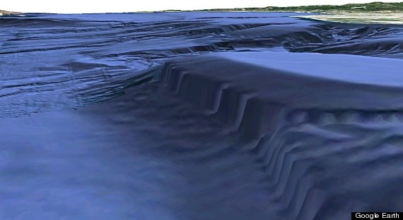
The natural underwater structure looks like a bump pushing up from the ocean floor,
with a flat, table-like top
The dark areas that people are saying look like the inside of the base really starts to look just like shading of indentations to the shelf, and the 'pillars' are now represented as jagged ridges.
(GE 2014)
Some have suggested that the Google Earth image 'isn't an actual picture, so there's nothing to blur,' noting that 'it's a digital markup of data.
The 'blur' is just a lack of data.'
Republican Congressman Tim Burchett also claimed in January that an admiral, whom he did not identify, told him about a UFO that was moving underwater at remarkable speed.
'They tell me something's moving at hundreds of miles an hour underwater... as large as a football field, underwater,' the Tennessee congressman told former Republican congressman Matt Gaetz, who now hosts a show on right-wing news outlet One America News.
'This was a documented case, and I have an admiral telling me this stuff.'
The renewed attention in Sycamore Knoll also comes days
after a UFO expert who released a new video this week showing the infamous Tic Tac revealed bombshell theories about the phenomenon.
Jeremy Corbell, an investigative journalist and filmmaker known for his work with George Knapp on military-documented unidentified anomalous phenomena (UAP), has once again ignited public debate over UFOs - this time with newly released footage captured aboard the USS Jackson in 2023.
The video, made public this month after a multi-year verification process, shows what Corbell and military witnesses described as a 'self-luminous, wingless, tailless' craft rising from the Pacific Ocean.
While Google Earth images from 2014 captured detailed views of the formation, it appears to have been wiped from the platform as of 2025, adding more mystery about its origins
Current view (satellite imagery 2023)
Google obtains their underwater data from several different sources, including satellite radar and echo sonar from the Navy, NOAA, NASA and other agencies. Because they often use very different technologies, the derived information isn't always going to agree. When it doesn't, Google relies on its automatic 3D auto-generation programs to make sense of it.
"We're dealing with limited information to render the graphic because we can see it evidenced in the disparity of image quality between the anomaly and the areas immediately surrounding it," former FBI spacial agent Ben Hansen (who has an extensive background investigating and analyzing questionable pictures and videos) added. "The blurry sections and jagged edges obviously suggest a patchwork of image processing has taken place."
But Corbell insisted the new footage is far from an isolated event.
Instead, he said it fits a broader and increasingly alarming pattern: repeated sightings of intelligently controlled craft that defy known aerodynamics, appear regularly in the same offshore military training zone, and may originate from below the ocean's surface.
According to Corbell, the 2023 incident echoes two other major military encounters: the 2004 Nimitz sighting and a lesser-known but well-documented 2019 event in which a swarm of UAPs surrounded ten Navy warships over multiple nights.
The new footage, he argued, is not a standalone revelation but part of a growing body of evidence pointing to intelligently controlled craft - capable of transmedium travel (moving seamlessly through space, air, and water) - that have repeatedly appeared over decades in the same region: Warning Area 291, off the coast of Southern California.
Jeremy Corbell, an investigative journalist and filmmaker known for his work with George Knapp on military-documented UAP, has once again ignited public debate over UFOs - this time with newly released footage captured aboard the USS Jackson in 2023
Newly released video taken on board the USS Omaha, a littoral combat ship, shows what has been described as a transmedium vehicle (that is, a vehicle capable of traveling through both air and water) moving, hovering, and disappearing into the Pacific Ocean.
The 2023 release was supported by a new military witness: an active-duty U.S. Navy combat information center (CIC) operator who claims to have seen the object rise from the ocean with his own eyes.
Corbell and Knapp, known for handling sensitive testimonies, vetted the witness and aligned his account with radar data and FLIR imagery.
The Navy veteran tracked the object using the ship's high-powered SAPPHIRE FLIR thermal targeting system.
Radar detected four unknown targets in the area, though two were captured on video.
According to the witness, all four UAPs performed an instantaneous, synchronized maneuver, shooting off simultaneously without visible propulsion, suggesting intelligent coordination.
Links :

 Simulations showing secondary gravity waves from the eruption.