StratoBus is a stationary stratospheric airship, offering autonomous operation and suited to multiple missions.
It measures 100 meters long with a maximum diameter of 33 meters (328 x 108 ft), and weighs less than 5 metric tons.
Designed to operate at an altitude of 20 kilometers (about 66,000 ft), above the jet stream and air traffic, StratoBus can carry a payload of up to 250 kg (550 lb), with 5 kilowatts of onboard power.
StratoBus doesn’t need a launch vehicle to reach “orbit”.
It takes just four hours to reach the stratosphere, and about the same to come back down.
Its operating economics make it a real “low-cost” product, extremely competitive for regional civil or military applications, including telecommunications, navigation, observation (especially surveillance), etc.
The program is led by Thales Alenia Space as prime contractor.
Over the years, scientists have attempted to visually communicate the
Earth’s warming in many ways. They’ve developed an array of maps,
charts, and animations that present an unmistakable picture of a warming
world.
But I’ve seen no visual as striking and effective as the infographic posted to Twitter Monday by climate scientist Ed Hawkins.
Hawkins illustrates the warming in a series of circles, each one
portraying a year in the historical climate record spanning 1850 and the
present.
As time passes and the planet warms, the circles expand
outward.
Together the circles are part of one unwinding spiral,
which serves as a fitting metaphor for the long-term course of the
Earth’s temperature.
Individually, the circles behave somewhat
erratically.
At times, especially early in the record, the circles
contract, conveying periods of cooling.
There are also periods when the
circles are packed close together, signifying little temperature
change.
But as time wears on, especially over the past few decades, you
see more outward leaps, when climate warming is speeding up.
Of
particular interest is the most recent burst coincident with the
temperature increase of 2016. It is clearly warmer than anything
preceding it by some distance and approaching 1.5 degrees Celsius above
the baseline average.
The graphic plainly illustrates how unusual this
year is in a long-term context, and it’s not difficult to see why
climate scientists believe it is nearly certain to be the warmest year on record.
Hawkins also created a more conventional chart, shown below, which is also extremely effective at showing how anomalous 2016 is.
But the motion of the spiral animation makes it stand out among
climate warming visualizations.
It unambiguously shows the planet’s
relentless march toward higher temperatures, but without losing the
interesting complexity seen in the year-to-year movements.
“The
animated spiral presents global temperature change in a visually
appealing and straightforward way,” Hawkins wrote on his blog, the Climate Lab Book.
“The pace of change is immediately obvious, especially over the past few decades.”
The animation uses global temperature data from the Hadley Centre of the United Kingdom’s Met Office.
Below are some other visuals which, in my view, also do a good job illustrating global warming:
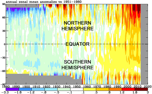
This visualization illustrates Earth’s long-term warming trend, showing temperature changes from 1880 to 2015 as a rolling five-year average.
Orange colors represent temperatures that are warmer than the 1951-80 baseline average, and blues represent temperatures cooler than the baseline.
Produced by NASA, the chart illustrates how temperatures have compared
to “normal” (or the 1951-1980 average) from 1880 to present, from pole
to pole (-90 latitude to 90 latitude).
NOAA’s powerful new supercomputers paved the way for another upgrade to
the U.S. Global Forecast System (GFS), NOAA’s primary model for weather
prediction.
Today’s upgrade builds on last year’s significant boost to the GFS, which more than doubled the resolution of the model grid from 27 kilometers to 13 kilometers, resulting in higher resolution model output and more precise weather forecasts and warnings.
Today’s shift to 4-D ensemble hybrid data assimilation takes into account how weather systems evolve on a 3-D spatial grid over time, with time now becoming the fourth dimension.
This approach makes better use of earth observations used to initialize the model which gives forecasters a more accurate and timely picture of evolving weather situations.
“The GFS is the foundation for all of our weather and climate models, so today’s upgrade will add skill across all NOAA's forecast mission areas, including hurricanes and other high-impact weather,” said Louis Uccellini, Ph.D., director of NOAA’s National Weather Service.
“Current investments in more powerful supercomputers, advanced modeling capabilities, and better earth observing systems are creating more precision in the forecast process and strengthening America's resiliency to extreme weather, water and climate events."
Uccellini added that this GFS upgrade is the latest of a number of model improvements rolling out this spring and summer, thanks to increased supercomputing power NOAA acquired earlier this year.
"America's needs for weather, climate, and water information and prediction are growing, and we're advancing our capabilities to meet current and future demand," he said.
The GFS model is run four times a day with each update forecasting out to 16 days.
With the new GFS, the model delivers hourly forecast guidance out to five days, instead of every three hours as before.
Hourly forecasts will help forecasters better predict the onset of a storm and critical details of its evolution, which will be particularly helpful to decision-makers, emergency managers and commuters in preparation for morning and evening rush-hour.
Hourly output has also allowed for new and improved icing information for the aviation community.
This upgrade also prepares the GFS to make use of highly anticipated satellite observations from JPSS and GOES-R.
GOES-R is scheduled to launch later this year and will provide images of weather patterns and severe storms as frequently as every 30 seconds, which will contribute to more accurate and reliable weather forecasts and severe weather outlooks.
Today’s improvements will allow for hundreds of thousands more earth observations from these satellites and other observations to inform GFS model output.
For example, using satellite radiance information the new GFS can collect and ingest observations in both clear and cloudy sky conditions.
In addition, the new GFS will make weather observations from commercial aircraft more reliable by filtering out poor data points and correcting biases.
When tested, the new GFS improved forecasts over grass and cropland in the Great Plains to more readily identify instability in the atmosphere that could lead to severe thunderstorms and tornadoes.
The upgrade also improved precipitation forecasts for the continental U.S., and better predicted the development, track and intensity of tropical storms.
NOAA’s weather and climate models, including the GFS, are free and available to the public.
On a blindingly bright autumn morning, I’m standing with Jane Lubchenco on the rocky shoreline at Asilomar State Beach, two hours south of San Francisco at the southern end of Monterey Bay.
There’s a camera crew with us, filming her for an upcoming documentary on large-scale global marine reserves.
I mention that I’d spotted a pair of whales surfacing and spouting in the bay the previous evening, not far from where we’re filming.
“Oh, they were probably pilot whales,” Lubchenco says with enthusiasm, turning to look offshore.
The professor in her can’t help but point out pelicans, harbor seals, and floating kelp in the clear waters — all vibrant signs of health in this marine ecosystem.
More broadly, she sees good news, which is no small thing for one of the world’s most important environmental scientists, celebrated for her decades- long efforts to call out the ways that human activities have unintentionally disrupted environmental stability.
Lubchenco is a marine ecologist who has studied the Oregon coast for close to 40 years.
After President Barack Obama named her in 2008 to head up the National Oceanic and Atmospheric Administration as part of his “green dream team,” she was called the “bionic woman of good science” at her Senate confirmation hearings, where she received unanimous approval.
Her research papers are among the most widely cited in ecology; among other achievements, Lubchenco has won a MacArthur Foundation “genius grant” and served as the president of the American Association for the Advancement of Science.
Last year, she was given an unusually free-form mandate by the Department of State to travel the world as the United States’ first ocean diplomat.
So what’s she going to do with it?
The Beauty, the Bounty, and the Power of Oceans:
Achieving a Sustainable Future for our Blue Planet
Lubchenco is the first to tell you that there’s no single solution to our planet’s water woes — that the path to a real, sustained altering of the trajectory we have set ourselves on requires lots of different approaches from lots of different players.
But she is pushing in particular for what she and others in the conservation community, like the explorer Sylvia Earle, are calling “blue parks” — in effect, the National Parks of our seas, marine reserves that are fully protected from activities that remove animals or plants or alter habitats.
The timing has resonance: 2016 is the 100th anniversary of America’s National Park Service, a once-controversial but now almost universally valued project.
We protect natural resources so that they will help carry us into the future, in perpetuity.
From around the world, the scientific data is already in: Marine reserves work, boosting the numbers, diversity, and size of marine life inside — and outside — their borders.
When fully protected reserves are paired with strong fishery-management plans meant to maintain healthy populations of fish, Lubchenco says, the long-term prognosis is relatively good.
Think of it as taking out a health insurance policy for the planet: Large, thriving marine reserves help ocean ecosystems bounce back from stress events like climate change and overfishing.
As with many discussions around environmental policy, like those that surround solar energy or carbon emissions, this one typically takes place at the lofty intersection of government, business, and scientific interests — a 40,000-foot remove from the rest of us.
But Lubchenco explains that big things, many times, start at the local level, within a community — that “what happens at home” is often the kick-starter.
“People care about that,” she says.
“They focus on that.
And they want good news.
Fortunately, we’ve got some.”
This story first appeared in the May/June 2016 issue of Pacific Standard.
The level of protection granted to marine and coastal areas varies greatly, and so do the ecological benefits associated with them.
Marine reserves are defined as fully protected ocean areas, where all extractive activities involving plants or animals are prohibited, except for what is needed for scientific monitoring; this protection is permanent, and does not vary by season or year.
Other kinds of marine protected areas, also known as MPAs, offer less-comprehensive protection — they may allow some fishing or boating, for example.
Lightly protected MPAs allow significant extractive activity, while strongly protected MPAs prohibit commercial activity, but allow limited recreational and subsistence fishing.
Recent years have seen a huge jump in marine protection: A decade ago, only 1 percent of the world’s oceans was in any type of MPA, and only 0.1 percent was strongly to fully protected; today, 3.7 percent is MPA and 1.9 percent is strongly to fully protected.
The research on marine reserves and MPAs is extensive, and shows the effectiveness of full protection: A global review of studies in 124 marine reserves showed that, on average, the number of species increased 21 percent and the biomass of plants and animals increased 446 percent once the reserves were established.
Even partial protection, when managed well, can make a huge difference.
Take the place where we’re standing on this bright California morning: Monterey Bay.
Today, its cerulean waters and blooming giant-kelp forests are populated by whales and sea otters.
But just decades ago, the bay’s waters were contaminated with toxic sludge, diesel fuel, and a daily dump of 100,000 pounds of stinking fish guts from the local canneries.
The boom and bust of 150 years’ worth of intensely extractive industries — otter pelting in the early 19th century; whaling, sealing, and fishing for abalone, and squid decades later; and salmon and sardine extraction in the early 20th century — left devastation in their wake.
During the 1941–42 fishing season, the Monterey fleet hauled home 250,000 tons of sardines; by 1953, the year’s catch was 49 tons — what would have been caught in a single hour a decade earlier.
When the sardines vanished, soon after John Steinbeck sent up the rapacious industry in his 1945 novel Cannery Row, the town collapsed.
The research on marine reserves and marine protected areas is extensive, and shows the effectiveness of full protection: A global review of studies in 124 marine reserves showed that, on average, the number of species increased 21 percent and the biomass of plants and animals increased 446 percent once the reserves were established.
But that’s not where the story ends.
Stephen Palumbi, the director of the Hopkins Marine Station in Monterey Bay, and Carolyn Sotka, a frequent writer on ocean issues, chronicle the coast’s re-birth in their 2011 book The Death and Life of Monterey Bay: A Story of Revival.
The bay’s recovery required unprecedented commitment from disparate community groups — fishermen, ecologists, and philanthropists among them — to create the conditions that allowed for the establishment of a world-class aquarium whose mission is to inspire ocean conservation.
The aquarium now draws nearly two million visitors a year, and Monterey Bay, a jewel of the California coast, is in better shape than it was a century ago.
This is a story of exploitation and collapse, yes, but it’s also a tale of resilience and hope.
In 1992, the Monterey Bay National Marine Sanctuary was created, balancing recreational and commercial activities — including fishing, via a permit system — with the protection of natural resources.
“The ocean is very resilient, and we can be encouraged by that,” says Sarah Chasis, director of the Natural Resources Defense Council’s oceans program, which focuses on the protection and restoration of healthy ocean ecosystems.
“But you need forward-looking action to ensure that valuable places are protected permanently and into the future.”
To Lubchenco, Monterey Bay is an important example of how, even in this era of the 24/7 bad-news cycle and direr-than-ever climate projections, it’s not too late to create something of lasting significance.
Her role as global ocean diplomat is to show us all that it’s possible.
With her short crop of honey-blond hair, direct manner, and thoughtful smile, Lubchenco gives the impression of warm authority.
She is partial to wearing crisp button-down shirts in bright colors and ocean-themed jewelry — starfish-shaped earrings, say, or a shell bracelet.
One striking necklace, decorated with green sea-urchin spines, was made by Rapa Nui women and presented to her with great ceremony on her visit to Easter Island last year to advise the Chilean government in the lead-up to the establishment of a new marine reserve.
It is the largest in the Americas and contains species found nowhere else on Earth.
In 2015, the addition of marine reserves by countries including Chile, the U.S., the United Kingdom, Palau, and New Zealand increased the amount of protected ocean to more than 3.5 percent.
Lubchenco, who has written papers and op-eds on the importance of fully protected marine reserves to the health of the seas, chose six developing countries in Africa and Asia, where she could focus on specific and attainable goals, for her diplomacy work: South Africa, the Seychelles, Mauritius, Mozambique, Indonesia, and China.
The goal is to accelerate good things that are already happening — to encourage marine reserves and sustainable fisheries, and to help local leaders weigh the short- and long-term positives and negatives of the “blue economy”: ocean-dependent activities that can range from fishing and tourism to oil and gas exploration.
By the end of this year, she will have visited them all to see what progress has been made.
This past December, the Seychelles made a major announcement at the Paris climate talks: The island nation would protect 30 percent of its ocean territory — 154,000 square miles, making up the second largest marine reserve in the Indian Ocean.
In return, $30 million of its debt would be canceled by a foreign investor group.
Lubchenco, who first visited the Seychelles last July, is a trusted adviser there and helped build support for the deal.
It is the first-ever debt swap for climate adaptation.
While pushing the Seychelles deal forward, Lubchenco was also working behind the scenes on domestic marine reserves.
Though she is no longer the head of the NOAA, she continues to shape the Obama administration’s ocean legacy.
The benchmark is the Pacific Remote Islands Marine National Monument.
Established under George W.
Bush and expanded under Obama, the set of reserves adds up to one of the largest marine conservation areas in the world, and is particularly significant because it was a bipartisan effort.
J. Charles Fox, program director of the philanthropic organization Oceans 5 and a former Environmental Protection Agency administrator, worked closely with Lubchenco on the declaration to expand the Pacific Remote Islands monument.
“What she brings is the ability to blend the science with the politics and help people understand what’s necessary to win in ocean conservation,” Fox says of Lubchenco.
“She’s very respected at the highest levels of government, and she has the capacity to move between meetings with scientists to the White House to discussions in a community kitchen in Hawaii.
It’s a rare scientist who understands all of this — and is heard.”
A big part of the ocean strategy is “helping Americans to see that there are important opportunities for protection in the ocean, similar to those that we have on land,” Lubchenco says.
We’re in her office at Oregon State University, where she is a professor of marine studies.
It’s blanketed in medals and ribbons and awards, the kind of hardware befitting a Hollywood star.
(In the pile of accolades, I unearth a small, framed photo of Lubchenco with the Oscar-winning actress Cate Blanchett, taken at a dinner hosted by the Australian ambassador to the U.S.
a few years ago.) Over two days, I watch her toggle between the local and the global: giving a lunchtime talk to graduate students in her laboratory, which she co-heads with her husband, the ecologist Bruce Menge; fielding phone calls from philanthropic foundations to strategize on domestic reserves; plotting her diplomatic trip to China.
Her ability to hold both the details and the big-picture ideas in her head at once makes her particularly formidable when it comes to seeing what can be done — and to being able to explain it in a way that all parties can understand and get behind.
Raised in Denver, Colorado, Lubchenco is the oldest of five daughters born to a pair of doctors; her mother was a pediatrician, her father a surgeon.
From an early age, the girls were taught to be curious and experimental.
Lubchenco says that her parents made science fun; dinner-table conversations were often medical ones.
Her father once dazzled her elementary school class by bringing in an actual cow heart-and-lung system for show and tell.
She began her formal work as a scientist by studying the plants and herbivores in the rocky intertidal zone — first in New England, where she completed her Ph.D.
at Harvard University, and then at OSU, where she and Menge convinced the dean to let them split a tenure-track position so they could, as Menge puts it, “both be parents and really good scientists.” Their teamwork extended to those tidal communities: While Lubchenco studied the plants and herbivores, Menge studied the predators and prey.
She noticed that animals didn’t necessarily live where they were physically best suited — it depended on what else was living there too.
A species could thrive in one community and be outcompeted in another community just adjacent.
And sometimes, if things got out of whack, a species could run rampant, destroying the balance of an ecosystem.
“The ocean is very resilient, and we can be encouraged by that,” says Sarah Chasis, director of the Natural Resources Defense Council’s oceans program, which focuses on the protection and restoration of healthy ocean ecosystems.
“But you need forward-looking action to ensure that valuable places are protected permanently and into the future.”
“You have to be open to what the system is telling you,” Lubchenco says.
Her experiments with herbivorous snails and seaweeds showed that the snails were critical in controlling the distribution of seaweeds.
You could say this is where she began to learn about the importance of the roles humans play in our own eco- systems.
Her rise to national and international prominence hinges on the way she identified a role to play in the larger scientific community — as a strong voice urging other scientists to speak out on critical issues of climate change and ocean conservation.
Not many researchers felt comfortable in that role, and many still don’t.
Lubchenco made a name for herself by acting as a translator of sorts, between the scientific community and the rest of us.
When I ask Menge if Lubchenco is a better scientist or a better politician, he says that the answer is both.
“She is the best at communicating science to policymakers, bar none,” he says.
“She’s always had a tendency to be a leader in whatever she was doing” — whether it’s being a Girl Scout and swimming instructor, say, or an ecologist and global science envoy — “and what you see is the current incarnation of that.”
That’s not to say that there hasn’t been a learning curve throughout.
Lubchenco’s experience as the head of the NOAA was searing in many ways — a trial by fire in figuring out how to bring together the vastly different expectations and priorities of many different parties.
She managed the Deepwater Horizon oil spill in the Gulf of Mexico — the largest marine oil spill in history — and its clean-up, but was criticized for several communication gaffes.
The NOAA is a massive operation, with more than 12,000 employees; the agency’s responsibilities go far beyond ocean and fishery management to include coast-to-coast weather monitoring, collecting environmental data for research, and shoreline mapping for up-to-date nautical charts.
Lubchenco rehabilitated the country’s broken weather satellite program, in large part by pulling the agency out of a bureaucratic tangle with the Department of Defense, but it was a hard break-up (with a rueful laugh, she describes her combative dealings at the time with Ash Carter, the current secretary of defense, as “divorce without alimony”).
Under her tenure, the NOAA also made good on a congressional mandate to end overfishing.
To do this, Lubchenco had to work with critical local constituents, including fishermen from New England to the Oregon coast (some of whom were so upset at the annual catch limits that they created a public display that showed Lubchenco hanging two fishermen in effigy).
But she prevailed, and the U.S.
accomplished an extraordinary reversal in the state of its fisheries, which are spread out over 11.4 million square kilometers: NOAA Fisheries has re-built 37 fish stocks since 2000, and overfishing numbers dropped to an all-time low in 2014.
In spite of the acrimonious congressional environment, the NOAA made progress on many issues — so much progress, in fact, that Nature put her on the cover as its 2010 Newsmaker of the Year.
Lubchenco has a ready joke to describe the challenges she faced at the NOAA, and how she prepared for it: “I already knew how to read threat signals and swim with sharks.” With a scientist’s observational calm, she describes the political environment as one in which behavior is determined by context.
“What they are saying to you in private is not the same as the signals they demonstrate in public contexts.
There are very diverse interests, and there will always be conflict.
The challenge is not letting conflict bog you down.”
In her new role as ocean diplomat, Lubchenco enjoys increased freedom to speak her mind, and her preternatural calm and negotiating skills have paid off.
Through innovative efforts like Secretary of State John Kerry’s Our Ocean conference — which Lubchenco helped plan — the recent pace of global ocean-protection commitments has been impressive.
“That conference is an example of a counterpoint to normal negotiation — a way to participate on the world stage and make significant change in marine conservation,” Lubchenco says.
“She knows what an elected official is going to have to contend with.
She can talk peer-to-peer, perhaps better than any other scientist or non-governmental organization that hasn’t had this experience.”
Though there have only been two Our Ocean meetings so far, in Washington, D.C., in 2014 and Valparaiso, Chile, in 2015, several countries have chosen them to announce major news-making ocean declarations (the conference will return to the U.S.
in 2016).
The Seychelles debt-for-nature swap is another example to be excited about — it’s an outside-the-box idea that resulted from a community of nations working together.
And in the wake of an unprecedented international climate agreement at the Paris climate talks this past December, this kind of relationship-building work, Lubchenco says, is more important than ever.
“Jane is a tremendous voice for the benefits of large marine areas — there are inherent risks in these decisions, but she can walk people through,” says J.
Charles Fox of Oceans 5, who works on large-scale global marine reserves, of the importance of this kind of diplomacy.
“She knows what an elected official is going to have to contend with.
She can talk peer-to-peer, perhaps better than any other scientist or non-governmental organization that hasn’t had this experience.”
Since humans around the world continue to exert so many pressures on the ocean, we have to use all the tools we have to protect it on every front, says Sarah Chasis of the NRDC.
That means re-building the things we have depleted — see the huge turnaround in our national fisheries — and establishing strong, high-level protections as far in advance as possible.
And it means deploying people like Lubchenco to make us more comfortable with these kinds of actions.
Lubchenco’s job, in a way, is to teach us how to take things like blue parks and debt-for-nature swaps for granted.
“We’re seeing a disruption of the now-outdated framing of nature conservation as something apart from people,” she says.
The progress we’ve made in protecting large ocean areas reflects a growing acceptance of conservation as something integrated with everyday life.
Her technique for bridging the knowledge gap, Lubchenco notes, hasn’t changed much from her early days as a teenage swim instructor.
“I learned that you need to be able to go from the known to the related unknown — to go from something that they understand to something that is related to it that they hadn’t grasped before,” Lubchenco says, bridging her hands together to illustrate the point.
“People know parks on land.
They might not know parks in the water — but they will.”
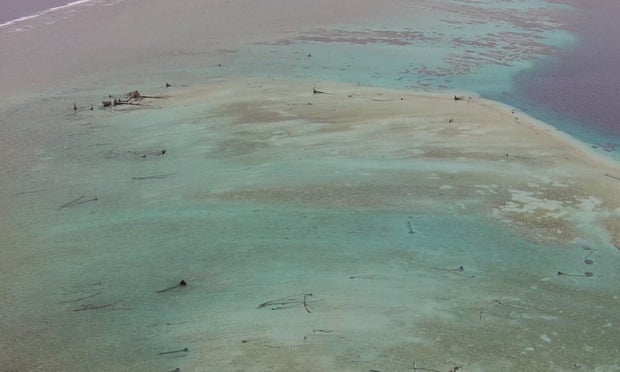
Five tiny Pacific islands have disappeared due to rising seas and erosion, a discovery thought to be the first scientific confirmation of the impact of climate change on coastlines in the Pacific, according to Australian researchers.
Solomon islands with the GeoGarage platform (NGA chart)
The submerged islands were part of the Solomon Islands, an archipelago that over the last two decades has seen annual sea levels rise as much as 10mm (0.4in), according to research published in the May issue of the online journal Environmental Research Letters.
The missing islands, ranging in size from 1 (2.5 acres) to 5 hectares (12.4 acres) were not inhabited by humans.
But six other islands had large swathes of land washed into the sea and on two of those, entire villages were destroyed and people forced to relocate, the researchers found.
One was Nuatambu Island, home to 25 families, which has lost 11 houses and half its inhabitable area since 2011, the research said.
Many of the Solomon Islands are low-lying and prone to flooding from rising seas.
Photograph: BBC NHU/Jon Clay/BBC NHU
The study is the first that scientifically “confirms the numerous anecdotal accounts from across the Pacific of the dramatic impacts of climate change on coastlines and people,” the researchers wrote in separate commentary on an academic website.
The scientists used aerial and satellite images dating back to 1947 of 33 islands as well as traditional knowledge and radiocarbon dating of trees for their findings.
The Solomon Islands, a nation made up of hundreds of islands and with a population of about 640,000, lies about 1,000 miles northeast of Australia.
Schriever Air Force Base hides in plain sight.
A half hour’s remove from Colorado Springs, near the western edge of the Eastern Plains, it emerges from the rolling auburn fields visible from lonely Colorado State Highway 94: a few squat buildings and parking lots, interspersed with monstrous domed antennas shaped like mutant golf balls.
No aircraft disrupt the serenity of the shortgrass prairie.
Schriever is the rare Air Force base that lacks a runway.
When he was commander of the 50th Operations Group, Col.
John Shaw called his institutional home “the greatest Air Force base the world has never seen.”
Schriever’s modest footprint contains one of the largest concentrations of classified areas in the service.
Many of its 8,000 military and civilian personnel toil underground.
Sharing the Colorado Springs area with Peterson Air Force Base, the Air Force Academy, the Army’s Fort Carson installation, and the NORAD nuclear bunker carved into Cheyenne Mountain, Schriever accounts for around half of the $6 billion the military pumps into the local economy each year, while maintaining a chronically low profile.
“Where is it exactly?” Shaw wondered rhetorically.
“And what do they do there? Who really knows?”
“What we do here is space,” said Brian Stewart, a young lieutenant and one of the first people I meet the day I visit Schriever.
“We’re good at it,” he added, “and you’ll see why.”
With active command over most Air Force satellites, and a lead support role for 175 satellites belonging to other branches of the military, the 50th Space Wing accounts for much of the work done at Schriever.
One of its components, the 50th Operations Group, has various units whose duties include overseeing the most top-secret military satellite communications networks.
But it is the Group’s 2nd Space Operations Squadron whose handiwork resonates the loudest.
All day, every day, 2 SOPS has one job: to monitor, maintain, and refine a fantastically complex system that affects nearly every person on earth.
They do their work in a windowless room at the end of a series of fluorescent-lit corridors, past sentries, passcard-protected doors that trigger alarms if left open too long, and signs authorizing the use of deadly force.
Inside, around a dozen people, working in twelve-hour shifts, array themselves on tiered rows, staring at monitors.
Some have advanced degrees, others are airmen barely out of high school.
Overhead screens and rotating siren lights signal the presence of visitors.
The captain on duty reminds the crew to hide from view any classified materials.
Military police are never far away.
This unassuming space is the Master Control Station for the Global Positioning System.
The crews here keep obsessive watch over a constellation of thirty-one GPS satellites, orbiting more than 20,000 kilometers above the planet.
Every few minutes, someone at the Master Control Station announces a “pre-pass” and recites steps from a checklist, a prelude to the crew contacting one of the satellites to update its data and perform maintenance.
Around the world, from Kwajalein Atoll in the Pacific to the south of England, sixteen far-flung monitoring stations collect data pertaining to each satellite’s signal as it comes over the horizon, noting its speed and trajectory.
The crunched numbers, based on 1,200 different protocols, tell the crews at Schriever how the satellite is performing, and whether they need to upload new instructions.
There is no room for error.
Some people here are monitoring the active atomic clocks aboard each GPS satellite, which are synchronized within nanoseconds to the clocks on every other satellite, all of which obey the Master Clock at the United States Naval Observatory in Washington D.C.
The satellites broadcast a continuous radio signal that carries information about where the satellite was and will be—and also the exact time the signal left the satellite.
The signal makes a 20,000-kilometer journey, taking an especial pummeling as it pushes through the earth’s ionosphere.
When it reaches us, sixty-seven milliseconds later, it is even fainter.
Captain Stephen Dirks, the supervisor of this shift, calls it a “whisper from space.”
When somebody fires up a mobile phone in New York, or London, or Tokyo, Karachi, Nairobi, Paris, Berlin, Kabul, São Paulo, Vancouver, Sydney, Budapest, or Johannesburg, the process is the same.
Nearly every spot on earth has a line of sight to at least four GPS satellites at all times.
The GPS receiver in the phone searches for the four strongest whispers.
By noting each signal’s origin and its arrival time, the receiver can compute the latitude and longitude of the phone, and express it as a point on a map.
The receiver can also provide the correct time.
Four satellites, four dimensions.
A pinpoint calculation of space and time.
This extraordinary system began as an American military application, a way to improve the accuracy of bombs and keep bomber pilots safe.
Today, its tentacles are everywhere.
GPS is, of course, a wildly popular positioning and navigation system.
Nearly 3 billion mobile apps clogging the world’s phones and tablets use some sort of GPS-derived positioning information.
Between now and 2019, that number will more than double.
GPS technology also undergirds an enormous portion of the international economy.
The estimated value of the global GPS market in 2011, around $9.1 billion, has now tripled.
Certain early GPS entrepreneurs rank among the world’s wealthiest individuals.
But the true economic influence of GPS resists quantification.
Factoring in the GPS chips in smartphones, tablets, and computers, moving platforms, such as cars, ships, and planes, and various products associated with service industries would produce a figure in the trillions of dollars—“so large,” according to GPS expert Len Jacobson, “that it is meaningless to anyone but a scholar.”
This is one of the first commercial GPS receivers.
TI-4100 NAVSTAR Navigator GPS Receiver Made by Texas Instruments in 1981, this is one of the first commercial GPS receivers and antennas. The National Geodetic Survey, the U.S. Geological Survey, and the Naval Surface Weapons Center at Dahlgren, Virginia, used such receivers for surveying the Earth’s precise shape.
The total number of GPS receivers across all technological platforms probably hovers somewhere around 5 billion.
We use GPS to track the movements of criminal suspects, sex offenders, wild animals, dementia sufferers, and wayward children.
GPS guides planes to the ground and orients ships at sea.
We wear watches with GPS.
We buy specialized GPS sporting applications for golfing and fishing.
We use GPS to locate oil deposits.
GPS has helped grow a significant amount of the food you will eat today.
GPS is itself one of the world’s most accurate clocks—and also a clock that unites other clocks.
The components and nodes of the world’s complex systems require time synchronization, often linked to GPS time.
GPS timekeeping helps regulate the electrical grid in all its transnational complexity, bounces your mobile phone conversation from tower to tower, chops up voice transmissions into component parts and reassembles them on the other side, and orders billions of transactions through financial trading networks, where millisecond discrepancies can effect billions of dollars.
GPS can record the movement of subatomic particles across hundreds of miles.
GPS helps predict the weather.
GPS surveys land, and builds bridges and tunnels.
It knows how much water is in the ground and in the ash plume rising from a volcano, and how the oceans help redistribute the planet’s center of mass.
GPS knows when the earth deforms; it senses the movement of tectonic plates down to less than a millimeter.
GPS can help tell us when an earthquake is imminent.
GPS can feel the glaciers melting as the planet heats up.
GPS is a global navigational satellite system, or GNSS.
Because of the high cost and complex infrastructure of developing and maintaining a GNSS, very few exist.
All are controlled by nation-states, and all operate on the same basic technological principles as GPS.
Only Russia’s GLONASS offers the equivalent full global coverage and a complete satellite constellation.
The development of the Galileo system, a project of the European Union and the European Space Agency, did not officially begin until the early twenty-first century.
The first Galileo satellite launched in 2011, and the program will require at least another decade to reach full operability.
China’s Beidou system, currently offering limited service, will mature around the same time.
By then, GPS will be even more fully entrenched.
GLONASS, currently plagued by technical problems, will still run a distant second.
Many GPS receivers are GLONASS-compatible, using the Russian satellites as a way to strengthen GPS calculations.
Even as the European and Chinese systems become more fully formed, and similar projects begun by Japan and India come online, they will likely serve a similar function, support beams in a building whose foundation is GPS.
Galileo and Beidou have political value for the countries that run them, a way to declare independence from the United States, but they will likely be “global” only in their coverage, not in their technological ubiquity.
The Air Force rightly calls GPS “the world’s only global utility.” It is universal, free for all, accessible by anyone, influencing everyone.
When an ISIS terrorist gets a GPS reading, the process is enabled by the United States military, which presides over every GPS calculation.
The U.S.
Department of Defense oversees GPS, with input from the Department of Transportation and other federal agencies, and day-to-day operations delegated to the Air Force.
The majority of the sixteen monitoring stations are controlled by the Pentagon’s spy agency.
Sensors onboard the satellites let them pull double-duty as nuclear-detonation detectors.
GPS is an essential part of virtually every weapons system.
To maintain it costs more than a billion dollars a year.
Like the Internet, GPS arose partly out of Cold War imperatives.
(It is no historical accident that the closest facsimile to GPS today is GLONASS, begun by the Soviets a few years after the US launched GPS.) Although it is less visible, GPS’s influence on the world equals or exceeds that of the Internet.
(The Internet could not operate without precision timing controlled by GPS.) This seems odd because while the Internet is a vast database, a way to aggregate and share information, GPS is just a radio pulse, a descendant of the rhythmic blip emitted by Sputnik.
But this whisper is so dependable, so ordered and clean, that GPS has become our heartbeat.
If it failed tomorrow, our society would experience enormous disruptions and scientific setbacks.
Those who oversee GPS have to maintain an almost unimaginable degree of exactitude.
Something as subtle as the pressure of the sun’s rays can shift a satellite’s orbit.
And the clocks cannot falter.
The integrity of the entire system rests on measuring the distance between you and the satellite by timing the arrival of its pulse.
Those signals are traveling at the speed of light.
A timing error of just one-millionth of a second will translate into a distance error of 200 miles.
Put another way, a clock with a margin of error of .000001 seconds might locate a New Yorker close to Washington, D.C., or a Parisian in the vicinity of Brussels.
Your GPS receiver, the one in your phone, is accurate to within a few meters.
Even with all that—the Master Control Station engineering the satellites, the clocks measuring time with rubidium atoms, so accurate they will not fall out of lockstep in millions of years—it still isn’t enough.
Like particle accelerators, and few other human-made operational systems, GPS must account for Einstein’s laws of relativity.
Compared to clocks on earth, time passes slightly more slowly for the clocks onboard the satellites, which speed around the earth at 2.4 miles per second.
The GPS signal contains instructions for the receiver to correct its calculations accordingly.
The difference is just a few microseconds every day, but if the system did not account for it, timing errors would multiply and distance calculations would soon be off by thousands of miles.
This book tells the story of GPS and how it grew from a fledgling military project to a ubiquitous technology that blankets the world.
The heartbeat emanating from those thirty-one GPS satellites gives us the power to measure and obtain enormous amounts of information about our planetary environment, physical space, and human behavior.
Its invention has led to an explosion of creativity in science, technology, and business.
For better or worse, it forms an essential part of the infrastructure of modern life.
But there is a price: the system may fundamentally change us as human beings.
We so rely on GPS, have integrated it so deeply into our lives, that it may be altering the nature of human cognition—possibly even rearranging the gray matter in our heads.
It is so potentially invasive that it forces us to reconsider cherished notions of privacy.
We have let it saturate the world’s systems so completely that it is difficult to imagine life without it, and so quickly that we are just beginning to confront the possible consequences.
A single GPS timing flaw, whether accidental or maliciously installed, could bring down the electrical grid, hijack drones, or halt the world financial system.
We now trust our devices so much that we follow them blindly down abandoned roads, over cliffs, and into the ocean; park rangers call this “death by GPS.”
The story of GPS is also one of human ingenuity.
At Schriever, they tell visitors that GPS is officially divided into three segments.
The first is the space segment: the satellites.
Next is the control segment: the tracking stations and the facilities that upload ephemeris corrections to the satellites.
The third, the largest, is the user segment: every one of the world’s GPS receivers.
Workers at the Master Control Station like to point out that they are only responsible for the first two.
Once the signal leaves the satellite, their job is done.
The rest is up to us.
GPS reaches us as a whisper.
We give it a voice.
Listen closely, and it will tell the story of the world today.