The divers of the Mexican Liveaboard SolmarV encountered an unusually friendly humpback whale mama with her newborn who allowed them unparalleled close encounters underwater.
The next day 2 Orcas showed up at the dive site and executed natures plan of order....
A Street View Trekker mounted on an autonomous Wamv robot passes the Exploratorium. and see the San Francisco Shoreline streetview imagery in Google Maps at maps.google.com/ocean.
Recent visitors to San Francisco Bay might have spotted something strange: a small unmanned vessel zipping through the water with a mysterious sphere mounted atop its two parallel hulls. “What is that?” one bystander asked recently, as the watercraft hugged the shoreline off of Fort Mason. “Is it a water drone?” asked another.
For the past few months, the nonprofit San Francisco Baykeeper has been remotely piloting the craft — a catamaran topped with a loaner Google Street View camera. In a teaming of tech and environmental advocacy, Baykeeper is using the camera’s 360-degree imagery to capture the shoreline’s rising sea levels, mapping a meandering 400 miles of the bay’s coast.
The idea is to give people a close-up view of the shore, the kind of view typically available only from a boat. This, Baykeeper hopes, will rile them up. “A lot of people know about sea level rise,” said Sejal Choksi, an environmental lawyer and Baykeeper’s interim director.
“We are hoping these images will really bring the reality home to the public, that they will look at pictures of places they know and say, 'Oh my gosh, this is going to be underwater.’” Google’s Street View cameras have been affixed to cars, boats, people and even camels. But this catamaran, a Wave Adaptive Modular Vessel that keeps the camera steady even as the tide swells, is a first.
Baykeeper initially planned to use kayaks and GoPro cameras to document small parts of the bay. After Baykeeper won a $100,000 grant from Google, though, the Mountain View tech giant offered up its imaging gear. The camera consists of 15 lenses atop a mast, each angled in a different direction to be stitched together to create a panoramic view.
The catamaran is battery-operated, and controlled via joystick from Baykeeper’s patrol boat. “It’s basically a large-scale video game,” said Karin Tuxen-Bettman, a Google employee and wetlands-mapping expert who is helping Baykeeper with the project.
Baykeeper began mapping in October.
After more than 20 eight-hour days on the water, the organization has documented 300 miles of shoreline, including wetlands and deltas. Already, the mapping expeditions have proven revelatory, said Ian Wren, Baykeeper’s staff scientist. “We noticed in some areas the wetlands are just a few inches above high tide,” he said.
“That means they are at risk for flooding, which could destroy those ecosystems.”
Wren has also discovered abandoned ships at risk of polluting the bay as they rot. Once the mapping is done, Baykeeper will display the images in interactive maps on its website. They will also be available through Google’s popular Street View tool. “A lot of agencies talk about sea level rise, but there is not a lot of public input,” Choksi said.
“These kind of issues should be more community-based. They are local, regional problems.”
In addition to using the images to raise public awareness, the nonprofit hopes to establish a baseline against which researchers can measure sea levels in the future. There is significant research indicating that the global sea level is rising now at a faster rate than in the past.
The Global Mean Sea Level has risen by 4 to 8 inches since record keeping began in 1880. (Sea-level rise is caused by two main things: thermal expansion due to the warming of the oceans and the melting of land-based ice such as glaciers and polar ice caps.)
Baykeeper is not the first environmental group to receive Google’s Street View technology.
Through Google.org, the company’s nonprofit arm, Google has lent its cameras to researchers studying the Galapagos Islands, Tanzania’s Gombe National Park and the Colorado River, among other locations.
Nonprofits, researchers and government tourism agencies can apply to borrow the device.
Tuxen-Bettman said she hopes to eventually work with local governments and nonprofits to map all of the waterways feeding San Francisco Bay.
It might be useful for planning purposes, like documenting infrastructure that might need to be replaced or repaired. “We want people to see that this kind of information could really be useful,” she said.
Plastics weighing 191 times as much as the Titanic are dumped in the oceans every year as nations led by countries in Asia struggle to manage waste, the first study to quantify the problem showed.
Some
eight million metric tons of plastic waste makes its way into the
world’s oceans each year, and the amount of the debris is likely to
increase greatly over the next decade unless nations take strong
measures to dispose of their trash responsibly, new research suggests.
The report,
which appeared in the journal Science on Thursday, is the most
ambitious effort yet to estimate how much plastic debris ends up in the
sea.
Indian fishermen pushed their boat through plastic waste last month in Mumbai.
Jenna Jambeck,
an assistant professor of environmental engineering at the University
of Georgia and lead author of the study, said the amount of plastic that
entered the oceans in the year measured, 2010, might be as little as
4.8 million metric tons or as much as 12.7 million.
The paper’s middle figure of eight million, she said, is the equivalent of
“five plastic grocery bags filled with plastic for every foot of
coastline in the world” — a visualization that, she said, “sort of blew
my mind.”
By 2025, she said, the amount of plastic projected to be entering the
oceans would constitute the equivalent of 10 bags per foot of coastline.
The researchers then
projected the amount of waste going forward based on population growth
estimates.
Any walk along a beach will produce a sizeable haul of plastic waste
“This is a significant study,” said Nancy Wallace, director of the marine debris program at the National Oceanic and Atmospheric Administration, who saw the paper before it was published.
Ms.
Wallace applauded what she considered the sophisticated use of
available data to estimate the amount of plastic entering the marine
environment, both collectively and country by country.
“Of course we
know these aren’t absolute numbers, but it gives us an idea of the
magnitude, and where we might need to focus our efforts to affect the
issue,” she said.
In 2010, 192 countries produced a total of 2.5 billion metric tones of solid waste, including 275 million metric tons of plastic.
An estimated 8 million metric tons entered the ocean that year
The
research also lists the world’s 20 worst plastic polluters, from China
to the United States, based on such factors as size of coastal
population and national plastic production.
According
to the estimate, China tops the list, producing as much as 3.5 million
metric tons of marine debris each year.
The United States, which
generates as much as 110,000 metric tons of marine debris a year, came
in at No. 20.
While
Americans generate 2.6 kilograms of waste per person per day, or 5.7
pounds, to China’s 1.10 kilograms, the United States ranked lower on the
list because of its more efficient waste management, Professor Jambeck
said.
Inside the Garbage of the World Documentary from Philippe Carillo
Is the Plastic Trash Island floating in the Pacific Ocean a myth? Are we getting poisoned? How long do we have before a worldwide disaster happen?
Plastics
have been spotted in the oceans since the 1970s.
In the intervening
decades, masses of junk have been observed floating where ocean currents
come together, and debris can be found on the remotest beaches and in
arctic sea ice.
Debris from urban activities and runoff accumulates at the edge of Lake Michigan.
(Courtesy Jenna Jambeck/University of Georgia)
The
problem is more than an aesthetic one: Exposed to saltwater and sun,
and the jostling of the surf, the debris shreds into tiny pieces that
become coated with toxic substances like PCBs and other pollutants.
Research
into the marine food chain suggests that fish and other organisms
consume the bite-size particles and may reabsorb the toxic substances.
Those fish are eaten by other fish, and by people.
Cleaning
up the plastic once it is in the oceans is impractical; only a portion
of it floats, while most disappears, and presumably what does not wash
ashore settles to the bottom.
Any
collection system fine enough to capture the smaller particles would
also pick up enormous amounts of marine life.
So the best option,
Professor Jambeck and others suggest, is to improve waste management
ashore.
But
prodding developing countries to spend money on waste management is
difficult, she acknowledged.
“You’ve got critical infrastructure needs
first, like clean drinking water,” she said.
“It’s kind of easy to push
waste to the side.”
Over
the years she has pursued this line of research, Professor Jambeck
said, she has seen a strong, even visceral response from the public.
4Yacht, Inc. presents yacht project "Triple Deuce", a whopping 222 meters (728.4’) long, and the most expensive, at a cost of over one billion dollars... 4Yacht is not able to provide more details, such as the designer, or the volume. They did release information about the engines; triple gas turbine engines producing over 100,000 horsepower, powering electric podded propulsion units. Adding such features will almost certainly add more time to the total construction time, putting more pressure on the 2018 delivery date. Time will tell if construction of this project will eventually commence.
Introducing "Triple Deuce," set to be the world's biggest superyacht at a whopping 222 meters long.
At $1 billion, it will also be the most expensive private yacht ever built, costing more than the annual GDP of Western Sahara, the British Virgin Islands, and Micronesia.
The identity of "Triple Deuce's" owner remains secret.
Nonetheless, building a yacht of this size is all about "boasting rights," said Craig Timm of 4Yacht, broker of the record-breaking project.
"It's just like the competition to build the world's tallest building," he said of the commission, due to be completed in spring 2018.
"Project Deuce will cost $1.1 billion to $1.2 billion," added Timm.
"And don't forget to add in annual operating costs -- on a yacht of this size, it will run the owner up an additional $20 to $30 million per year."
The boat will be over 40 meters longer than the world's current biggest superyacht, "Azzam," believed to be owned by the President of the United Arab Emirates, Sheikh Khalifa bin Zayed Al Nahyan.
It will also trump Russian businessman Roman Abramovich's "Eclipse" by 58.5 meters.
At 180 meters long, "Azzam" is currently the biggest superyacht in the world... but for how long?
"Our client was concerned that if we built the yacht to 200 meters, then someone would come along like Roman Abramovich when he built "Eclipse" at 163.5 meters, and outdid Sheikh Maktoum's yacht, the 162 meter "Dubai," by only 1.5 meters," explained Timm.
"By building the yacht to 222 meters, the owner wants to make it difficult, if not impossible, to be 'eclipsed' himself."
As the race to build the world's biggest superyacht steps up a notch, is there a point when these floating palaces simply become "too big?"
"You can't really be 'too big' for the high seas. But these superyachts are now at such a size that many of them can't get into harbors," said John Kampfner, author of "The Rich: From slaves to superyachts, a 2,000 year history."
"So what they do is moor out at sea, and a small boat -- which is still enormous by the standards of ordinary mortals -- will take them to shore. Or they could always jump on their helicopter, because no self-respecting superyacht comes without a helipad these days."
In the past two decades average superyacht sizes have more than doubled, according to Gaelle Tallarida, managing director of the Monaco Yacht Show.
"Fifteen years ago a large yacht was 45 meters," she said.
"Whereas now it's 100 meters long, maybe even a little more," she said.
"And I think we have still not achieved the limit."
"Triple Deuce's" master suite alone encompasses two stories and stretches across 275 square meters -- including a private gym. The seven-deck superyacht also comes with two pools, numerous jacuzzi, and a hair stylist and barber.
Yet in a global climate of "haves and have-nots," is it morally justifiable to spend $1 billion on a private yacht catering for 36 guests?
"To be honest, what ordinary mortals think is 'moral,' is not actually relevant to these people," said Kampfner.
"You have to understand that we're not talking about the top 1% -- in this instance we're talking about the 0.01%. This is a tiny group who live in their own bubble, they mix only among themselves."
Timm sees things differently, pointing to the employment opportunities created during the building and running of the superyacht.
"The boat will take approximately two to three million human hours to build -- not counting all the worldwide subcontractor hours, or the ready-made items already available on the market ready to be installed on the yacht," he said.
"Building the yacht at the shipyard will directly employ, at the minimum, 500 people for a period of three years. These people, who have families to support and feed, will be gainfully employed.
"And this does not include the 50 to 70 people who will work on the yacht and will be employed full time by the yacht owner, as well as others who supply the yacht."
He extends this reasoning to the media -- "You, the journalist, benefits from this build indirectly by being gainfully employed by CNN for writing this story."
And you, the person reading this story?
Kampfer sees the public's interest in the lifestyles of the super rich as a type of luxury porn.
"There is an enormous sense of injustice which is shared not just by the poor, but also by the middle class, towards the global super rich," he said.
"But together with that however, is a sense of envy and ogling. So whether you call it confusion, or double standards, or hypocrisy, or whatever it might be -- we both abhor the lifestyles of the super rich and at the same time we are endlessly fascinated by them."
Coverage NZ Linz Marine GeoGarage layer As our public viewer is not yet available (currently under construction, upgrading to a new webmapping technology as Google Maps v2 is officially no more supported), this info is primarily intended to our universal mobile application users (Marine NZ iPhone-iPad on the Apple Store/ Weather 4D Android -App-in- on the PlayStore) and our B2B customers which use our nautical charts layers in their own webmapping applications through our GeoGarage API.
1 chart has been updated in the Marine GeoGarage
(Linz January update publishedFebruary 6, 2015 (Updated to NTM Edition 2, 23 January 2015)
NZ5324 Tamaki Strait and Approaches including Waiheke Island
Today NZ Linz charts (183 charts / 323including sub-charts) are displayed in the Marine GeoGarage. Note : LINZ produces official nautical charts to aid safe navigation in New Zealand waters and certain areas of Antarctica and the South-WestPacific.
Using charts safely involves keeping them up-to-date using Notices to Mariners Reporting a Hazard to Navigation - H Note : Mariners are requested to advise the New Zealand Hydrographic Authority at LINZ of the discovery of new or suspected dangers to navigation, or shortcomings in charts or publications.
In case you haven’t heard yet, humans are wreckingthe oceans.
That doesn’t just mean that significant swaths of ocean life could go extinct — it means some kinds of life could go extinct before we ever even know they existed at all.
In fact, scientists estimate that they have never even given a name
to some 33 to 91 percent of the different organisms living in the
global oceans.
(Given our lack of knowledge, the large range here is
understandable.)
“Just the other week, a paper came out saying that we might be facing a mass extinction in the ocean,” notes Smithsonian Institution marine researcher Nancy Knowlton.
“But actually, we don’t really know what lives in the ocean, apart from
a handful of large things like fishes, corals and some snails.”
Nancy Knowlton diving towards an “underwater condo,” freshly placed in the Red Sea.
Photo Credit: Michael Berumen
Knowlton
is part of a pretty clever research solution to this problem — what she
calls “underwater condos” (pictured above).
Their scientific name is
significantly less cool: ARMS, or Autonomous Reef Monitoring Structures.
The
condos are built out of square plates, in a stack of 10, with gaps that
let marine organisms go in and out.
They make a new home, so to speak,
and then scientists can remove the plates and see what actually lives
there. Like this:
An “underwater condo” plate.
Credit: Matthieu Leray
In a new study
out in the Proceedings of the National Academy of Sciences, Knowlton
and fellow Smithsonian Institution researcher Matthieu Leray report on
what these underwater homes have allowed them to do — namely, categorize
large volumes of marine life, including many previously unknown
species.
For the study, they examined plates from 18 condos that
had been installed on oyster reefs off the coasts of Virginia and
Florida.
Such oyster beds, notes the paper, are teeming with life, just
like coral reefs are –
and are in similar peril.
As many as 85 percent of them have been “lost
due to anthropogenic impacts,” says the study — meaning the life in and
around the beds may also have been lost.
The scientists used DNA
sequencing to rapidly process information about all the life found on
plates, sampling the DNA of the new organisms and matching it with known
sequences.
Not only did the researchers find that a large diversity of
life came to live in the condos — some 2,000 different types of living
things after the structures had been in place for 6 months.
But less
than 15 percent of the resulting genetic sequences corresponded with
known organisms whose DNA is already categorized in scientific
databases.
And, it is important to note, this was just from
sampling marine life off the coasts of Florida and Virginia.
There are
far more unexamined parts of the world ocean.
Fortunately, the condos work everywhere, says Knowlton. The Smithsonian’s MarineGEO program
has installed hundreds of them around the world in the hope of learning
more about species — before they vanish.
“We have them in 700 feet in
Curacao for example, on the carbon dioxide seeps of Papua New Guinea
that simulate an acid ocean of the future, and someday we hope to get
them to Antarctica,” Knowlton says.
That won’t save the oceans —
but it will definitely help create a much better DNA record of what
evolution toiled, over vast periods, to produce.
“When people
talk about threats to biodiversity or protecting biodiversity, until
these methods were developed we really didn’t know how to study it,”
says Knowlton.
Sailors navigating with sextant, compass
and maps found in the Marshall Islands that curved sticks and cowry
shells were far more sophisticated
In 1899, Charles Townsend and H.F. Moore—both scientists with the U.S. Fish Commission—set out on the steamer Albatross, the first ship of its size dedicated entirely to scientific research, for an expedition to the islands of the South Pacific.
The sailors aboard the Albatross navigated their way across the globe as U.S. sailors did at the time: with a compass and a sextant—a
tool that used the angles of the sun and the horizon to calculate
latitude—and, of course, maps.
At the end of the ship’s journey, though,
were sailors of a very different kind—sailors whose knowledge of the
ocean was based on cultural knowledge passed down through generations.
The stick charts of the Marshall Islands were first described for a Western audience in an 1862 edition of Nautical magazine by missionary L.H. Gulick.
“[The Marshallese] construct rude maps by which they retain and impart
knowledge regarding the direction and distance of the various groups” of
islands, he wrote.
“These maps consist of small sticks tied together in straight or curved
lines, intended to represent the currents or waves to be met, while the
islands are to be found at certain points where these lines meet.”
The chart is less a literal representation
of the sea,
but more an abstract illustration of the ways that ocean
swells interact with land.
(National Museum of Natural History)
Using funds that the Smithsonian had given them to collect
objects along their voyage, Townsend and Moore purchased one such chart,
which they gave to the National Museum of Natural History
in 1900.
But Gulick’s description of these “maps” wasn’t quite
accurate: The chart is less a literal representation of the sea, says
museum curator and anthropologist Adrienne Kaeppler,
and more an abstract illustration of the ways that ocean swells
interact with land.
Curved sticks, she explains, show where swells are
deflected by an island; short, straight strips often indicate currents
near islands; longer strips “may indicate the direction in which certain
islands are to be found;” and small cowry shells represent the islands
themselves.
In places like the Marshall Islands—a tiny nation of roughly 112 square miles, spread across 29 atolls and five islands—“Survival
depends on knowledge of and rapport with the sea,” Kaeppler says.
“This
requires knowledge of how to get across the sea, how to exploit it for
food, and what to do when devastated by it—[by] hurricanes, tidal waves,
or storms.”
The Marshallese built this essential knowledge by studying
the charts on land; by the time a sailor took to the ocean, he would
have fully absorbed the lessons contained within the patterns of the
sticks.
The stick chart is an instructional tool, one meant for use
before a voyage, rather than something to be used for real-time
navigation.
In places like the Marshall Islands, survival depends on a knowledge and rapport with the sea.
“They seem to have focused on one
particular environmental phenomenon, which is the waves and the
currents, and then developed that into a more elaborate system,”
explains Joseph Genz,
a professor of anthropology at the University of Hawaii who wrote his
dissertation on the subject. “They’re picking out repeating patterns in
the waves, and for them, those give reliable signals as to where land
is.”
As a graduate student
in 2005, Genz traveled to the Marshall Islands with a team of
anthropologists and oceanographers for what he calls a “revival
project.”
Traditional navigational knowledge, he says, was dying out
with the islands’ oldest generation, and the team from the University of
Hawaii agreed to help the elders document and resurrect the Marshallese
understanding of the seas.
Stick Charts and Water Wave Navigation
Using a combination of satellite imagery, computer modelling and a
buoy to measure wave frequency, size and direction, they were able to
“validate and confirm some of the local explanations with the scientific
explanations,” Genz says—but out on the water, away from their
equipment, the researchers still found themselves at a loss to explain
some of the things the Marshallese seemed to know instinctively.
“A lot
of times the navigator would say, ‘There’s the wave, can you feel it?’
and I’d say, ‘No, I can’t,’” he recalls.
“Part of it was trying to feel
what he was feeling, but not being able to see it.”
Hundreds of years ago, Pacific Islanders used voyaging canoes to travel.
They developed navigation techniques to steer across the ocean without instruments or charts.
The Marshall Islands is a nation in the western Pacific.
The land is formed from low-lying coral atolls and islands.
Many of the lessons contained within the stick charts, in other
words, have yet to be fully understood. “It’s quite possible that the
traditional knowledge of the ocean in the Marshalls could somehow
provide insight into science itself,” he says.
“So often, we think about
science as trying to make sense of everything else in the world, but it
could also be the other way around. This local oceanographic knowledge
might influence our scientific understanding as well.”
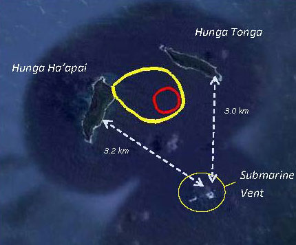
A Tongan volcano has created a substantial new island since it began erupting last month, spewing out huge volumes of rock and dense ash that has killed nearby vegetation, officials said.
Eruption between Hunga Tonga and Hunga Ha’apai island on 15 Jan, 39 miles northwest of the Tongan capital.
(New Zealand High Commission)
The volcano, about 65 kilometers (40 miles) northwest of the South Pacific nation's capital Nuku'alofa, rumbled to life on December 20 for the first time in five years, the Lands and Natural Resources Ministry said.
It said the volcano was erupting from two vents, one on the uninhabited island of Hunga Ha'apai and the other underwater about 100 meters (328 feet) offshore.
Map of the new island (Matangi Tonga) position with Google Maps
This picture taken on March 19, 2009 shows an aerial photo of ash rising into the air from an undersea volcanic eruption, part of the uninbabited islet of Hunga Ha'apai
(Telusa Fotu/AFP/Getty Images)
The ministry said experts took a boat trip to view the eruption on Thursday and confirmed it had transformed the local landscape.
"The new island is more than one kilometer (0.6 mile) wide, two kilometers (1.2 miles) long and about 100 meters (328 feet) high," it said in a statement.
"During our observations the volcano was erupting about every five minutes to a height of about 400 meters (1,312 feet), accompanied by some large rocks... as the ash is very wet, most is being deposited close to the vent, building up the new island."
It said ash and acidic rain was deluging an area 10 kilometers (6.2 miles) around the volcano, adding: "Leaves on trees on Hunga Tonga and Hunga Ha'apai have died, probably caused by volcanic ash and gases."
Pleiades image (July 2, 2014)
CNES/Airbus
An exceptional satellite image taken by the European Pléiades satellite from 19 January shows the new island that formed during the eruption near Hunga Ha’apai island (left in images) earlier in January month and joined it by forming a new peninsula, composed of a broad, flat ash cone with a water-filled crater.
The image also shows that activity seems to have already stopped by 19 Jan when the image was taken. Most likely, the new land addition will be eroded within months, because it seems mainly to be composed of loose materials, as opposed to more resistant solid lava flows.
A number of international flights were cancelled earlier this week amid concerns about the volcano's ash plume but they resumed, with authorities saying debris from the eruption was not being thrown high into the atmosphere.
Tonga, which is almost 2,000 kilometers (1,243 miles) northeast of New Zealand, lies on the so-called Pacific "Ring of Fire", where continental plates collide causing frequent volcanic and seismic activity. Links :
If this picture does not sum up how wrapped up we are in our electronics then nothing ever will.
A photo posted to Instagram
Tuesday by professional photographer Eric Smith shows a man so
engrossed in his phone that he fails to notice an enormous humpback
whale swimming next to the boat just feet away.
Smith
wrote on the post that he captured the symbolic moment a few weeks ago
on a whale watching trip off Redondo Beach. He didn't miss the moment.
He saw a whale and her calf breach about 50 feet away from him when they
resurfaced next to the sailboat.
He wrote that while two women at the front of the boat were taking pictures, the cell phone guy was oblivious.
In an interview with ABC News, Smith said he took five photos of the whale next to the sailboat and that the man did not look up once.
"He
could have been texting his mom in the hospital for all I know, but I
thought it sucked that he missed such a wonderful moment happening just
two feet in front of him," Smith told the network.
As John Lennon famously said, "Life is what happens while you are busy making other plans." (Or busy playing Flappy Bird?)
If you're not like cell phone dude and love seeing animals up close in the wild, here are more great whale and other photos Smith shot that day, including one of a dolphin jumping completely out of the water. His website can be found here.