Saturday, June 29, 2019

Image of the week : Mariana Trench inverted

 The Mariana Trench Is the deepest place on earth.
Here is what the region would look like as a mountain if it was inverted.
The elevation in the map is exaggerated by 5x so in real life the slope is 5 x shallower

courtesy of xkcd

Friday, June 28, 2019

As countries battle for control of North Pole, science is the ultimate winner

courtesy of N. Desai / Science

From ScienceMag by Richard Kemeny

A competition for the North Pole heated up last month, as Canada became the third country to claim—based on extensive scientific data—that it should have sovereignty over a large swath of the Arctic Ocean, including the pole.
Canada's bid, submitted to the United Nations's Commission on the Limits of the Continental Shelf (CLCS) on 23 May, joins competing claims from Russia and Denmark.
Like theirs, it is motivated by the prospect of mineral riches: the large oil reserves believed to lie under the Arctic Ocean, which will become more accessible as the polar ice retreats.
And all three claims, along with dozens of similar claims in other oceans, rest on extensive seafloor mapping, which has proved to be a boon to science, whatever the outcome for individual countries.
The race to obtain control over parts of the sea floor has "dramatically changed our understanding of the oceans," says marine geophysicist Larry Mayer of the University of New Hampshire in Durham.

Coastal nations have sovereign rights over an exclusive economic zone (EEZ), extending by definition 200 nautical miles (370 kilometers) out from their coastline.
But the 1982 United Nations Convention on the Law of the Sea opened up the possibility of expanding that zone if a country can convince CLCS that its continental shelf extends beyond the EEZ's limits.

Most of the 84 submissions so far were driven by the prospect of oil and gas, although advances in deep-sea mining technology have added new reasons to apply.
Brazil, for example, filed an application in December 2018 that included the Rio Grande Rise, a deep-ocean mountain range 1500 kilometers southeast of Rio De Janeiro that's covered in cobalt-rich ferromanganese crusts.

Canadian and U.S. Coast Guard ships worked together to map the Arctic sea floor for continental shelf claims.
DVIDSHUB/Flickr

To make a claim, a country has to submit detailed data on the shape of the sea floor and on its sediment, which is thicker on the shelf than in the deep ocean.
The data come from sonar, which reveals seafloor topography, and seismic profiling, which uses low-frequency booms to probe the sediment.
Canada's bid also enlisted ships to conduct high-resolution gravimetry—measurements of gravity anomalies that reveal seafloor structure.
Elevated gravity readings are found over higher-density mantle rocks found in oceanic crust, and lower readings over lighter, continental structures.
And the bid used analyses of 800 kilograms of rock samples dredged up from the sea floor, whose composition can distinguish continental from ocean crust.

The studies don't come cheap; Canada's 17 Arctic expeditions alone cost more than CA$117 million.
But the work by the three countries vying for the Arctic—and that of dozens of others elsewhere in the world—has been a bonanza for oceanography.
In the Arctic alone, the mapping has revealed several sunken mountains, previously missed or undetected by older sonar methods.
Hundreds of pockmarks found on the Chukchi Cap, a submarine plateau extending out from Alaska, suggest that bursts of previously frozen methane have erupted from the seabed, a phenomenon that could accelerate climate change.
And gaps discovered across submarine ridges allow currents to flow from basin to basin, with "important ramifications on the distribution of heat in the Arctic and on overall modeling of climate and ice melting," Mayer says.

CLCS, composed of 21 scientists in fields such as geology and hydrography who are elected by member states, has accepted 24 of the 28 claims it has finished evaluating, some partially or with caveats; in several cases, it has asked for follow-up submissions with more data.
Australia was the first country to succeed, adding 2.5 million square kilometers to its territory in 2008.
New Zealand gained undersea territory six times larger than its terrestrial area.
But CLCS only judges the merit of each individual scientific claim; it has no authority to decide boundaries when claims overlap.
To do that, countries have to turn to diplomatic channels once the science is settled.

The three claims on the North Pole revolve around the Lomonosov Ridge, an underwater mountain system that runs from Ellesmere Island in Canada's Qikiqtaaluk region to the New Siberian Islands of Russia, passing the North Pole.
Both countries claim the ridge is geologically connected to their continent, whereas Denmark says it is also tied to Greenland, a Danish territory.
As the ridge is thought to be continental crust, the territorial extensions could be extensive.
(U.S.
scientists should finish mapping in the Arctic in about 2 years, says Mayer, who is involved in that effort, but as one of the few countries that hasn't ratified the Law of the Sea convention, the United States can't file an official submission.)

Tensions flared when Russia planted a titanium flag on the sea floor beneath the North Pole in 2007, after CLCS rejected its first claim, saying more data were needed.
The Canadian foreign minister at the time likened the move to the land grabs of early European colonizers.
Not that the North Pole has any material value: "The oil potential there is zip," says geologist Henry Dick of the Woods Hole Oceanographic Institution in Massachusetts.
"The real fight is over the Amerasian Basin," Dick says (see map, above) where large amounts of oil are thought to be locked up.

It will take years, perhaps decades, for CLCS to rule on the overlapping Arctic claims.
Whoever wins the scientific contest still faces a diplomatic struggle.

Denmark, Russia, and Canada have expressed their desire to settle the situation peacefully.
"Russia actually has played nice on this and stopped at the North Pole," rather than extending its claim along the length of the ridge, says Philip Steinberg, a political geographer at Durham University in the United Kingdom.
Denmark had no such qualms and put in a claim up to the edge of Russia's EEZ, "even though there's no way in hell they'll get that," when it comes to the diplomatic discussions, Steinberg says.

One solution would be to use the equidistance principle, by drawing a median line between the coastlines, as has been done when proposed marine territories overlapped in the past; doing so would mean the North Pole falls to Denmark.
There's also a proposal to make the pole international, like Antarctica, as a sign of peace, says Oran Young, a political scientist at the University of California, Santa Barbara.
"It seems a very sensible idea."

Links :

Thursday, June 27, 2019

Investigation finds unintended risks with ECDIS navigation

The ATSB investigation of the grounding of the Australian Border Force Cutter (ABFC) Roebuck Bay on Henry Reef has revealed underlying safety issues with the effectiveness of ECDIS type-specific training, ECDIS software updates and the use of a single point feature to represent relatively large physical features on electronic navigational charts.

From Maritime Executive

The newly-released Australian Transport Safety Bureau (ATSB) investigation of the grounding of the Australian Border Force Cutter (ABFC) Roebuck Bay on Henry Reef has revealed underlying safety issues with the effectiveness of ECDIS type-specific training, ECDIS software updates and the use of a single point feature to represent relatively large physical features on electronic navigational charts.

Henry reef
Source: Australian Border Force, modified by the ATSB 
Charted position of Henry Reef point feature object on ENC
Image showing the charted 'point' position of Henry Reef as encoded in the ENC in relation to the actual reef. Note that the relative size of the isolated danger symbol to the reef is approximate only and that on the ECDIS display, the isolated danger symbol always displays at its standard size of about 7 mm regardless of scale.
Source: DigitalGlobe, Esri, modified and annotated by the ATSB

On September 30, 2017, shortly after midnight, the ABFC Roebuck Bay grounded on Henry Reef in the Great Barrier Reef, Queensland.
The cutter was on a passage from Saibai Island in the Torres Strait Islands archipelago bound for Lizard Island, located about 71 nautical miles south-east of Cape Melville.

Section of ENC AU413143 showing CATZOCs and ABFC Roebuck Bay's routes compared to advice in the Admiralty Sailing Directions
Source: Australian Hydrographic Office, annotated by the ATSB using information from the Australian Border Force and from Admiralty Sailing Directions (NP15)

The cutter sustained substantial damage to the keel, stabilizer fins and propellers, with hull breaches near the storage void and tank compartment spaces.
There were no reported injuries or oil pollution.


While planning the passage from Saibai Island in the Torres Strait Islands archipelago to Lizard Island, south-east of Cape Melville, ABFC Roebuck Bay’s previously used passage plan was amended, with its route inadvertently plotted over Henry Reef.

 Henry reef with the GeoGarage platform (AHS raster charts)

 Survey data (left) and section of paper chart Aus 836 (right)
Image shows Henry Reef as surveyed (left) and Henry Reef represented by the ‘coral pinnacle’ symbol (right) on the paper navigational chart Aus 836.
Source: Australian Hydrographic Office, annotated by the ATSB 
Henry Reef on ENC AU413143, displaying conditional symbology
Image on left shows Henry Reef displayed as a ‘rock awash’ symbol when lying within the user-defined safety contour. The image on the right shows Henry Reef displaying as an ‘isolated danger symbol’ when lying outside the user-defined safety contour.
Source: Australian Hydrographic Office, annotated by the ATSB
Images show AHO survey data (left), section of ENC AU413143 (centre) and ENC AU413143 superimposed on survey data at compilation scale (right).
Source: Australian Hydrographic Office, modified, annotated and superimposed by the ATSB
  
The ship’s electronic chart display and information system (ECDIS) identified the reef as a danger to the planned route, however, the crew did not identify the danger either visually or by using ECDIS.
The vessel continued on the amended route and grounded on Henry Reef just after midnight.
There were no reported injuries or oil pollution, but the vessel sustained substantial damage.

The ATSB found the crew’s ability to check the amended route was limited as their training was not effective in preparing them for the operational use of their on board ECDIS.

Image from ABFC Roebuck Bay’s ECDIS display, taken after the grounding, showing the previously used route (orange) and the amended route (red) based on the changed waypoints, W19 and W20.
Source: Australian Border Force, modified and annotated by the ATSB
ABFC Roebuck Bay's planned route on the ECDIS showing the relative position of the isolated danger symbol representing Henry Reef at different scales
Image shows ABFC Roebuck Bay’s amended route legs on the ECDIS at the compilation scale of 1:90,000 (left) and at the largest viewable scale, 1:500 (right).
Source: Electrotech and ATSB

The ATSB says the investigation highlights that the safe and effective use of ECDIS as the primary means of navigation depends on operators being thoroughly familiar with the operation, functionality, capabilities and limitations of the specific equipment in use on board their vessel.
“ECDIS type-specific training needs to be designed, delivered and undertaken so operators have the required knowledge to confidently operate ECDIS as intended by the manufacturer,” ATSB Chief Commissioner, Greg Hood said.

The ATSB also found the vessel’s ECDIS was not updated to the latest International Hydrographic Organization (IHO) standards and lacked the enhanced safety features of a new presentation library of symbology.

The ATSB reminds regulators, manufacturers, hydrographic offices and other concerned parties that their ultimate goal must be to eliminate the significant risks with the use of ECDIS or at least reduce them to an acceptable level in terms of navigational safety.
“Like all on-board equipment, ECDIS needs to be maintained and compatible with the latest applicable standards,” Mr Hood said.
“With the recent introduction of ECDIS as the sole means of marine navigation and the replacement of paper charts, the grounding was an opportunity for the ATSB to explore any potential safety impact of ECDIS in a real-world operational environment.”

The investigation involved interviews with Australian Border Force officers, crew and shore staff and hydrographers from the Australian Hydrographic Service and the ECDIS manufacturer.
Extensive ECDIS analysis was also carried out, as was various ECDIS simulations and testing.

“As a result of the investigation, the ATSB considers the use of point features in electronic navigational charts to represent areas of relatively significant size on the earth’s surface is likely to increase the risk of the hazard posed by such features being misinterpreted and potentially reduce the effectiveness of ECDIS safety checking functions,” Hood said.
“While this did not specifically contribute to the grounding of Roebuck Bay, the investigation has shown that the implementation of ECDIS has introduced some unintended risks to marine navigation.”

ECDIS display in the two colour scheme (L) and four colour scheme (R)
Source: U.S. Chart No.1, National Oceanic and Atmospheric Administration and National Geospatial-Intelligence Agency, modified and annotated by the ATSB

The ATSB recognises that ECDIS and electronic navigational charts are an essential tool for navigation with many safety benefits; however, operating crew need to be aware that navigating with ECDIS is fundamentally different from navigation with paper charts.
Hood says operating crew need to be aware that navigating with ECDIS is fundamentally different from navigation with paper charts.
“By allowing operators to view and change an electronic navigational chart to a larger complication scale, ECDIS can make single point features representing rocks, wrecks and other obstructions appear progressively smaller as the scale is changed, creating the impression it is clear of a ship’s route or further away than what it actually is.”

 Image of ENC AU413143 showing no overscale pattern
Image of a VisionMaster FT ECDIS display showing ENC AU413143 at a scale of 1:5,000 and displaying no overscale pattern.
Source: Northrop Grumman Sperry Marine, modified by the ATSB 
Image shows ENC AU413143 centred on Henry Reef, at a scale of 1:40,000 on a VisionMaster FT ECDIS, demonstrating text and symbol overlap.
Note that all text is on display as required by the Annex A - ECDIS start-up checklist.
Source: Electrotech and ATSB
  Comparison of area features and point features at different scales
The images demonstrate a key difference between area features, which change size proportionate to the scale at which the ENC is being viewed, and point features, which remain the same size regardless of scale.
The top picture is at scale of 1:40,000 and lower picture is at 1:20,000.
Source: Electrotech, modified by the ATSB

ECDIS is a complex software-based system and the ATSB acknowledges the many challenges faced in its design, manufacture, and operation to ensure navigational safety.
“The ATSB safety message from this investigation reminds regulators, manufacturers, hydrographic offices and other concerned parties that their ultimate goal must be to eliminate the significant risks with the use of ECDIS or at least reduce them to an acceptable level in terms of navigational safety,” Mr Hood said.

The report is available here / investigation

Links :

Wednesday, June 26, 2019

This is how China can be a friend to ocean conservation


China is the world’s biggest ocean farmer
Image: Reuters/Stringer

From Web Economic Forum by Douglas McCauley

An industrial revolution is beginning in the oceans.
Historically, the most valuable commodities drawn from the sea were products like cod, pearls, and sponges.
The currencies of this new ocean economy are different: kilowatts of energy, shipping containers, metals, data, desalinated water, DNA, and oil, to name a few.
The marine industrial economy has been valued at $1.5 trillion and is predicted to grow at double the rate of the rest of the global economy by 2030.

A sometimes unappreciated aspect of this recent explosive industrial marine growth is that its distribution is highly uneven.
In fact, many key facets of the new ocean economy have been dominated by one nation: China.

Image: Benioff Ocean Initiative, with data from FAO, Our World in Data, and The World Bank

China, for example, leads the world in industrial fishing.
It accounts for over half of all the industrial fishing that happens in international waters – the high seas – and Chinese vessels fish in the national waters – exclusive economic zones – of about 40% of all non-landlocked nations.

China is also the world’s biggest ocean farmer – an observation of significance in a world where fish farming now feeds more people than fishing.
It is a leader in global ocean commerce with over half of the world’s busiest ports located within China.

It is also actively building power plants in the sea.
China accounts for 20% of total global offshore wind installations.
China has emerged at the forefront of ocean mining.
It has sponsored the largest of all seabed mining exploration claim areas awarded by the International Seabed Authority to single-state sponsored mining companies for a total of up 163,000 km2 – an area about four times the size of Switzerland.

China's role in the marine industrial revolution looks likely to be buoyed further by increased investments associated with the 21st Century Maritime Silk Road and direct commitments in China’s current five-year plan to expand its “blue economy.” This includes the construction of new ports at home and abroad, scaling up desalination infrastructure, and making new investments in deep-sea exploration.

A crude oil tanker at Qingdao Port, Shandong province
Image: REUTERS/Jason Lee - RC1ECF749E60

Some of China’s recent global maritime growth has come with growing pains both for China and its global ocean neighbors.
China, for example, not only leads the world in fishing, aquaculture, and shipping – it also leads the world in production of marine plastic pollution: nearly a third of the total global mismanaged plastic waste available to enter the oceans comes via China.

This issue, however, is complex: China’s comparatively high plastic pollution leakage is shaped by both the nation’s large population and economic growth, and its historic practice of importing much of the rest of the world’s recyclables (a practice the nation scaled back significantly in 2018).

China’s leadership in the global oceans of today creates a defined opportunity and great imperative for China to also lead efforts to shape the ocean of tomorrow.

There is much opportunity for China to step up.
In 2017, The United Nations Ocean Conference gave governments the opportunity to register Voluntary Commitments to support the UN’s ocean-related Sustainable Development Goals.

While the Dominican Republic, a small island nation with a GDP of approximately $76 billion , made 43 such commitments for the ocean, China, with a GDP of over $12 trillion, made only five.
In a similar vein, the island state of Palau has protected 81% of its national waters while China has officially protected 5.4% of its marine waters and has placed less than 0.01% of these zones under strong protection.

Charting the course ahead

China’s record on ocean leadership stands in sharp contrast to contributions it has recently made to protect and promote other global environmental commons.
Perhaps most notable is China’s recent ascendancy from zero to hero on the global climate change agenda.

There are many ways that China could step up its leadership on oceans.
For example, China could more directly lead the Asia-Pacific region in the development of national and international policies for promoting sustainable fisheries and stopping illegal fishing.

Similarly, China could invest more effort and money in advancing smart aquaculture in lieu of dirty aquatic factory farming in the region.
Sustainable aquaculture projects could help the country meet production targets, while also addressing regional nutritional security issues – without compromising ecosystem health or undermining the capacity of fishermen to deliver a steady supply of free-range seafood.

Beyond leadership on fishing and ocean farming, we also need more research that can help intelligently zone out ocean economic growth, rapid reductions of shipping emissions and marine pollution, and more ocean parks to protect ocean ecosystems that are becoming more stressed by climate change.

Creating a more ocean-friendly marine industrial revolution will require intergovernmental coordination, alignment of research agendas, and acceleration of smarter marine technologies.
China can’t do this alone but it can do a great deal to catalyze and accelerate the global momentum that is needed.

Positive steps have been made.
Over the past few years, China has penalized several of its distant water fishing vessels for violating international regulations and fishing illegally in the exclusive economic zones of other countries.
Licenses were revoked and fuel subsidies were cancelled for hundreds of these illegal operations.

More such leadership would be good for the oceans and good for China.
Efforts by China to more sustainably manage the 1.3 million km2 of national waters that it controls and the vast sections of other ocean in which it has influence would help to sustain the long-term flow of food and income from the ocean into the country, while strengthening regional stability and reducing the conflict that many experts forecast may arise from squabbling over an emptier ocean.

Indeed, the grand challenge for the marine industrial revolution will be figuring out how to take more from the ocean while harming it less.
There is much work to be done, and fast.

China is at the helm when it comes to shaping how the new ocean economy develops and what a marine industrial revolution will mean for global ocean health.
The question remains: where will China steer?

Links :

Tuesday, June 25, 2019

Copernicus's revolutionary ideas reorganized the heavens

His Life's workCopernicus is shown at work in a 20th-century painting by Jean-Léon Huens, commissioned by the National Geographic Society.

From National Geographic by Ernest Kowalczyk

This secretive astronomer devoted his entire life to sun-centered cosmic theories as larger questions of faith were dividing Europe nearly 500 years ago.


Rumors were circulating in the 1530s that Nicolaus Copernicus, a cathedral cleric in a small Polish city, had written a revolutionary theory on the cosmos.
To the frustration of many, however, the secretive clergyman was refusing to publish it.

Curiosity came from many quarters.
One letter, written in 1536, begged for more information.
It praised Copernicus’s “new theory of the Universe according to which the Earth moves and the Sun occupies the basic, and hence, central, position.” Its author was Cardinal Nikolaus von Schönberg, a prince of the Catholic Church.

By placing the sun at the center, Copernicus’s idea overturned the ideas devised by the second-century astronomer Ptolemy.
In Ptolemy’s theory the sun and planets orbited the Earth, which was regarded as the orthodox model across the Christian world.
Through decades of work, Copernicus had slowly and carefully found a new way of organizing the heavens, but his reticence kept these new ideas isolated from the public, who could only speculate about them.

A man of both science and faith, Copernicus lived during a time of great change in Europe.
A new flowering of humanist thought was spreading throughout the continent, as scholars and artists looked back to the classical era and brought its influence to bear on art, architecture, literature, politics, and science.
After Martin Luther published his Ninety-Five Theses in 1517, a religious revolution began that would roil the Catholic Church and form new denominations.
Throughout all this tumult, Copernicus held fast at the center, methodically crafting his own astronomical revolution.

Pope Gregory XIII presides over discussions for a new calendar. 16th-century painting
Photograph by Oronoz / Album
A century before Galileo’s persecution, the church’s attitude to- ward astronomy was more open.
The Julian calendar, then in use, had become so inexact that it fell out of time with the seasons. Copernicus submitted a statement to a 1512-16 council convened to address the problem, in which he called for more accurate observations.
A new “Gregorian” calendar with leap years was introduced under Pope Gregory XIII in 1582 and is still in use today.

A Renaissance man

Copernicus was born Mikolaj Kopernik in 1473, in Torun, Poland.
(Following the custom among scholars in the Renaissance, he later latinized his name.) A major port on the Vistula River, Torun was part of a loose grouping of rich, northern trading cities known as the Hanseatic League.
Copernicus’s father was a merchant, and historians speculate that he and his family dealt in copper, an association which gave rise to the family name.
When Copernicus was 10 years old, his father died, and he went to live with his mother’s brother, Lucas Watzenrode.
Later appointed the Bishop of Warmia in northern Poland, Watzenrode became an important patron to his nephew.
(See also: How table manners as we know them were a Renaissance invention.)

Ptolemy, whose venerated Earth-centered system was challenged by Copernicus,
is depicted in this 1476 painting by Pedro Berruguete.
photograph by Bridgeman / ACI

Copernicus began his university studies in 1491 at the Academy of Krakow (today the Jagiellonian University), which was then attracting some of Europe’s finest minds in mathematics and astronomy.
Cosmopolitan Krakow, full of merchants and intellectuals, was an exciting place to receive an education.
Reports of startling discoveries of new lands across the Atlantic by a Genoese sailor, Christopher Columbus, and the new humanist teachings of the Renaissance, were arriving in Poland from southern Europe.
Krakow was the adoptive home of the flamboyant Italian scholar Filippo Buonaccorsi, secretary to the Polish king and tutor to his children.

After several years, Copernicus was drawn to Italy, the epicenter of humanist learning at the time.
Whatever diffidence he later showed in his scientific theories, Copernicus did not lack funds or time to pursue a solid student career there.
In 1497 his uncle appointed him a canon at the cathedral of Frombork in his own diocese, even though Copernicus had begun his Italian studies a year before.
The position gave him ample financial security.
Well over a decade would pass before the absentee canon took up his duties on the chilly shores of the Baltic; in the interim, Copernicus dedicated himself to university life, first at Bologna, then at Padua, finally emerging as a doctor from the small university of Ferrara in 1503.

Higher education in this period was much more far-ranging than the specialism of a modern university.
His studies included the intricacies of civil and church law, deemed essential for a high-ranking career in the clergy.
In addition, Copernicus immersed himself in medicine and mathematics.
This pairing was regarded as natural, epitomized in the 16th-century humanist scholar Jakob Milich, who served as both a professor of mathematics and anatomy.
In his later career Copernicus would also be known as much as a physician as a mathematician.

Another discipline that intrigued Copernicus was the study of the stars, which encompassed both astronomy and astrology.
Today astronomy is regarded as a science, based on observation, while astrology—the idea that heavenly bodies affect the health and fortunes of people— is not.
In Copernicus’s time, however, scholars made no clear-cut distinction between the two.
Bologna University’s astronomer, for example, Domenico Maria de Novara, was tasked with providing astrological predictions for the city’s rulers and nobility.

Novara proved to be an important influence on the young Polish stargazer.
For a while, Copernicus lodged with him, and the two scholars made observations together.
The invention of the telescope would not take place for over a century, so the two men relied on naked-eye observation, using their knowledge of Greek to consult treatises translated from Arabic, or the ancient classical works, such as the writings of Ptolemy.
Some of Ptolemy’s assertions were already being questioned by Novara.
He introduced Copernicus to the work of Johann Müller, known by his humanistic sobriquet Regiomontanus, another skeptic of the Ptolemaic model.

On March 9, 1497, together with Novara, Copernicus made his first known astronomical observation: At 11 p.m.
both watched as the moon briefly eclipsed a distant star, Aldebaran, an event that cast doubt on Ptolemy’s theory of the distance of the moon from the Earth.
The idea that the Sun was fixed in the center of the cosmos was starting to take hold in Copernicus’s mind.

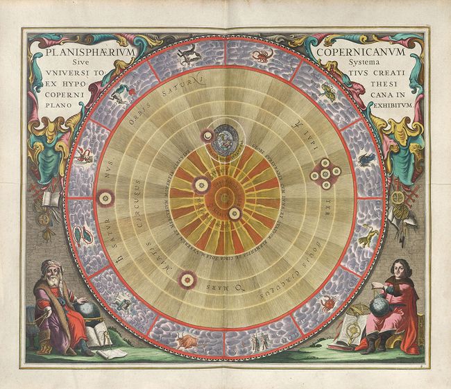
 The Copernican Planisphere, illustrated in 1661 by Andreas Cellarius.

A theory evolves

In 1503 Copernicus returned north to his uncle’s diocese in Poland.
He spent several years working alongside his uncle as both his secretary and personal physician.
He took part in minor acts of diplomacy on trips around Poland and also published a translation into Latin of a work by a seventh-century Byzantine historian.
After his uncle’s death in 1512, he devoted more time to the duties of a church canon, which were largely administrative: collecting rents, managing finances, securing military resources, and overseeing the local businesses (bakeries, breweries, and mills) of the diocese.

During this time Copernicus also continued his astronomical work.
He earned a solid reputation as a leading mind of the time.
In 1514 Copernicus was invited to contribute to a council to reform the calendar, so as to enable the church to fix feast days with more accuracy.
Later, as an administrator at the Bishop’s Castle in the Warmian city of Olsztyn, he produced an astronomical table, or heliograph, still visible on one of the walls of the castle cloister, for observing the movements of the sun.

Sometime before 1514, Copernicus wrote a small treatise, the Commentariolus (“little commentary” in Latin).
He circulated a few hand- written copies among a learned elite.
This small work, described by scholars as “a manuscript of six leaves,” first presented Copernicus’s notion that the Earth and other planets move while the sun stands still.
Using his observations and other research, Copernicus calculated the time each planet took to go around the sun: Mercury (88 days), Venus (225 days), Earth (one year), Mars (1.9 years), Jupiter (12 years), and Saturn (30 years).
This pamphlet was the first milestone in Copernicus’s journey to redefine the universe.

Copernicus observing the heavens from his tower at Frombork.
1873 oil painting by Jan Matejko
Photograph by Bridgeman / ACI
A tradition holds that Copernicus made astronomical observations from a tower in the cathedral complex at Frombork.
He found his adoptive home far from ideal for this purpose, and in De revolutionibus expresses his conservative view that things were better in classical times, especially in the land of Ptolemy: “The ancients had the advantage of a clearer sky; the Nile does not exhale such misty vapors as those we get from the Vistula.”

Gaining ground

The Commentariolus’s early findings raised questions and exposed problems with the data.
To avoid errors in his calculations and assumptions, Copernicus spent decades of his life finding the strongest evidence to support his epoch- shaking idea.
The Commentariolus was only circulated among a few scholars and caused very little commotion.

In the meantime, Copernicus was busy with his duties with the church, whose very foundations were shaken by Martin Luther’s dramatic challenge to papal authority in 1517.
Throughout the 1520s he helped steer his diocese through the ensuing conflict, taking part in diplomatic missions and even proposing reforms to the monetary system.

Many years later, the Commentariolus came to the attention of German humanist Johann Albrecht Widmannstetter.
In 1533 he gave a lecture in the Vatican gardens before Pope Clement VII and explained Copernicus’s still unpublished theory.
The church’s interest in his work was genuine, and at this time did not see a sun- centered universe as threatening to orthodoxy.

A young Austrian mathematics professor, Georg Joachim Rheticus, was instrumental in helping Copernicus push heliocentrism out to the wider world.
In 1539 Rheticus moved to Frombork to work alongside the astronomer for two years and became Copernicus’s devoted disciple.

After much per- suasion, Rheticus finally managed to convince Copernicus to let him publish an account of his theory in 1540.
The treatise, called The First Account of the Book on the Revolutions by Nicolaus Copernicus, piqued the interest of astronomers all over Europe.
They would not have to wait long for a full accounting of Copernicus’s astronomical work.

 Armillary sphere
A classic, Earth-centered, brass model made in 1549.
The rings show the sun’s annual path, equinoxes, solstices, and the zodiac.
Pinacoteca Ambrosiana, Milan
Photograph by Bridgeman / ACI

Mapping the stars

Two years later, the manuscript of De revolutionibus orbium coelestium libri VI (Six Books Concerning the Revolutions of the Heavenly Orbs), was taken to Nuremberg to be printed by a leading scientific publisher.
The lavishly illustrated work included 142 woodcuts.
There is evidence that Copernicus made numerous corrections and edits to the first part of the work.


This instrument was used to measure the position of heavenly bodies according to the degrees marked in a semicircle. 1784.
Brera Astronomical Observatory, Milan
Photograph by Bridgeman / ACI

A popular story (perhaps apocryphal) is that a first edition of the book was brought to his deathbed as he lay dying from a stroke in 1543.
Copernicus drew his last breath on May 24, having completed his work.
Now the rest of the world would see how this humble cleric would reorganize the heavens.

Triquetrum
With its slanted arms, this instrument could measure how high an astronomical object was in the sky. The image shows a replica of the instrument used by Copernicus.
Photograph by Bridgeman / ACI

Moving heaven and earth

De revolutionibus expands the fundamental ideas put forth in Commentariolus.
It declares that the Earth orbits the sun in the course of a year, turns around its own axis in the course of a day, and annually tilts on its axis.
His sequencing of the planets from the sun—placing the Earth third in line—was to become the accepted order.
In his introduction, addressed to Pope Paul III, he explains why he took so long to publish his work:

[T]he scorn which I had reason to fear on account of the novelty and unconventionality of my opinion almost induced me to abandon completely the work which I had undertaken.

His friends were able to convince him otherwise:
As crazy as my doctrine of the earth’s motion now appeared to most people, the argument ran, so much the more admiration and thanks would it gain after they saw the publication of my writings dispel the fog of absurdity by most luminous proofs.

In other ways, however, Copernicus did not break new ground.
Solar centrality was not a new idea, as he acknowledged: “I first found in Cicero that Hicetas [a Greek philosopher from the fourth century B.C.] supposed the earth to move.”

Copernicus also got some things wrong.
He held on to the idea that orbits were perfectly circular, which was later disproved by Johannes Kepler, who demonstrated that orbits are elliptical.
In order to reconcile circular orbits with actual planetary behavior, Copernicus continued the tradition, developed by Ptolemy, of arguing that planets spin on wheels, known as epicycles.

Upon its publication, the Catholic Church was not hostile to De revolutionibus.
Copernicus had made no attempt to challenge papal authority in his writings, and his dedication goes to great lengths to establish his respect for the pope.
By the 1560s several universities, including the University of Salamanca in Spain, a deeply orthodox Catholic institution, had De revolutionibus on the curriculum.

This tolerant attitude would shift by the early 1600s, when Galileo Galilei was using the newly invented telescope to scan the skies.
Even as he was becoming increasingly convinced that Copernicus was correct, Galileo was warned by the church in 1616 not to “hold or defend” the Copernican theory.
The same year, Copernicus’s De revolutionibus was placed on the church’s Index of Forbidden Books.

 Wheels within wheels
Copernicus could not let go of an idea enshrined in 350 B.C. by Aristotle in On the Heavens: “The circle is a perfect thing.”
Only by mounting certain planets on turning wheels known as epicycles could 15th-century astronomers make circular orbits fit with actual planetary behavior.
Drawn in 1756 by Scottish astronomer James Ferguson, a diagram of the patterns produced by epicycles reveals how complex their motions would be.
Photograph by Royal Astromical Society/ SPL

Science continued moving forward even as Galileo was being silenced.
Kepler was working on his laws of planetary motion, and in time, the Copernican model would become universally accepted.
Some historians even date the beginnings of the scientific revolution to 1543 and the publication of De revolutionibus.
As the 21st- century American science writer Dava Sobel put it: “Thanks to Copernicus, the Sun doesn’t set.
The Earth turns.”

Links :

Monday, June 24, 2019

Scientists have discovered a sea of fresh water under the ocean

photo Reuters / Dylan Martinez

From Quartz by Michael J. Cohen

Thousands of years ago, glaciers covered much of the planet.
Oceans receded as water froze in massive sheets of ice blanketing the North American continent.
As the ice age ended, glaciers melted.
Massive river deltas flowed out across the continental shelf.
The oceans rose, and fresh water was trapped in sediments below the waves.
Discovered while drilling for oil offshore in the 1970s, scientists thought these “isolated” pockets of fresh water were a curiosity.
They may instead prove to be a parched world’s newest source of fresh water.

As told in the latest issue of the peer-reviewed journal Scientific Reports, scientists from Columbia University and the Woods Hole Oceanographic Institution spent 10 days on a research ship towing electromagnetic sensors from New Jersey to Massachusetts.
By measuring the way electromagnetic waves traveled through fresh and saline water, researchers mapped out fresh-water reservoirs for the first time.

It turns out the subterranean pools stretch for at least 50 miles off the US Atlantic coast, containing vast stores of low-salinity groundwater, about twice the volume of Lake Ontario.
The deposits begin about 600 ft (183 m) below the seafloor and stretch for hundreds of miles. That rivals the size of even the largest terrestrial aquifers.

The estimated extent of undersea fresh-water reservoirs.


The estimated extent of undersea fresh-water reservoirs.
Nature / Gustason ET. AL 

“We knew there was fresh water down there in isolated places, but we did not know the extent or geometry,” said lead author Chloe Gustafson, a PhD candidate at Columbia University’s Lamont-Doherty Earth Observatory, according to Phys.org.
“It could turn out to be an important resource in other parts of the world.”

The size and extent of the freshwater deposits suggest they are also being fed by modern-day runoff from land—and may exist elsewhere with similar topography.Conceptual illustration of aquifers extending off the US Atlantic coast.


Conceptual model of offshore groundwater.
Offshore low-salinity aquifers are fed by the adjacent onshore hydrologic system and are vertically constrained by a confining unit, until clinoform structures are present.
Low-salinity water is also present above the clinoforms and may originate from the larger low-salinity aquifer.
High-salinity groundwater exists deeper and further seaward and is caused by groundwater interaction with underlying salt deposits
 Arrows denote groundwater flow paths.
Nature / Gustason ET. AL

The water is not pure terrestrial fresh water, which contains salt concentrations of less than one part per thousand.
Near land, the undersea aquifer has concentrations close to pure fresh water.
Toward its edges, it may reach 15 parts per thousand (about half that of seawater).
That’s still valuable.
Desalination plants could easily turn that into drinkable water.

Links :


Sunday, June 23, 2019

Sailing racers facing tides & currents around Alderney

Raz Blanchard crossing
Raz Blanchard refers to the passage where one of the most powerful tidal currents in Europe occurs, located between the western tip of Cap de la Hague and the Channel Island of Alderney,
The current speed can be around 12 knots (22 km/h) during high equinox tides...

You know those currents we keep talking about at Alderney that are putting the fleet 'through hell'?
Check out this amazing footage of @yoannrichomme as he tries to battle his way through...
The images of his boat against the current speak for themselves...
"The treadmill then started up, and this was hell."  sid the current leader of the race La Solitaire du Figaro

Tanguy Le Turquais grounding


 courtesy of V&V
see also Tweet
Current symbols around NE of Aurigny with the GeoGarage platform (SHOM chart)

Raz Blanchard : a perfect site for tidal energy turbines

 Ifremer MARS2D model (17/06/2019)
with reversal of marine currents

SHOM currents (HYCOM 3D coastal model) animation around Aurigny
on the 17th of June between 10:00 am and 06:00 pm
-> click on the picture to see the animation