Saturday, July 9, 2022

Fact Check: 99% of the World’s population gets sunlight at the same moment yesterday


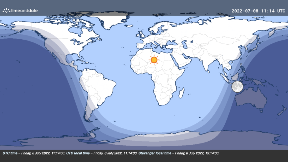
Our Day and Night World Map for July 8 at 11:15 UTC shows most of the world’s landmasses receiving sunlight.
©timeanddate.com


From Time&Date by Konstantin Bikos

A fascinating claim is circulating the internet: that there’s a moment each year when 99% of the world’s population gets sunlight.
Is it true?

It Happens yesterday on July 8 at 11:15 UTC

As July rolls around, our number crunchers thought it was worth fact-checking a July-related claim that has been making the rounds on the internet lately.

In the original post, Reddit user GiddySwine presents a still image of our Day and Night World Map, claiming that 99% of the world’s population is between dawn and dusk on July 8 at 11:15 UTC.

A more widely circulated version claims that 99% of the population gets daylight at that moment.

The Day and Night World Map uses different shadings for day, night, and the three stages of twilight:The lightest shading represents daytime when the Sun is above the horizon.
The darkest shading is nighttimewhen the Sun is below the horizon, and there’s no twilight.
The shadings between day and night are the three stages of twilight when the Sun is below the horizon, but there’s still some indirect sunlight. 

Covers the World’s Most Populated Areas

A brief look at our Day and Night World Mapgives some initial support to the claims (see image above).
Nearly all of the world’s most populated areas receive some sunlight at the time in question.
Among them are North America, South America, Europe, Africa, and most of Asia.

Australia, New Zealand, parts of Southeast Asia, and Antarctica are the only larger landmasses on the night side of Earth.

7.7 Billion People Get Some Degree of Sunlight

When we run the detailed numbers through our computer, we also find some support for the claim.

Combining timeanddate’s Sun data with 2022 population data from the Center for International Earth Science Information Network at Columbia University, we found that it’s nighttime for just under 80 million people on July 8 at 11:15 UTC.

That leaves about 7.7 billion people—roughly 99% of us—on the side of the planet illuminated by the Sun.

Over 6.4 billion of them are in the daytime, while more than 1.2 billion people experience twilight.
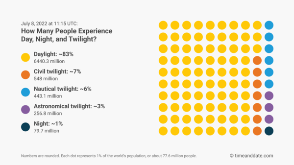
©timeanddate

So, with 83% of us getting direct sunlight and another 16% getting indirect sunlight, the claims are, in one way, correct.
And, before we go any further, let us say that this alone is a fascinating fact and a great find!

That said, there’s a hitch: a few hundred million people on the supposedly sunlit side of Earth will think it’s night.

Pitch-Black Twilight Sky

This is especially true for those who reside on the outermost edge of the twilight zones, within the darkest twilight phase called astronomical twilight.
Here, the Sun is 12-18 degrees below the horizon.
At that angle, the indirect sunlight becomes so thin that it is usually indiscernible to the naked eye.

The trace amounts of light in the otherwise pitch-black sky are of concern only in very particular contexts.
For example, it can hinder astronomers from observing the faintest celestial objects—hence the name of this twilight phase.


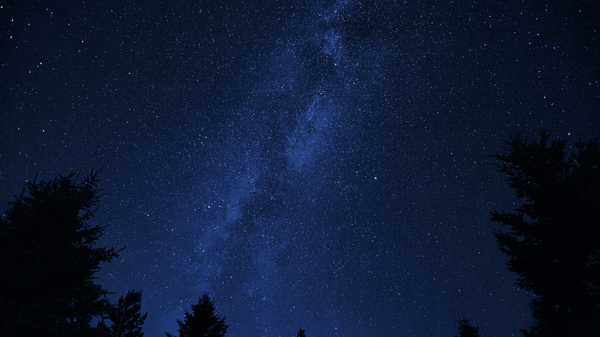
Astronomical twilight or nighttime?
When the Sun is 12-18 degrees below the horizon, the naked eye usually fails to discern the trace amounts of indirect sunlight in the sky.
©iStock.com/photographer3431
 
Hundreds of Millions Will Think It’s Night

So, 256.8 million people, about 3% of the world’s population, are so far behind the curve that no sunlight is visible.

Moreover, many people in the slightly brighter nautical twilight zone will fail to notice any daylight. Especially in urban areas, whose residents make up a majority of the total population numbers, light pollution can blend out the faint glow of the Sun, which is 6-12 degrees below the horizon at that point.

Claim Confirmed, But…

So, the claim is technically true if you count all twilight areas, no matter how dimly lit.

But the percentage of the population actually perceiving sunlight is a bit lower.
Discounting all of the people in the astronomical twilight zone and half of the population experiencing nautical twilight, we get 7204.9 million people, or about 93% of the world’s population.

It’s still a very high number. But the wording of the more recent versions of the post, claiming that 99% of the population will “experience daylight,” is somewhat misleading.

Why July 8 and Not the June Solstice?

When doing this fact check, one thing caught our attention: the date.

By far, most people reside in the Northern Hemisphere.
The June solstice, when the northern half of the globe receives the most sunlight, falls on or around June 21.
Doesn’t that mean even more people get sunlight on the day of the June solstice than on July 8?

Well, yes and no. As before, it depends on if you account for human perception or simply follow the technical definitions of the twilight phases.

July 8: Most People in Daytime or Twilight

Following the technical approach, July 8 is indeed a better date than June 21. As the Sun slowly makes its way south after the solstice, its rays gradually retreat from northern areas. However, at 11:15 UTC, this change affects only largely unpopulated areas, such as the northern Pacific Ocean.

At the same time, the Sun’s southward movement extends its reach farther south, for example, in Indonesia and the Philippines. Although the change is tiny in geographical terms, it covers some of the world’s most densely populated areasand adds about 10 million people to the twilight and daylight zones.

Comparing June 21 and July 8


June 21: More Visible Sunlight

Interestingly, while more people are on the night side of Earth at 11:15 UTC on the solstice than on July 8, the number of people experiencing civil twilight—the brightest twilight phase—is also considerably larger: 575.9 million people on June 21 and 548.0 million people on July 8.

So, of the people in the twilight zones, a larger percentage experience discernible twilight on June 21.

If we again discount the astronomical twilight zone and half of the nautical twilight zone, the total number of people actually noticing sunlight increases to 7218.8 million—nearly 14 million more than the 7204.9 million people doing so on July 8.

11:15 UTC Is the Perfect Moment


Whichever definition you use, the day-to-day difference is relatively small during this time of the year.

However, one fact remains undisputed: 11:15 UTC is indeed the perfect momenteach day when dawn begins on the North American west coast while dusk still reigns in East and Southeast Asia.

Get Ready for the Instant of Global Sunlight


If you want to mark the moment when most of humanity is bathed in sunlight, you can see the seconds tick down with our countdown.

And while you bask in the Sun, please spare a thought for our friends Down Under who are among the 1% experiencing actual nighttime at that moment—irrespectively of definitions and technicalities.


Friday, July 8, 2022

Europa island

 The small coralline island between Madagascar and Mozambique is a haven for nesting seabirds and green sea turtles.
 
From NASA 

Several volcanic seamounts and hundreds of volcanic cones rise above the floor of the southern Mozambique Channel.
A few of the larger volcanic features are capped with flat expanses of carbonate that breach the water’s surface, forming low-lying coralline islands.
Europa is one such island. 

Localization of Europa island in the GeoGarage platform (UKHO nautical raster map)
 
Europa Island is the focus of this image, acquired on April 3, 2022, with the Operational Land Imager-2 (OLI-2) on Landsat 9.

It is part of an overseas French territory that includes the Îles Éparses, or “scattered islands,” dispersed around Madagascar.
Mozambique on the African mainland lies about 500 kilometers (300 miles) to the west, and Madagascar sits about 300 kilometers (200 miles) to the east.
 
Europa island in the GeoGarage platform (SHOM nautical raster map)
 
Europa Island spans about 28 square kilometers, making it the largest of the Îles Éparses.
It was initially an atoll that became exposed at the sea surface around 90,000 years ago.
The atoll progressively filled in, and it slowly transformed into the island we know today.

A belt of nearly pristine coral reefs now hugs the coastline.
These “fringing” reefs span about 18 square kilometers, with a healthy coverage (80 percent) of live corals.
An abundance of fish, including sharks, cruise the reefs. 
 

Another important habitat—the Grand Lagoon—cuts far into the island. Saltwater mangroves dominate the lagoon’s shoreline, while a sandy beach covers its western side.
This beach, the lagoon, and the island’s shore all support each life stage of the island’s numerous sea turtles.
Europa has been called the largest nesting site for green turtles in the Western Indian Ocean.

Vegetation across much of the island likely has not changed much since naturalists started visiting in the early 20th century.
Dry forests still grow along the oldest and highest parts of the island, where the ground is rocky. Herbaceous plants and grasses spring from the newer surfaces that rise just a few centimeters above sea level, and bushes prefer the coastal areas.
The native vegetation provides critical breeding habitat for seabirds, including the red-tailed tropicbird, the red-footed booby, and the great and lesser frigatebird.

The most obvious evidence of human activity in these images are an airstrip, built in 1973 when a military camp was established, and the nearby sisal plantation planted by a family that attempted to settle on the island in the early 1900s.
Several attempts to settle on the island since 1860 have failed, possibly because of the lack of fresh water.
Today the only human presence is the French military and the occasional visiting scientist.

Thursday, July 7, 2022

What to do if you drop your smartphone in the ocean


From HowTOGeek by Ben J Edwards

You’re having a great day at the beach or on the ocean, but your fingers slip, and splash!
Down goes your smartphone into the briny deep—or hopefully, just into a few inches of salt water.
Either scenario can be devastating, so here’s what you should do.

First, Try to Find It

Unless you’re in a situation where it would be dangerous to retrieve the phone, you should try to locate your phone and get it out of the water as quickly as possible.
Here’s a few ideas: If you can’t see the phone, try to feel the phone underwater with your feet, or grab a fishing net and scoop up the sand until you find it.

If you can’t find the phone, you’ll probably need to consider it a total loss.
Contact your mobile phone carrier and tell them what happened, and ask them to assign your old phone number to a new device.
Using remote management tools like “Find My” in the Apple ecosystem, you can report your device as lost or stolen, deactivate it remotely, or remove it from your account.
If you have local or cloud backups (for Android or iPhone), you can use them to restore your data on a new device later. 
 

The iPhone 12 is water resistant. But just how much water can it actually take?
We dunked a brand-new iPhone 12 underwater in Lake Tahoe, California, to test out the IP68 rating and go even deeper than we've ever tested a phone before.

Turn It Off, Dry Phone as Much as You Can

Once your phone is out of the water, power it off completely.
Use a clean towel to dry the phone off as much as possible. If possible, remove the SIM card tray, any memory card trays, and the battery if it is not built into the phone.
If it’s in a case that is not waterproof, remove the case as well.

If your smartphone is already in a waterproof case or features water resistance and wasn’t in the water for very long, turn the phone off and rinse the phone (in the waterproof case, if it has one) under clean fresh water (not salt water.)
Dry it off with a towel, then let it sit for several hours to dry off before attempting to use it again.
If all works well, then you should be good to go.

If your phone isn’t water resistant, you may have heard that placing your smartphone in rice will help dry it out, but that’s just a myth.
Rice will do nothing, and leaving it sitting there will give the saltwater stuck inside the phone body extra time to corrode the electronics.
If you ever want to use the phone again, you’re in a race against time to disassemble the phone and clean it out before corrosion permanently damages the internal circuitry.

If Possible, Take the Phone Apart

If you feel qualified and capable to disassemble your phone, use the proper tools to open it up as quickly as possible.
iFixit publishes free guides that include detailed steps on how to disassemble many popular smartphone models.

Once the phone is open, rinse out the inside thoroughly with distilled water, gently brush away any corrosion with a soft brush, then let the phone sit in a bath of 90% rubbing alcohol for an hour, swishing it around a bit to displace any trapped water.
After that, let all the parts air dry for at least 24 hours, then re-assemble them and see if the device works. If it works, you’re probably all set.
Back up the device while it is still working in case there is a failure again from uncorrected water damage.

Otherwise, Take it to a Professional


Obviously, the disassembly steps above require a certain level of technical know-how and also the tools and parts to safely open a modern smartphone without damage.
So if you’re not comfortable with taking your phone apart, take it as soon as possible to a qualified smartphone repair shop.
Tell them you dropped your phone in salt water, and they should know what to do.
The phone will need immediate disassembly and deep cleaning inside and out if you want to save it.

If they aren’t willing to work on it right away and the phone is very important, take the phone somewhere else.
If you have an iPhone, you could consider getting an appointment at an Apple store, for example

Links :

Wednesday, July 6, 2022

Plastic pollution: Green light for 'historic' treaty

Getty Images

From BBC by Helen Briggs
 
An international committee will look at options for reducing plastic pollution
The world is set to get a global treaty to tackle plastic pollution.
 
Nearly 200 countries have agreed to start negotiations on an international agreement to take action on the "plastic crisis".

UN members are tasked with developing an over-arching framework for reducing plastic waste across the world.
There is growing concern that discarded plastic is destroying habitats, harming wildlife and contaminating the food chain.

Supporters describe the move as one of the world's most ambitious environmental actions since the 1989 Montreal Protocol, which phased out ozone-depleting substances.
They say just as climate change has the Paris Agreement, plastic should have its own binding treaty, which sets the world on course for reducing plastic waste.

Prof Steve Fletcher of the University of Portsmouth advises the United Nations Environment Programme (UNEP) on plastics issues.
He said the plastics problem spans international borders and boundaries.
"One country can't deal with plastic pollution alone, no matter how good its policies are," he said.
"We need a global agreement to enable us to deal with the widespread challenges that plastic gives us as a society."

What does this mean?

UN member states have agreed to start international negotiations on drawing up a global plastics treaty that could set rules for production, use and disposal of plastics.
The decision was made at a meeting of the UN Environment Assembly in Nairobi.

Dr Jeanne d'Arc Mujawamariya, environment minister for Rwanda, which has been at the forefront of the proposals, said they were optimistic the negotiations would put in place a framework "to end plastic pollution".
Conservation charity WWF described the decision as one of the world's most ambitious environmental actions since the 1989 Montreal Protocol, which phased out ozone-depleting substances.
Addressing the full lifecycle of plastic products - production and use, as well as disposal - is key to turning off "the plastic tap", said senior policy advisor, Paula Chin.
"The next step is to make sure all signatories are ready to deliver on the promise of this ground-breaking agreement," she added.

What happens next?

World leaders have until 2024 to agree the plastic pollution treaty, including which elements will be legally binding and how the deal will be financed.
Environmental groups are calling for clear and strong global standards that incentivise nations to stick to common rules and regulations over plastics, while penalising harmful products and practices.

There will be pressure to help countries in the global south dealing with plastic problems created in the global north.
"There is debate about who pays and how do we make sure that countries in the global south have got the resources to deal with the plastic pollution crisis that they face," said Prof Fletcher.

The UK government, which supported the resolution, described the agreement as "truly historic".
"In the space of just one human lifetime, we have caused unimaginable damage to the global environment, choking every single part of the global ocean with plastic pollution," said Lord Zac Goldsmith, government minister for international environment.
"And although there is much to be done now to turn it into an ambitious and far-reaching treaty, we can now begin to close this ugly chapter. "


Plastic takes hundreds of years to degrade
Getty images

Facts on plastic:

It's thought more than five trillion pieces of plastic are in the world's oceans, which can take years to break down.
Each year, 400 million tonnes of plastic is produced and 40% of that is single-use - plastic only used once before it's thrown away

More than eight million tonnes of plastic enters the world's oceans each year and most of that escapes from land
Not all plastic can be recycled, either because of the way it's made or because it's too expensive or difficult to do so

Animals on land or at sea can be harmed by plastic.
They can get trapped in carrier bags or food packaging or mistake plastic for food.
 
Links :

Tuesday, July 5, 2022

The implications of a possible sunken continent in the North-east Atlantic

 
Bathymetric map of the NE Atlantic Ocean.
Magenta line—boundary of continental crust; magenta—Icelandia; magenta + beige— Greater Icelandia; GIR—Greenland-Iceland Ridge; IFR—Iceland-Faroe Ridge; JMMC—Jan Mayen microplate complex; WTR—Wyville-Thompson Ridge; FR—Fugløy Ridge; GBB—George Bligh Bank; LB—Lousy Bank; BBB—Bill Bailey’s Bank; FB—Faroe Bank; RB—Rosemary Bank.
(Base map: Google Earth)

From Hydro


Is Iceland the tip of a vast, sunken continent?
A new theory could revolutionize geological thinking.
Academics believe that they have identified a remarkable geological secret: a sunken continent hidden under Iceland and the surrounding ocean, which they have dubbed ‘Icelandia’.

STRM bathymetry in the GeoGarage platform
 
An international team of geologists, led by Gillian Foulger, Emeritus Professor of Geophysics in the Department of Earth Sciences at Durham University (UK), believes the sunken continent could stretch from Greenland all the way to Europe.
Professor Foulger is a world-leading geologist whose research has contributed to mapping the geological composition of the seabed in relation to continental land masses.

It is believed to cover an area of ~ 600,000km2, but when adjoining areas west of Britain are included in a ‘Greater Icelandia’ the entire area could be ~ 1,000,000km2 in size.
If proven, it means that the giant supercontinent of Pangaea, which is thought to have broken up over 50 million years ago, has in fact not fully done so.

New Source of Materials and Hydrocarbons

This new theory challenges long-held scientific ideas about the extent of oceanic and continental crust in the North Atlantic region and how volcanic islands like Iceland formed.
The presence of continental, rather than oceanic, crust could also spark discussions about a new source of minerals and hydrocarbons, both of which are contained in continental crust.

The revolutionary new theory was born from an innovative series of expert meetings held in Durham (UK) and is included in a dedicated chapter of In the Footsteps of Warren B.
Hamilton: New Ideas in Earth Science published in June 2021 by the Geological Society of America, which Professor Foulger has co-written with Dr Laurent Gernigon of the Geological Survey of Norway and Professor Laurent Geoffroy of the Ocean Geosciences Laboratory, University of Brest (France).

Redrawing the Maps of Our Oceans and Seas


Speaking about the new theory, Professor Foulger said: “Until now, Iceland has puzzled geologists, as existing theories that it is built of, and surrounded by, oceanic crust are not supported by multiple geological data.
For example, the crust under Iceland is over 40km thick – seven times thicker than normal oceanic crust.
This simply could not be explained.
“However, when we considered the possibility that this thick crust is continental, our data suddenly all made sense.
This led us immediately to realize that the continental region was much bigger than Iceland itself – there is a hidden continent right there under the sea.”

“There is fantastic work to be done to prove the existence of Icelandia but it also opens up a completely new view of our geological understanding of the world.
Something similar could be happening at many more places.
We could eventually see maps of our oceans and seas being redrawn as our understanding of what lies beneath changes,” Professor Foulger concluded.

Bathymetric map of "Icelandia" in the North East Atlantic Ocean. 
Rights to the Non-living Resources of Adjacent Seabed

The research team is now working with collaborators from across the globe to test their theory.
This work could involve electrical conductivity surveys and the collection of zircon crystals in Iceland and elsewhere.
Other tests such as seismic profiling and drilling would need millions of pounds to fund, but such is the importance of this work that funding may well be forthcoming.

This work has important legal and political ramifications as, under certain conditions, the United Nations Convention on the Law of the Sea grants coastal states exclusive rights to the non-living resources of their adjacent seabed if scientists can prove that the seabed is a submerged extension of the continental landmass.

Professor Philip Steinberg, director of IBRU, Durham University’s Centre for Borders Research, noted: “Countries around the world are spending enormous resources conducting subsea geological research in order to identify their continental shelves and claim exclusive mineral rights there.

“Research like Professor Foulger’s, which forces us to rethink the relationship between seabed and continental geology, can have far-reaching implicatons for countries trying to determine what areas of the seabed are their exclusive preserve and what areas are to be governed by the International Seabed Authority as the ‘common heritage of humankind’.”

Monday, July 4, 2022

Why did two Antarctic Ice Shelves fail? Scientists say they now know.

Satellite images showed the Larsen B Ice Shelf splintering and collapsing from Jan. 31 to April 13, 2002.
Credit...NASA Earth Observatory

From NYTimes by Henry Fountain
 
The collapse of the two ice shelves was most likely triggered by vast plumes of warm air from the Pacific, researchers have found.
 

The rapid collapses of two ice shelves on the Antarctic Peninsula over the last quarter-century were most likely triggered by the arrival of huge plumes of warm, moisture-laden air that created extreme conditions and destabilized the ice, researchers said Thursday.

The disintegration of the Larsen A shelf in 1995 and of the Larsen B shelf in 2002 were preceded by landfall of these plumes, called atmospheric rivers, from the Pacific Ocean.
They generated extremely warm temperatures over several days that caused surface melting of the ice that led to fracturing, and reduced sea ice cover, allowing ocean swells to flex the ice shelves and further weaken them.

“We identify atmospheric rivers as a mechanism that can create extreme conditions over the ice shelves of the Antarctic Peninsula and potentially lead to their destabilization,” said Jonathan Wille, a climatologist and meteorologist at the Université Grenoble Alpes in France and the lead author of a study describing the research in the journal Communications Earth and Environment.

While there have been no collapses on the peninsula since 2002, Dr. Wille and his colleagues found that atmospheric rivers also triggered 13 of 21 large iceberg-calving events from 2000 to 2020.

Dr. Wille said the larger Larsen C shelf, which is still mostly intact and, at about 17,000 square miles, is the fourth-largest ice shelf in Antarctica, could eventually suffer the same fate as A and B.
“The only reason why melting has not been significant so far is because it’s just farther south compared to the others, therefore colder,” he said.
But as the world continues to warm, atmospheric rivers are expected to become more intense.
“The Larsen C will now be at risk from the same processes,” he said.


A rift in the Larsen C Ice Shelf in February 2017. Scientists say the C ice shelf could meet the same fate as A and B.
Credit...British Antarctic Survey, via Agence France-Presse — Getty Images

Kyle R. Clem, a researcher at Victoria University of Wellington in New Zealand who was not involved in the study, said the work also showed that other parts of Antarctica that are not warming as fast as the peninsula could eventually be susceptible as well, since the mechanism that the researchers documented is more dependent on warming where the atmospheric river originates.

“The amount of heat and moisture that atmospheric rivers transport is higher than it would be without global warming,” Dr. Clem said. 
“So the air mass that slams into Antarctica is much, much warmer. And it’s these episodes of extreme events that lead to ice shelf collapse.”
“You could get this anywhere in Antarctica,” he said.

Shelves are floating tongues of ice that serve to hold back most of the ice that covers Antarctica to depths up to nearly 3 miles.
When a shelf collapses, the flow of this land ice to the ocean accelerates, increasing the rate of sea level rise.

While the Antarctic Peninsula ice sheet is relatively small (if it all melted, seas would rise by less than a foot) the collapse of ice shelves elsewhere on the continent could lead to much greater sea level rise over centuries.

A mystery solved.
Researchers have established that the collapses of two ice shelves on the Antarctic Peninsula over the last quarter-century were most likely triggered by vast plumes of warm air from the Pacific.
As the world continues to warm, such plumes are expected to become more intense.

A prickly plant in danger.
A new study estimates that, by midcentury, global warming could put 60 percent of cactus species at greater risk of extinction.
Poaching, habitat destruction and other threats already make cactuses among the most endangered groups of organisms.

Thawing permafrost.
Climate scientists, policy experts and environmental justice advocates announced a $41 million project aimed at assessing the contribution of thawing permafrost to global warming. The project is financed by private donors, including the philanthropist MacKenzie Scott.

Hurricanes.
A new study found that climate change contributed significantly to the severity of the 2020 Atlantic hurricane season, the most active on record.
The most extreme three-hour rainfall rates were 10 percent higher than they would have been without climate change.

Methane emissions

Levels of methane in the atmosphere increased last year by the largest amount since measurements began four decades ago, according to analysis by the National Oceanic and Atmospheric Administration, adding to concerns about this planet-warming gas.

Last month, a small ice shelf collapsed in East Antarctica, which is considered the most stable part of the continent. In the days before, an intense atmospheric river arrived in the region.
It led to record high temperatures, but researchers are not yet certain how much of a role it played, if any, in the shelf’s disintegration.

Atmospheric rivers occur when a large stationary zone of high-pressure air meets a low-pressure storm system.
A narrow stream of moist air flows from the confluence of the two.

In a typical Southern Hemisphere summer, the peninsula gets from one to five of these events, the researchers said.
They looked at only the ones that contained the highest volume of water vapor.

If a river is intense enough, it can lead to several days of surface melting of the ice shelf.
As the meltwater flows into crevices it refreezes, expanding and widening the cracks.
Eventually such repeated hydrofracturing, as the process is called, can cause the ice shelf to disintegrate.

The atmospheric river can also spur the process by melting sea ice, or if its associated winds push the sea ice away from the shelf.
That allows ocean waves to rock the ice shelf, further stressing it.

Some large ice shelves in West Antarctica are thinning as a result of melting from underneath by warm ocean water. Catherine Walker, a glaciologist at the Woods Hole Oceanographic Institution in Massachusetts who was not involved in the study, said that regardless of the long-term trends of warming and thinning, “this paper brings up the important point that very brief weather events can push an ice shelf past its tipping point.”

Links :

Sunday, July 3, 2022

Frozen world

Experience our planet's natural beauty and examine how climate change impacts all living creatures in this ambitious documentary of spectacular scope.
In this episode: On the unforgiving frontier of climate change, polar bears, walruses, seals and penguins find their icy Edens in peril.