Saturday, December 21, 2019

News from America's Cup defender and challenger

Starfighter ops... foils locked in attack position for Defiant (America Magic)

How not to do it… (Team NZ)
Te Aihe had a slow speed capsize on the Auckland Harbour today.
When it goes over it’s best to get back on the horse (or dolphin) and back into testing.

Friday, December 20, 2019

Earth's magnetic North Pole has officially moved

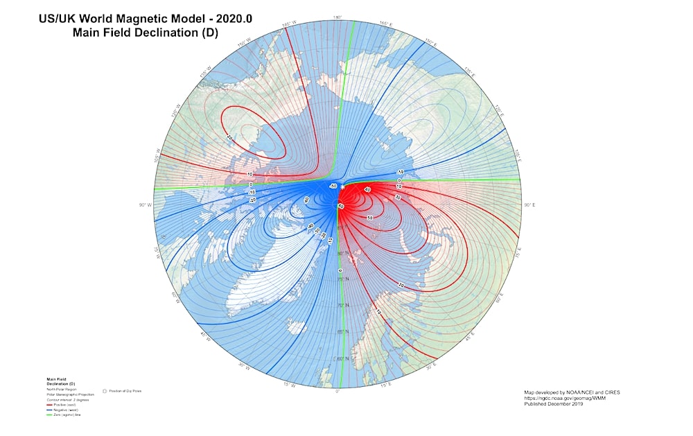
This map shows the new location of the magnetic North Pole (the white star).
NOAA NCEI/CIRES
From Forbes by Trevor Nace

Earth's magnetic North Pole has drifted so fast that authorities have had to officially redefine the location of the magnetic North Pole.
The extreme wandering of the North Pole caused increasing concerns over navigation, especially in high latitudes.

Earth's magnetic field is known to have wandered and flipped in the geologic past. Earth's magnetic field is a result of spinning molten iron and nickel 1,800 miles below the surface.
As the constant flow of molten metals in the outer core changes over time, it alters the external magnetic field.

What we've seen in the past hundred years is that the location of the magnetic North Pole has moved northward. That migration of the magnetic North Pole was switched into overdrive in the past few years, causing the pole to rapidly move. The increased speed with which the magnetic North Pole has moved prompted authorities to officially update its location. The official location of the magnetic poles is specified by the World Magnetic Model, which acts as the basis for navigation, communication, GPS, etc. around the globe.

The New Location Of Earth's Magnetic North Pole

On Monday, the World Magnetic Model updated their official location of the magnetic north.
The model is typically updated every five years and was last updated in 2015.
However, the recent rapid movement of the magnetic north prompted scientists to update the model early. In the recent past, the magnetic North Pole has moved 34 miles a year toward Russia.
Just a half-century ago, the magnetic North Pole was wandering about 7 miles each year.


Movement of Earth's magnetic pole over time
source : NOAA

Earth's magnetic North Pole is quickly moving from the Canadian Arctic toward Russia.
The model update ensures the accuracy of work in governmental agencies around the world.
Specifically, NASA, the Federal Aviation Administration (FAA) and the U.S. Forest Service use the magnetic poles in their daily operations from mapping to air traffic control.
On a more individual level, smartphones use the magnetic north for GPS location and compass apps.

Is Earth's Magnetic Field About To Flip?

While the rapid movement of Earth's magnetic North Pole may cause concern over the potential flip of magnetic poles, there is no evidence that such a flip is imminent.
Geologists can interpret magnetic minerals in rocks around the world to reveal the history of magnetic reversals on Earth.

Earth's magnetic poles have flipped many times in its history, with the latest reversal occurring 780,000 years ago and 183 times in the past 83 million years.
When Earth's magnetic poles do flip, it won't be a catastrophic "end of the world" scenario.
From examining fossil records, there is no evidence that a magnetic field reversal causes increased extinctions, volcanic activity, etc.

However, one big issue will lie in the extensive use our technology relies on the magnetic poles.
A reversal would upend navigation and communication systems around the globe.
Thankfully, a pole reversal in the past typically takes thousands of years to flip.
This will give us ample time to develop mitigating plans.
In reality, when Earth's magnetic field does flip, who knows what planet our descendants will be living on?

Links :

Thursday, December 19, 2019

Ancient seawall shows how ancestors tried to cope with rising seas


This village fought sea-level rise 7,000 years ago.
The sea won.

From Reuters by Rami Amichay and Ari Rabinovitch, with additional reporting by Matthew Green


An ancient seawall erected thousands of years ago along the Mediterranean coast at the end of an ice age is the oldest evidence of civilization trying to defend itself against rising sea levels, a team of researchers said on Wednesday.

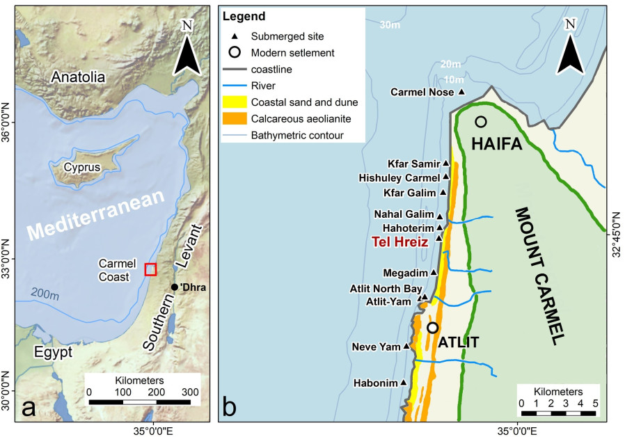
The 100-meter (yard) wall, built 7,000 years ago out of boulders in what is now northern Israel, was an early attempt by villagers to fend off the perils of a changing climate.


In this case it was in vain.
The Neolithic village was long ago overtaken by the sea as it swelled from glacial melting at the end of the last ice age.
Today the shoreline is much higher and the research was conducted under water.

A map showing the location of the defense wall in Tel Hreiz.
(photo credit: Flinders University)
 
 geolocalization with the GeoGarage platform (NGA nautical raster charts)

All that remains of the wall are some of the boulders, brought by ancient settlers from a riverbed more than a kilometer away, lining the seabed in a pattern that would fit a coastal defense.
“The environmental changes would have been noticeable to people during the lifetime of a settlement across several centuries,” said marine archaeologist Ehud Galili of the University of Haifa.
“Eventually, the accumulating yearly sea level necessitated a human response involving the construction of a coastal protection wall similar to what we’re seeing around the world now,” he said.

The Israeli coast has been populated by a myriad of civilizations over the millennia, many of whose remains are now under water. Marine archaeologists have uncovered countless treasures, including shipwrecks, harbors and dwellings.

The work was conducted by researchers from the University of Haifa, Flinders University in Australia, the Israel Antiquities Authority and the Hebrew University.
It was published in the journal PLOS ONE.

A rocky sea wall meant to protect an ancient farming village now lies drowned off the coast of Israel. E. Galili & J. McCarthy

According to the researchers, sea levels were rising faster when the Neolithic village existed around the end of the Stone Age, up to 7 millimeters a year, than they have so far under contemporary climate change.
“This rate of sea-level rise means the frequency of destructive storms damaging the village would have risen significantly,” said Galili.

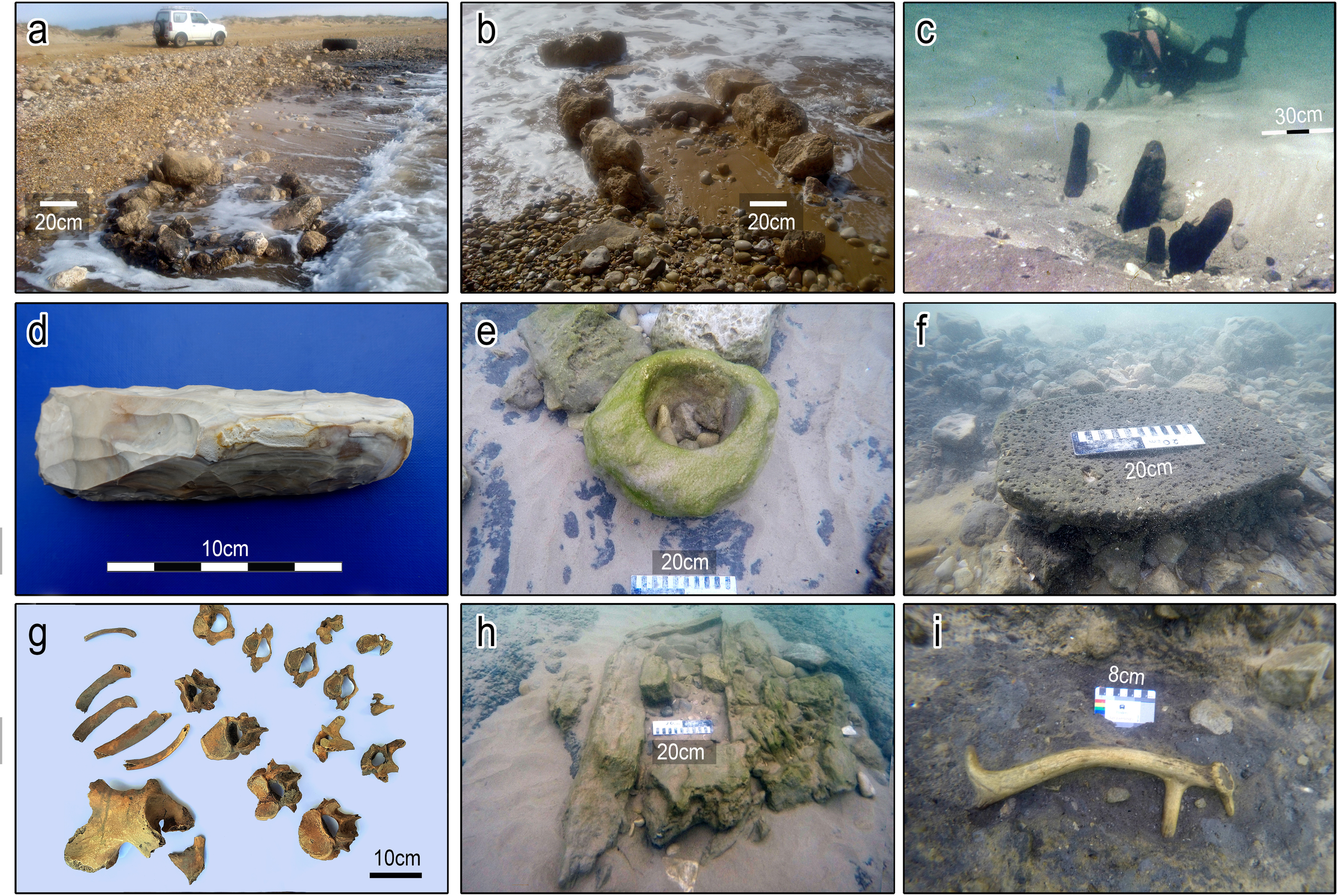
 Artifacts from Tel Hreiz. and (B) Stone features in shallow water. (C) Wood posts dug into the seabed. (D) A stone blade. (E) A bowl made of sandstone. (F) A basalt grounding stone. (G) Burial remains. (H) A stone grave. (I) An antler of Mesopotamian fallow deer. (E. Galili/V. Eshed) (Artifacts from Tel Hreiz. A and B Stone features in shallow water. C Wood posts dug into the seabed. D A stone blade. E A bowl made of sandstone. F A basalt grounding stone. G Burial remains. H A stone grave. I An antler of Mesopotamian fallow deer. E. Galili/V. Eshed)

Climate experts say sea levels are rising around 3 millimeters per year now, and the rate is accelerating as global warming caused by the burning of fossil fuels causes seas to expand and ice sheets to melt.

A landmark report on oceans by the U.N.-backed Intergovernmental Panel on Climate Change found in September that sea levels could rise by one meter (3.3 feet) by 2100 - 10 times the rate in the 20th century - if greenhouse gas emissions keep climbing.
The rise could exceed five meters by 2300.

Links :

Wednesday, December 18, 2019

World Magnetic Model 2020

The World Magnetic Model 2020 (WMM2020) was released December 2019 and can be downloaded.
The file contains the necessary coefficients to upload into systems that require the update.
A full report with more information about the WMM and this update will be published by NOAA's National Center for Environmental Information on their website in early 2020.
The WMM is a joint product of the United States' National Geospatial-Intelligence Agency and the United Kingdom's Defence Geographic Centre developed jointly by the National Centers for Environmental Information and the British Geological Survey.
The WMM is the standard model used by DoD, NATO, and IHO for a wide range of positional and navigation systems. WMM2020 is valid from December 10, 2019 through December 31, 2024.

From NGA

The National Geospatial-Intelligence Agency, in partnership with the National Oceanic and Atmospheric Administration and the British Geological Survey, released the World Magnetic Model 2020 update Dec.10, providing more precise navigational data for all military and civilian planes, ships, submarines and GPS units.

“With the 2020 update to the WMM, we’ve provided significantly better guidance to navigators regarding blackout zones so they know where they can trust their compass and where they should not,” said Mike Paniccia, a geodetic earth scientist and NGA’s WMM program manager.


A compass becomes increasingly unreliable as it gets closer to Earth’s magnetic poles, so NGA has released a new set of blackout zones to aid navigators near the poles.
NGA included shape files of these small regions near the Poles in the WMM 2020 release, so the information can be automatically loaded into navigational systems.
“The Earth’s magnetic field lines become vertical as you approach the poles, so if you were to stand on the magnetic north pole, your compass needle would be trying to break out of your compass and point vertically,” said Paniccia.
“Where this vertical intensity starts to overwhelm the horizontal intensity is where we have drawn the new blackout zones. This gives navigators a clear picture of where on Earth it is safe to trust a compass.”

A compass becomes increasingly unreliable when navigating closer to Earth’s magnetic poles?
The 2020 WMM update displays blackout zones to aid navigators as they near the poles, which can be automatically loaded into navigational systems, providing more precise navigational data for all military and civilian planes, ships, submarines and GPS units.

The WMM is necessary because the Earth’s geographic and magnetic poles do not align, so geomagnetic models like the WMM correct for this difference.

As the Earth’s magnetic field is constantly changing, the difference between geographic and magnetic north also changes, requiring the WMM to be updated every years or as necessary.
If you use GPS to navigate or have ever flown on an airplane, you’re reliant on the World Magnetic Model, said Paniccia.​

1840    

Canada (CHS) layer update in the GeoGarage platform

60 nautical raster charts updated & 2 charts replaced

Shipping industry sails into unknown with new pollution rules

A bird's-eye view of ships along the coast in Singapore July 9, 2017.
Reuters/Jorge Silva

From Reuters by Jonathan Saul

Faced with imminent new global marine pollution rules, shipping companies and insurers are puzzling over the risks.

To reduce emissions of toxic sulphur that cause premature deaths, shipowners who have long relied on the dirtiest residues of oil extraction will have to either switch to low-sulphur fuel or install exhaust gas cleaning systems from Jan. 1.

Neither option has been fully tested for long, and some problems have already been reported, both with the more expensive new fuels and with devices known as scrubbers which extract the sulphur on board.

Interviews with key players in the industry show varying levels of alarm at potential risks, which they say range from unexpected fires or collisions due to engine failure to liability for inadvertently flouting the rules.

The container shipping industry alone is having to invest $10 billion to adhere to the new rules, analysts say, and is concerned about extra costs were things to go wrong.

If different types of the new, cleaner fuel are mixed, for example, they may produce a residue which could eventually clog up an engine and, in a worst-case scenario, damage or break it.

Several large ship owners said handling the new fuels correctly and making sure the scrubbers were properly deployed would minimize danger, but that if care was not taken, problems could arise.

“The big guys are going to be serviced by the right people … there is bigger risk for the smaller ships,” Hugo De Stoop, chief executive of leading Belgian tanker operator Euronav (EUAV.BR), told Reuters.

Euronav has bought the equivalent of almost six months’ supply of compliant fuel and is storing it in a megatanker off Malaysia.
If a ship is too far away and has to buy fuel, it will try to buy a single type, or, if only a blend is available, ask to see the seller’s lab tests.

“We don’t always believe that people have done the test, been diligent about it,” he said.


Future proofing

Khalid Hashim, managing director of one of Thailand’s largest dry cargo ship owners, Precious Shipping (PSL.BK), said it had not allowed co-mingling of marine fuel, also known as bunker fuel, for over five years and required all of it to be sample tested.
“Of course this costs us annually around $100,000, but we prefer that cost than to use untested bunker oil based solely on the Bunker Delivery Receipt and find that we have a massive problem on our ship,” he said.
The company had taken measures to reduce its ships’ fuel consumption to offset some of the extra costs and had installed extra compartments for the tanks on board to avoid mixing, he said.

A view shows shipping vessels in the southern coast of Singapore March 2, 2017.
Reuters/Edgar Su/File Photo

“That way we would have future-proofed our ships for the IMO 2020 regime,” Hashim said, referring the U.N.
International Maritime Organization’s rules, agreed by more than 90 countries in hopes of saving more than half a million lives by 2025 alone.

Around 172 ships have avoided the problem because they are powered by sulphur-free liquefied natural gas (LNG), data from Norwegian risk management and certification company DNV GL showed, but this in an expensive option.

Some ship owners have balked at paying for the new 0.5% sulphur fuel, which is quoted at more than twice the price of the 3.5% high-sulphur grade in northern Europe at the moment.

More than 3,000 ships - around 5% of the global fleet - will have scrubbers fitted by 2020 so they can clean the exhaust gas and so continue using existing fuel, the DNV GL data showed.

Some ports have banned one type of scrubber, the open-loop version which empties washwater residues into the sea, and insurers have reported cases of fires or corrosion with the devices.

Norwegian ship insurer Gard cited a few cases where sparks from welding or cutting fell into a scrubber through uncovered openings: in one case it spread to the engine room through glass reinforced epoxy piping.

If corrosion was legally deemed to be inevitable, underwriters might try to deny related claims, said Stephen Harris, senior vice president with insurance broker Marsh.
“Whether underwriters adopt this line or not could depend on how frequent and how big the problem becomes next year.”

Roger Strevens, VP of global sustainability with Norwegian shipping company Wallenius Wilhelmsen (WALWIL.OL), said its experience with scrubbers had shown risks could be minimized if done properly.
“If you buy cheap, you’ll pay twice,” he said.

Crew safety

Nautilus International, a union which represents over 20,000 workers in shipping, said the use of new fuel types would place extra strain on crews, who have reported incidents including power loss when changing fuels, filter problems and leaks.
“These are complex requirements,” Nautilus professional and technical officer David Appleton said, calling for comprehensive training and protection in cases of inadvertent infringements.

An underlying problem is that oil refineries are not obliged to produce tailor-made shipping fuel, said Neil Roberts, head of marine underwriting at Lloyd’s Market Association, which represents the interests of all underwriting businesses in London’s Lloyd’s insurance market.
“The ship’s crew has to test it and filter it,” he said.

 Image credits: imo.org

The IMO said it does not have a remit to regulate the fuel industry but that international standards for the new fuel and information about compatibility between types had been issued as part of comprehensive preparations.
“IMO is ready, and we are confident IMO member states and the shipping sector are ready for January 1,” an IMO spokesperson said.

Protection and Indemnity (P&I) clubs, through which groups of shipping companies cover injury and pollution claims, are in wait-and-see mode.

Alvin Forster, deputy director with North P&I club, cited possible engine failure in busy shipping lanes, while Precious Shipping’s Hashim said members investing in expensive low-sulphur fuel should not have to share the loss on any scrubber claims.

Harris from Marsh, a broker active in marine insurance including hull and machinery, said assessing cover was still guesswork: for instance, who should pay a fine for a ship using high-sulphur fuel because no alternative was available?
“Is it non-compliance?” he said.
“The question marks are bigger than the answers.”

Links :
Tuesday, December 17, 2019

Waters off California acidifying faster than rest of oceans, study shows

The microscopic shell of foraminifera, a single-celled organism, magnified 650 times its size by a scanning electron microscope.
Scientists studying sediment samples containing the tiny shells were able to determine the rate the oceans are acidifying.
Credit : NOAA

From The NYTimes by Kendra Pierre-Louis

California’s coastal waters are acidifying twice as fast as the rest of the oceans, a study published Monday shows.
And some of California’s most important seafood — including the spiny lobster, the market squid and the Dungeness crab — are becoming increasingly vulnerable.

Why are the oceans becoming more acidic and how does that threaten biodiversity?
Human activities produce excessive carbon dioxide and much of it is absorbed by the oceans, where it is converted to an acid.

The carbon dioxide emissions that contribute to the planet’s rapidly warming climate are also changing the chemistry of the world’s oceans, which have absorbed roughly 27 percent of the carbon dioxide emitted worldwide.

Ocean water is ordinarily slightly basic, or alkaline, but is becoming more acidic as it absorbs carbon dioxide.
This can harm marine life, especially shellfish, because they struggle to make their shells in acidic waters.

Emily Osborne, a scientist in the National Oceanic and Atmospheric Administration’s ocean acidification program, with her colleagues studied the fossil record of planktonic foraminifera — tiny simple organisms which, like shellfish, build their shells from calcium carbonate.
They have been around for millions of years, but each individual organism only lives for roughly a month.
“They are creating this super tight snapshot of what the ocean looks like for a month period of time,” said Dr. Osborne, a lead researcher on the study, published in Nature Geosciences.

California’s fisheries account for slightly more than 10 percent of the nation’s seafood production.

An earlier study compared the impact of carbon dioxide emissions on immature shellfish in waters with carbon dioxide at preindustrial levels versus water with carbon dioxide at levels with concentrations expected by 2100.
It found that the latter had shells that were “malformed and eroded.”

There are a few reasons shellfish struggle in a more acidic ocean.
The first involves calcium, which, in the form of calcium carbonate, is a building block that helps create their protective shells.
But in order to make calcium carbonate, shellfish need access to a kind of carbon known as carbonate ion.
As the oceans absorb more carbon dioxide, there is more carbon than ever — but more of it is bicarbonate, not carbonate ion.

“It’s a shift in what is usable by the organisms,” Dr. Osborne said.
“So that they have fewer of those building blocks that they can actually utilize.”

Another reason is that “it could also be that they make a shell that’s weaker or that can be more easily corroded by the ocean chemistry or even weaker so it can be more easily drilled or crushed by a predator,” said Gretchen Hofmann, a marine biologist at the University of California, Santa Barbara, who was not involved in this study.

By analyzing the shell weights of almost 2,000 fossil shells from over the past century the researchers found a 20 percent reduction in calcification among surface-dwelling foraminifera.

Foraminifera shells viewed under a microscope.
Credit...NOAA

“I could just watch the shells literally getting thinner as I moved up through the record and got closer to the present day,” Dr. Osborne said.

The ocean currents off California tend to recirculate colder, more acidic water from deeper in the ocean to the surface, a process known as upwelling.
As a result, California’s waters were already more acidic than many other areas of the oceans.
Climate change is exacerbating the effect, raising the question of how marine life will fare over the long term.

“We know that evolution works and every creature has some degree of plasticity in them,” Dr.
Hofmann said.
But, she added, “the environment is changing so fast that we’re probably outstripping the role that it can play.”

Links :

Monday, December 16, 2019

Norway (NHS) layer update in the GeoGarage platform

219 nautical raster charts updated & 2 new insets added

Anak Krakatau: Giant blocks of rock litter ocean floor

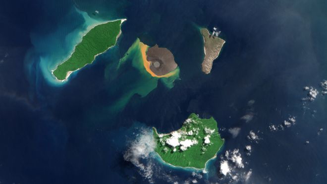
There are about 40 volcanoes worldwide thought capable of doing what Anak Krakatau (centre island) did
image : Copenicus data 2019

From BBC by Jonathan Amos

Shattered remnants from the volcano that generated a devastating tsunami in Indonesia a year ago have been pictured on the seafloor for the first time.

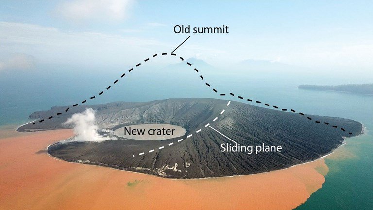
Scientists used sonar equipment to image the giant chunks of rock that slid into the ocean when one side of Anak Krakatau collapsed.
Some of these blocks are 70-90m high.
Their plunge into the water produced tall waves that tore across the shorelines of Java and Sumatra on 22 December 2018.


Over 400 people around the Sunda Strait died in the nighttime disaster, and thousands more were injured and/or displaced.

Dave Tappin recalls the event and describes the blocks of rock on the seabed

Researchers have been trying to reconstruct what happened ever since. But all their studies to date have been based on what can be seen above the water.

Prof Dave Tappin and colleagues realised they had to investigate the island volcano's missing mass - now under the ocean's surface - or they would never truly get a full description of Anak Krakatau's failure.
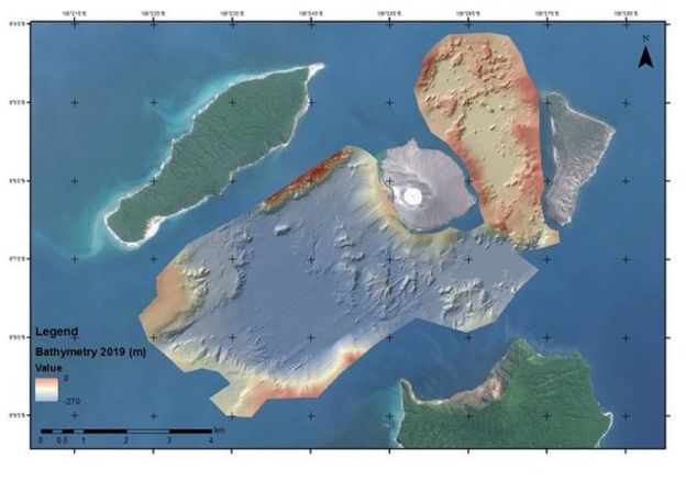
A multibeam echosounder was brought in to map the seabed.
Updated: This simulation shows how the volcano's flank slipped into the water

"Early models of the collapse were based on satellite imagery that only looked at the subaerial parts of the volcano," the British Geological Survey scientist told BBC News.
"Our bathymetry is imaging at 200m water depths and we are seeing triangular-shaped blocks, which are basically coherent and they formed, before the collapse, the southwestern flank of Anak Krakatau."

The debris field runs out to 2,000m from the volcano.
A seismic survey also conducted by the team shows how this material is layered on top of older deposits.
Crucially, the underwater imaging has allowed Prof Tappin's team to revise its estimate for the volume of rock involved in the flank failure.
And it's smaller than previously thought.
Calculations based on above-water measurements of what was left of the once 335m-high volcano had suggested a figure of 0.27 cubic km.
The new assessment now points to 0.19 cubic km sliding into the ocean, almost 200 million cubic metres.

Stephan Grilli: New simulations reproduce the damage observed on nearby islands

This smaller volume might have presented something of a problem for tsunami modellers.
Their original simulations of how the waves generated in the collapse moved across the Sunda Strait had already proved a good match for what had been observed at tide gauges and from what was known of the extent of damage along nearby coasts.

Now, the models are having to be re-run but with a smaller input.
The simulations still work, however - and with good reason.
Prof Tappin's team has also discovered that the failure plane on the volcano - the angle of slope along which the rock mass slid - was shallower than earlier assumptions.

Whereas it was once thought the failure plane cut down steeply into the basin created when the old volcano on the site blew its top in 1883, it's now obvious the collapse slope entered the water much nearer the surface.

This simulation, based on the new data, shows how the tsunami moved outwards

"We've already redone the near-field modelling with a finer resolution based on the new bathymetry and the results are about the same, despite having a smaller volume of rock," explained tsunami expert Prof Stephan Grilli from the University of Rhode Island.

"The shallower slide occurs almost like a ski jump, maintaining the collapse material closer to the surface and making it more tsunamigenic than a steeper failure, which would have brought the sediment down deeper, much quicker."

Profs Tappin and Grilli were speaking here in San Francisco at the American Geophysical Union's annual Fall Meeting.
This is the first chance they've had to present their findings to the wider scientific community.

Also speaking was Prof Hermann Fritz from the Georgia Institute of Technology.
He reviewed the damage on nearby shores, describing from on-the-ground studies how high the tsunami waves must have been and how far inland they reached.

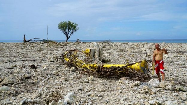
On the islands in the immediate vicinity of Anak Krakatau, trees up to 80m above the normal sea surface were torn from their roots.

Ujung Kulon National Park is due southwest of Anak Krakatau, some 50km away

Much of the wave energy took a path away from the volcano in the same direction of the collapse - to the southwest. This resulted in 10m-high waves laying waste to a corner of Ujung Kulon National Park on Panaitan Island - a distance of 50km from Anak Krakatau.

"Local residents were very fortunate that the collapse was in the southwest direction, in the direction where few people were living - towards the national park," said Prof Fritz.

"Had the collapse direction been different, the outcome could have been very different as well in terms of tsunami heights on populated areas."

Lessons learned from Anak Krakatau are being used to assess the hazards at other volcanoes. There are about 40 other locations around the world where flank collapse into surrounding water is considered a danger.

Anak Krakatau the child of Krakatau, will grow into an island by 1930 with the GeoGarage platform (NGA nautical raster chart)

The map shows the area covered by the bathymetric survey, to the southwest and northeast of Anak Krakatau

Links :

Sunday, December 15, 2019

Icebreaker crowd (1900s)

Opening shots from the award-winning Finnish film director and academic Kari Peter Conrad von Bagh (1943 –2014) documentary "Helsinki, ikuisesti" ("Helsinki Forever" 2008) show a crowd admiring (and soon being chased by) the icebreaker Tarmo in Helsinki, Finland.
Apparently filmed in the 1920s.
The film draws a portrait of Helsinki and also acts as an essay on Finnish culture in a wider sense.
The voiceover quoting Eino Leino towards the end is not related to this footage in particular.
It translates roughly as: "We do not live only in the present. The past – with all its memories, events and experiences – lives in us And often it just might so happen that the past is stronger than the present"

Russia's nuclear-powered icebreaker Arktika, said to be the world's biggest and most powerful, has returned to St. Petersburg after a two-day test run
Arktika, ordered by state nuclear company Rosatom and meant to transport liquefied natural gas from the Arctic, is 173 meters long and 15 meters high. 
The run tested the vessel's functioning and maneuverability, said Mustafa Kashka, general director of Atomflot, the company which runs Russia's icebreaking fleet. 
However, the nuclear-propelled ship, which can supposedly break through almost 3 meters of ice, was fueled by diesel oil on its maiden voyage. 
Inaugurated in 2016, Arktika is the first vessel in a project aimed at allowing year-round navigation in the Northeast Passage -- a sea route connecting the Atlantic and Pacific oceans traversing the Arctic following Russia's coast. 
The Arctic holds huge oil and natural-gas reserves that are being eyed by Russia and other countries, including the United States, Canada, and Norway. 
 The plan will also make it easier for Russia to deliver hydrocarbons to Southeast Asia. 
The final tests for Arktika are scheduled for March and April and it is set to start operating in May. Two other similar vessels -- the Ural and the Sibir -- are under construction. 

Links :