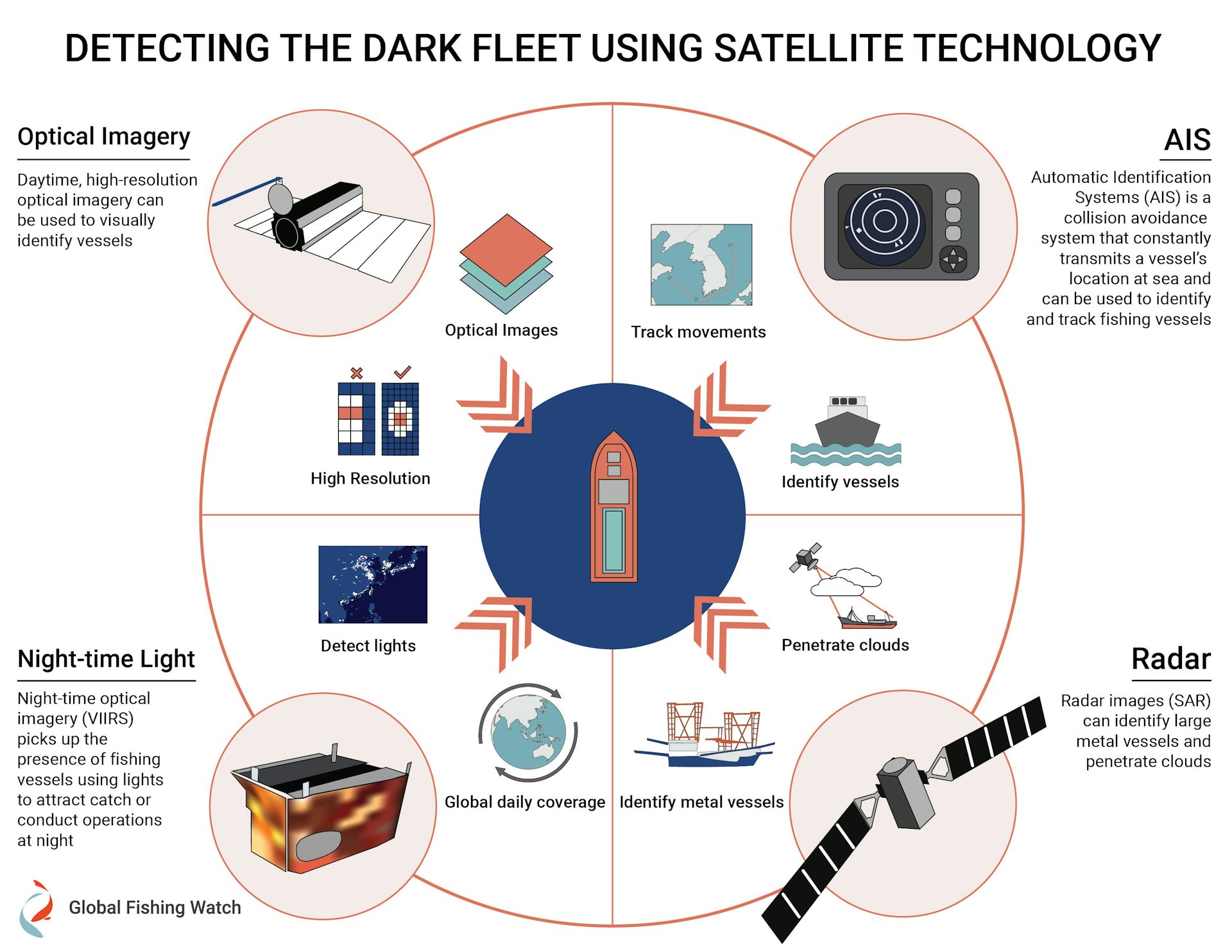
Saturday, July 25, 2020

Illuminating biodiversity of the Ningaloo Canyons

"Just Stunning" - sometimes the shortest description can carry the most weight.
The #NingalooCanyons expedition revealed amazing life in never-before-seen locations.
Join us for a look back at some of the most beautiful and intriguing views from ROV SuBastian.

Dr. Nerida Wilson, of the Western Australian Museum, and her team will bring ROV SuBastian to Cape Range and Cloates Canyons in order to identify and characterize the benthic biodiversity.
Very few deep sea areas both in and outside of Australia have been well-sampled over large spatial and temporal scales, and a large number of species still remain undiscovered and unnamed.
The team will complement ROV surveys using environmental genetics (eDNA), as well as expanding mapping in the region.

Major patterns of marine biodiversity appear to be strongly related to temperature, so exploring marine areas near known terrestrial hotspots offers an effective strategy for identifying undiscovered biodiversity.
In a country where there are little opportunities to explore the deep sea with a dedicated science ROV, this expedition will have a major impact in understanding this deep sea region. 

Friday, July 24, 2020

China's own records debunk 'historic rights' over disputed seas

A ruling at The Hague in 2016 tossed out Beijing's 'nine-dash line' claim in the South China Sea [File: Andy Wong/AP]

From Aljazeera by Ted Regencia

Experts say official Chinese documents belie 'nine-dash line' as Beijing asserts dominance in South China Sea.

Having secured an alliance with Philippine President Rodrigo Duterte during a state visit to Beijing in 2016, Chinese President Xi Jinping underlined it when he visited Manila in 2018, promising a new chapter in the two nations' diplomatic ties and vowing to turn the disputed South China Sea into "a sea of peace".

In a published message to Filipinos just before his trip, Xi recalled how, more than 600 years ago, Chinese explorer Zheng He "made multiple visits to the Manila Bay, Visayas and Sulu" areas during his "seven overseas voyages seeking friendship and cooperation".

The suggestion was that China had been in contact with the archipelago long before Europeans arrived and named it Las Islas Filipinas after Spain's King Felipe II.
It was also a way for Xi to bolster China's claims in the South China Sea - based on its "nine-dash line" and long contested by the Philippines, Vietnam, Malaysia, Brunei and Indonesia.

The problem is that the evidence suggests Zheng never set foot in the future Philippine islands.

"All the scholars all over the world are unanimous: Zheng He never visited the Philippines," Antonio Carpio said in an online lecture earlier this month, calling Xi's anecdote "totally false".
The former Philippine Supreme Court justice also presented official Chinese records that debunk Beijing's "historical maritime rights" over the South China Sea - thereby raising new questions about its standing in the region as tensions escalate.


South China Sea tensions prevail ahead of The Hague ruling (2:31)

On Monday, the US raised the stakes, saying "Beijing's claims to offshore resources" across most of the disputed seas were "completely unlawful".
US Secretary of State Mike Pompeo added that the world would "not allow Beijing to treat the South China Sea as its maritime empire." In response, Beijing accused Washington of unnecessarily inflaming the situation.

Earlier, the US deployed the warships USS Nimitz and USS Ronald Reagan to assert what it calls its freedom of navigation in the waters.
A sailor on one of the ships told Al Jazeera that the operations could last for weeks.
China held a large-scale naval exercise in the area from July 1 to 5.
'History vs facts on the ground'

Historical records may not favour China in the continuing debate on the control of the South China Sea, through which as much as $5.3 trillion in global trade passes annually.

Refuting the Chinese president's claim, Carpio presented evidence from China's own Naval Hydrographic Institute, chronicling Zheng's visit to the then-Cham Kingdom of central Vietnam.
A translation mixup of the kingdom's Chinese name incorrectly referred to it later as a Philippine island.

A 2019 Ancient History Encyclopedia article also traced Zheng's expeditions in the early 1400s as far as Arabia and Africa, but nowhere in the story did it mention Zheng's supposed visit to the Philippines.

A map of ancient China dating back to the Tang Dynasty shows that the island of Hainan was the country's southernmost territory
[State Bureau of Cultural Relics of China via the presentation of Philippine Justice Antonio Carpio]

To further disprove China's claim of "historical rights", Carpio presented several ancient Chinese maps, dating as far back as 900 years ago, to the Song and Tang dynasties.
All the maps showed that China's southernmost territory was the island of Hainan.

Additionally, the 1947 Constitution of the Republic of China, also identified Hainan as the country's southernmost part, raising questions over what would later emerge as the "nine-dash line" claim.

Regardless of the historical evidence, the reality is that China already "controls almost all the facts on the ground" and now has a "real and credible foothold" in the South China Sea, said Thomas Benjamin Daniel, senior foreign policy expert at Malaysia's Institute of Strategic and International Studies (ISIS Malaysia).

Still, Daniel and other analysts urge China and other stakeholders in the region to abide by the principles and spirit of international law, to keep the peace and avoid situations that would lead "down a very dangerous road."


#USNavy's Nimitz, Reagan Demonstrate Unmatched Commitment to #FreeAndOpenIndoPacific

DETIALS ⬇️ #ForceToBeReckonedWithhttps://t.co/S6gCikQrJppic.twitter.com/ZkU4WbNPVA— U.S.
Navy (@USNavy) July 8, 2020

'Nine-dash line'

For years, China has anchored its South China Sea claims on the "nine-dash line", under which it lays claim to almost 90 percent of the disputed waters as far south as the coasts of Malaysian Borneo and Brunei.
Images published by China showed the imaginary line almost hugging the shores of neighbouring countries.

Using the controversial line, Beijing has been ramping up activities in the South China Sea, starting with the Paracel Islands in the 1970s and 1980s, the Spratly Islands in the 1990s, and the Scarborough Shoal in the early 2000s.

Chester Cabalza, a security analyst and fellow at the National Defence University in Beijing, said China has been strategic in approaching the "South China Sea conundrum".
He added that the ongoing coronavirus pandemic has only provided the country even more opportunities to advance its interests.

"It seems like China is winning," he told Al Jazeera, noting how it had militarised the disputed waters by developing rocks and atolls into islands in recent years.

ISIS Malaysia's Daniel added that China "is playing the long game", as it attempts to solidify and "normalise" its regional maritime position.

An aerial view of the disputed Subi reef shows China's construction of maritime and aerial facilities on reclaimed land in 2017
[File: Francis R Malasig/EPA]

The Hague ruling

Beijing's approach encountered resistance in 2016 with the landmark ruling of the Permanent Court of Arbitration in The Hague, which declared that China's "historical rights" had no legal basis.

The ruling also said that the rocks and the partly submerged features on which China had built its naval and aerial facilities, were within the 200 nautical-mile (370.4km) Exclusive Economic Zone of the Philippines, as defined by the UN.
An EEZ is an area where only the country it belongs to can fish and explore natural resources, although safe passage is granted to foreign vessels.

The court also established the EEZs of Malaysia, Brunei, Indonesia and Vietnam, boosting their positions in relation to China.

Furthermore, the court said China's reclaimed areas and artificial islands were not entitled to a 12-nautical-mile (22.2km) territorial sea, because they were not habitable in their original form.
As such, freedom of navigation and overflight are allowed in those areas.

China refused to participate in the arbitration case, dismissing the ruling as "null and void".

COUNTING THE COST | South China Sea: Beijing extends its military and economic reach (26:01)


It has also continued to expand its facilities in the South China Sea, including a three-km (1.86-mile) military-grade runway, barracks and radars on Mischief Reef, which is within the Philippine EEZ.

Maritime incidents have also escalated, with a Vietnamese boat being sunk in April, an incident blamed on a Chinese surveillance vessel.
All eight fishermen survived.
In June 2019, at least 22 Filipino fishermen were left to drown when their fishing boat was rammed under suspicious circumstances by an alleged Chinese militia boat.
They were later rescued by Vietnamese fishermen.

On Tuesday, Malaysia revealed that Chinese coastguard and navy ships had encroached into its waters at least 89 times between 2016 and 2019.
Earlier this year, there were also reports of a Chinese government survey ship "tagging" a Malaysian oil-exploration vessel within the Malaysian EEZ.

Cabalza, of the National Defence University in Beijing, described China's behaviour as "schizophrenic", as it tries to employ both confrontation and cooperation in dealing with its neighbours.

'Code of Conduct'

As part of its effort to defuse tensions in the region, the Association of the Southeast Asian Nations (ASEAN) has been pressing China for years to reach agreement on the so-called Code of Conduct, which would govern countries' behaviour in the South China Sea.

Differences between members - some of whom have no claim to the sea but are close to China - mean there has been little headway made.

Cabalza says the 10-nation bloc must present a more unified voice before it takes on China, which prefers bilateral negotiation, adding that ASEAN nations "should not become submissive" in negotiating an equitable deal with Beijing.

On June 26, ASEAN leaders held a virtual summit hosted by Vietnam, in which they declared that the 1982 United Nations oceans treaty should be the foundation for sovereign rights and entitlements in the South China Sea.
However, the leaders were unable to make significant progress on the Code of Conduct.

As the current chairman of the 10-nation ASEAN bloc, Vietnam has stepped up its pushback against Beijing amid recent incidents of alleged harassment of civilian vessels in the South China Sea
[File: Hau Dinh/AP]

Daniel says he is "not very optimistic" that an agreement can be reached soon to help ease tension.

"ASEAN is an association of 10 member states with different national and foreign priorities, that makes decisions based on consensus.
Consensus here often means the lowest common denominator."

In the absence of a consensus, the increased presence of the US in the South China Sea could prove a useful counterweight.

Daniel said the "marked increase" of US freedom of navigation operations and sharper rhetoric, show that Washington wants to remain relevant in the region.

On Wednesday, Pompeo issued another statement saying the US would "support countries all across the world who recognise that China has violated their legal territorial claims as well - or maritime claims as well."

Meanwhile, Carpio said the world's navies should be encouraged to sail through the South China Sea and exercise freedom of navigation - to deliver a message to Beijing that it does not control the area.

He also urged Malaysia, Brunei, Indonesia and Vietnam to help the Philippines in explaining that China's claim of "historical right" is "totally false."
"We should continue resorting to the rule of law, because we have no other choice," Carpio said.
"War is not an option."

Links :

Thursday, July 23, 2020

Chinese fishing boats took half a billion dollars of illegal squid from North Korea. Scientists used satellites to catch them out

A new study revealing widespread illegal fishing in North Korean waters.
Individual technologies have distinct limitations, but when combined, can provide an informative picture of fishing activity.
Global Fishing Watch partnered to use four types of technology (AIS, SAR, VIIIRS & high-resolution optical imagery) to reveal widespread illegal fishing
@ORBCOMM_Inc, @SpireGlobal, @KSAT_Kongsberg, @planetlabs, @esa, @JAXA_en, @NOAASatellites @globalfishingwatch

From The Conversation by Quentin Hanich & Katherine Seto
Quentin Hanich receives research funding from Global Fishing Watch, and is a research partner with the Japanese Fisheries Research and Education Agency, and Global Fishing Watch.
Katherine Seto is a Global Fishing Watch research partner and an affiliate of the Australia National Centre of Ocean Resources and Security (ANCORS).

A “dark fleet” of hundreds of Chinese fishing vessels has illegally caught more than half a billion dollars worth of squid in North Korean waters since 2017, according to new research that used satellite technology, on-water observations and machine learning to track the unreported vessels.
The illegal catch may have driven small North Korean fishing boats into dangerous waters and contributed to the sharp decline of the Japanese flying squid.

In some parts of the ocean, fishing occurs in the shadows, with illegal activity widespread. Most vessels fishing illegally don’t broadcast their movements and are invisible to public surveillance systems.
They are known as the dark fleet.
Groundbreaking analysis from Global Fishing Watch and research partners has revealed widespread illegal fishing by dark fleets operating in the waters between the Koreas, Japan and Russia, some of the world’s most disputed and poorly-monitored waters.
Through an unprecedented use of multiple satellite technologies and machine learning, the researchers uncovered the largest known case of illegal fishing perpetrated by a single industrial fleet operating in another nation’s waters.
The analysis, published in Science Advances, marks the beginning of a new era in satellite monitoring of global fishing activity and reinforces the importance of greater transparency to fight illegal fishing.

A global problem

Illegal, unreported, and unregulated fishing is a global problem.
It threatens fish stocks, marine ecosystems, and the livelihoods and food security of legitimate fishing communities worldwide.
This kind of fishing is hard for governments to address, as it is often carried out by “dark fleets” of vessels that do not appear in public monitoring systems.

  A map of north-west Pacific fishing hotspots produced by Global Fishing Watch in 2018. Photograph: Global Fishing Watch

However, working with a team from Korea, Japan, Australia and the US, we’ve devised a new approach to tracking clandestine fishing.
We used it to identify more than 900 vessels originating from China that fished illegally in North Korean waters in 2017, and more than 700 in 2018.
The research is published today in Science Advances.

As Chinese vessels fish North Korean waters, North Korean boats move further north towards Russia.
Global Fishing Watch

Sanctions and ghost boats

Chinese vessels have historically fished the waters adjacent to North Korea.
However, in 2017 the UN Security Council adopted sanctions restricting North Korea’s fisheries and seafood trade in response to ballistic missile testing.
The sanctions also prohibited North Korea from selling or transferring fishing rights.

New satellite technology has the potential to be applied around the globe to illuminate fishing fleets and provide greater transparency into human activities across our ocean.
Global Fishing Watch and partners have used four satellite technologies to reveal widespread illegal fishing by dark fleets — vessels that do not publicly broadcast their location or appear in public monitoring systems — operating in the waters between the Koreas, Japan and Russia, some of the world’s most poorly-monitored waters. 
- Automatic identification systems (AIS) monitors the movements of the vessels that broadcast their positions. 
- Satellite radar identifies large metal vessels even under overcast skies. 
- Nighttime optical imagery picks up the presence of fishing vessels using lights to attract catch or conduct operations at night. 
- Optical imagery provides visual confirmation of vessel activity and type. 
Through this novel use of satellite data and machine learning, Global Fishing Watch and partners have uncovered the largest known case of illegal fishing perpetrated by a single industrial fleet operating in another nation’s waters.

Because of the sanctions, Chinese vessels fishing in North Korea after September 2017 would constitute a violation of either or both international and domestic law.
Nevertheless, the South Korean Coast Guard identified hundreds of vessels of Chinese origin passing through their waters en route to North Korean fishing grounds.

Additionally, the Chinese fishing activity has displaced smaller North Korean fishing boats, many of which have been driven into illegal fishing in neighbouring Russian waters.
These vessels lack the equipment or endurance for these distant and dangerous waters.
Japanese coastal communities have reported hundreds of such vessels drifting ashore as “ghost boats”, empty or carrying only human remains.

A pair trawler, a Chinese lighting vessel and a North Korean fishing boat.
East Sea Fisheries Management Service, South Korea / Seung-Ho Lee
Lighting up the dark fleet

Our multinational study was initiated at a technical workshop in 2018, co-hosted by the international non-profit organisation Global Fishing Watch, Japan’s Fisheries Research and Education Agency, and the Australian National Centre for Ocean Resources and Security (ANCORS) at the University of Wollongong.
The study was led by Jaeyoon Park from Global Fishing Watch and Jungsam Lee from the Korea Maritime Institute, and included scientists, engineers and policy experts from Korea, Japan, Australia and the US.

Together, the research team conducted an unprecedented synthesis of four satellite technologies, combining automatic identification system (AIS) data, optical imagery, infrared imagery, and satellite radar to create the most comprehensive picture of fishing activities in the area to date. 

Global Fishing Watch

The research team focused on the two most common types of fishing vessels active in the area: pair trawlers and lighting vessels.

Pair trawlers travel in teams of two, dragging a net between them, and can be identified in satellite imagery by their characteristic pairs.
The team used a machine learning approach called a convolutional neural network to pick out pair trawlers from high-resolution optical satellite imagery, verified with satellite radar and AIS data.

With these three technologies, the team estimated approximately 796 distinct pair trawlers operated in North Korean waters in 2017, and 588 in 2018, and traced these vessels back to Chinese ports.

Pair trawlers can be detected from satellite imagery.
Planet / Global Fishing Watch

Lighting vessels use bright lights to attract fish.
The Chinese vessels are uniquely bright, using as many as 700 incandescent bulbs which put out as much light as some football stadiums.

To track these lighting vessels, the research team used high-sensitivity infrared imagery cross-referenced with high-resolution optical imagery and satellite radar.
This analysis identified approximately 108 lighting vessels of Chinese origin operating in North Korean waters in 2017 and 130 in 2018.

These analyses allowed researchers to estimate that more than 900 distinct fishing vessels fished these waters in 2017, and more than 700 in 2018.
Automatic identification system (AIS) data show the origin of vessels fishing in North Korean waters.
Global Fishing Watch

We also identified low-intensity lighting vessels: the North Korean fleet of much smaller boats.
North Korean fishing vessels are typically wooden boats 10–20 metres long, using only 5 to 20 light bulbs.

We spotted about 3,000 North Korean vessels fishing in Russian waters during 2018.
While Russia historically licensed small numbers of North Korean boats, they stopped issuing permits in 2017, suggesting this activity is also likely in violation of fishing laws.

In recent weeks, the study team has undertaken a follow-up analysis to verify if the illegal fishing has continued in the interim since the paper was first submitted for peer review.
The analysis identified approximately 800 vessels from China fished in 2019 in North Korean waters, indicating that the illegal activity is ongoing.

Chinese and North Korean lighting vessels.
(A) A 55- to 60-m Chinese lighting vessel near North Korean waters.
(B) A Planet SkySat (0.72-m resolution) image of a Chinese lighting vessel.
(C) A 10- to 20-m wooden North Korean lighting vessel in the Russian EEZ.
(D) Vessel detections on 24 October 2017 by SAR, which detects large, metallic vessels but not smaller wooden ones [by PALSAR-2 (Phased Array L-band Synthetic Aperture Radar-2); blue box shows detection footprint, and blue dots show vessels]; and by VIIRS, 2 hours later, revealing lighting vessels with the brightest lights (red, >1000 nW/cm2/sr, mostly Chinese), with medium lights (orange, 50 to 1000 nW/cm2/sr, South Korean or Chinese), and the dimmest lights (yellow, <50 nW/cm2/sr, mostly North Korean). Vessels in (D) (i) are Chinese lighting vessels, (ii) Chinese pair trawlers (detected only by SAR), (iii) North Korean squid vessels (detected only by VIIRS), and (iv) the South Korean squid fleet.

A political and ecological problem

This massive operation poses substantial implications for fisheries governance and regional politics.
If the vessels are not approved by China and North Korea, they are fishing illegally in contravention of Chinese and/or North Korean domestic regulations.
On the other hand, if they are authorised by China or North Korea, it is a violation of UN sanctions and illegal under international law.

In addition, the fishing is a catastrophe for regional fish stocks.
The Japanese flying squid (Todarodes pacificus) is targeted by several fishing fleets and is a critical seafood for South Korea, North Korea and Japan.
The lack of cooperation and data-sharing prevents accurate stock assessments and sustainable management of a fishery that has already declined by approximately 80% since 2003.

Japanese flying squid are in sharp decline.
Global Fishing Watch

The study demonstrates the ongoing need for improved understanding of the often hidden dynamics that contribute to illegal, unreported and unregulated fishing.
Political barriers and conflicts often hinder international cooperation, data sharing and effective joint fisheries management.

 This video (data from Global Fishing Watch) shows a consolidated 1 year worldwide fishing effort of the Chinese fleet (all fisheries under China's flag).
About 15,000 ships as GFW papers have estimated, but if China's flags of convenience are included the number goes beyond 16,000.
The high seas have an urgent need of reaching an international fisheries resources management agreement.

Combining satellite technologies can reveal the activities of dark fleets, filling a major gap in the management of distant fisheries.
But to ensure safe, legal, and sustainable fishing, regional cooperation and a renewed focus on transparency and reporting are necessary.

 Bringing high tech to the high seas.

Links :

Wednesday, July 22, 2020

One woman, four men and weeks in Norway's Arctic ice

Barba

From CNN by by Terry Ward, photos by Daniel Hug, CNN


The summer before I turned 40 -- with my fertility ebbing, as everyone with a vested interest in such things felt the need to remind me -- I decided to set sail on the biggest adventure of my life.

Together with four men aboard a small sailboat named Barba, we cast off from southern Norway, bound for the remote Arctic archipelago of Svalbard on a four-month expedition that covered more than 4,500 miles.
A freelance travel writer and experienced scuba diver who grapples with seasickness, I've traveled the world mostly on land.
I'd been sailing offshore in something other than a cruise ship only once, during a training trip to the Faroe Islands from Norway aboard Barba.
And I'd perhaps oversold my cooking skills as a way to get back onboard for this more serious adventure (officially, I was the expedition's chef).

The truth is, I was looking for adventure.
And I was hardly the only one.

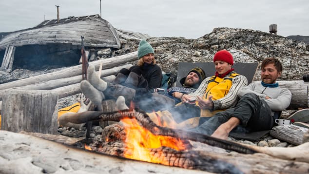
Writer Terry Ward, left, with crew members Jon Grantangen, Andreas B.
Heide and Ivan Kutasov.
@terragraphy/Daniel Hug 

Our crew of five hailed from Norway, Russia, the United States and Germany (I was the only woman and the lone American onboard).
The captain was Andreas B. Heide -- an experienced sailor and marine biologist I'd met years before through the Couchsurfing website.
He free dives with orcas in the Norwegian winter, scorning tropical destinations to sail to places such as Iceland and Greenland instead.

Related contentThe world's most extreme odysseys
Daniel Hug, an outdoor adventurer and mountaineer from Germany who'd worked as an avalanche observer as well as a part-time hair model, was our onboard cameraman.

We met Ivan Kutasov, the Russian, thanks to a serendipitous Instagram post of him surrounded by ice in a plywood sailboat in the Russian Arctic.
And Jon Grantangen was a mild-mannered Norwegian and ex-military marksman who'd already been to the Arctic aboard Barba (and had once walked the entire length of Norway, just for the heck of it).

We were a cast of characters that seemed perhaps more fit for a reality TV show than an Arctic expedition to a place with more polar bears than people.
And I wondered how being the only woman aboard would play out.

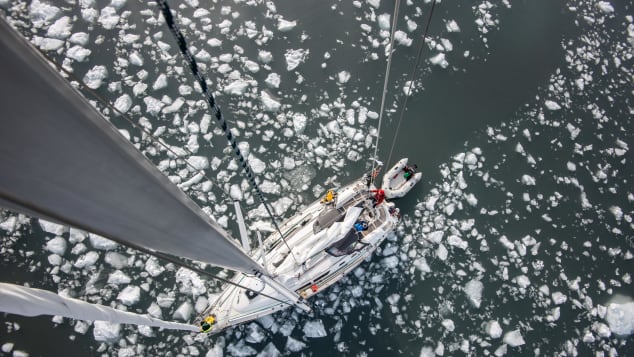
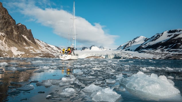
The crew of five lived aboard Barba for four months, sailing to Svalbard and back.
@terragraphy/Daniel Hug

An expedition laced with angst and adventure
Our floating home, Barba, was Heide's 37-foot Jeanneau sailboat made of fiberglass, technically better suited for snorkeling outings in the Mediterranean than picking her way through the pack ice in the polar regions, as we eventually would.

As the saying goes, though, the best boat is the one you have.
And Heide had tricked out Barba to the max with all manner of safety gear -- including radar, a forward-looking sonar to scan for ice and a dinghy for getting ashore and exploring tighter spots -- so she was as seaworthy as possible for our journey to Svalbard and back.
Related contentThe Arctic explorers locked down in a tiny hut in Norway's Svalbard archipelago
Inside, the boat was the size of a small college dorm room, with three cabins for sleeping, a galley and a lounge, where we all sprawled amoeba-like, occupying every square inch to read, eat and scour the nautical charts.
In an effort to improve Russian-American relations, it was decided that Kutasov and I would room together.
And it worked out well, as he and I amassed a collection of driftwood, reindeer antlers, sea glass and other Arctic detritus that wouldn't have flown inside the tidier German and Norwegian cabins.

Some but not all of us had partners waiting for us back home, and the satellite phone came in handy for staying connected when we were offshore.
My boyfriend at the time, from France, had sent me off with his full support, never wanting me to miss an adventure.
(In the back of my mind, however, I knew we both needed a break).

Captain Andreas B.
Heide, right, with Jon Grantangen aboard Barba.
@terragraphy/Daniel Hug

That's not to say there weren't romantic adventures off the boat in Norwegian ports en route, although never between the crew (and what happens on and off a sailboat stays there, as any sailor knows).

We carried plenty of gear with us for adventures of the outdoor variety, too, including a compressor for filling scuba tanks for diving under the ice and paragliders for two of the crew, who once soared above a polar bear hunting for bird eggs on a cliff.

Visitors to Svalbard are required to travel with heavy duty rifles outside of the main settlement in Longyearbyen because of the presence of polar bears.
And while we never had to fire a flare gun or a real gun to scare off a bear, they were the most vital tool in our kit for going on land (only two of our crew, the Norwegians, were licensed to shoot).

@David Gonzalez

For me, the reason for embarking on a trip like this was pretty simple -- I felt like I had nothing to lose and everything to gain at a time in my life when I needed something to push me out of my comfort zone as a travel writer accustomed to luxury trips with little effort required.

I wanted to get back to my true traveler roots, and setting sail with a bunch of men -- most from countries where women and men are pretty egalitarian -- seemed like a good way to do it.

I had personal angst driving me, too.
It took me almost 40 years to get there, but I finally reached the point where I knew I wanted kids.
I just wasn't sure if I was in the right relationship to have them.

Setting off with four adventurous guys into the Arctic ice seemed like a good way to put off making any decisions a little longer while enjoying life to the max and seeing what might drop into my lap.

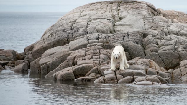
The archipelago of Svalbard is home to more than 3,000 polar bears.
@terragraphy/Daniel Hug

Where bears outnumber people

Svalbard is a glacier-covered archipelago roughly 600 nautical miles off the northern coast of Norway that's considered Europe's last true wilderness.
It's home to roughly 2,600 people, including a slew of scientists and over 3,000 polar bears.

Once we left the comforts of the cozy villages along the Norwegian mainland, the three-day crossing to Svalbard's southern tip gave us time to think about the wilderness that was waiting.

Each of us took turns "on watch," steering the boat and manning the sails to navigate during two-hour-long stints that continued around the clock.
As we approached Svalbard, it became clear that navigating was nothing like it had been along the mainland.

Related contentWhat happened when I tried to become French
The waters weren't as well charted on maps, for starters, and the added risk of hitting floating ice was a constant worry in a fiberglass boat that could go down in minutes following an encounter with ice at cruising speed.

The men hardly babied me as the only woman onboard, even as I hung my seasick head off the rails "calling the moose" (that's Norwegian for losing your lunch).
There were times when the captain just left me to it with the flailing sails on deck and a panicked look on my face while he went back to sleep with the others below -- but being thrown into the deep end is the best way to learn, I realized.

Heide and I were both on deck one foggy evening when we got a big surprise -- a whale that appeared out of nowhere within a yard or so of the boat's port side.
It came and went like an apparition, since we were clipping along in choppy seas.

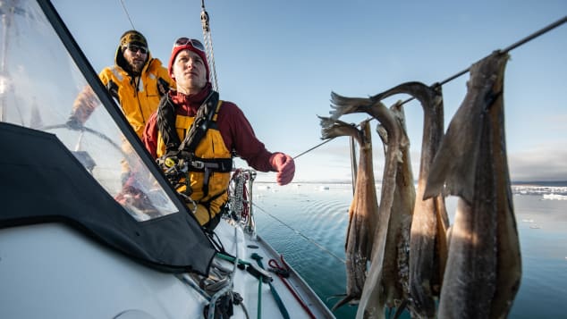
The sun never sets in the summer, so the crew had constant daylight for spotting ice.
@terragraphy/Daniel Hug

Dodging icebergs in the darkness, at least, wasn't something we had to worry about -- sailing in the Arctic during the summer means round-the-clock daylight.
And between all the excitement, nauseating swells and the fact that it never got dark, sleep was hard to come by.

Once we left the comfort of the last ports in Svalbard -- Longyearbyen followed by Ny-Ã…lesund, a research town where we partied like rock stars with scientists on a Finnish yacht, glacier ice cubes floating in our whiskey -- we were truly on our own, the boat our floating support system.
For 40 days, there was no internet, not to mention anywhere to provision for food and fuel (we had jerry cans of diesel strapped to the deck and refilled our water tanks with melt water from icebergs).
I had the boat's larder stocked with dried beans, potatoes, cabbage and other foods in it for the long haul, and once we ran out of fresh produce and meat, we kept happy with Arctic char we fished from the streams.
With no internet access to distract us, we'd long debate topics you could usually solve with a simple Google search.
Early on, we wondered if polar bears could climb aboard Barba from the water ("do polar bears board boats?" would have provided some quick answers).
But without instant Google satisfaction, we discussed for an hour how our first polar bear encounter might go.
The guys dubbed a jam-packed, below-deck storage locker accessed via a tiny door on the boat's stern the "bear bunker." They teased me (after all, I was the only crew member who'd never shot a gun) that I could sequester myself there if one ever clambered aboard.
Related contentIn Norway, kids are still making good money cutting cod tongues

Losing track of time under the midnight sun

When our first up-close bear encounter came, however, Google was far from our minds.
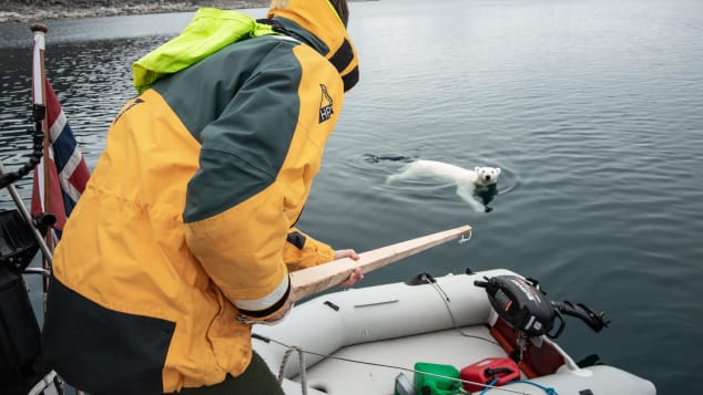
Early one morning on the island of Nordaustlandet on the west coast of Svalbard, with most of the crew still sleeping below deck, Heide sounded the alarm.

"Polar bear! Swimming toward the boat!," he shouted.
What I thought was a joke meant to send me scurrying for the bear bunker turned out to be the real deal.
We popped up on deck to see a polar bear paddling toward Barba, just a few yards off stern.

We had our flare guns and rifles ready, as one must with animals known to actively stalk humans But in the end, a wooden pole we used for pushing ice out of the way while motoring sufficed for keeping the bear at bay while we watched in awe.
A persistent juvenile -- and most likely hungry as there was no sea ice in the area for hunting seals (the captain had been diving in the same water the day before) -- the animal made several attempts to board us before giving up.
We had a theory that the cod drying on Barba's rails attracted the bear, but had it surprised us onboard, we would have easily found ourselves on the menu.

A wooden pole used to shove away ice came in handy during the crew's first up-close polar bear encounter.
@terragraphy/Daniel Hug

During the weeks that followed, as we circled the entire archipelago, we had six other polar bear encounters.
One lumbered across the beach like a brontosaurus, surprising me out the galley window while I was prepping tuna sandwiches for lunch.

Another kept two of the crew hostage inside a hunter's cabin on the beach, where they'd been trying to heat up a sauna so we could wash up.
The bear paced back and forth outside while those of us on the boat kept in VHF contact with the crew to let them know when it finally moseyed on.

Along with sea birds everywhere (feisty Arctic terns defending their nests, and huge glaucous gulls that made the Florida variety look like finches), there were Arctic foxes, curious reindeer and, once, an elusive pod of belugas that moved too quickly for us to snorkel alongside (yes, we tried).

As we made our way around the archipelago those weeks, we lost all track of time under the midnight sun that bobbed drunkenly above but never dipped close to the horizon.

Related contentA private island off the coast of Ireland just sold for $6 million.
The buyer only saw it in a video tour

It was exhilarating and exhausting.
We'd wake at noon, eat breakfast at 3 p.m., and finally nod off to sleep 12 hours later.
If we bothered to look at the clock, that is.

Time has no significance with the combination of no darkness, no stores or restaurants, no internet to distract you, no busy work to busy you -- and nobody else around for hundreds of miles.
Our only job was staying alive and enjoying all that wilderness.
When we finally made it as far as the ice would let us go, to 81 degrees north in the start of the dense pack ice surrounding the North Pole, Heide and I strapped on our scuba tanks and dived beneath a small berg, trusting our crew with their rifles ready above water to throw a flare and alert us if a bear approached.

Afterward, we all toasted our big adventure atop the same iceberg with a bottle of Schnapps -- then we jumped back onboard in a hurry, as the pack ice was closing in around us.
A harrowing hour followed as we made our way south, back toward the open water, as the ice and the changing wind direction threatened to squeeze us in.

We used wooden poles to push it away until we were finally out, every crunch and creak on the hull a reminder of our fragile home.

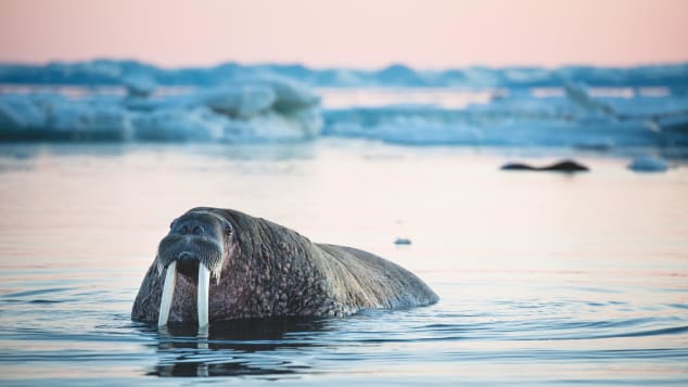
Nearly hunted to extinction in Svalbard over the course of centuries, walruses are making a comeback
@terragraphy/Daniel Hug

Walruses on the rise 

One of our last stops in Svalbard was Kapp Lee in the east, where hundreds of walruses hunt for shellfish (their mouths a powerful vacuum that sucks clams from the ocean floor) and haul themselves onto the dark sandy beach to socialize and sleep.
Nearly hunted to extinction in Svalbard over the course of centuries, the animals are making a comeback.
And it was a privilege to find ourselves and our tiny boat among them and the ice hugging the shore.

There, Grantangen, who always helped me with the laundry and talked books with me, too, taught me some military skills as we army crawled on the sand, silent as church mice, shimmying quietly on our bellies to within inches of one snoring walrus.

The animals are as agile as ballerinas in the water, but more awkward on land, where their eyesight is poorer, too.
The sleeping walrus was one in a herd of hundreds of juvenile and sub-dominant males (called a bachelor group), but we reckoned we could outrun the animals on land, even if they'd surely maul us in the water.
Still, my heart thudded in the sand as I watched drops of slobber glisten on its ivory tusks.

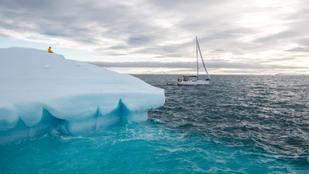
Ivan Kutasov sits atop an iceberg floating off Nordaustlandet, Svalbard's second-largest island.
@terragraphy/Daniel Hug

Home is where the anchor drop

It was late August.
And this far north, autumn roars in like a lion.
It was time to sail south to the home port -- back to the comforts of mainland Norway, back to our lives.

I turned 40 the day before I stepped off Barba for good.
My French boyfriend dressed like a captain to greet me in a chivalrous gesture I won't forget, there to accompany me home to the south of France.
But I was changed.

I soon realized we were trying to make something happen that wasn't in the cards from the beginning.

Those months in the Arctic taught me more than I knew about risk-taking and survival -- how to read the signs better in everyday life and go with your gut.

In a belated celebration of our 40th birthdays with my best friends in Jamaica later that year, I met a bachelor Cuban on a beach with no walrus in sight.
It was like hitting a speed bump -- or perhaps more like throwing out a drag anchor from a sailboat to stop you from barreling along in high winds in the wrong direction.
In a hurry, the Frenchman and I split.

Now, when the days blend into each other on land -- and with two half-Cuban toddlers underfoot, with no far-flung travels on the horizon for the foreseeable future -- I journey back in my mind to the place where I dived under an iceberg at 81 degrees north and snorkeled under a bird cliff prowled by polar bears.
To where I once crawled close enough to a walrus to watch its whiskers twitch.
Crew is currently being sought for Barba's 2021 expedition to Svalbard.


Tuesday, July 21, 2020

Sea turtles' impressive navigation feats rely on surprisingly crude 'map'

The animated travel tracks of 35 green turtle migrations tracked from nesting beaches in the Chagos Archipelago (Indian Ocean), highlighting the often circuitous routes of individual turtles.
Credit: Hays et al./Current Biology

From Phys

Since the time of Charles Darwin, scientists have marveled at sea turtles' impressive ability to make their way—often over thousands of kilometers—through the open ocean and back to the very places where they themselves hatched years before.
Now, researchers reporting in the journal Current Biology on July 16 have evidence that the turtles pull off these impressive feats of navigation with only a crude map to guide them on their way, sometimes going far off course before correcting their direction.

"By satellite tracking turtles travelling to small, isolated oceanic islands, we show that turtles do not arrive at their targets with pinpoint accuracy," says Graeme Hays of Australia's Deakin University. "While their navigation is not perfect, we showed that turtles can make course corrections in the open ocean when they are heading off-route. These findings support the suggestion, from previous laboratory work, that turtles use a crude true navigation system in the open ocean, possibly using the earth's geomagnetic field."

Despite much study of sea turtle navigation, many details were lacking.
Hays' team realized that was in part because most sea turtles return to spots along the mainland coast, which are also the easiest places to find.

For the new study, his team had attached satellite tags to nesting green turtles (Chelonia mydas) out of an interest in learning about the extent of the turtles' movements and to identify key areas for conservation.
In the process, they realized that, by serendipity, many of the tracked turtles travelled to foraging sites on isolated islands or submerged banks.
It allowed them to explore in more detail how turtles make their way to such small and harder-to-find islands.


The routes of 35 adult female green turtles travelling to their foraging grounds in the Western Indian Ocean after the end of the nesting season on Diego Garcia, Chagos Archipelago.
Credit: Hays et al./Current Biology

In total, the researchers recorded the tracks of 33 green sea turtles migrating across the open ocean from their nesting beaches on the island of Diego Garcia (Indian Ocean) to their foraging grounds across the western Indian Ocean, many of which were isolated island targets.
Using individual-based models that incorporated ocean currents, they then compared actual migration tracks against candidate navigational models to show that 28 of the 33 turtles didn't re-orient themselves daily or at fine-scales.

As a result, the turtles sometimes travelled well out of their way—several hundred kilometers off the direct routes to their goal—before correcting their direction, often in the open ocean.
Frequently, they report, turtles did not reach their small island destinations with pinpoint accuracy. Instead, they often overshot and or spent time searching for the target in the final stages of migration.

"We were surprised that turtles had such difficulties in finding their way to small targets," Hays says. "Often they swam well off course and sometimes they spent many weeks searching for isolated islands.
"We were also surprised at the distance that some turtles migrated.
Six tracked turtles travelled more than 4,000 kilometers to the east African coast, from Mozambique in the south, to as far north as Somalia.
So, these turtles complete round-trip migrations of more than 8,000 kilometers to and from their nesting beaches in the Chagos Archipelago."

The findings lend support to the notion that migrating sea turtles use a true navigation system in the open ocean.
They also provide some of the best evidence to date that migrating sea turtles have an ability to re-orient themselves in deep waters in the open ocean, the researchers say.
This implies that they have and rely on a map sense.
But the results also show that their map lacks fine details, allowing them to operate only at a crude level.

As a result of this imperfect navigation system, the turtles reach their destination only imperfectly.
In the process, the turtles spend extra energy and time searching for small islands.

The findings also have implications for the turtles' conservation, Hays says.
Turtles travel broadly across the open ocean once nesting season has finished.
As a result, he says, "conservation measures need to apply across these spatial scales and across many countries."

The researchers say that they hope the next generation of tag technology will allow them to directly measure the compass heading of migrating turtles as well as their location.
"Then we can directly assess how ocean currents carry turtles off-course and gain further insight into the mechanisms that allow turtles to complete such prodigious feats of navigation," Hays says.

Links :

Sunday, July 19, 2020

Canada (CHS) layer update in the GeoGarage platform

38 nautical raster charts & 2 new charts added

To the surface


“This whole crisis shows that we need to feed ourselves as close to home as we can.”
Jason Jarvis, local RI fisherman
Like most things, Covid-19 wreaked havoc on the RI seafood industry.
We wanted to explore this topic to raise awareness to the struggles and try to find some common sense solutions to the challenges (while being mindful of safety and social distancing).
Our DP Tyler Murgo grew up seeing his family harvest seafood from wild places.
As everything falls apart, it feels urgent to capture the wisdom and perspectives of local fishermen during this historical moment.
Some close to home, with Tyler’s brother Kenny Murgo, and others who have been fighting for change in RI for years like Jason Jarvis.
Huge thanks to them for trusting us to tell their story.
During production, on May 1st 2020, an emergency action passed, temporarily allowing fishermen in Rhode Island to sell finned fish directly off the boat to consumers.
The hope is to make this emergency regulation permanent.
Here are few steps to move further towards developing a local market for the wild food that lives in our backyards.
1. Go to your local port and try new fish you haven’t tried before.
2. Support small local fish markets that buy from local fishermen.
3. Demand local seafood from the restaurants and markets you go to.