
Original 1947 11-dashed lines map of China
entitled "Location Map of the South Sea Islands"
Five-part series summarizing and commenting the 5 December 2014 US Department of State “Limits in the Seas” issue explaining the different ways in which one may interpret Chinese maritime claims in the South China Sea.
It is a long-standing US policy to try to get China to frame her maritime claims in terms of UNCLOS.
Despite repeatedly stating that it will not take sides in territorial disputes in East Asia, Washington remains keenly interested in the ultimate fate of the South China Sea.
In addition to perennial calls to settle disputes peacefully, regular reminders of the importance of freedom of navigation, military aid to regional actors like the Philippines, and support for a more active policy by non-littoral maritime democracies like India and Japan, the US Department of State (DOS) took a further step late last year by issuing a document, part of its “Limits in the Seas” series. The text seeks to explain the different ways in which one may interpret Chinese maritime claims in the South China Sea (“that the dashes are (1) lines within which China claims sovereignty over the islands, along with the maritime zones those islands would generate under the LOS Convention; (2) national boundary lines; or (3) the limits of so-called historic maritime claims of varying types”).
It concludes that the “dashed-line claim does not accord with the international law of the sea” unless “China clarifies that” it “reflects only a claim to islands within that line and any maritime zones.”
The text includes supporting Chinese official views, without attributing “to China the views of analysis of non-government sources, such as legal or other Chinese academics.”
Concerning this latter restriction, although it is of course official sources which may be considered to be most authoritative when it comes to interpreting a government’s position, we should not forget that administrations in different countries will often resort to “two-track diplomacy” or employ semi or non-official back channels to test the waters and lay the groundwork for future formal negotiations.
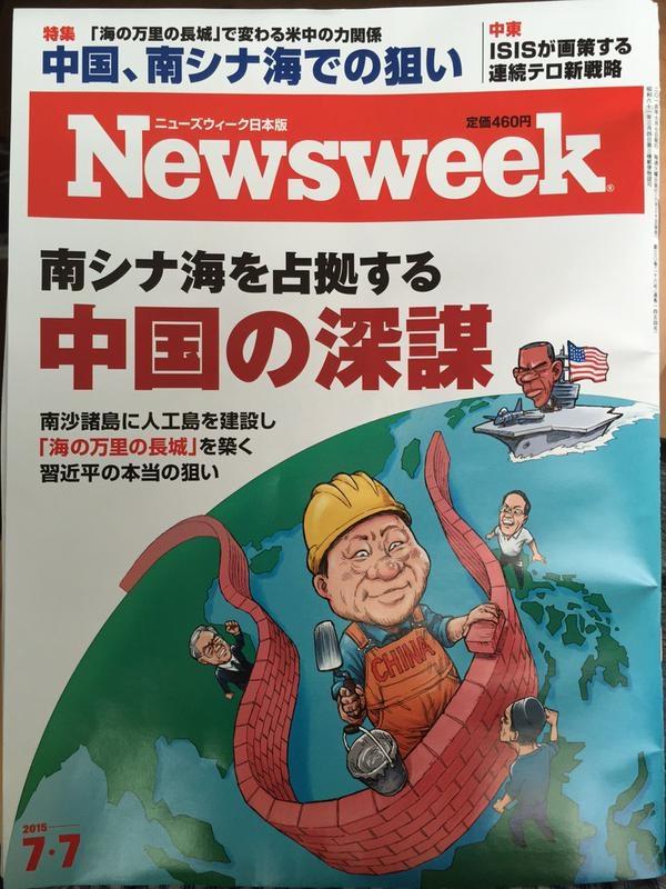
Newsweek Japan
The object of this five-part series is to summarize the DOS document, while commenting on some of its most relevant features, and where appropriate going beyond the text and examining related aspects of the South China Sea conflict.
Tyranny of History: Can Washington claim not to take sides on Filipino territorial claims?
Before summarizing the “Limits in the Seas” document, we should note that the American policy of not taking sides concerning the ultimate issue of sovereignty could be challenged given Washington’s past sovereignty over the Philippine Archipelago.
While this has not been publicly stressed by Manila to date, it could enter the debate as a means of putting more pressure on Washington to adopt a more robust posture.
Chinese Claims and Possible Interpretations According to International Law
In line with long-standing US demands that Beijing clarify the ultimate nature of her South China Sea claims, the DOS document analyzes those figures within UNCLOS and customary international law which may provide cover to Beijing’s claims.
Issued on 5 December 2014, the Department of State paper begins by stressing that “China has not clarified through legislation, proclamation, or other official statements the legal basis or nature of its claim associated with the dashed-line map”, explains the “origins and evolution” of the dashed-line maps, provides a summary of the different maritime zones recognized and regulated by UNCLOS, and then proceeds to explain and discuss three possible interpretations of that claim “and the extent to which those interpretations are consistent with the international law of the sea.”
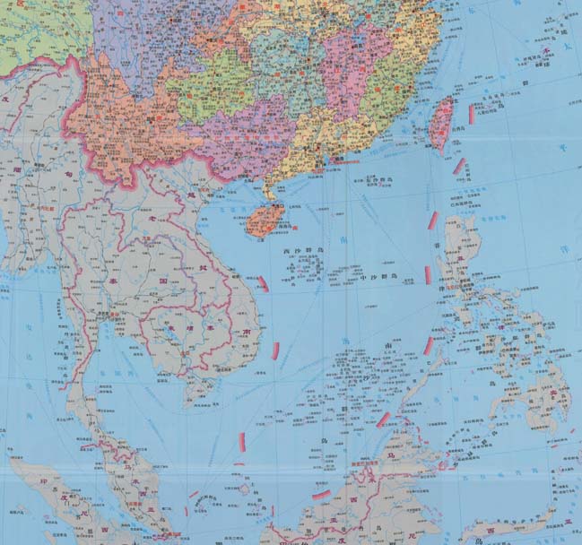
The document contains a number of maps, including (Map 1) that referred to in China’s two May 2009 notes verbales to the UN Secretary General, which stated that “China has indisputable sovereignty over the islands in the South China Sea and the adjacent waters, and enjoys sovereign rights and jurisdiction over the relevant waters as well as the seabed and subsoil thereof.
The above position is consistently held by the Chinese government, and is widely known by the international community.”

Nine-dash map attached to China’s two 2009 Notes Verbales
A Look at Chinese Map Quality and Accuracy
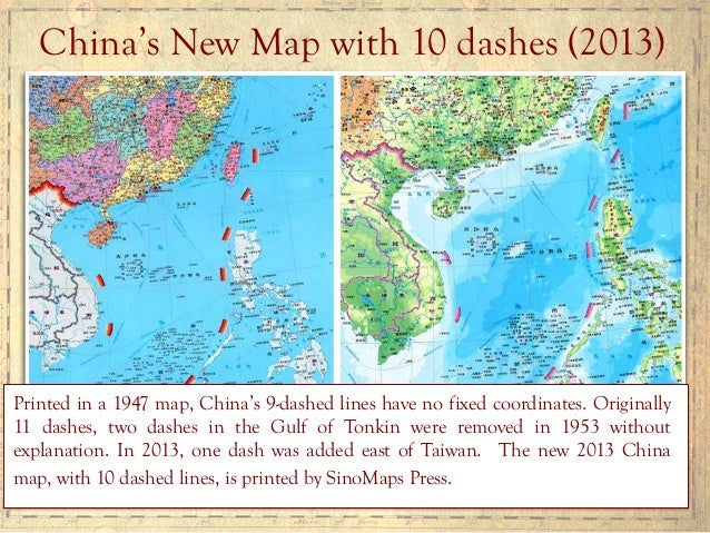
The text first outlines the history of China’s maps of the South China Sea containing dashed lines, starting with a 1947 map published by the Nationalist government, noting that later PRC maps “appear to follow the old maps” (see L. Jinming and L. Dexia, “The Dotted Line on the Chinese Map of the South China Sea: A Note”, Ocean Dev’t & Int’l L., Volume 34, 2003, pp. 287-95, p. 289-290) with two significant changes: the removal of two dashes inside the Gulf of Tonkin (in an area partly delimited by Vietnam and the PRC in 2000) and the addition of a tenth dash to the East of Taiwan.
These two changes can be interpreted in different ways, to some degree contradictory.
On the one hand, the partial delimitation agreement with Vietnam could be seen as evidence of Chinese pragmatism and flexibility, and proof that it is possible for countries in the region to at least partly settle their disputes by diplomacy.
On the other, explicitly encompassing Taiwan with an extra dash may be seen as a reinforcement of Chinese claims on the island not necessarily based on the will of her population.
Alternatively, it could simply be a way to more comprehensively encompass the waters and features that Beijing (either directly or via Taipei) wishes to master.
The paper then examines successive Chinese maps from a cartographic perspective, stressing that “China has not published geographic coordinates specifying the location of the dashes.
Therefore, all calculations in this study relating to the dashed line are approximate.”
A similar criticism has sometimes been made of the San Francisco Treaty.
The text also notes that “China does not assign numbers to the dashes,” and therefore those in the study are for “descriptive purposes only.”
They “are not uniformly distributed,” being “separated from one another by between 106 (dashes 7 and 8) and 274 (dashes 3 and 4) nautical miles (nm).”
This section of the paper stresses that “Nothing in this study is intended to take a definitive position regarding which features in the South China Sea are ‘islands’ under Article 121 of the LOS Convention or whether any such islands are ‘rocks’ under Article 121(3).”
This is in line with Washington’s refusal to take sides concerning the ultimate sovereignty disputes in the region.
The text notes that the “dashes are located in relatively close proximity to the mainland coasts and coastal islands of the littoral States surrounding the South China Sea,” and explains that, for example, Dash 4 is 24 nm from Borneo’s coast, part of Malaysia.
Generally speaking, “the dashes are generally closer to the surrounding coasts of neighboring States than they are to the closest islands within the South China Sea,” and as explained later this is significant when it comes to interpreting the possible meaning of China’s dashed line, since one of the principles of the Law of the Sea is that land dominates the sea, and thus maritime boundaries tend as a general rule to be equidistant.
That is, maritime boundaries tend to be roughly half way between two shores belonging to different states.
To hammer home this point, the study includes a set of six maps illustrating this.
The report criticizes the technical quality of the PRC maps, saying that they are inconsistent, thus making it “complicated” to describe the dashed line, whose dashes are depicted in different maps “in varying sizes and locations.”
Again, this is important in light of possible interpretations of Chinese claims, since this lack of consistency and quality not only obfuscates Chinese claims, introducing an additional measure of ambiguity, but also makes it more difficult to ascertain whether historical claims are being made and whether they are acceptable in light of international law.
The dashes change from map to map, with those “from the 2009 map” being “generally shorter and closer to the coasts of neighboring States” than those in the 1947 map.
The dashed lines in these two maps are illustrated and compared in Map 5 of the document.
The section concludes noting that the 2009 map, which Beijing distributed to the international community “is also cartographically inconsistent with other published Chinese maps.”
Reviewing maritime zones and historic claims
The paper’s second section basically consists of a summary explanation of “Maritime Zones,” “Maritime Boundaries,” and “’Historic’ Bays and Title” according to UNCLOS. Three aspects are of particular significance.
First of all, that the interpretation provided is not necessarily that considered correct by China. Although this is not always squarely addressed, when discussing whether Chinese claims in the South China Sea are or are not in accordance with international law we should first define international law, and there is the possibility that as China returns to a position of preeminence she may interpret some of its key provisions in a different way.
Second, as the paper itself notes, while China ratified UNCLOS in 1996, the United States has not, although she “considers the substantive provisions of the LOS Convention cited in this study to reflect customary international law, as do international courts and tribunals.”
Not all voices take such a straightforward view of Washington’s failure to ratify the convention while claiming that it is mostly a restatement of customary law and therefore applicable anyway.
The DOS paper includes a page devoted to “’Historic’ Bays and Title,” which text stresses that “The burden of establishing the existence of a historic bay or historic title is on the claimant,” adding that the US position is that in order to do this the country in question must “demonstrate (1) open, notorious, and effective exercise of authority over the body of water in question; (2) continuous exercise of that authority; and (3) acquiescence by foreign States in the exercise of that authority.”
This passage reflects the US traditional position, as noted by J. Ashley Roach and Robert W. Smith (Editors) “In December 1986, the U.S. Department of State, Bureau of Public Affairs, published ‘Navigation Rights and the Gulf of Sidra,’ in GIST, a reference aid on U.S. foreign relations.
The study discussed the history of U.S. responses, dating to the 18th century, to attempts by North African States to restrict navigation in these waters.
The GIST stated, in part, that: Current law and customs: By custom, nations may lay historic claim to those bays and gulfs over which they have exhibited such a degree of open, notorious, continuous, and unchallenged control for an extended period of time as to preclude traditional high seas freedoms within such waters.
Those waters (closed off by straight baselines) are treated as if they were part of the nation’s land mass, and the navigation of foreign vessels is generally subject to complete control by the nation.”
The text explains that this traditional American perspective is in line with the International Court of Justice and “the 1962 study on the ‘Juridical Regime of Historic Waters, Including Historic Bays,’ commissioned by the Conference that adopted the 1958 Geneva Conventions on the law of the sea.”
It cites a number of cases, among them the 1951 Fisheries Case (U.K. v. Norway).
It then turns its attention to the regulation of historic claims in Articles 10 and 15 of UNCLOS, saying that they are “strictly limited geographically and substantively” and apply “only with respect to bays and similar near-shore coastal configurations, not in areas of EEZ, continental shelf, or high seas.”
Just like, when examining China’s posture we must take into account, as discussed later, the country’s history, and in particular the Opium Wars and their aftermath, American history has also shaped Washington’s perceptions and principles.
The Barbary Wars were widely seen as laying down fundamental principles of national policy such as rejection of blackmail, freedom of navigation, and the right and duty to intervene far from American shores whenever the country’s interests, principles, and prestige were at stake.
In the words of Jason Zeledon “The United States’s conflicts with the Barbary States (Algiers, Morocco, Tripoli, and Tunis) from 1784-1815 gripped the young nation, featured bold attempts by American policymakers to defend U.S. trade in the Mediterranean region and assert leadership in international affairs, set important precedents in American foreign relations (including the first U.S.-supported coup attempt that generated the line ‘to the shores of Tripoli’ in the Marine Corps Hymn), provided vital naval training for the War of 1812, and helped create an early sense of American exceptionalism.”
South China Sea map first published in January 2013 by China’s state
mapping authority Sinomap Press, featureing 10 dashes instead of the
previous nine.
Thus, while China’s position concerning the South China Sea may end up resting at least in part, on the concept of historic waters, even if this is not the case history and perceptions of history will surely still play an important role in determining Beijing’s policy.
This, however, is not something only taking place within China, since no regional or extra-regional actor is immune to the phenomenon, adding to the already tense situation in South East Asia.
In particular, a couple of centuries later, both the Barbary Wars and the Opium Wars remain powerful factors projecting their shadow on American and Chinese foreign and defense policy.
Trying to make Chinese claims fit with UNCLOS: three possible interpretations.
The Department of State report then turns its attention to what constitutes the core of the paper, that is three possible interpretations of Chinese claims in the South China Sea and their compatibility or otherwise with International Law.
Even without the need to fully agree with the paper’s views, it responds to a widely heard demand for clarification of China’s posture.
In this regard, before we sum up the three perspectives, we should remember that while it is an interesting and useful exercise to try to fit Beijing’s (not always consistent) claims within the framework of UNCLOS and customary international law, China may have its own interpretations of the law, or seek to promote a different one.
Since international law to a great extent reflects power realities on the ground, this should not come as a surprise, in particular given that in the view of China’s leaders many aspects of international law, and in particular the law of the sea, result from the same power dynamics that led to the country’s fragmentation and subservience from the mid XIX Century.
The paper also stresses that it is only in “maritime claims” (emphasis in the original) where “China’s position is unclear.”
On the other hand, while some other countries do not accept them, Chinese claims on land are unequivocal, Beijing claiming “sovereignty over the islands within the dashed line”.
The assertion in China’s 2009 Notes Verbales that “China has indisputable sovereignty over the islands in the South China Sea” is consistent with previous statements, and means that there is no doubt that Beijing considers all such islands to be national territory of the PRC.
_-_Geographicus_-_EastIndies-cary-1801.jpg)
An 1801 map of the East Indies Isles.
Most of the names have changed since then.
“Dashed Line as a Historic Claim”
The third way to see the dashed-line, according to the Limits in the Seas series paper, would be as a historic claim.
Under UNCLOS this can take two forms, “one of sovereignty over the maritime space (‘historic waters’ or ‘historic title’)” or “some lesser set of rights (‘historic rights’) to the maritime space.”
The paper devotes much more room to discussing this possibility than to the two previous alternative interpretations.
It begins by pointing out that “some Chinese government statements and acts could be read to support a version of this historic claim interpretation”, and by noting that given that “the dashed-line maps pre-date the People’s Republic of China, the views of Taiwan are also of interest.”
Concerning the Island’s claims, the text underlines that while in 1993 its “Policy Guidelines for the South China Sea” said that the dashed lines enclosed a “’historic water limit’ within which Taiwan ‘possesses all rights and interests’” (see K-H. Wang, “The ROC’s Maritime Claims and Practices with Special Reference to the South China Sea,” Ocean Development and International Law, Volume 41, 2010, pp. 237-252), Taipei has not stuck to this view.
“Subsequent maritime legislation enacted by Taiwan and subsequent public statements, however, suggests that this view may no longer be officially held,” noted the State Department in another Limits on the Seas series issue, published in 2005, devoted to Taiwan.
While the text refers to this 2005 paper, the latter’s contents do not discuss in depth ROC claims on the South China Sea, as clear from the fact that the term “South China Sea” only appears three times, whereas “dash” is not to be found.
Thus, while the assertion that in studying PRC claims one should pay attention to ROC claims seems logical, this is not followed up, either in the 2005 Limits on the Issues paper devoted to Taiwan, or in the 2014 one dealing with China.
In other words, the Department of State does not follow its own advice.
How should we read this?
On the one hand, the preeminent use of “Taiwan” may seem to amount to a limited recognition of political realities on the ground, in opposition to Beijing’s views, further contradicted by the scant regard for ROC practice as opposed to the PRC’s emphasis on administrative and international legal continuity with the Nationalist regime.
An alternative, more Beijing-friendly, interpretation of the DOS approach may be that it is treating Taipei as the de facto authority on the Island, also for law of the sea purposes, while restricting its role in the South China Sea, where the PRC has consistently sought to exclude Taiwan from regional fora, in line with its traditional policy towards the Island.
More generally, this may reflect the complex and ambiguous status of Taiwan, with neither the Island itself nor countries like the United States completely sure what it is.
To add to the confusion concerning Taiwan in the DOS paper, it states on page 21 that “Many islands and other features in the South China Sea are occupied not just by China, but by … Taiwan,” yet again this is not followed by any detailed examination of Taipei’s claims.
Going back to evidence for the possible interpretation of Beijing’s claims as historic, the report cites as “most notable” China’s “1998 EEZ and continental shelf law, which states [in Article 14] without further elaboration that ‘[t]he provisions of this Act shall not affect the historical rights of the People’s Republic of China’” (emphasis added in the DOS report).
China’s 2011 Note Verbale says that Beijing’s claims are supported by “historical and legal evidence,” but while the DOS report adds emphasis to “historical”, one should be careful not to confuse a historical claim with a claim supported by history.
A country may put forward historical evidence in both negotiations and arbitration or adjudication in areas where UNCLOS refers to “equitable” solutions.
The text also notes how many “Chinese institutions and commentators have considered that the dashed-line maps depict China’s historic title or historic rights.”
The DOS reports explains that “some” Chinese Government actions and statements which are “inconsistent with” UNCLOS, while not amounting to “express assertions of a historic claim, they may indicate that China considers that it has an alternative basis – such as historic title or historic rights – for its maritime claims in the South China Sea,” and provides some examples, such as the assertion by Foreign Ministry Spokesperson Qin Gang on 10 March 2014 that the Second Thomas Shoal (Ren’ai Reef) was under Chinese “sovereignty.”
Qin Gang said “It is known to all that China has sovereignty over the Nansha Islands and their surrounding waters, including the Ren’ai Reef.”
This mantra about sovereignty, together with repeated appeals to history, could indeed be considered as evidence that what Beijing has in mind is a historic claim.
Furthermore, it may well be a claim going beyond the provisions for such term in UNCLOS. The report provides further evidence, beyond statements, to support the view that China may be making a historical claim.
First of all, the “periodic oath-taking ceremonies at James Shoal” by Chinese naval vessels “to affirm ‘sovereignty’ over this bank” and the 2012 introduction by the China National Offshore Oil Corporation (CNNOC) of lease blocks in front of Vietnam’s central coast, in “waters under jurisdiction of the People’s Republic of China” according to the company yet with “portions of two of these blocks (BS16, DW04)” extending “without explanation to waters that are beyond 200 nm from any Chinese-claimed island.”
The DOS report stresses that the resulting “assertion of maritime jurisdiction … exceeds what is provided for under” UNCLOS.
The idea that Chinese claims are “separate from, and additional to” UNCLOS is also suggested by domestic legislation, the DOS report notes.
As an example it cites China’s 1999 Law on Marine Environmental Protection, which describes its geographical scope as extending to the country’s “internal waters, territorial sea, contiguous zone, exclusive economic zone, continental shelf of the People’s Republic of China and other sea areas under the jurisdiction of the People’s Republic of China” (emphasis in the DOS report).
According to the text, UNCLOS is restricted to maritime zones mentioned in the law, and not to any “other sea areas under the jurisdiction” of the PRC, and “perhaps” this is a reference to “areas where China considers that it has historic claims.”
Again, we must remember that this could be understood in two different ways, either China making a claim based on historic facts (recognized to a limited degree by UNCLOS) or China laying down sovereignty over certain areas of the sea based on principles and rules outside UNCLOS, or outside the prevailing interpretation of UNCLOS.
Has China made a historic claim? Next the DOS report examines two issues: whether China has actually “Made a Historic Claim”, and whether it would “have Validity.”
Concerning the former, the text states that “China has not actually made a cognizable claim to either ‘historic waters’ or ‘historic rights,’” the reasons being a lack of “international notoriety” and the statement in her 1958 Territorial Sea Declaration that “high seas” separate the Chinese mainland and coastal islands from “all other islands belonging to China”.
The text admits that the expression “historic waters” appears in some Chinese legislation and statements, and actually cites some of them, but believes that this does not amount to “notoriety” to a degree sufficient to “at the very least” allow “other states” to “have the opportunity to deny any acquiescence with the claim by protest etc.” (Taken from C.R. Symmons, Historic Waters in the Law of the Sea: A Modern Re-Appraisal, (Leiden: Martinus Nijhoff Publishers, 2008), p. 145) since “no Chinese law, declaration, proclamation, or other official statement” exists “describing and putting the international community on notice of a historic claim.”
The text dismisses references to “historic rights” in the 1998 EEZ and continental shelf law as “a savings clause” and “not a statement of a claim itself.”
An additional reason put forward by the text is that these could be references to “China’s sovereignty claim to the islands, and not the waters.”
The 1947 map does not constitute either, according to the DOS report, a claim, and furthermore even if one had been made, the fact it was published domestically “in the Chinese language” would not amount to “an act of sufficient international notoriety to have properly alerted the international community.”
More generally, the text considers that no subsequent Chinese map can be treated as having made a claim either, since they all “lack the precision, clarity, and consistency that could convey the nature and scope of a maritime claim” and cites in support of this view the ICJ “statement of principle” in the Frontier Dispute case between Burkina Faso and Mali, which says that “Whether in frontier delimitations or international territorial conflicts, maps merely constitute information which varies in accuracy from case to case; of themselves, and by virtue solely of their existence, they cannot constitute a territorial title, that is, a document endowed by international law with intrinsic legal force for the purpose of establishing territorial rights.”
Whereas the assertion that China has not actually made a claim may not be shared by everybody, in particular given the language flowing from Beijing which the DOS report itself cites, the reference to the “high seas” between mainland China and some islands seems stronger proof that Beijing was not making a historic claim.
However, we must again stress that this would be the case if we followed the prevailing interpretation of the law of the sea, but there is no reason why China should adhere strictly to it, and even less that Beijing should not have changed her mind since 1958, when she had little more than a coastal navy and her economy was closed and in tatters.
It may be true, as the report notes, that the 1958 Declaration only made a historic claim to the Bohai (Pohai) gulf in northeastern China, but again this should perhaps be judged from a wider historical perspective.
After 1949 the PRC took a much more uncompromising stance concerning its North-East than its South-East (and wider maritime) borders.
With a pragmatic arrangement in place with the United Kingdom concerning Hong Kong, and a strong economic and political relation with the Soviet Union, it was at the other end of the country where, in 1950, Beijing (not without an intense internal debate given the state of the country), decided to resort to force to prevent the presence of hostile forces close to her border, intervening in the Korean War, pushing back the advancing Allied forces and reversing the impact of the Inchon landing, ultimately forcing a stalemate on the ground.
In 1958, just five years after the Korean armistice, nearby waters may have thus been much more present in Chinese leaders’ minds.
In addition, these were also the waters directly leading to Tianjin and Beijing, the venue for foreign interventions in both the Opium Wars and the Taiping Rebellion.
It would not be until the late 1970s that China’s South-Eastern flank would begin to receive more attention, in part thanks to the rapprochement with the United States and in particular once economic growth and the country’s move to become a net energy and commodity importer turned the waters of the South China Sea into a vital venue and potential choke point.
It is true that in December 1941 the loss of HMS Prince of Wales and HMS Repulse in the South China Sea had enabled the Japanese to land in Malaya and ultimately conquer Burma, closing the last land route to besieged Nationalist China, but this did not result in a comparable imprint on China’s historical consciousness, among other reasons because the episode did not involve Chinese naval forces and was subsumed into a much larger, dramatic, and quickly-developing picture.

Rejecting the validity of a possible historic claim by China.
Concerning whether, if China “Made a Historic Claim”, it would “have Validity”, the DOS paper insists that “such a claim would be contrary to international law”, stressing the limited degree to which UNCLOS recognizes this category of claims, as evidenced by its “text and drafting history”. The text argues that “apart from a narrow category of near-shore ‘historic’ bays” in Article 10, and “historic title” concerning “territorial sea boundary delimitation (Article 15)”, “modern international law of the sea does not recognize history as the basis for maritime jurisdiction”, citing the Gulf of Maine ICJ case.
It also underlines the fact that UNCLOS provisions concerning the EEZ, continental shelf, and the high seas “do not contain any exceptions for historic claims” to the detriment of coastal states and all estates enjoying certain freedoms.
Concerning fisheries, the report acknowledges that UNCLOS refers to “the need to minimize economic dislocation in States whose nationals have habitually fished” in the EEZ (Article 62(3)) and to “traditional fishing rights and other legitimate activities” (Article 51), but restricts the impact to the possible granting by one state to another of fisheries resources “based on prior usage”.
The text stresses that no such traditional fishing practices can “provide a basis for sovereignty, sovereignty rights, or jurisdiction,” adding that UNCLOS rules on oil and gas development contain no “exception for historic rights in any context.”
Again we note how a purely legal report like this may be missing part of the picture, given the great importance that fishing vessels have in the ongoing conflict over the South China Sea, where they are one of the pillars of asymmetric naval warfare.
Chinese scholars Gao and Jia have argued that UNCLOS does not regulate “historic title” and “historic rights,” which fall instead under the purview of general international law.
In their view, UNCLOS “was never intended, even at the time of its adoption, to exhaust international law.
On the contrary, it has provided ample room for customary law to develop and to fill in the gaps that the Convention itself was unable to fill in 1982” as clear from its preamble, which reads “matters not regulated by this Convention continue to be governed by the rules and principles of general international law.”
The DOS report explicitly rejects this position, saying that “it is not supported by international law” and goes against the “comprehensive scope of the LOS Convention.”
Experts like Mark Valencia, on the other hand, hold that China’s posture may be compatible with the international law of the sea.
The text does not stop at arguing that it is not open to a state to make historic claims based not on UNCLOS but on general international law, laying down a second line of defense.
It explains that, “even assuming that a Chinese historic claim in the South China Sea were governed by ‘general international law’ rather than the Convention,” it would still be invalid since it would not meet the necessary requirements under general international law, namely “open, notorious, and effective exercise of authority over the South China Sea,” plus “continuous exercise of authority” in those waters and “acquiescence by foreign States” in such exercise of authority.
Furthermore, it explains that the United States, which “is active in protesting historic claims around the world that it deems excessive,” has not protested “the dashed line on these grounds, because it does not believe that such a claim has been made by China,” with Washington choosing instead to request a clarification of the claim.
Whether this view is also meant to avoid a frontal clash with Beijing, in line with the often state policy goal of “managing” rather than “containing” China’s rise, is something not discussed in the text.
The report concludes by criticizing another view put forward by Gao and Jia, namely the relevance of claims made before the advent of UNCLOS.
While these two scholars argue that “In the case of the South China Sea as enclosed by the nine-dash line, China’s historic title and rights, which preceded the advent of UNCLOS by many years, have a continuing role to play,” the DOS paper says that “The fact that China’s claims predate the LOS Convention does not provide a basis under the Convention or international law for derogating from the LOS Convention,” adding that “permitting States to derogate from the provisions of the Convention because their claims pre-date its adoption is contrary to and would undermine” the convention’s “object and purpose” stated in its preamble to “settle … all issues relating to the law of the sea.”
Conclusions
Long-standing American policy towards China stresses the need to manage the latter’s rise, so that it does not threaten the post-Second World War system, based among others on freedom of navigation and a ban on territorial expansion as a legitimate causus belli.
As a result, Washington has often called on Beijing to clarify her claims on the South China Sea, in an attempt to constrain them while avoiding a frontal clash.
This position also seeks to reinforce the perception that the United States focuses on the rule of law at sea, rather than on supporting one claimant against the other over disputed waters.
The DOS document, in line with this approach, carefully dissects Chinese claims, analyzing whether they may be compatible with standard American interpretations of international Law of the Sea.
The conclusions are rather pessimistic, exposing how, despite having ratified UNCLOS, the Convention’s provisions are not seen in the same light by Beijing and Washington.
This should not surprise us, since international law seeks to constrain power but at the same time it is shaped by it, thus as countries rise they seek to play a greater role in the fate of rules and principles. In the case of China this is even clearer due to historical perceptions that it was to a large extent seaborne power which subjected the country to a semi-colonial status for a whole century.
If Beijing’s claims in the South Chinese Sea cannot be seen in the light of UNCLOS, the question arises what ultimate Chinese goals are.
Could this be the subject of a future paper by the Department of State?
Or does Washington prefer to wait until the international arbitration case launched by Manila concludes?
While the second option seems more likely, as time goes by the idea that China’s rise may be shaped, rather than constrained, increasingly seems less and less realistic.
However, if the time comes to draw a line in the sand, a whole of government effort will be needed, going beyond the naval circles that to date have been most vocal in articulating the need to resist Chinese expansion.
Links :
- USC Libraries : Asian ancient maps collection / Sea Korea ancient maps collection
- CIMSEC : South China Sea Arbitration : Beijing puts forward her own views (part I / II / III)
- Statfor : A Glimpse into China's military presence in the South China Sea
- Washington Post : Satellite images show China may be building powerful radar on disputed islands
No comments:
Post a Comment