Johan Potgieter has an EXTREMELY close encounter with a Great White Shark off the coast of South Africa.
Film teaser : 47 Metres Down review – shark-cage thriller sinks to the bottom
This film labours unpretentiously in the shadow of Spielberg’s Jaws, before it is almost harpooned by an outrageous final twist
A follow-up to the recent great white shark cage breach accident video showing the whole story in context. It includes the original cage breach footage and an analysis. Even though the shark gets into the cage, it's not a shark attack. In the moment this was a horrifying shark encounter but it ended good for both the shark cage diver and the great white shark!
A follow-up to the recent great white shark cage breach accident video showing the whole story in context. It includes the original cage breach footage and an analysis.
Even though the shark gets into the cage, it's not a shark attack.
In the moment this was a horrifying shark encounter but it ended good for both the shark cage diver and the great white shark!
From Europeana Labs by Annapaula Freire de Oliveira Get making with our favorite world maps
We can hardly imagine our daily lives without the precise location information we have at our fingertips – on the screens of our mobile phones or computers.
The last century is considered to be a golden age of map-making.
It has transformed our everyday lives and knowledge of the world, and the digital revolution continues!
However, before globetrotters could trust digital maps to guide them to faraway places, early explorers had to resort to much simpler representations of the world, often drawing the maps themselves throughout their travels.
If you’re fascinated by maps and their history, join us as we outline how early cartographers represented the world as they knew it.
Check out our selection of freely to reuse world maps below to see how cartographers found different ways to represent their understanding of our planet.
T-O maps
The T-O map represents the physical world as first described by the 7th-century scholar Isidore of Seville.
Below a detail of a 14th century 'T-O' map of the world, with Asia, Europe, and Africa marked.
A mappa mundi is a medieval European map of the world.
Take a look at a reproduction of one of the world's most famous maps, named after the Hereford Cathedral in England.
Typical of many medieval maps, the center of the world is presented as the holy city of Jerusalem.
Earth is depicted as a disk and as land surrounded by seas.
Based on the account of the traveler Niccolo da Conti to Asia, the Genoese map is a 1457 world map that possesses a Genoese flag in its upper northwest corner, along with the coat of arms of the Spinolas, a prominent Genoese mercantile family.
An atlas is a collection of maps.
Find below a 16th century map from the Water Atlas of the World representing the proverbial "four winds", one from each of the cardinal points - North, South, East, West.
Next, an atlas containing 32 maps from around the world.
It’s divided in two parts: the first identical to the 1650 edition, the second one is an atlas of the ancient world dedicated to Greece and nearby regions.
Biblioteca Virtual Del Patrimonio Bibliográfico. CC BY.
Finally, check out a 17th century map with two hemispheres, one showing North and South America, the other Europe, Asia and Australia.
At the top and bottom there are illustrations depicting the elements "air","fire", "earth", and "water".
ARGOS has always connected mobiles everywhere on the planet.
CLS, which has operated the ARGOS satellite system since its creation, thus has all the ARGOS For NEXT GENERATIONS knowledge, professional skills, infrastructures and networks needed to work on ARGOS for Next Generations.
CLS’s mission will be to offer a new system which will give connected objects an entirely new dimension.
A universal connection, which will make the IoT available all over the world. ARGOS will be radically changing its scale of operation!
The satellite-based Internet of things (IoT) will be accessible everywhere, for a sustainable planet.
From location and data collection through to processing, the new-generation ARGOS system will offer information that has been integrated especially for its users’ professions.
Ship-owners, biologists, scientists, environmental protection stakeholders and fishery administrators will all benefit from improvements that enhance their studies, performance and daily management.
To achieve this, DATA ANALYTICS, BIG DATA and DATA MAPPING will be the watchwords for this entirely new generation ARGOS system.
The future system will usher in a radical change of scale.
A revolution in scale will be undertaken while respecting the values of CNES, CLS and the ARGOS system, with a view to protecting our planet, sustainably managing its marine resources and thus protecting humanity.
The Paris-Air Show at Le Bourget was an opportunity for CLS to begin preparing the next step in ARGOS’s future, with our full support.
The ARGOS system was one of the first satellite location and data collection systems.
It contributes a great deal to our knowledge of the environment and its protection. In this context, borne by the worldwide enthusiasm during the COP21, CLS decided to name this key, future system for the environment : “ARGOS for next generations”.
While 2020 will mark the launching of the 5G offer, the current decade is that of very high speed networks, including:
A fixed, very high speed fibre optic network, supported and deployed in France by the “France Très Haut Débit” plan.
A very high speed mobile network based on 4G.
As Internet connectivity improves, its role in economic growth and human activity is becoming essential.
How then can we accept that a significant part of our own country, just like most of Africa, has no Internet access?
Likewise, how can we imagine ourselves, whether representing a company or as an individual, not being connected while sailing across the oceans or flying over the sea or over practically uninhabited territories?
Well that’s the case today!
In France, in spite of all the private and public initiatives, more than 1.2 million homes will still lack a very high speed connection in 2022.
In Africa, South America, Asia and even some European regions, it is not possible to deploy mobile networks without satellites that link the relay antennas to the rest of the network in zones where the ground infrastructures are inadequate.
As for sailing or flying over the seas or vast, practically uninhabited landmasses, satellites remain the only conceivable connectivity solution.
However, the space sector, with support from the public authorities, has been able to innovate in time and prepare these new types of satellite.
Designed especially for Internet, they will convey data at a sustainable cost for new applications.
They will be offering unprecedented throughput.
In 20 years the total capacity of communication satellites has already been increased a thousand times!
This more or less matches the doubling every two years, predicted by Moore’s law for transistors.
Clearly the space industry is a fundamental source of innovation behind the current technological and industrial revolution.
This French space team has developed new geostationary platforms, called NEO; furthermore it has generalized the use of high-powered electrical propulsion, has designed high-capacity Internet payloads and has been able to produce and deploy the corresponding ground segments.
One might add as well, the integration of advanced digital processes to enable very flexible payloads;
All these innovations are essential building blocks that have been developed by the French space team.
Of course, apart from these innovations, one should also mention Ariane 6, which will be used to launch these new-generation satellites.
So there are solutions and it is now up to be operators to grasp and deploy them.
In parallel with the development of these geostationary satellites, which have accounted for practically the whole commercial SATCOM market for more than 20 years, projects for Internet satellite constellations in low or medium Earth orbit have emerged, such as O3B, Oneweb, Leosat and others which are apparently now being developed.
The space offer has diversified and grown to rapidly meet the many new need.
For the general public, this IoT may for instance take the form of sensors worn by individuals to monitor their health.
The signals produced are transmitted by mobile telephones to servers which analyse them.
For the industrial world, the IoT is a key component of tomorrow’s factories.
For these applications, satellites are of course not the standard solution.
But the Internet of Things also includes monitoring of the environment, tracking of aircraft and ships and monitoring logistics and supply chains from Chengdu to Cedar Rapids or Bourges: for those applications, only satellites are able to provide the worldwide coverage needed, by efficiently compensating for the limits of ground- based networks.
Some first-generation space systems have already been deployed.
They partially meet the needs for satellite-based IoT.
Several initiatives are now emerging, particularly in North America but also in China and Australia.
The French space team is already active in this field and, as I have already said, has the know- how for offering the most competitive solutions.
It is necessary however to work together, if possible, to pool the know-how and resources to launch a major initiative in the field.
CNES is completely committed to this strategy.
The work done by CLS is the right framework for this cooperation, and ARGOS is clearly the best system around which to build a satellite-based IoT!
Satellite-based IoT... ARGOS has been doing this for more than 30 years, by collecting data for scientific and environmental purposes across the entire planet!
CLS will have the full support of CNES and its engineers.
The same engineers who invented ARGOS 30 years ago!
The same engineers who have developed it right up to its fourth generation.
And no player is more qualified than CLS, which has been operating and marketing the ARGOS system, to supervise the upgrading of the system for new applications and services.
This will be done by adding a complement to the “historical” ARGOS system, based on three polar orbits, and to which we are and will remain fully committed.
CLS will have the full support of CNES and its engineers.
These same engineers who invented ARGOS 30 years ago!
The same engineers who have developed it right up to its fourth generation.
Any industrial companies that could contribute their know-how for defining the system and the satellite constellation are thus invited to contact CLS.
Likewise, for all those with business projects in the IoT field who would like to share this system and invest in it.
The ARGOS Goniometer is a direct receiver used to collect your data and decode GPS positions in real-time. The CLS goniometer has been designed by CLS to specifically allow users to find active ARGOS platforms in the field.
Depending on the altitude and the reception conditions the goniometer can detect all transmitting platforms within a radius of 100 km or more.
CNES will be carefully monitoring the progress of the project over the next few months.
IoT, the Internet of Things, is now emerging in consumer markets.
With ARGOS for NEXT GENERATIONS, CNES and CLS intend to make the IoT available anywhere on Earth.
CNES, with its visionary innovation, created the ARGOS satellite-based location and data collection system in the 1980s and for the first time ever, collected data from animals, drifting buoys, hydrology stations, volcano-monitoring platforms and fishing vessels.
The future of our fisheries depends to a large extent on our ability to preserve stocks effectively. CLS has been certified by most of the leading seaboard nations around the world and is already operating on thousands of vessels worldwide.
The ARGOS location and data collection system has always been a precursor:
It was the first constellation dedicated to the environment in the 1980s,
It became an international constellation in the 1990s,
It offered two-way broadband capability from 2000 on,
It added miniaturization in 2010; the smallest ARGOS transmitter only weighs 2 grams.
One of the main advantages of the system is that it requires very little power, which means small, autonomous transmitters can be manufactured.
The history of animal migrations has also been rewritten, with more than 100,000 animals tracked thanks to ARGOS.
Oceanography has become operational and is now used for weather forecasting and climate studies
Fishery administration has undergone a major revolution and it is now possible to track industrial ships at sea anywhere in the world, with a fully secure communications system!
Coordinates determined with ARGOS by means of Doppler location cannot be tampered with and thus enable authorities to monitor fishing vessel activities in an entirely secure way.
CLS solutions include a wide range of services based on proven and innovative space technologies. As a result of 30 years of close collaboration with governments and agencies in charge of maritime surveillance, and maritime industry operators.
ARGOS has always connected mobiles everywhere the planet.
CLS, which has operated the ARGOS satellite system since its creation, thus has all the knowledge, professional skills, infrastructures and networks needed to work on ARGOS for Next Generations.
CLS’s mission will be to offer a new system which will give connected objects an entirely new dimension.
A universal connection, which will make the IoT available all over the world.
ARGOS will be radically changing its scale of operation!
From location and data collection through to processing, the new-generation ARGOS system will offer information that has been integrated especially for its users’ professions.
Ship-owners, biologists, scientists, environmental protection stakeholders and fishery administrators will all benefit from improvements that enhance their studies, performance and daily management.
To achieve this, DATA ANALYTICS, BIG DATA and DATA MAPPING will be the watchwords for this entirely new generation ARGOS system.
The future system will usher in a radical change of scale.
Data collectors will hence become information providers.
The new ARGOS system which professionals will be able to use directly, will help them make decisions on a daily, operational basis.
A revolution in scale will be undertaken while respecting the values of CNES, CLS and the ARGOS system, with a view to protecting our planet, sustainably managing its marine resources and thus protecting humanity.
The Yara Birkeland, slated for launch late in 2018, will make short trips delivering fertilizer
Two Norwegian companies are taking the lead in the race to build the world’s first crewless, autonomously operated ship, an advance that could mark a turning point in seaborne trade.
Dubbed by shipping executives the “Tesla of the Seas,” the Yara Birkeland now under development is scheduled in late 2018 to start sailing fertilizer 37 miles down a fiord from a production facility to the port of Larvik.
Using the Global Positioning System, radar, cameras and sensors, the electric ship is designed to navigate itself around other boat traffic and to dock on its own.
The first commercial autonomous vessel in the world, and also the first commercial zero ballast vessel.
A game changer for the environment and for the shipping industry.
The vessel will cost $25 million, about three times as much as a conventional container ship of its size, but its backers say without need for fuel or crew it promises to cut annual operating costs by up to 90%.
The 100-container ship is scheduled to be in the water toward the end of next year, though initially it will be tested with a human at the controls.
The Birkeland is being jointly developed by agriculture firm Yara International ASA and Kongsberg Gruppen AS A, which builds guidance systems for civilian and military uses.
Petter Ostbo, Yara’s head of production who leads the project, said the company would look to invest in bigger ships and use them for longer routes once international regulations are in place for crewless vessels.
“Maybe even move our fertilizer from Holland all the way to Brazil,” he said.
Companies and universities are working together to develop automated cargo ships.
The Wall Street Journal looks at Rolls-Royce’s concepts for the next revolution in maritime transport.
Photo: Rolls Royce.
The International Maritime Organization, which regulates maritime travel, doesn’t expect legislation governing crewless ships to be in place before 2020.
Shipping executives say autonomous vessels will be popular for short sea routes, but doubt they will replace oceangoing ships that move thousands of containers across continents with an average crew size of around 25.
“It’s not a matter of technology, which is already there, but a business case,” said Lars Jensen, chief executive of SeaIntelligence Consulting in Copenhagen.
“Autonomous ships are expensive to begin with, and have to be built very robust, because if they break down, the cost of getting a team to fix them it in the middle of the ocean will be very high.”
In addition to reducing fuel and labor costs, the Birkeland project is being pitched as a way to cut emissions.
The ship is expected to replace 40,000 truck drives a year through urban areas in southern Norway, the companies say.
Ship operators increasingly are being asked to introduce cleaner fuels when sailing close to populated coastal areas, especially in the U.S. and Europe.
“We want to go zero emission,” said Mr. Ostbo.
“Even if some say climate change is not reality, it’s a business reality because clean sources of energy are more affordable than fossil fuels.”
An entire Norwegian fjord now opens for testing autonomous ship
technology. Test-site Trondheimsfjorden is right on the doorstep of a
world class research community - eager to take autonomous technology to
the next level.
The Birkeland will become autonomous in stages.
At first, a single container will be used as a manned bridge on board.
Then the bridge will be moved to shore and become a remote-operation center.
The ship will eventually run fully on its own, under supervision from shore, in 2020.
“When the bridge goes on land, it will be something like flying a drone from a command center,” said Kongsberg’s chief executive, Geir Haoy.
“It will be GPS navigation and lots of high-tech cameras to see what’s going around the ship.”
The Norwegians aren’t alone in looking into autonomous shipping.
British manufacturer Rolls-Royce Holding PLC is investing in similar technology and plans to launch robotic ships by 2020.
The first vessels will likely be tugboats and ferries, with cargo ships that can sail through international waters to follow.
“Once the regulation is in place, I can see this spreading fast,” Mr. Haoy said.
“There is a lot of interest from operators of coastal tankers, fish-transport vessels and supply ships that are knocking on our door.”
In December 2013, I wrote stories about the “magenta line” on our
nautical charts depicting the Intracoastal Waterway, and now lawyers
want me to answer questions for a court case on the subject.
Here’s what
I wrote in one of the articles:
For
years experienced boaters have known that the magenta line should be
viewed with skepticism as an indicator of depth. But at the same time
they appreciated the fact that it provided an easy way to follow the
ICW’s route as it winds through the labyrinthine systems of creeks,
rivers, and canals that comprise the waterways of the coastal South.
The problem is that some novice boaters have no compunction about
speeding down that dotted line like it was the center lane of I-95, and,
as NOAA officials recently wrote in their request for comments on the
Federal Register, “Numerous examples can be found where the charted
Intracoastal Waterway Route (“magenta line”) passes on the wrong side of
aids to navigation; crosses shoals, obstructions, shoreline; and falls
outside of dredged channels, etc.” It’s a fact that anyone who
follows the magenta line closely enough and far enough will go aground,
as I recently demonstrated at a known trouble spot on the ICW at Crooked
River in Georgia. The fact that I intended to follow the line until I
touched bottom softened the blow, but some hard-charger would have
experienced the nautical equivalent of a car wreck.
The Feds removed much of the magenta line from government charts, citing
safety concerns, but the electronic cartography industry—Navionics,
C-Map and Garmin—did not follow suit.
Customers like the magenta line,
they say.
Red Marker 38 with magenta line on Navionics webmapping
Then came that “hard-charger” I was predicting. On Dec. 27, 2014, a
year after that article, Pedro Torres of Tampa was westbound on the St.
Lucie canal at 21 knots. Seaduction, his Wellcraft 36, was
equipped with a Garmin chartplotter, and Torres was riding the magenta
line as many of us do.
Unfortunately the line veered to the wrong side
of Red Marker 38, so instead of taking the mark properly to starboard,
Torres took it to port.
The boat exited the channel and slammed into a
shoal.
And the result was the equivalent of a car wreck
without the benefit of air bags.
Torres’ wife Christine was thrown below
on impact, suffering injuries to her spine, neck and skull, including a
badly bleeding head wound and broken bones.
She was airlifted to a
nearby hospital in critical condition.
Florida Fish & Wildlife
investigators concluded that Torres’ inexperience and inattentiveness
contributed to the accident but that he had broken no laws.
Last
year, Christine Torres filed suit against Garmin, alleging that the
company “knew that its decision to retain and display the magenta line
as the ‘recommended route’ without any ‘ground-truthing,’ changes,
corrections or warnings would place its users and their innocent
passengers in grave danger.”
Garmin fixed the error by moving the
magenta line to respect Red Marker 38, and prepared to defend itself in
court.
Pedro Torres, Garmin’s lawyers argue, had behaved like a
knucklehead when he mindlessly followed a colored line on his plotter.
They insisted that the court assign part, if not all the blame for his
wife’s injuries to him in its final decision.
Okay, many of us
waterway veterans are nodding our heads in agreement right now, aren’t
we?
But let’s look at it through the eyes of a South Florida jury,
particularly after it’s heard from some of the experts rounded up by
Torres attorney Michael Eriksen.
One is Anthony Andre, a Ph.D who
researches human factors, ergonomics and usability in product design.
His expertise includes the concept of “automation trust.”
From a court
document:
Dr.
Andre is expected to testify that (1) Garmin’s public relations and
marketing information invites trust in Garmin and its products; (2) It
was feasible for Garmin to perform a human factors evaluation of the
subject interface, taking into account the principle of automation
trust; (3) Garmin’s failure to employ human factors specialists to do so
did not comply with generally accepted principles and guidelines
applicable to interface design; (4) Garmin’s continuing use and display
of known chart “errors and defects,” such as a “recommended route” drawn
on the incorrect side of channel markers, was similarly contrary to the
referenced human factors principles…
Andre’s attack goes on and on.
Lee
Alexander is another witness with a Ph.D and a heavy hitter in
electronic charting, theory and practice.
His testimony would center on
“ground truthing” and the fact that Garmin had the means to determine
the accuracy of the magenta line but failed to do so.
So what does
a jury—perhaps lacking in judgmental old salts—make of all this? Garmin
could well have a problem.
The government got rid of the magenta line
because it was dangerous.
Garmin did not.
Pedro Torres spent, say,
$20,000 on a Garmin electronics suite.
Why would he not trust his marine
chartplotter the way the jurors hearing his case trust the GPS in their
cars?
After all. if you hover the Garmin plotter’s cursor over the
magenta line, the words that pop up on the screen are: “Recommended
Route.”
By the way, C-Map has a correct line at Marker 38, while Navionics
appears to have three to choose from, one of which cuts the mark.
I have
brought this to Navionics’ attention so it can be fixed.
This is the magenta line at the accident scene prior to NOAA's decision to remove the line.
Note that the scale of the chart is such that there's no way to conclude that the line might pass to the wrong side of Red Marker 38.
Zoom in on an electronic chart, however, and there is literally room for error.
View in the GeoGarage platform (NOAA RNC 11428) today View in the GeoGarage platform (NOAA ENC) today
So what’s my
role in the Torres case?
Back in 2013 I made a query to Garmin about
the magenta line, which sparked an internal debate. The resulting chain
of emails has become evidence in the case.
The lawyer for Christine
Torres says he wants to question me about the articles I wrote at the
time and my Garmin query in a deposition.
Here’s what I asked a Garmin spokesman back in 2013:
Wes, The
federal government is eliminating its “magenta line” from East Coast
ICW charts. NOAA says this “best route” indicator is no longer valid, so
it is eliminating the line while it considers what to do next. The
question for Garmin is this: There are three choices Garmin has.
It can eliminate the magenta line from its cartography; it maintain the
line as it is now, even though the government no longer stands behind,
or it can develop a third option. What is Garmin going to do and why?
We
know what the answer was.
The line stayed put, but not everyone inside
the company was entirely comfortable with that.
One Garmin employee,
Ryan Casanova, was of two minds.
“If NOAA doesn’t stand behind the line,
then I am not sure how we could go on publishing it, if we don’t know
how reliable it is.”
But then Casanova agreed with colleagues who argued
that as Garmin incorporated NOAA updates in the future, the line would
eventually disappear from their cartography as well—not soon enough to
save Christine Torres, however.
Meanwhile NOAA is working to restore verified magenta lines to its charting section-by-section.
“Since
the magenta line was pulled from our charts we have had the policy to
reapply it to small craft charts after undergoing a review process to
ensure that the line does not direct boaters into hazards areas. There
are still some charts that have not been updated. The labels and mile
marks are still retained to indicate to boaters the general location of
the ICW,” says Kyle R. Ward, southeast navigation manager, NOAA Office
of Coast Survey
“Some harbor charts do not display the ICW because
the intent of those charts is for deep-draft vessels. In these cases
the ICW is usually still marked with labels and a channel framework.”
I’ll
continue to keep you updated about the case of Torres v. Garmin as I
await my waterboarding at the hands of the attorneys.
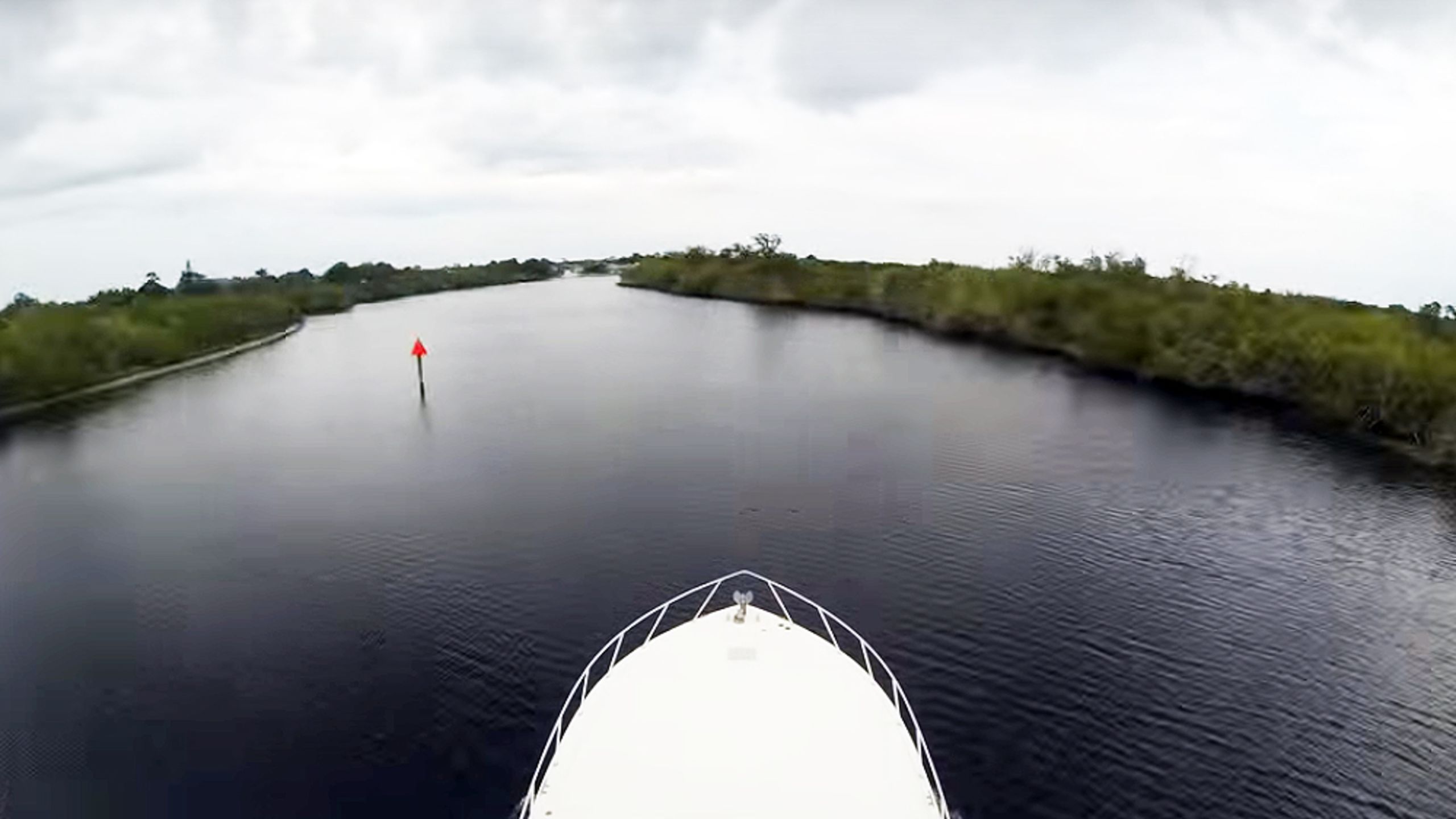
Here's that video
we promised:
Covering 130 miles and 16 hours of continuous shooting starting at mile
100 of the Okeechobee waterway, a go pro time lapse of the
Caloosahatchee River, Lake Okeechobee, St. Lucie River, Hobe Sound and
the lights of Palm Beach.
Shot aboard Nyati, a 52' Viking convertible
on its way to the Viking Yachts Shipyard
This article is part of an Arctic in Context series featuring
Winter 2017 Arctic Research Fellows from the International Policy
Institute, in the Henry M. Jackson School at the University of
Washington. This Arctic research program is dedicated to improving the
transfer of research and expertise between higher education and the
policy world in the area of global affairs.
“It seemed truly like the ending of a world.
Seabirds were dying by
the thousands in the muck.
Vast stocks of salmon and herring and halibut
would perish next.”
This description in National Geographic
of the 1989 Exxon Valdez oil spill is meant to be dramatic.
As we’ve
seen time and time again, oil spills have devastating impacts on the
environment, wildlife, and local communities, and the effects linger
long after the cleanup crews have gone home.
Today, as melting sea ice makes oil more accessible, the risk of a
spill is moving north into Arctic territories.
While a major oil spill
has yet to occur in the Arctic, the Arctic Council began to look
seriously at oil spill prevention and recovery after the 2010 Deepwater
Horizon spill—the largest marine oil spill in history—which the United
States failed to stop from gushing into the Gulf of Mexico and was
unable to clean up entirely.
If this type of spill were to occur in the
Arctic, the lack of major nearby ports and unforgiving weather would
make response much more difficult, not to mention the devastation to a
delicate and already stressed ecosystem.
The Arctic may hold up to 13 percent
of the world’s untapped oil, but due to its fragile and dangerous
environment, the U.S. and Canada both placed a moratorium on new oil
leases in the region in December 2016.
However, under the Trump
administration, oil allies Rex Tillerson and Scott Pruitt may influence
the decision to lift the ban on oil drilling
in the Arctic.
Fortunately, some preventative measures have been taken
by Arctic states.
To avoid an Arctic oil spill and to formulate a
response plan in the event that one occurs, the Arctic Council and its
eight member states signed the legally binding Agreement on Cooperation on Marine Oil Pollution, Preparedness and Response in the Arctic in 2013.
Three polar bears approach the starboard bow of the submarine USS Honolulu while it is surfaced 450km (280 miles) from the North Pole.
Sighted by a lookout from the bridge of the submarine, the bears investigated the boat for almost two hours before leaving.
(U. S. Navy Photo by Chief Yeoman Alphonso Braggs)
But even with this agreement, is the U.S. ready for an Arctic oil spill?
The agreement is meant to enable cross-border sharing of knowledge,
resources, and equipment to assist in the cleanup of large-scale
disasters.
Rarely do we see preventative policies enacted before a major
disaster, especially on an international scale.
The agreement states
that each country must identify areas of special ecological significance
that may be at risk, have appropriate equipment ready to be deployed,
and determine who in the government can request international assistance
and who in other countries can respond to such requests in a timely
manner.
The agreement also stipulates that in an emergency, regulatory
barriers to shipping across borders must be removed—a direct response to
the issues that arose after Deepwater Horizon.
But perhaps most
practically, countries are advised to carry out joint exercises to
improve the ability of responders to work together.
In the Arctic, where
limited knowledge about the behavior of oil in an icy environment makes
the potential effects of a spill difficult to predict, practice is
especially important.
The United States ratified the agreement in 2016, a noteworthy
accomplishment given the challenge of ratifying international pacts in
Congress.
A cleanup worker walks through the oily surf at Naked Island on Prince William Sound on April 2, 1989, a week after the beginning of the oil disaster that occurred when the tanker Exxon Valdez ran aground and spilled 11 million gallons (42 million liters) of crude oil off Alaska, near the oil pipeline tanker terminal in Valdez Harbor.
AFP / Chris Wilkins
The first joint exercise with Canada occurred in 2015 before
the ratification, solidifying the relevance of the international Arctic
Council agreement in U.S. domestic law.
The United States has also
identified sensitive areas, participated in additional joint scenarios,
and ensured oil spill equipment is available.
But although the country
has made progress, the 2014 consensus from the National Research Council
(NRC) and other organizations is that Washington is not fully prepared
for the all the unknowns that come along with an Arctic oil spill.
To Buck Parker, a member of the U.S. delegation that helped draft the Arctic Council’s agreement, one of the largest issues
with the Deepwater Horizon incident was the United States’ difficulty
accepting help from other countries.
While other countries offered
resources and equipment to stop the spill and work on cleanup, questions
arose about whether these offers would violate U.S. coastal shipping
laws.
France, for example, offered oil dispersants that are not approved
for use in the U.S.
This specifically raised concerns about the Jones Act on international shipping and whether this law was hindering the United States’ ability to accept aid for oil spill cleanup.
Part of this coordination must be directed at gathering more
information about what an oil spill in the Arctic would entail.
The NRC report’s
recommendations reflect the Arctic Council’s push for joint exercises,
and it advises that experiments with spilling oil in the Arctic will be
necessary to better understand how oil behaves in cold and icy
environments.
Further, mapping and monitoring of the Arctic Ocean need
to be improved: Updating nautical charts, mapping the coastlines and
seafloor topography, and collecting other data could be vital for ships
to efficiently respond to a spill.
Research from the NRC shows that
increased U.S. Coast Guard presence would allow for a faster response to
a spill given the remote location of the Arctic.
It is unclear under
the Trump administration whether the Coast Guard budget would allow for
an increased presence.
Shell's drilling rig Kulluk ran aground in the Arctic in 2012, and the company abandoned exploratory drilling in the region in 2015 after finding little oil or gas.
Credit: Staff Sgt Aaron M. Johnson/U.S. Air Force
As of now, the closest U.S. Coast Guard station
to the Arctic is in Kodiak, Alaska, more than 900 air miles and 2,000
nautical miles away, a trip lasting about five to six days.
The Arctic Council’s agreement has laid the foundation for
cooperative environmental action, but if the Arctic nations truly want
to protect the already fragile ecosystem of the High North and the
people who call it home, this is only the start.
Given the lack of
infrastructure, unpreparedness for response, and lack of knowledge about
oil in icy environments, a spill in the Arctic today would likely be
worse than the Deepwater Horizon incident.
The Arctic Council needs to
build on the agreement and nations must follow through on their
commitments before drilling begins again.
While U.S. and Canadian
legislation has closed the opportunity for new lease sales and drilling
in the Arctic, the risk remains.
The cost of preventing and preparing
for a disaster is a small price to pay when compared with the cost of a
large oil spill and its long-lasting, catastrophic ramifications.
Ghosts of the Arctic was the type of passion project that my boyhood dreams were made of. Our goal was to venture out into the beautiful frozen expanse of Svalbard, in winter, to search and document polar bears. During the shoot we experienced temperatures that were never warmer than -20ºC and frequently plummeted down as low as -30ºC + wind chill factor. Many days we drove over two hundred kilometres on our snow mobiles in very difficult terrain and conditions as we searched for wildlife.
The bumpy terrain left us battered, bruised and sore.
We experienced three cases of first and second degree frostbite during the filming as well as a lot of failed equipment and equipment difficulties as a result of the extreme cold.
Each day involved 14-16 hours in the field. We had batteries that would loose their charge in mere minutes, drones that wouldn't power up and fly, cameras that wouldn't turn on, steady-cams that would not remain steady, HDMI cables that became brittle and snapped in the cold, frozen audio equipment, broken LCD mounts, broken down snow mobiles and more. We existed on a diet of freeze dried cod and pasta washed down with tepid coffee and the occasional frozen mars bar. But in spite of the conditions, it was one of the most rewarding shoots we have all been involved in. We hope you enjoy it!


