Saturday, December 26, 2020

Ineos Team UK stunning start in race eight | America's Cup World Series | Day 2

In Race 8 of the PRADA ACWS Auckland, INEOS TEAM UK dominated Emirates Team New Zealand in the start.
The 36th America's Cup presented by Prada will be contested by the winner of the 2017 America's Cup, the Royal New Zealand Yacht Squadron represented by their team, Emirates Team New Zealand, and the winner of the Prada Cup, the challenger selection series which takes place in January–February in 2021.

Friday, December 25, 2020

Mariana Trench the life challenges at the deepest sea floor 10km below water level

The Mariana Trench or Marianas Trench is located in the western Pacific Ocean about 200 kilometres (124 mi) east of the Mariana Islands; it is the deepest oceanic trench on Earth.
It is crescent-shaped and measures about 2,550 km (1,580 mi) in length and 69 km (43 mi) in width.
The maximum known depth is 10,984 metres (36,037 ft) (± 25 metres [82 ft]) (6.825 miles) at the southern end of a small slot-shaped valley in its floor known as the Challenger Deep.However, some unrepeated measurements place the deepest portion at 11,034 metres (36,201 ft).
If Mount Everest were placed into the trench at this point, its peak would still be under water by more than two kilometres (1.2 mi).

Thursday, December 24, 2020

Brazil (DHN) layer update in the GeoGarage platform


127 nautical raster charts updated & 4 new charts added

Satellites reveal gaping holes in MOL’s latest explanation for Wakashio crash

MOL's explanation leave more questions unanswered
SOPA IMAGES/LIGHTROCKET VIA GETTY IMAGES
 

From Forbes by Nighan Degnarain

On Friday December 18, operator of the Wakashio put out an explanation for why they believed the large bulk carrier ran aground on the coral reefs of Mauritius.
This was issued by the CEO of MOL, Junichiro Ikeda in Tokyo.

However, the statement appears to be full of half-truths and misdirection.
It could have been taken straight from the Boeing 737 Max playbook, where the captain and crew of two aircraft crashes were initially blamed, before the entire fleet of 737 Max aircraft were grounded for over a year after a software failure (called MCAS) was discovered that had been implemented by Boeing BA -0.2%themselves without informing the crew.
This ended up being the root cause of the Boeing 737 Max safety incidents, that ended up costing Boeing over $20 billion.


Coming on the back of revelations that there were dangerous flawswith the VLSFO fuel that was powering the Wakashio, it raises even more serious questions about what MOL knew about the grounding.

Could the Wakashio have been grappling with engine difficulties due to faulty VLSFO fuel, and a poorly functioning communication system on the Wakashio (which MOL should have picked up on), resulting in the vessel attempting to pass by Mauritius for emergency reasons to alert Tokyo about the engine difficulties they were experiencing?

New satellite analysis by UK-based satellite analytics firm, Geollect, is shining more light on MOL’s statements and the final movements of the Wakashio.
MOL not taking health and environmental consequences seriously enough

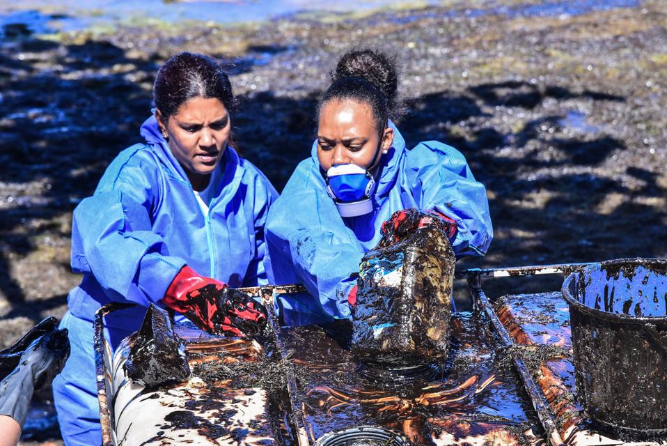
Volunteers from Mauritius were heavily exposed to the toxic fumes and chemicals from the experimental VLSFO fuel on the Wakashio and are now complaining of health complications that MOL have not investigated
L'Express Maurice/AFP via Getty Images
  
At the same time, MOL also do not appear to be taking the health and environment concerns in Mauritius seriously enough given the tens of thousands of Mauritians who have been exposed to what has been shown to be cancer-causing chemicals of a highly defective ‘Frankenstein Fuel’ called VLSFO (Very Low Sulfur Fuel Oil).

There has also been serious concerns with the vitally important, once a year coral reproduction in the region that appears to have been seriously disrupted this year by the leak of VLSFO fuel.

 
The fuel powering the Wakashio was already discovered to have caused major engine failures around the world
Degnarain

There is an urgent need to understand the chemical composition of the VLSFO ‘Frankenstein Fuel’ so the best medical care can be delivered to Mauritius, and the appropriate techniques used to remediate the natural environment (the Wakashio spilled oil into Mauritius’ most important network of coastal natural reserves).
MOL had purchased the fuel, and should have provided transparency on the chemical composition of what the population had been exposed to.
MOL’s repeated attempts to explain why and how the Wakashio was grounded

Mauritians have been marching on the streets in protest against how the oil spill has been handled.
Such marches are rare in the tourist driven country
AFP via Getty Images

Friday’s statement was the third attempt by MOL and the Panama Authorities (where the ship was registered) to offer an explanation for the grounding.
After a brief description on Friday that barely scratched the surface of what caused the worst ecological disaster in Mauritius’ history, MOL dove into a laundry list of actions.
However, what is concerning is that their actions are not linked to the root causes of Wakashio disaster, meaning further risks could still be present across MOL’s fleets.
This could result in that MOL’s ‘Measures to prevent reoccurrence’ not actually prevent reoccurrence by not addressing the ongoing systemic risks that are continuing within MOL’s operations.

MOL has not mentioned any work taking place to extract the audio from the ship's 'Black Box,' Voyage Data Recorder VDR
AFP via Getty Images

Neither does MOL address some serious omissions, such as why MOL - as the world’s second largest shipping company - has not yet released or offered assistance with other leading Government authorities to extract the audio from the ship’s black box (Voyage Data Recorder) or even release the Captain’s ‘Noon Reports’ to better understand the circumstances surrounding the grounding.
The MOL CEO’s explanation of the grounding without using these two critical and additional pieces of data appears to be a serious shortcoming.

It comes ahead of a Court Hearing in Mauritius to decide the fate of the Captain of the Wakashio, due on Tuesday 22 December.

What MOL said and the further questions raised

MOL made four key statements about the cause of the grounding on Friday.
These statements all raise even further questions. 

1. Change in direction

MOL has not given a clear enough explanation for how the change to the voyage plan occurred and the reason for this
 L'Express Maurice/AFP via Getty Images

MOL Statement on 18 December: “Two days before the grounding of Wakashio (July 23), she changed her passage plan-the distance from the coast when sailing off the island of Mauritius-from 22 nautical miles to 5 nautical miles.”

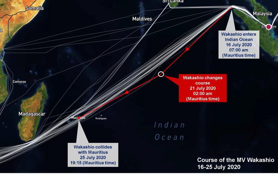
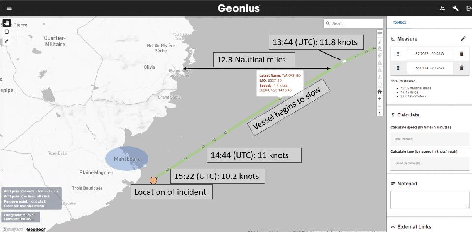
Questions about this statement: Satellite analysis reveals that the Wakashio was on a direct collision course with Mauritius, heading directly for the town of Mahebourg.
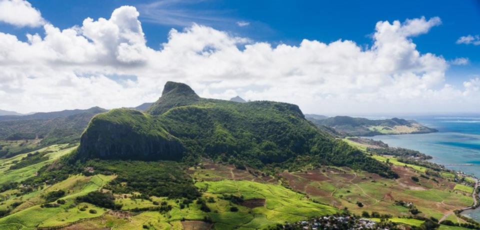
It is hard to reconcile the statement that the Wakashio had adjusted from 22 miles offshore to 5 miles offshore when the trajectory shows it heading straight toward one of the largest mountains in South East Mauritius (the local landmark known as Lion Mountain).
How is this explained?

Satellite analysis from Geollect reveals the Wakashio was heading directly for the town of Mahebourg, and the entire coastline of Mauritius (including large mountains) would have been visible for hours given the sunset time
GEOLLECT

What was most notable about MOL’s first statement was that it appeared to miss out the most important change in direction that occurred on 21 July (see associated satellite analysis), two days before the July 23 adjustment in trajectory.


Satellite analysis reveals the more significant change of direction occurred on 21 July. Why hasn't MOL disclosed the reason for this change in course? Who wrote the Voyage Plan and who was monitoring against this? WINDWARD
 
This was the 13 degree change that put the Wakashio directly on a collision course for Mauritius.
The adjustment on July 23 was a much smaller course adjustment than the 21 July change.
What caused the change in course on 21 July at 2am Mauritius time?
Who wrote that in the Voyage Plan, and who was supervising the voyage plan from MOL’s perspective?
 
 
The turn on 21 July 2020 was much more significant than the adjustment MOL has focused on on 23 July 2020
SATELLITE ANALYSIS: WINDWARD

Why were neither of these changes in direction (on 21 July or 23 July) flagged in MOL’s Safe Operation Support System(called SOSC, which acts as a shipping ‘Mission Control’)? Moving from 22 miles offshore to 5 miles offshore is material from a safety perspective.
MOL has claimed its SOSC ‘Mission Control’ was the key tool that the company used to keep almost 1000 chartered and owned megaships and coastal communities safe.
Yet it appeared that there was serious failures with its SOSC.
Was there a failure in the SOSC system so that it did not detect a deviation from the Voyage Plan of this magnitude?

There are questions whether MOL's SOSC Mission Control was run effectively
MOL

More fundamentally, was there a process for a ship’s Voyage Plan to be automatically uploaded and tracked? Today’s technologies from companies like Geollect, Windward, BlkSails can track vessel movements in near real-time, deviations to within several meters, and long distance trajectories across oceans taking into account weather and currents.
Companies like Uber UBER +3.8%, Lyft LYFT -0.8%, Google GOOG -0.9% and Apple AAPL +2.8% (with their Maps products) track trillions of datapoints every second.
Even basic cybersecurity tools would have detected deviations from a Voyage Plan and flagged this automatically for MOL.
Was this a case of MOL not investing in any serious capabilities or processes in its Safe Operation Support Center, which as a result, is creating greater risks for MOL’s entire fleet? Given the reliance and high profile focus MOL has placed on its SOSC over the past decade, it is surprising that there was no explanation for any systemic failures here in MOL CEO Junichiro Ikeda’s explanation on Friday.

2. Explanation for what happened on the day of the grounding

 
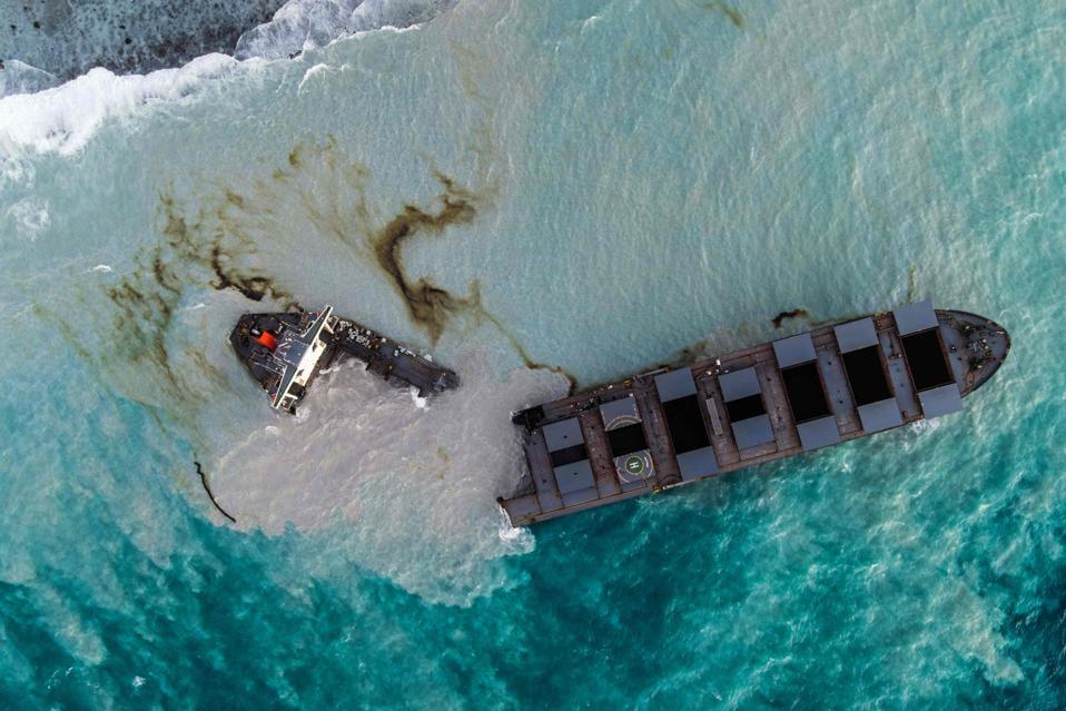
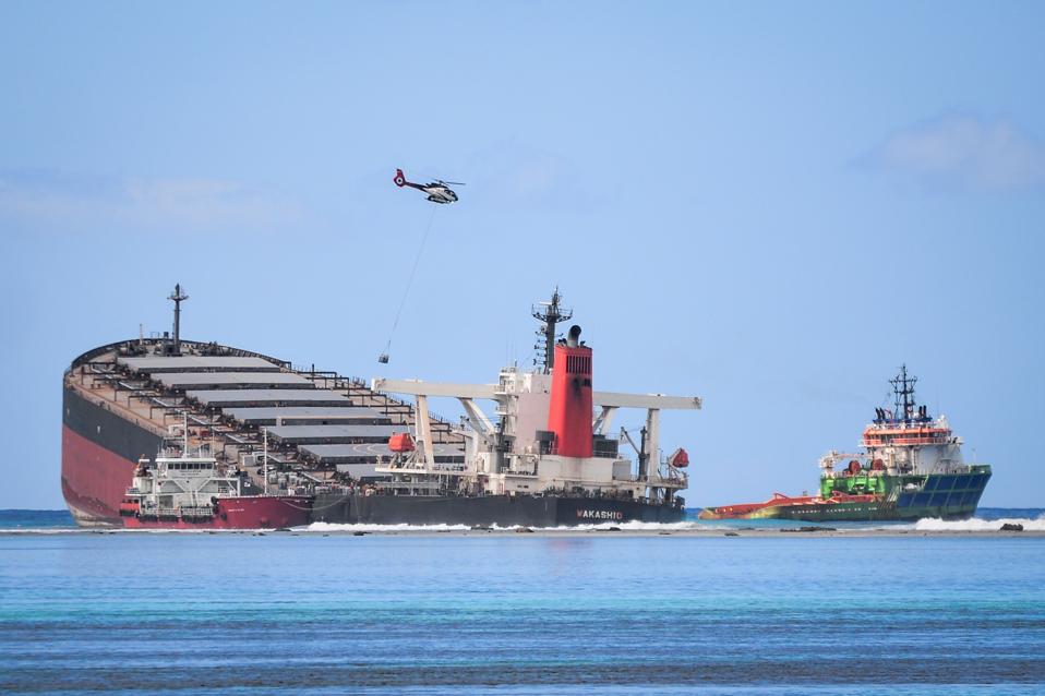
17 Aug: the Wakashio was one of the largest ships in the sea when it crashed into Mauritius' reefs L'EXPRESS MAURICE/AFP VIA GETTY IMAGES

MOL Statement on 18 December: “On the day of grounding (July 25), she tried to further reduce the distance from the coast from 5 nautical miles to 2 nautical miles, to enter an area within the communication range of mobile phones and used a nautical chart without sufficient scale to confirm the accurate distance from the coast and water depth.
In addition, a crewmember neglected appropriate watch-keeping (visually and by radar), even though she was trying to sail 2 nautical miles off the coast.
As a result, she ran aground in shallow water (10m deep) 0.9 nautical miles off the coast of Mauritius.”

Questions about this statement:

Satellite analysis by Geollect reveal the Wakashio was on trajectory for Mahebourg, and not for five ...
GEOLLECT

Satellite analysis does not support this explanation.
From Geollect’s analysis, the Wakashio was heading straight into the center of Mauritius on a direct collision course with the town of Mahebourg.
The Wakashio was not on a trajectory to pass 5 nautical miles South, and did not appear to narrow this distance to 2 nautical miles.
How is this explained?

The area where the Wakashio grounded was notable for its hills and mountains, such as Lion Mountain ...
ROBERT FITZJOHN
 
MOL’s statement only talks about one crew member neglecting watch-keeping, but according to company watchkeeping protocols, there should have been two crew on watch.
This is defined in the vessel’s Safety Management System, a formal document that is part of international maritime law (SOLAS and ISM).
There should have been two crew on bridge watch, so why did the MOL assessment on Friday only talk about one crew neglecting watch-keeping?
The Wakashio ran aground as the sun was setting.
This means that it would have been apparent for several hours that the Wakashio was heading straight into Lion Mountain (a prominent mountain in the region close to the grounding).
How long was this crew member distracted?
What happened to the other crew member who should also have been on the watch?

MOL's fleet should have had access to internet satellite through Inmarsat GETTY

Another notable point is the earlier narrative about the search for ‘internet’ has now changed to a search for placing the vessel within ‘communication range of mobile phones.’ This raises a more serious question whether MOL was aware that there were communication issues on board the vessel, given the importance of internet connectivity in the midst of the COVID-19 crisis and MOL’s commitment last year to provide free internet to its vessels (which is assumed to also mean vessels operated and chartered by MOL, not just owned by MOL, especially during the pandemic).
In response to questions from Forbes on October 6, MOL had said about internet connectivity provision for its vessels, “Again there are no restrictions and is not charged.
Access to certain Apps depends on the region, but is not restricted by MOL.
Training on social media and cyber security take place when crew are ashore.” MOL’s statement on Friday does not shed any more light about why the crew were unable to effectively communicate from the Wakashio.
The Coastguard in Mauritius also reported difficulty trying to communicate with the Wakashio via VHF frequency, revealing several serious systemic communication errors across various onboard technologies, which MOL did not share any information about on Friday.

3. Historical behavior

 
The Wakashio split into two on 15 August, having run aground on July 25.
AFP VIA GETTY IMAGES
 
MOL Statement on 18 December: “Because of not only the above-mentioned background, but also the fact that she had approached to other coasts several times even before the incident, they may have taken unsafe behaviors due to overconfidence that stems from complacency.
In MOL's view, such behavior on a large vessel reflects a lack of safety awareness.”

Questions about this statement:
 
The Wakashio's entire voyage history can be tracked via satellite.
MOL did not list the incidents ...
[+] WINDWARD
 
This was one of the most confusing messages from the CEO of MOL.
The communique did not specify which coasts the Wakashio had been close to previously, and whether this was a decision by the same captain, previous captain, the Wakashio itself, and why this was not flagged on MOL’s Safe Operations Support System.
Was there a communication systems issue with the Wakashio that had not been addressed and the crew had been attempting to find other ways to communicate?
The bridge of the Wakashio is still on Mauritius’ reefs, so these systems can still be assessed.
 
More systematically, was MOL unable to detect this pattern in captains on vessels that MOL operates? This is what an artificial intelligence linked to an Operational Mission Control can do that companies like Geollect, Windward, and BlkSails have been providing to fleets around the world.
It would be a serious oversight if MOL had been unable to performance manage key personnel such as captains and track hazardous incidents in their past.
With around 1000 megaships in its fleets, captains are the critical personnel that keeps MOL’s entire business operation afloat.
It is highly surprising that any performance issue of MOL’s Captains were not being tracked.
 
For a company with $14 billion a year revenue, is MOL investing sufficiently in safety and technology to ensure safe shipping for its global fleets?
 
4. Issues with the navigation equipment

The Wakashio continued to leak oil into Mauritius' coral lagoons even after splitting into two
AFP VIA GETTY IMAGES

MOL Statement on 18 December: “Another reason behind the cause is that the crewmembers lacked awareness of the guidelines on performing navigation in a safe manner and their efforts to conform were insufficient, because they did not prepare an appropriate passage plan that would have ensured appropriate performance, did not own and use the correct nautical map, and neglected visual and radar watchkeeping.”

Questions about this statement:
A vessel’s SMS (Safety Management System) defines the culture and standard operating procedures that should be followed on board a vessel.
Was the issue that the SMS was poorly defined? Was there training provided to the crew to understand the SMS and how to perform a safe navigation? Changing trajectory of a vessel is an important decision, so it is surprising that there were not regular training provided about the SMS.
Had MOL’s procedures for informing its SOSC changed for how crew should inform Tokyo of a change in trajectory? According to MOL’s own documentation, there should have been a regular tracking of every vessel against agreed-upon Voyage Plans.

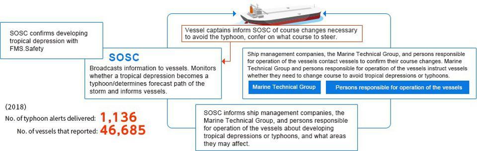
MOL's 'Mission Control' should have been tracking all vessels in its fleet using artificial ...
[+]MOL


This statement also raises questions about the ship’s Electronic Navigation System (called ECDIS).
MOL’s statement refers to incorrect use of the map.
However, since 2012, all vessels require electronic maps.
Wakashio’s navigation systems have had a history of being faulty and picked up in inspections that have identified almost 100 flawswith the Wakashio (a surprisingly high number).

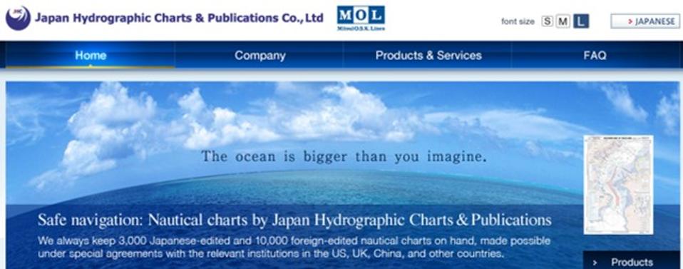
Who was the Wakashio’s Map Provider?

Who provided the faulty map on the Wakashio? There are 40 ECDIS providers, with their own hardware and software.
MOL has a large map company itself.
On September 24, Forbes asked MOL whether they provided the map on the Wakashio.
MOL diverted all questions to Nagashiki Shipping, who declined to comment.

It should be noted that MOL and Nagashiki Shipping have a very close working relationship, so it is unclear why MOL would not disclose which map system was being used, given how critical it is to understand how the Wakashio disaster occurred and to prevent a similar incident from happening again.
 
MOL has one of Japan's largest electronic map providers used for ship navigation.
Was the map system on the Wakashio provided by MOL ?
JAPAN HYDROGRAPHIC CHARTS AND PUBLICATIONS
  
MOL has only discussed the proximate causes and has not once shown any depth or sophistication to understand the systemic risks that led to the Wakashio’s grounding.

For a ship operator that runs over 1000 vessels, that is concerning.

Incidents like the Wakashio should never be allowed to happen again, and this means a thorough investigation and full transparency into the root causes of the grounding and oil spill.


Big questions that MOL has left unanswered

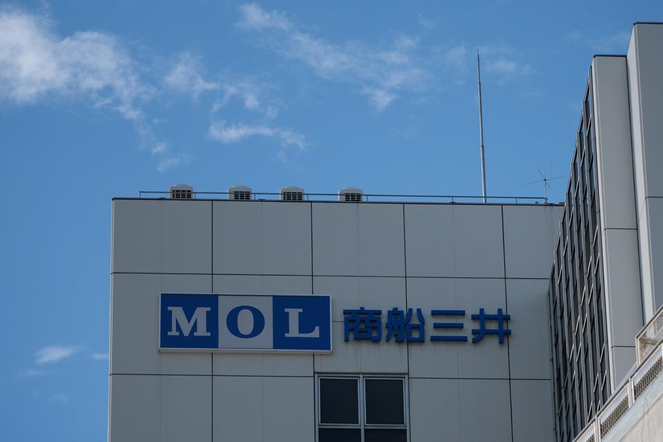
The logo of Mitsui OSK Lines is displayed on the company's headquarters in Tokyo AFP VIA GETTY IMAGES

MOL has also repeatedly fail to answer key questions put to it to understand the cause of the grounding of the Wakashio.

For example:

1. Who was responsible for planning the route that the Wakashio took?
2. Who was tracking the movement of the Wakashio from MOL?
3. How many inspections did MOL conduct over the past 12 months of their fleet of over 800 vessels?
4. How many inspectors does MOL employ?
5. How many vessels were inspected?
6. How many of these vessels were MOL-owned vessels and how many were MOL-chartered vessels?
7. How many times had the Wakashio been inspected by MOL’s inspectors?
8. When did MOL last conduct an inspection of the Wakashio?
9. What was the outcome of that inspection?
10. Given the difficulty the Mauritian Police are having extracting audible voices from the Wakashio’s Voyage Data Recorder (VDR), should MOL not have assisted Mauritius to engage a specialist like the US NTSB to conduct a forensic analysis of the VDR?
11. When can the investigation conduct and publish a full digital forensic analysis of the ECDIS system, to understand the systems used (hardware, software and map system), and whether it could have been compromised? This also includes a full audit of the training of the crew who were responsible for using the ECDIS system, including who provided the training and certified them.
12. Given the description of the search for connection to phone signal was mentioned by MOL, has a full cyber-security audit been carried out on the vessel, including communication systems (satellite internet, VHF, and internal wifi), information technology systems, cyber security systems as well as training of crew in appropriate cyber security protocols?
13. Why hasn’t MOL revealed anything about the effect of COVID-19 on the crew, given that two crew were on board for over a year, in breach of the ILO and Panama’s regulations of 11 months?

MOL’s evolving explanations

 
Why did the crew of the Wakashio not have access to satellite internet services, such as by ...
[+] GETTY IMAGES

Friday’s statement by the CEO of MOL was yet another attempted explanation by officials for the grounding of the Wakashio.

So far, the following explanations have been heard.
Bad Weather Theory: On August 9, MOL’s Head of Safety (responsible for the 24 hour monitoring SOSC station) had claimed bad weather was to blame for the Wakashio.
Panama Authorities (where the ship is registered) then echoed this on August 12, despite no adverse weather showing up by satellite providers.
Internet Theory: On September 8, Panama Authorities had claimed it was a search for internet connectivity that was the cause for the change in direction.
However, that raised questions about whether the communication systems on the Wakashio was working and the services offered by MOL to the Wakashio as operator of the vessel for the long journey to and from Brazil.
Friday’s account has changed language to focus on ‘communication range of mobile phones,’ without revealing whether that was the intention.
Wrong Charts Theory: On September 8, Panama Authorities had revealed that the wrong electronic charts were being used with the wrong scales.
Yet MOL has not disclosed information about who provided the charts, the training of the crew on the Electronic Chart (ECDIS) system or the hardware and software that was being used on board.
Alcohol Theory: On September 12, the Mauritian lawyer of the Wakashio’s Captain revealed that he had been approached by a crew member who had been contacted him and appeared to be under pressure to mention alcohol as a factor or not in the grounding.
This would have raised serious questions about MOL’s alcohol prevention strategy following the Nippon Maruincident in 2018.
Was defective fuel and a faulty engine to blame?


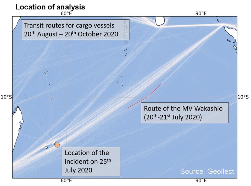
Satellite analysis by UK-based Geollect reveals a steady decline in the speed of the Wakashio's ...
[+] GEOLLECT
 
Satellite analysis by UK-based satellite analytic company, Geollect is revealing new information about Wakashio’s performance.
The key question was what drove the decision to adjust course on 21 July to head toward Mauritius?

Geollect’s analysis reveals that over a period of eight hours, the engine speed of the Wakashio slowed down by 15% over 8 hours.
This was a systematic decline.
Could this have been an indicator that there was a fault on board with the fuel or the engine? It was soon after this decline in speed that the Wakashio made the dramatic 13 degree change of direction toward Mauritius.

This could be indicative of the following reasons, all of which could be driven by having faulty fuel on board.

1. Clogged filters.
If faulty VLSFO had caused the filters to be blocked (as VLSFO has now been shown to do in certain instances), this could have led to exhausts not functioning effectively, an increase in pressure in the cylinder heads and less compression.
All of which would lead to a gradual slow down of the engine.
This would have been noticeable and just 12 days from Singapore on such a long journey to Brazil, the captain may have been attempting to communicate with Tokyo to indicate the problems they were seeing with the engine and fuel.

2. Fuel injector issues.
If the Wakashio was poorly maintained (almost 100 flaws had been identified in its history, which is abnormally high), this could mean issues with how fuel is injected into the engine.
They could have lost pressure, leading to a gradual slow down of the engine.
VLSFO had been shown to have several flow issues due to the chemical properties with how the fuel was made.

3. Lubricant issues.
VLSFO has been associated with greater volumes of lubricants needed.
These additional lubricants have caused further problems with ship engines.
Without appropriate lubricants, this could lead to overheating if the moving parts cause more friction along the sides of the cylinders.
This overheating due to incorrect use of lubricants could lead to the gradual poor performance of the engine.

4. ‘Runaway engine.’ VLSFO is associated with faulty, cracked and broken piston rings.
Piston rings are critical to keep the piston air tight and flowing quickly and smoothly in an engine’s cylinder.
A faulty piston ring could lead to a range of potentially adverse outcomes.
One of those potentially adverse outcomes is a ‘runaway engine.’ This is when fuel and combustion takes place uncontrollably, and the crew may be powerless to take action until the fuel gradually wears down, slowing the engine somewhat.

These are the sorts of explanations that MOL should have been focusing on, with a full set of evidence, not a misdirection about the slight navigation adjustment on July 23.
Geollect conducted a detailed analysis of the turn of the Wakashio on July 20-21
GEOLLECT

 As the inquiry goes on into the Wakashio, a more transparent and trusted working relationship would have helped build understanding with both the shipping industry and MOL.

However, the approach taken continues to caused economic, social and political uncertainty to Mauritius, and the MOL CEO’s latest statement does not appear to role model the trusted and transparent leadership being called for. 
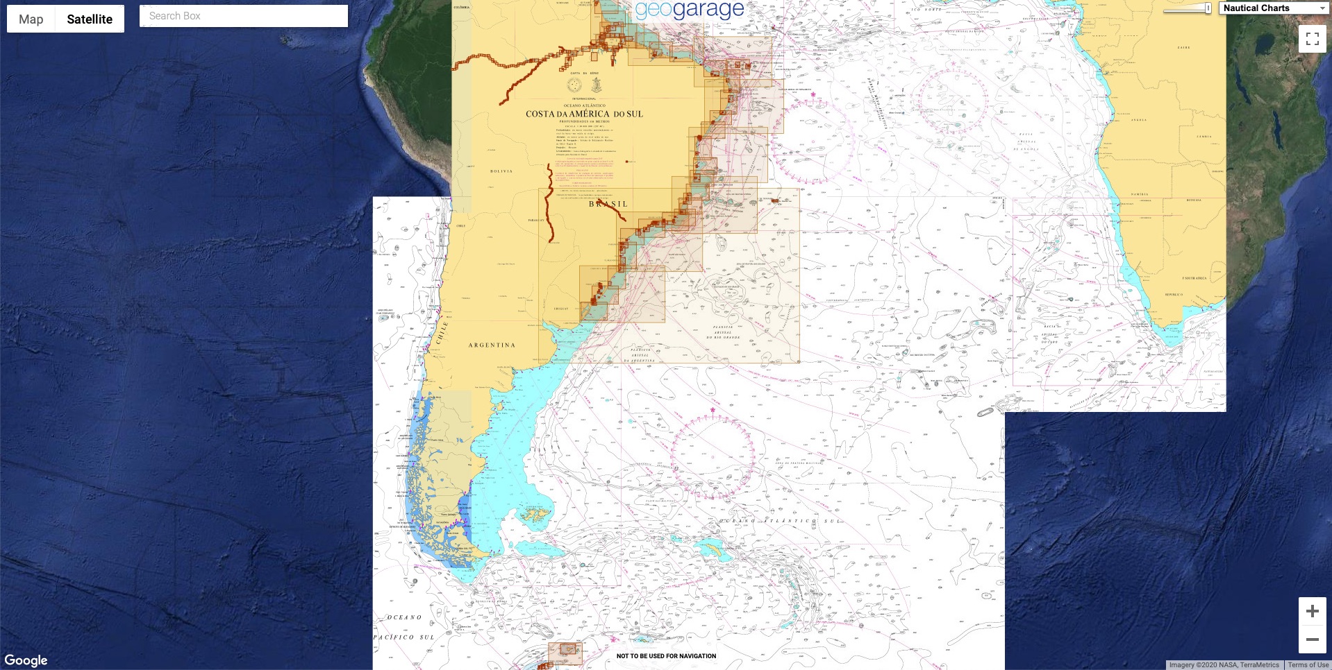
Links : 

Wednesday, December 23, 2020

Why the U.K. and EU are fighting over fish

Domicile of vessel with the greatest fishing intensity in 2016
Source: Global Fishing Watch

From Bloomberg by Hayley Warren and Ian Wishart

After nine months, the U.K.’s trade talks with the European Union came down to the rights of fishing boats from EU countries to catch in British waters.
Both sides want to keep fish flowing across borders and avoid clashes between ships at sea, and the EU wants to maintain its access to waters vital to its commercial fishing industries for years to come.

“On fisheries the discussion is still very difficult,” said European Commission President Ursula von der Leyen to the European Parliament.
“In all honesty it sometimes feels that we will not be able to resolve this question.”

While a member of the EU, the U.K. had to divide up its waters as part of the Common Fisheries Policy.
But the British have long said this unfairly restricted its own industry.
The EU didn’t question the U.K.’s right to control its seas but insisted that, in return for a trade deal and access to the bloc’s single market, it should continue to give vessels from countries like France, Netherlands and Belgium a large share of the catch.

This video shows fishing effort (as time at location over 3 months) estimated by Global Fishing Watch in selected Marine Protected Areas in the UK Exclusive economic Zone around Scotland from 2012 to 2020.

Shared Waters
 
The talks focused on what’s called the Exclusive Economic Zone, the sea between 12 and as much as 200 nautical miles from the British coast.
A section between 6 and 12 miles also formed part of the discussion because European vessels, particularly those from France, have had access there for centuries, although it didn’t formally come under EU jurisdiction.

There are some precedents for countries outside the EU having agreements on fisheries with the bloc.
The EU has bilateral arrangements with Norway and the Faroe Islands, for example, in order to jointly manage fish stocks and allow European fishermen to work in their waters.

Norway reached a bilateral framework agreement on fisheries cooperation with the U.K.
in September.
The country, which has a free-trade deal with the EU as part of its membership of the European Economic Area, has said it may close its waters to fishing vessels from the European Union and the U.K. on Jan. 1 if a deal between the three parties isn’t concluded by the end of the month.

The EU’s Common Fisheries Policy, which sets out catch limitations for each country, was established to address the steep decline in fish stocks in the world’s fourth largest fish producing area, and the world’s highest in value.

EU fisheries ministers set limits, known as the total allowable catch, for each species, on an annual basis in negotiations that often last well into the night.
The idea is that each country should receive a fixed share over a long period of time.
The catch limits are revised each year and can be traded.

Catch Limits

The U.K. shares valuable North Sea fish stock allowances with EU neighbors

Other species
Note: Catch limits for zones IVa, IVb, IVc.
Share of catch based on available data.
Sources: European Commission, Global Fishing Watch
 
The U.K. wanted to change the way fish stocks were calculated to use a formula called “zonal attachment,” which the government said gave a much more accurate picture of where fish are now, rather than the EU’s model based on data from the 1970s.

The EU opposed Britain’s efforts to make access and quota numbers dependent on annual negotiations because it said that would damage the stability of the European industry.

According to officials close to the negotiations, the U.K. on Friday rejected an EU offer that would see the bloc lose around 25% of the current 650 million euros ($795 million) of fish caught annually in British waters.
The U.K. is pushing the reduction to be closer to 60%, according to the officials who spoke on condition of anonymity.

To put that into context, the negotiations are snagged over fishing rights equivalent to about 0.1% of U.K. gross domestic product.
The British government’s own analysis in 2018 suggested the economy will be at least 2.6% smaller in 15 years’ time if there’s no trade deal.

Links :

Tuesday, December 22, 2020

Rugged connectivity: Lessons learned from high-end racing

Electronics play a key role in crossing the finish line first, especially when dealing with ever-changing wind and wave conditions.
Fischer Connectors is an official supplier of fiber optic connects for NYYC American Magic
© Amory Ross / NYYC American Magic

From Sail-World by Stuart Doe


High-end racing, whether on land or water, is notorious for its secrecy.
With the Prada Cup and America's Cup races in 2021, no one working with any of the hyper-competitive teams would dare give away those secrets.

Spoiler alert: This isn't about secrets.
Even though Fischer Connectors is the exclusive connectivity sponsor of American Magic - a challenger for the 36th America's Cup - and has provided connectors and solutions for many racing yachts over the past five decades, we can't give away any of our trusted partners' competitive secrets.
This article is about the lessons learned working on various racing yachts over time, and how some of the latest connector technology and strategies used in racing can be applied to other real-world applications.

Racing into 2021


From the moment the America's Cup AC75 class rule was first published on March 29, 2018 by the current America's Cup Defender, Emirates Team New Zealand, challenger teams have been designing and engineering their boats within the set rules to give them every possible edge in a temperamental racing environment.
In fact, American Magic spent over 76,000 man hours producing its first AC75, DEFIANT.

So, what are the stats for an AC75?

Length: 22.76 m
Width: 5 m
Weight 6.4 tons
Crew: 11
Crew weight: 990 kilos
Construction: carbon fiber and double-skinned soft mainsails
Construction hours: 76,000+
Design hours: 90,000+
CNC machine and/or 3D printing hours: 45,000
Individual parts: 25,000
Sensors: 400+

All of this development comes at a significant cost to the teams entering the America's Cup.
To put this into context, the last event in 2017, held in Bermuda and won by Emirates Team New Zealand, is believed to have cost upwards of USD 100 million, with some teams reporting that they had to pay twice this figure to actually become competitive for the Cup.

Races can be won or lost in the design, construction, and/or operational phases.
Even fractions of seconds are of critical importance in a race for the America's Cup and for the pride of a nation.
Despite huge R&D budgets, it's ultimately the team of 11 sailors working as one in precise harmony that determines who'll be the winners on race day.
So, the engineering teams do everything they can to give their sailors the advantage.


Racing yachts such as the UK Team Ineos' "Britannia" are estimated to have over 300 sensors on board to help guide sailors by giving race teams real-time data on changing conditions.
-photo © Chris Ison

Lesson One: Sensors Create Real-Time Data for Immediate Decision Making

Sailors and their support teams operating in high-pressure situations have to deal with many more variables than, say, the driver of a "simple" NASCAR vehicle.
Wind speed and direction, water movement, water temperature, hull angle and foil position are all variables in yacht racing that can not only affect each vessel differently, but also change constantly during the race.
Sensors are everywhere on the boat, from the foils to the wingsail, gathering data that enable sailors to calculate and use them to their advantage.
Additionally, sensors help to adjust strategies or tactics in a fraction of a second if they get the right information at the opportune moment.

Given the strict weight criteria for such a "flying machine", designers and engineers are constantly deliberating over each component used on the vessel: Will it deliver during practice, during the race, once or over time? Is it rugged enough? Is it too heavy? Is it really needed?

The Importance of Interconnect Solutions

Reliability in both the sensors and connector solutions is essential.
Maintainability is critical, as is IP (Ingress Protection) sealing and the ability to withstand saltwater ingress and spray.

Elevated temperatures are also a challenge to connector solutions, as most electronics are stored (and operated) in sealed airless compartments and may be exposed to extreme solar heating.
Indeed, a black carbon panel can easily reach above 70 degreesC in the UK sunshine - let alone in New Zealand! This places significant duress on the reliability and functionality of the electronics enclosed within.

Fiber Optic Plays an Important Role

One area of great interest beyond the use of conventional copper wired interconnect solutions is the use of fiber optics for data transmission.
In the America's Cup in 2017, fiber optic sensors were embedded in the race boat foils and in other key components.
This allowed the team to measure, analyze, predict and optimize the design of the parts, while keeping stress levels under control.
If set correctly, the foil offers both lift and drag, similar to an aircraft wing in flight.

"The electronics and data acquisition on an America's Cup yacht such as American Magic's Patriot are absolutely crucial to our success," says Antoine Sigg, Fiber Optic, American Magic.
"Loads of data streams are processed constantly, feed models, trigger alarms and help the sailor to make adjustments for wind, attitude and stresses on the boat.
It's essential that the connectivity solution delivers accurate data.
The fiber optic solutions from Fischer Connectors help us have simple and reliable connections to many key zones on the boat, especially where lines are connected and disconnected daily.
They link the boat system to moving parts, and the robustness of the Fischer FiberOptic Series is used at its full potential to withstand shocks, fast movements and exposure to the elements in a firehose-like environment."


Fiber optic sensors embedded in race boat foils can be used to measure the lift, drag and horizontal force generated by the foil in real time.
- photo © Epsilon Optics


In a racing yacht, the foil rake and angle of attack are adjusted for different points of sailing (upwind and downwind) and different wind strengths.
Getting real-time information from the sensors through fiber optic connections allows optimization of the foil angle and load, providing the appropriate lift for any given displacement and wind condition.

This was demonstrated to greatest effect in the 2019 Sail GP event in Cowes on the UK's Isle of Wight.
There Tom Slingsby's Australian Team utilized the foils in a completely different mode than any competitor, sailing three races with the bow firmly down, reducing the rudder loads, and maintaining control in winds of over 25 knots.
The result was three straight wins over the remaining international competitors.


Catamarans in previous America's Cup races may not have been the first to utilize "big data" during competitive sailing for real-time and post-race analysis, but they pushed ideas that led to today's electronics designs.
- photo © Stuart Doe


Fiber optic devices tend to be smaller and lighter than conventional copper.
The cable is essentially a glass tube less than 2 mm in diameter that propagates data using light energy, which is converted into an electrical signal at the destination source.
In essence, data speeds move in near perfect conditions within the tube, resulting in the highest data transfer rates, without loss or low delay.

Another advantage of fiber optics is the ability to physically embed these miniature single-strand sensors into the laminated carbon structures of the boat, without affecting the structural integrity of the foil or mast/wing section or the functionality of the hardware.
These embedded sensors also ensure you can monitor potential breakages of such highly stressed parts of the boat at all times and avoid them if at all possible.
Clearly, these items are very asset-sensitive due to cost, material and build time; hence only the most appropriate cabling and connector systems can help ensure longevity and avoid delays in this challenging environment.

A final significant benefit for the AC75 is the weight advantage offered by this type of fiber optic.
When considering electronics control systems on board boats, it's fair to assume most yachts carry in excess of 60 kg of wire for their control and instrumentation circuits.
This weight can be greatly reduced if traditional copper is replaced with state-of-the-art, high-capability fiber.

Data as a Commodity


As reported by Martin Whitmarsh, CEO of Land Rover BAR, with all this live real-time data from in excess of 400 sensors per boat*, it's a veritable treasure trove of data.
It's essential that adequate data connection, onward transmission, storage and subsequent analysis be performed for all modes of sailing and conditions.
As a dinghy sailor myself, I consider my surroundings and speed while sailing, just two variables that affect my performance.
For these high-performance racing yachts, however, sailors consider up to an estimated 300 variables simultaneously to evaluate and adjust performance, including water time, flight time, speed, boat position, angle, loads, foils and rudder angle.
To do this perfectly in a race requires gathering, transmitting, analyzing and acting on reliable data.
In 2017, it was estimated that Team Oracle's boat accumulated between 200 GB and 500 GB of data every day.
It's no wonder that so much data crunching is needed to ensure you can optimize the performance of every element for live sailing conditions.
This explains the involvement of companies like database giants Oracle and Dell EMC in the last America's Cup and, more recently, Hewlett Packard for this 2021 campaign.
Clearly, reliable data management ensures the boat performs as competitively as possible and defines a clear configuration setup for each and every condition that the boat is raced in.
Recent reports from the teams out in New Zealand suggest that the typical data now being collected by this year's Cup teams are in excess of 1 billion data entry points.
This makes the data collation and sifting activity a significant contribution to the teams' performance and understanding of the data variables, with significant implications for performance.

Lesson Two: Connected Technology and the Internet of (Boating) Things

To help them race today, every single competitive racing yacht utilizes world-leading engineering and design, Internet of Things (IoT) devices, data analytics and data modeling.


Support vessels and chase boats are also outfitted with communications gear and sensors.
- photo © Amory Ross/ NYYC American Magic


Modern racing boats take full advantage of the IoT, integrating hundreds of sensors taking various measurements - including state-of-the-art sensors for wind measurement, speed and angle, accelerometers, and a significant number of load sensors buried deep within the mast/rig and foil construction.
These load meters are also supported by numerous water-based sensors calculating GPS, depth, turbulence and temperature and, most importantly, speed.
This was shown on the SAIL GP event in 2019, when two methods of boat speed were needed to validate the over 50 Knots (57.5 mph!) achieved by both the Australian and UK teams during this race series.

Ease of accessibility and interconnectivity between these sensors and any instrumentation are critical and, of course, the performance of any marine-based connector must be resistant to water ingress (IP rated) and harsh saltwater corrosion.
As previously mentioned, weight is also a critical performance criterion for any foiling craft, so the provision and support of this technology is often a balance against weight, performance, functionality and cost.

The use of real-time data from these sensors is pivotal to both design measurement simulation and actual optimal performance, thereby allowing both prediction and practice of the fastest method of sailing in pursuit of the Cup.
This is also true of weather measurement, and wind and wave prediction.
If one side of the course is favorable for optimal performance, it's key to identify tactically how and where patterns of wind will be emerging.
This is especially the case in New Zealand, with its interesting harbor course and sheltered racing areas.

It isn't just the racing yachts that are outfitted with a myriad of sensors.
Chase boats and support vessels are deployed prior to the event to survey, mark out and ensure sailing areas are clear of underwater obstructions.
All these vessels use 3D sonar scans and data overlaid on conventional chart plotters, which are updated live via 4G networks.
Teams are increasingly utilizing the higher bandwidth and live-streaming capabilities of 5G that became available with significant infrastructure updates during the end of last year.

The reduced latency and higher bandwidth of 5G means Emirates Team New Zealand is now able to live stream data and video back to engineers and designers at the base straight off the new AC75 boat.
Dan Bernasconi, Head of Design for Emirates Team New Zealand, said in a 2019 Yachts and Yachting interview that the 5G service is a game changer for the team.
"There's a huge amount of innovation in the design and build of the AC75.
The boat is a completely new concept, so we need to be able to push the potential of this boat to its extreme in testing," Bernasconi commented.
Prompt onward data transmission in all areas is critical for the teams to support live monitoring and performance enhancement.

Broadcast-Quality Communications on Every Boat

Transmitting information to the base team for their use is a given, but racing organizations also make technical information available worldwide, broadcasting on multiple platforms and applications, even to devices carried in a spectator's hand.


The American Magic team reviews data from a practice session.
- photo © Amory Ross


The sailing world first saw the production of stadium-style racing introduced in the late 1990s.
These boats, like those competing for the 2021 America's Cup, were live-streaming on-board video and telemetry data, along with audio, directly to audiences.
With ever more information and data from the boats now being displayed live to audiences through traditional broadcasts, interactive apps and across the Web, etc., the races come even closer to those on spectator boats or on shore.
All cases require robust and secure connectivity boat-to-boat and boat-to-shore to facilitate this.

Lesson Three: Innovation and the Connected Team

With enormous budgets on these boats, even for high-end racing, it's clear that every team is pushing the frontiers of technology, science, innovation and performance of the boat and the crew.
That's only what we know about now, not what's being kept secret!

In years gone by, the crew was there to provide power to drive the winches for sail movement and trim.
While this is still the case to some degree, there's also a small amount of battery support topped up by the crew grinders.

Crew role, weight and performance output have now become critical.
This means, in addition to data gathered from the boat itself, there's now far more interest in the biographical data from the crew itself, along with individual communication and data sharing on board the boats.
Years ago, wind noise was not an issue for the sailors, who now travel at speeds in excess of 60 mph.
Specialist headsets and microphones had to be generated to allow interconnected radios among the team members.
Buoyancy aids now hold radios, batteries and multiple interconnects between buoyancy aid and headsets.

Each sailor is effectively a network-connected worker and, with today's technology, it's possible to monitor individual heart rates, biometrics, temperature and performance of the entire team.
Such monitoring manages the physical elements of the sailing team and adjusts and optimizes for peak performance during the critical race season.


This life-vest-wearing mannequin was on display at CES 2020, sporting AC75 buoyancy aid fitted with HD Camera with 1080P 30FP/S and Fischer LP360™ connectors.
- photo © Stuart Doe/Fischer Connectors


Applying the Lessons

The key to applying the lessons of high-end racing to other, less dynamic, industrial or instrumentation applications is to understand the impact of the data you need.
Not everyone needs 400 sensors, but when you do, it's important to have a connectivity strategy that delivers the data in meaningful, actionable ways.

Consider how much data you need to be able to move and how fast it needs to travel.
Use the Internet and analytical tools, including artificial intelligence (AI), to make faster decisions that push you forward.
Remove unnecessary weight while increasing data transmission with fiber optic solutions.
If IoT strategies and technology are available to racing yachts, then they can be available to any application, anywhere.

Ultimately, engineers looking for a solution may be seen to be competing, whether it's against their actual competition, or simply because the application being designed is a challenging puzzle that needs to be solved with the best, most efficient design.
My advice as a sailor: When you need to stay competitive, strive for excellence and aim to be the first across the finish line.
However that finish line is defined, always remember the fun of the race.

Links :

Monday, December 21, 2020

Underwater tunnels revolutionize the Faroes

An incredible underwater roundabout is set to open in the remote Faroe Islands.
The Eysturoyar tunnel network is almost 7 miles long and runs beneath Skálafjørður fjord, connecting the islands of Streymoy and Eysturoy.
The tunnel network and its undersea roundabout will significantly cut journey times to the Faroe Islands’ capital Torshavn from many locations, according to contractor NCC.
The tunnel, for example, will shorten the journey time from Torshavn and the village of Runavik from just over 34 miles to 10.5 miles, according to Estunlar, which is overseeing the project.
The lowest point of the tunnel is 613.5 feet below sea level.
Work on the tunnel began in 2016.
"The Eysturoy tunnel is planned to open the 19 of December 2020," Teitur Samuelsen, CEO of Estunlar, told Fox News, via email.
"It has a spectacular roundabout under the Atlantic Ocean. It will be decorated by the famous Faroese artist Trondur Patursson, with a ring of people dancing the traditional Faroese dance."
The stunning underwater traffic circle has been attracting plenty of attention on social media.
“The first roundabout under the Atlantic Ocean is a reality,” tweeted Kristina Hafoss, a member of the Faroe Islands Parliament.
“This is part of our new 11 km sub-sea tunnel connecting 2 of our 18 #FaroeIslands in a new & innovative way.”
“Not a new lair for Dr Evil but a new 6.8 mile underwater tunnel network with roundabout connecting two of the Faroe Islands, Streymoy & Eysturoy!” tweeted Wallasey Yacht Club in the U.K.
In another project, construction is also underway on the Sandoyar tunnel, which will be almost as long as the Eysturoyar tunnel when it is completed in 2023.
The two tunnels are the largest infrastructure investment in Faroe Islands history, according to NCC. Located in the North Atlantic, the Faroe Islands are a self-governing nation within the kingdom of Denmark.
 
From CNN 

Underneath the North Atlantic Ocean lies a series of sub-aquatic tunnels, connecting the rugged islands that comprise the northerly Faroe Islands archipelago.

Localization with theGeoGarage platform (DGA nautical raster chart)


 The soon to be opened Eysturoy tunnel network has already caused a splash, thanks to newly released photos of its center point -- a striking new underwater traffic circle: illuminated, turquoise-blue and some 187 meters under the sea.

The lights, colors and ethereal design makes the structure look otherworldly.
The 11-kilometer-long tunnel will likely be a welcome development for locals, shortening the 64-minute drive from Tórshavn -- the capital of the Faroes -- on the isle Streymoy, to the hubs of Runavík and Strendur, on the isle of Eysturoy, to just 16 minutes.
And for tourists, the dazzling traffic circle could become yet another reason to visit this Danish autonomous territory, already known for beautiful scenery and wildlife.

Symbolic significance

 
The traffic circle was designed by local artist Trondur Patursson, pictured.
Courtesy faroephoto.com

The traffic circle, located at the center of the tunnel network, was designed by local artist Trondur Patursson.

It's made of natural rock, just like the wider tunnel network.

The colors regularly change from blue, yellow and green and the lights dance, creating an dazzling effect.
Teitur Samuelsen, the CEO of the company constructing the tunnels, told CNN Travel that, for Patursson, the illuminated structure symbolizes the moving from the darkness towards the light -- and also recalls the traditional Faroese chain dance, in which people hold hands and link up together in rings.

This seems appropriate, given the tunnel network also serves as a means of connection.


The striking structure has symbolic significance.
Courtesy faroephoto.com

Samuelsen said that he believes the traffic circle to be the only one in existence under the North Atlantic Ocean.
The Eysturoy Tunnel will open on December 19, 2020 and it'll be followed in a few years time by the still-in-construction Sandoy Tunnel, which will link Streymoy to the isle of Sandoy.

Links :

Sunday, December 20, 2020

Around Cape Horn (1929)

Capt. Irving Johnson's valiant voyage around Cape Horn.
Captain Irving Johnson sailed aboard the bark "Peking" in 1929, as the sun set on the day of commercial sail.
During his voyage on the big German windjammer, Johnson compiled unequaled footage of the crew's daily activities, and spectacular images of a wild storm as the ship made the dangerous passage around. Johnson's narration of the trip is a delight