In October 2019 the Marshall Islands Marine Resources Authority (MIMRA) set out on a Pacific Islander-led expedition to two of the Republic of the Marshall Islands' (RMI) most remote atolls, Bikar and Bokak.
The goal of the expedition was to conduct the country's first ecological assessment of these atolls, which will serve as baseline data for future resource management decisions.
Bikar & Bokak atolls in the GeoGarage platform (NGA nautical raster charts)
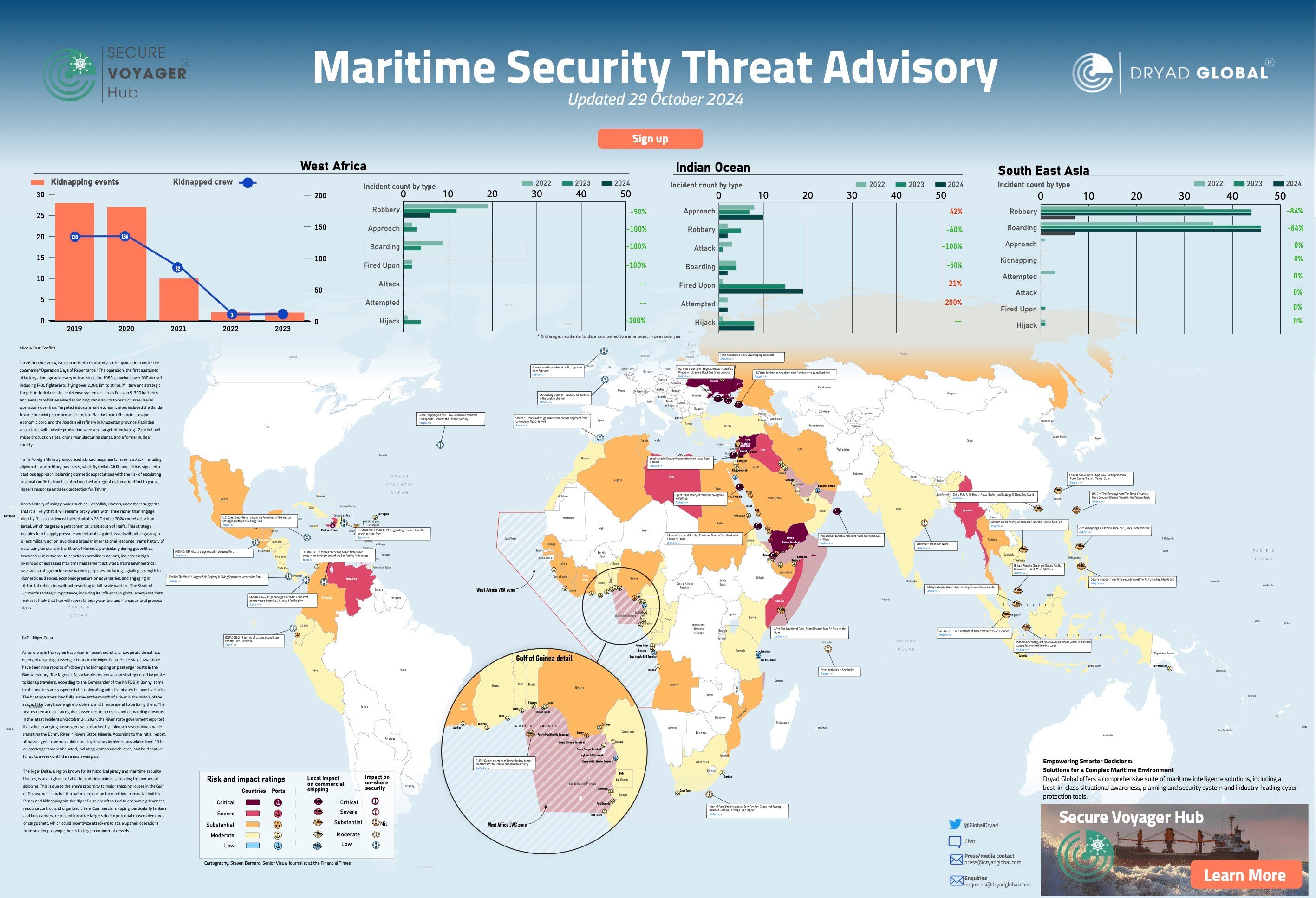
The landscape of maritime security is increasingly shaped by technological advancements and evolving global threats.
As international trade relies heavily on shipping, securing vessels, ports, and shipping routes has become a more intricate challenge. This complexity is heightened by the growing risks posed by cyber threats and piracy, both of which demand adaptive security strategies and innovative technologies to protect the maritime sector.
The maritime industry’s journey into the digital age began in the 1990s with the introduction of technologies such as Electronic Chart Display and Information Systems (ECDIS) for navigation. These systems enhanced operational efficiency, but cybersecurity was not a key consideration at the time. As the industry moved away from traditional navigation methods and became increasingly reliant on digital systems, new vulnerabilities began to emerge—though their significance was not fully recognised.
1. WEST AFRICA (GULF OF GUINEA AND NIGER DELTA) Kidnappings and Robberies: In recent months, there has been a resurgence of piracy and kidnapping incidents in the Niger Delta, specifically targeting passenger boats. A worrying tactic has emerged where boat operators allegedly collaborate with pirates, feigning mechanical issues to enable attacks. Ransoms are often demanded, with abducted passengers held captive until paid. Impact on Commercial Shipping: Given its strategic importance, the Gulf of Guinea continues to be a hotspot for maritime crime, impacting commercial vessels, especially tankers and bulk carriers. Increased vigilance is recommended for vessels operating in this region. 2. INDIAN OCEAN AND SOUTHEAST ASIAReduced Incidents, Ongoing Threats: While piracy incidents in the Indian Ocean have decreased, recent reports of armed robbery in Southeast Asia indicate that risks remain. The ReCAAP ISC reported multiple incidents in October 2024, particularly in areas like the Singapore Strait. Collaborative Naval Efforts: Regional navies, including Indonesia and the Philippines, are stepping up patrols to counter these threats, as seen in incidents involving Chinese vessels in disputed waters. 3. MIDDLE EAST TENSIONS AND BLACK SEA CONFLICTIran-Israel Tensions: On October 26, 2024, Israel launched a significant retaliatory strike against Iran under “Operation Days of Repentance,” targeting strategic facilities, including missile and drone manufacturing sites. In response, Iran is likely to increase proxy activities through groups such as Hezbollah, raising concerns about potential attacks on maritime routes in the region. Black Sea Grain Corridor: Russia’s intensifying attacks on Ukraine’s grain exports have heightened risks for vessels in the Black Sea. UK and EU leaders have raised alarms over the safety of maritime routes, urging increased protections for commercial vessels. 4. SOUTHEAST ASIA AND SOUTH CHINA SEAChinese Military Expansion: China’s deployment of anti-stealth radar and surveillance ships in the South China Sea is escalating tensions. With heightened naval exercises and military maneuvers from both the U.S. and allies, the region remains volatile, affecting shipping routes through these contested waters. Piracy in the Sulu-Celebes Sea: Although there have been fewer kidnappings since 2020, concerns persist around organized crime and piracy activities targeting vessels in Southeast Asia, especially near the Philippines and Indonesia.
In the 2000s, as the maritime industry integrated IT systems for cargo tracking and communication, cybersecurity concerns remained largely ignored.
It wasn’t until a significant cyber incident between 2008 and 2010, which involved the hacking of a vessel’s navigation system, that vulnerabilities in onboard digital systems were first exposed.
As cyberattacks grew more sophisticated, targeting shipping companies, port operators, and their employees, the maritime sector remained slow to address the growing threat.
A turning point came in 2017 when the NotPetya ransomware attack severely disrupted operations at global shipping giant Maersk. The attack crippled container shipping, port operations, and logistics, costing the company around $300 million in recovery expenses. In the same year, the WannaCry ransomware attack disrupted transportation networks worldwide. These incidents further revealed the vulnerability of interconnected global trade systems to cyber threats. In response, the International Maritime Organization (IMO) introduced cybersecurity guidelines in 2017 and mandated the inclusion of cybersecurity risk management in Safety Management Systems (SMS) for vessels by 2021.
By the early 2020s, cyberattacks targeting smaller shipping companies were on the rise, highlighting the urgent need for comprehensive cybersecurity measures throughout the maritime industry. With ports serving as critical links in the global supply chain, securing their digital infrastructure also became a key priority.
Rear Admiral (Rtd.) David W. Titley, a recognized expert in maritime security, has been outspoken about the intersection of cybersecurity and maritime threats. He emphasizes the growing risks in the maritime industry, noting that the sector has been slow to address these challenges. “Digital advancements, like automation and digital navigation, have made ships more vulnerable to cyberattacks, which could disrupt global trade and threaten security,” Titley warns.
While cybersecurity threats have become more prominent, piracy remains a persistent challenge, particularly in high-risk areas like the Gulf of Aden, the Strait of Malacca, and the Gulf of Guinea. Despite significant efforts to combat piracy, it continues to evolve in response to changing regulations and technological advancements.
Lloyd’s Register, a leading maritime risk management firm, highlights the growing risks of cyber piracy, including ransomware, navigation system hacks, and communication disruptions. These threats can cause financial loss, endanger lives, and disrupt global trade. Lloyd’s stresses the importance of robust cybersecurity measures on ships and in ports to mitigate these risks.
The IMO has played a pivotal role in combating piracy through frameworks like the MSC.1/Circ.1333 guidelines, which assist member states in developing national strategies to prevent piracy. Regional cooperation, as seen with Nigeria’s “Deep Blue Project,” has been instrumental in reducing piracy through advanced technology and increased naval patrols. However, piracy continues to evolve, with pirates now employing tactics like drones and autonomous vessels. This evolution calls for updated counter-piracy protocols and enhanced international cooperation. The IMO continues to encourage collaboration and the use of private maritime security contractors to improve safety in high-risk regions.
Rear Admiral Chris Parry (Rtd.) highlights the effectiveness of private maritime security contractors (PMSCs) in reducing piracy, particularly in areas like the Gulf of Aden. However, he emphasizes the need for careful regulation to avoid legal and operational issues, ensuring their deployment complies with international laws and standards.
The advent of autonomous vessels further complicates maritime security. While these vessels promise operational efficiency and reduced human error, they are heavily reliant on digital systems, making them vulnerable to cyberattacks. In response, the IMO has introduced guidelines for the regulation of autonomous vessels, such as the MSC-FAL.1/Circ.3 resolution, focusing on safe operation and adherence to security standards. As autonomous vessels become more widespread, future IMO resolutions will likely evolve to address the cybersecurity and safety challenges they present.
As the maritime industry becomes more interconnected and digitalized, the need for global resilience against both cyber threats and piracy has never been more urgent. The IMO’s MSC.1/Circ.1331 resolution, which seeks to enhance the capabilities of developing countries in addressing maritime security threats, underscores the importance of international cooperation. Strengthening global maritime security will depend on capacity-building, joint exercises, and the development of information-sharing networks.
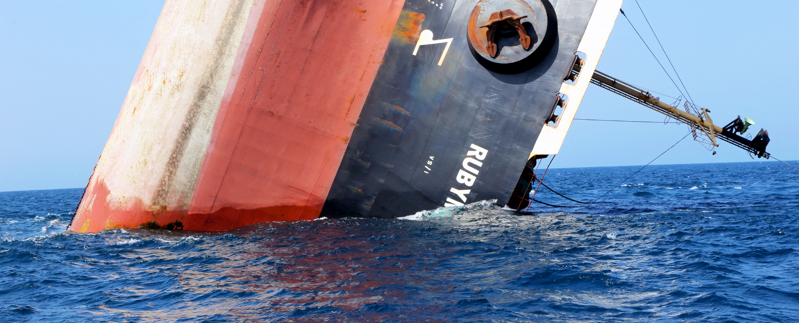
The shipping vessel Rubymar capsizing in the Red Sea after a Houthi missile attack.
(Photo: AFP/Khaled Ziad)
In conclusion, the IMO should consider implementing new resolutions that mandate the inclusion of computer science professionals in maritime curricula, alongside fields like Nautical Science, Marine Engineering, and Electrical Engineering. Cybersecurity professionals onboard play a crucial role in securing vessels’ digital infrastructure as the maritime industry becomes more technology-dependent. Their duties include overseeing IT systems, such as navigation and communication networks, preventing cyberattacks, conducting regular risk assessments, and managing vulnerabilities.
These professionals are also responsible for training the crew on cybersecurity best practices, raising awareness about threats like phishing and malware, and ensuring compliance with international regulations, including those set by the IMO. They work to protect sensitive data, secure communication channels, and collaborate with shore-based teams to ensure that shipboard security aligns with broader organizational policies.
As digitalization advances, the role of cybersecurity professionals in safeguarding shipboard systems, operational data, and sensitive information becomes increasingly vital. The future of maritime security will depend on addressing the dual challenges of cybersecurity and piracy. While digitalization and the rise of autonomous vessels bring new security risks, they also offer innovative solutions. The IMO will remain central in shaping the future of maritime security, ensuring proactive and adaptable regulations to emerging threats. Strong international cooperation, technological advancements, and comprehensive security strategies will be crucial in protecting the critical infrastructure that supports global trade.
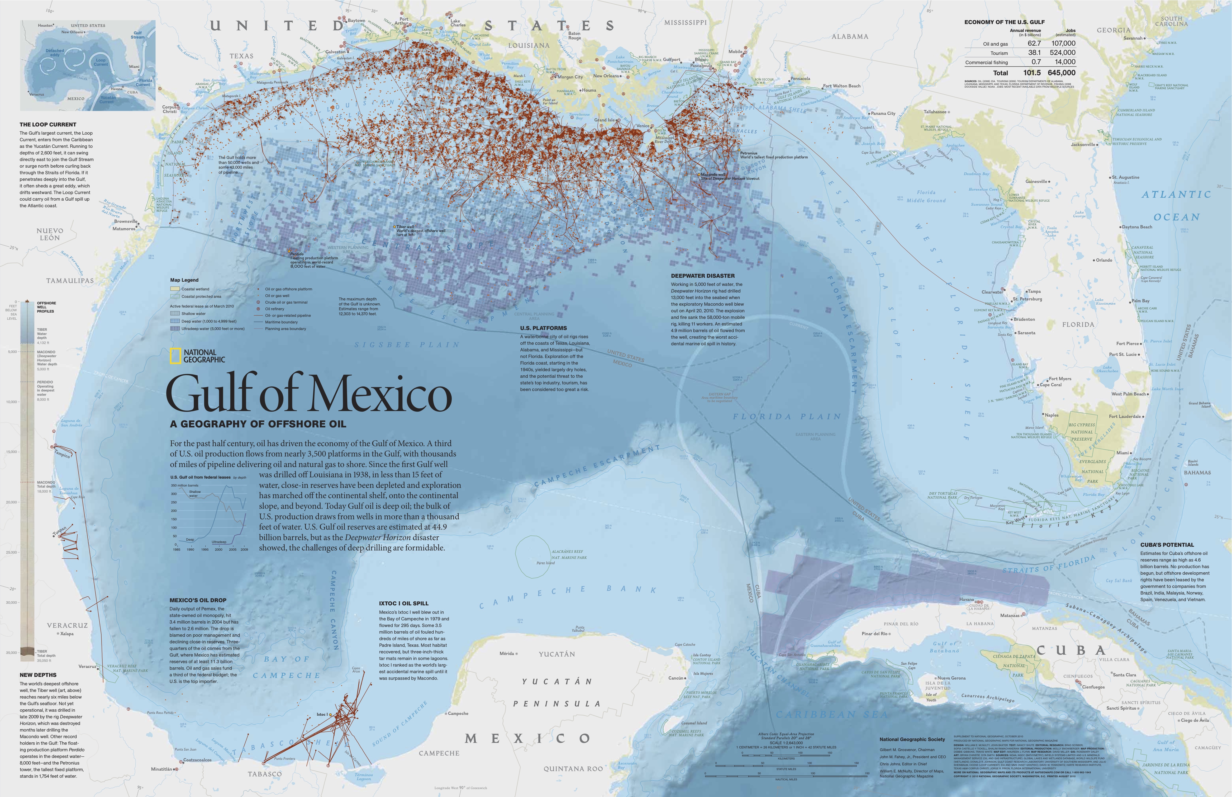
After 2010 Deepwater Horizon incident, some Gulf of Mexico species densities declined as much as 83%
The occurrence of several whale and dolphin species in the Gulf of Mexico drastically dropped off in the decade following the 2010 Deepwater Horizon oil spill. The disaster produced a 149,000-square-kilometer (58,000-square-mile) oil slick and released a substantial amount of dispersed oil under the ocean surface.
Researchers from UC San Diego’s Scripps Institution of Oceanography, along with their colleagues, analyzed acoustic data collected over a 10-year period during and immediately after the spill. To study the deep-diving species that live in the waters affected by the spill, they maintained autonomous listening stations at depths of more than 915 meters (3,000 feet) in the northern Gulf of Mexico. Their findings reveal significant declines in the presence of several species of beaked whales, sperm whales and dolphins. The data, which captured the echolocation clicks and communication signals of a diverse set of marine mammals, documents declines of up to 30% for sperm whales and 80% for beaked whales since the spill.
The study appeared Dec. 21 in the journal Nature Communications Earth and Environment.
Study lead author Kaitlin Frasier, a research oceanographer at Scripps Oceanography, emphasized that while the study shows a strong correlation between the spill and marine mammal declines, it does not prove that the spill caused the drop-off. She highlighted the inherent challenges in proving such a link.
“While predicting exactly where and when a disaster will occur is challenging, advancements in technology and long-term monitoring can help us better understand and address their impacts,” Frasier said. “By focusing on innovative solutions and sustained efforts, we can improve our ability to assess and mitigate the effects of events like oil spills, even in the most challenging offshore environments.”
The spill itself was estimated to have released 210 million gallons of oil, making it the largest marine oil spill in the history of the petroleum industry. This study, like others in the wake of the disaster, was initially funded by a trust fund created as part of the legal settlements following the spill. However, it was the determination of Scripps oceanographer John Hildebrand that made the research possible, said Frasier. Hildebrand secured emergency funding to launch the project during the period of the spill, and pieced together support from various organizations to sustain the effort over a decade, even during periods without dedicated funding.
“The Deepwater Horizon oil spill was an unprecedented disaster that demanded a nationwide response,” said Hildebrand. “We quickly relocated instruments from southern California to the Gulf of Mexico to gather critical data needed to understand the spill’s impact on marine mammals."
Other studies unrelated to this one had previously found rates of infant dolphin deaths in coastal waters were six times higher than normal. A 2015 study led by the NOAA linked the spill to increased deaths of bottlenose dolphins in the gulf. Today, settlement funds remain to assist coastal remediation efforts, but offshore impacts have been difficult to assess.
“Experts predicted minimal effects and recovery within a decade, and there is no evidence that they were correct,” said Frasier. ”Those opinions were used as the basis for the post-spill damage assessment and legal settlement. To me, this says that we still have a lot to learn about the deep ocean and how interconnected everything in it is. Gathering data is irreplaceable, and it is central to the mission of Scripps.”
While some locations outside of the 2010 surface oil slick showed increases in whale and dolphin activity, it remains unclear whether these patterns indicate animals relocating to less impacted regions. Frasier and her colleagues continue to investigate this question using the same High-Frequency Acoustic Recording Packages (HARPs) used in the initial study, now expanded across the entire Gulf of Mexico, including in Mexican waters.
“So far we haven't found evidence suggesting an unexpectedly large number of animals in the western Gulf,” Frasier said. “It's unlikely that the populations simply moved out of the affected area,” Frasier said.
This ongoing research highlights the importance of long-term acoustic monitoring for understanding the impacts of environmental disasters on marine life. By improving our understanding of these impacts, this study will help future researchers estimate damage in remote, offshore habitats, and guide recovery efforts in the event of future environmental disasters, the authors said.
An innovative mission on the Welsh border, funded by an anonymous
private investor, has begun work to create a ‘permanent human
settlement’ under the sea
Down an easy-to-miss turnoff on the A48 just outside Chepstow on the Welsh border, the gentle rumble of trucks, cranes and people at work mixes with birdsong in what is an otherwise peaceful rural setting. It is a crisp and sunny winter morning when I visit and, at first glance, the site appears to be little more than prefab containers and a car park. Yet, behind the scenes a group of men and women with expertise in diving, marine biology, technology, finance, construction and manufacturing are building something extraordinary. They have come together with a single mission statement: to make humans aquatic.
Their project is called Deep (not The Deep) and the site was chosen after a global search for the perfect location to build and test underwater accommodation, which the project founders say will enable them to establish a “permanent human presence” under the sea from 2027. So far, so crazy sounding. Yet Deep is funded by a single anonymous private investor with deep pockets who wants to put hundreds of millions of pounds (if not more) into a project that will “increase understanding of the ocean and its critical role for humanity”, according to a Deep spokesperson. Its leadership team remains tight-lipped not only about the amount (they will only say it is substantially more than the £100m being invested into the Deep campus near Chepstow), but also about the investor’s identity. Whoever is behind it, the size of the investment means that an ambitious-sounding idea appears to be swiftly becoming a reality.
Phil Short, research diving and training lead at Deep, outside the full-scale replica of the subsea sentinel habitat under construction at a site on the Welsh border. Photograph: Mark Griffiths/the Observer
The 20-hectare (50-acre) site in Gloucestershire was once a limestone quarry that was flooded in the 1990s and used by a dive school until 2022. Now, it is being transformed into a state-of-the-art facility that will feature accommodation units, a training school and a platform for mini submersibles to take people down to living spaces in the 80-metre deep (260ft) lake. These underwater units, known as sentinels, will then be used to train scientists – and eventually anyone else who has the money to rent them – to live under the ocean for much longer than has ever been achieved before, and at a greater depth. The goal is to live in the ocean, for ever. To have permanent human settlements in all oceans across the worldMike Shackleford, chief operating officer, Deep
DEEP has announced plans to construct an underwater habitat open to the public by 2027.
Named Sentinel this modular subsea habitat aims to revolutionize underwater living, research, and observation by providing scientists unprecedented access to the depths of the ocean.
The Sentinel system is designed to facilitate extended stays underwater allowing scientists to reside at depths of up to 200 meters for as long as 28 days.
This innovative habitat offers a unique opportunity for researchers to study the continental shelves more comprehensively.
The modular design is flexible enough to support everything from short term missions to semi permanent deployments marking a significant shift in subsea habitation.
The units can be lowered to 200 metres (656ft) under the sea, which is where the sunlight zone ends and the twilight zone of the ocean begins. Marine life found at that depth includes the kind of creatures most people will only ever see via David Attenborough documentaries and is a place about which we still know very little.
Mike Shackleford, Deep’s chief operating officer, explains the thought process behind the project. “Back in the 1950s and 60s, there was a space race and an ocean race going on, and space won out. Space is tough to get to, but once you’re up there, it’s a relatively benign environment.” The ocean is the opposite: it’s fairly easy to get to the bottom, but once you’re down there, “basically, everything wants to kill you”, he jokes.
“Yet, just about every oceanographer I’ve met says, ‘You’d be shocked at how little we know about the ocean’,” Shackleford tells me. “So somebody has got to take those first steps to try to build some of the technology that will allow us to go down and study the ocean in situ.”
The idea of Deep’s sentinels is that, initially, people will be able to stay inside for up to 28 days at a time – though the hope is that this could one day be extended to months … and beyond. “The goal is to live in the ocean, for ever. To have permanent human settlements in all oceans across the world,” says Shackleford.
Jacques Cousteau led a group of ‘aquanauts’ in an underwater habitat in the Red Sea in 1963, proving that such expeditions were possible. Photograph: Robert B Goodman/National Geographic Creative
There have been previous attempts to establish living quarters in the sea. Jacques Cousteau pioneered underwater living in the 1960s, starting with the Continental Shelf (or Conshelf) I, a five-metre long, 2.5-metre wide steel cylinder that was set up off Marseille at a depth of 10 metres. Cousteau went on to develop more sophisticated versions of Conshelf I at locations around the world – funded in part by the French petrochemical industry.
Cousteau eventually abandoned it for a career focused on conservation but underwater habitats remained popular for some time after, inspiring all sorts of experiments, including one by two British teenagers who lived underwater for a week off the coast of Plymouth in a steel tank they had built themselves. The craze to conquer life under the ocean then “dropped off in the 80s”, says Shackleford. “Humanity kind of walked away and went towards outer space.”
Nasa’s Aquarius Reef Base in the Atlantic Ocean in the Florida Keys national marine sanctuary, built in 1986, is still in use. Photograph: J Marshall/Tribaleye Images/Alamy
The last and most sophisticated undersea habitat was the Aquarius Reef Base, five miles off Key Largo in Florida and 19 metres under the surface. Now run by Florida International University, it was built in the 1980s and is the only underwater human habitation still used today, including for the training of Nasa astronauts as part of the space agency’s Extreme Environment Mission Operations’s (Neemo) programme.
Back in Gloucestershire we pile into a Land Rover to begin the bumpy ascent up the track that loops round the lake where, as we near the clearing at the top, we are greeted by shouting, banging and the sound of electric drills. Everything being made by Deep is being constructed either on site or down the road at an industrial unit in Bristol, including the lifesize wooden mock-up of the sentinel that we are driving to see.
‘The perfect location to build and test underwater accommodation’: Deep’s site at a quarry lake in Gloucestershire. Photograph: Richard Varcoe/Deep
The habitat simulator, a full-scale replica of Deep’s subsea human habitat, will be used to train divers on land before they live below the water. Photographs: Mark Griffiths/the Observer
Standing outside the full-size underwater house gives an instant idea of the incredible scale of the undertaking. The main recreational area is a six-metre diameter hemisphere, and the porthole windows mean that when the real thing is submerged there will be an inescapable feeling of being surrounded by the ocean and its inhabitants. Short estimates it will take anywhere between a year and 18 months to get someone who has never dived before fully capable of running an ocean deployed sentinel system
Upstairs is a kitchen and an area that can be adapted to scientific study. The six bedrooms are roomy and there is a fully fitted bathroom with running water and a flush toilet. The whole thing is constructed from a type of steel specially developed to withstand the pressure at 200 metres.
Although no one working on deep-sea submersibles wants to dwell too much on the Titan tragedy – the deep-sea submersible that imploded off the coast of Newfoundland, Canada, in 2023 killing all five people on board – Phil Short, research diving and training lead at Deep, is not surprised it’s a subject that keeps coming up. One of his primary concerns is to underline strongly the difference between this project and that of the Titan.
Deep’s engineers have been working with Det Norske Veritas (DNV), a classification and safety agency, to ensure it is fully tested and certified all the way through the design and manufacturing process. “DNV are approving every potential design, manufacture and testing capability of our systems from day one,” Short says. “So, when we finally get this built and we’re about to drop it in the water, it will be fully certified in class.”
The two-person mini submersible is prepared for deployment at the edge of the lake. Photograph: Richard Varcoe/Deep
Classing is like an MOT on a car, he says: “No one reading this would think of putting their children, their partner, their family dog, in a homemade car with no test, unknown brakes, unknown gearbox, unknown engine and homemade tyres.”
They would, he says, choose something based on how well it will protect those people.
The equipment might be certified, but what about the people who will be using it? It will be a huge task to physically and mentally train those without any experience for life under the water. Even looking at the two-person mini submersible they have waiting for deployment at the edge of the quarry lake, I think, could I really trust it to take me a few metres below the surface of a lake, let alone convince myself to travel hundreds of metres under the sea? Research into the effects of saturation diving on the body in the 1970s and 90s tended to be on young, fit men. To revisit that work with a wider variety of people is going to enable better science
The philosophy behind how successfully an individual will cope, says Short, is much the same as that for training soldiers: you can do as much basic training as possible but until you’re in a firefight you don’t know how you’re going to respond. However, the advantage of having a simulator that pretty much exactly replicates life underwater, means Deep’s dive-training team are better able to put people through their paces.
“We can basically cover that psychological aspect of: how do you feel being stuck in an environment about the size of a small family home with five other people for 28 days? We can trial that thoroughly,” says Short. He estimates it will take anywhere between a year and 18 months to get someone who has never dived before fully capable of running an ocean deployed sentinel system.
Dawn Kernagis is director of scientific research for Deep. We meet in London, at the end of a trip she has taken from her base in the US to see how progress is coming along at Deep campus. Kernagis was a crew member with the Nasa Neemo mission that lived aboard the Aquarius Reef Base and so has rare first-hand experience of living underwater.
“I can still visualise what it was like to wake up in the morning there,” she says. “We had the window just next to the bed and so you would open your eyes and see fish, stingrays and sharks swimming by. Being able to watch those interactions was just so key. Because, you know, we weren’t disturbing their environment, they were just doing their thing and it’s really cool to have the capability to observe that.”
Mini submersibles will take people down to living spaces in the 80m deep (260ft) lake. Photograph: Richard Varcoe/Deep
Deep will offer the same experience but with more sophisticated accommodation, at greater depths, and allow scientists to work at those depths for greater periods of time. Their sentinels will also be able to be redeployed to different places. The idea is that a foundation construction will be attached in the desired location at the required depth and then the sentinels will be lowered down to click into the base like “a ski boot being locked into a ski”, Kernagis says. The basic sentinel houses up to six people but the idea is that multiple sentinels could be attached to potentially form multi-nation, multi-purpose research stations (or perhaps, one day, an underwater village for ordinary people).
In the past, a lot of the early underwater habitats were meant to be redeployable, but it was difficult to do that, so they would be put down in one place and stay there for years. “You’re restricting what marine science you can do if you can only do it from one place,” Kernagis says.
The sentinels will include a kitchen, study area, six bedrooms and fully fitted bathroom
Kernagis, who has a background in human physiology, is excited about being given the ability to learn more about the human body and what living at depth does to it. Much research into the effects of saturation diving on the human body was done in the 1970s and early 1990s but it tended to be on young, physically fit men, she says. The ability to revisit some of that work with a wider variety of people and to do it in situ, rather than potentially compromising samples by bringing them to the surface, is going to enable better science.
Kernagis thinks the relative comfort of the accommodation provided by Deep will help anyone using it. Aquarius, for example, used a bunk-bed system with six people sleeping in one tiny space. “Living under pressure like that, some people tended to snore louder than normal,” she says, “so we tended not to sleep as well.” Then there were the questionable bathroom facilities. “We had a toilet that was actually part of the shower and was in the moon-pool area, which is where you go in and out for your dives. And so everything was just a curtain that you pulled. And that was it.”
Deep’s toilets, a spokesperson assures me, have been through “extensive human factors assessments to ensure that they are as comfortable as possible”.
Across the River Severn from Gloucestershire in a commercial kitchen in Avonmouth, Bristol, chef Joe Costa is trimming carrots to use in the main course of an experimental dish. An underwater menu is one of the final, but crucial, pieces of the puzzle that Deep is working on to make life under the sea the best it can be. They say an army marches on its stomach, so quantity, quality, taste and ease of digestion are all massive factors to make these missions successfulJoe Costa, chef
“The first hurdle was the challenge of actually being able to taste anything at depth because your tastebuds are suppressed by the pressure change,” says Costa, a classically trained chef and a diver.
He is focusing on using strong flavours that will be delivered in vacuum packs. His initial menu sounds mouth-watering and he makes it more tantalising by describing it like he is presenting it on an episode of MasterChef.
“We start with a french onion soup, with nice cheese croutons on the top, and then we have slow roast, short-rib beef that has been marinated for a week in a sous vide (vacuum-sealed bag) in a really heavy red wine sauce. That is served with a truffle polenta with ricotta and then, to finish, a double sticky toffee pudding, which is spiced with extra cinnamon, all spice, and star anise.”
Porthole windows mean those within will be surrounded by ocean life. Photograph: Mark Griffiths/the Observer
Chef Joe Costa’s first attempts at presenting vegetables that are both visually appealing and easy to stow; the dive centre on the full-scale sentinel mock-up. Photographs: Joe Costa; Mark Griffiths/the Observer
If this sounds hugely calorific, it’s because it is. Phil Short, who at 56 boasts an impressively skinny frame, explains that as soon as anyone gets in the water, even if it’s warm, they start losing heat rapidly and their lungs have to work harder against the pressure of the water. This raises the body’s metabolism significantly, and that’s before any physical exertion has taken place. “I’ve spent my whole life in the water and I eat and eat and still lose weight,” he says.
A lot of the food Costa is preparing tastes too strong above the water. The beef in the sauce was wonderfully tender but “hard to palate” he says. Yet at depth it should hit people’s tastebuds in just the right way. And he’s thought of every detail to make a culinary underwater experience the best it can be. “We are thinking about doing sous vide cheese snacks as an appetiser so that when the divers come into the sentinel, they get their wet gear off and get changed and can have a little cheese board before they start their meal.” All that’s missing, it seems, is a glass of red wine.
Once Costa has created the menus they will go to a nutritionist to assess them for the required levels of vitamins and minerals and finally they will be tested under pressure in a laboratory in a diver research centre in Plymouth. Short is unapologetic about the apparent extravagance of the food on offer. “They say an army marches on its stomach, so quantity, quality, taste and also ease of digestion are all massive factors to make these missions successful,” he says. “And, more importantly, for the type of people we want to put in these habitats it makes meals enjoyable, rather than just miserable.”
Deep’s engineers are working to fully test and certify the structure through each stage of the design and manufacturing process. Photograph: Mark Griffiths/the Observer
Everything about Deep – the Gloucestershire campus, the size and scale of the underwater accommodation, the food and the anticipated clientele – appears to be pushing the boundaries of what has gone before. But one thing remains constant, and that is what is waiting in the watery world below for those who brave life in the underwater housing.
“There are going to be things down there that we won’t even know to ask questions about before we descend, because we don’t know yet that they exist,” says Kernagis.
This potential is what makes work under the ocean so exciting for her. She recalls her time towards the end of the mission on the Aquatic Reef Base when she made an excursion with a colleague in one of the submersibles outside the main habitat.
“We were wrapping up some of our sample collections and I made the comment to her that I couldn’t imagine life back on Earth. And she turned to look at me and said, ‘We are on Earth’. But for me it was like I was in this whole other world.”
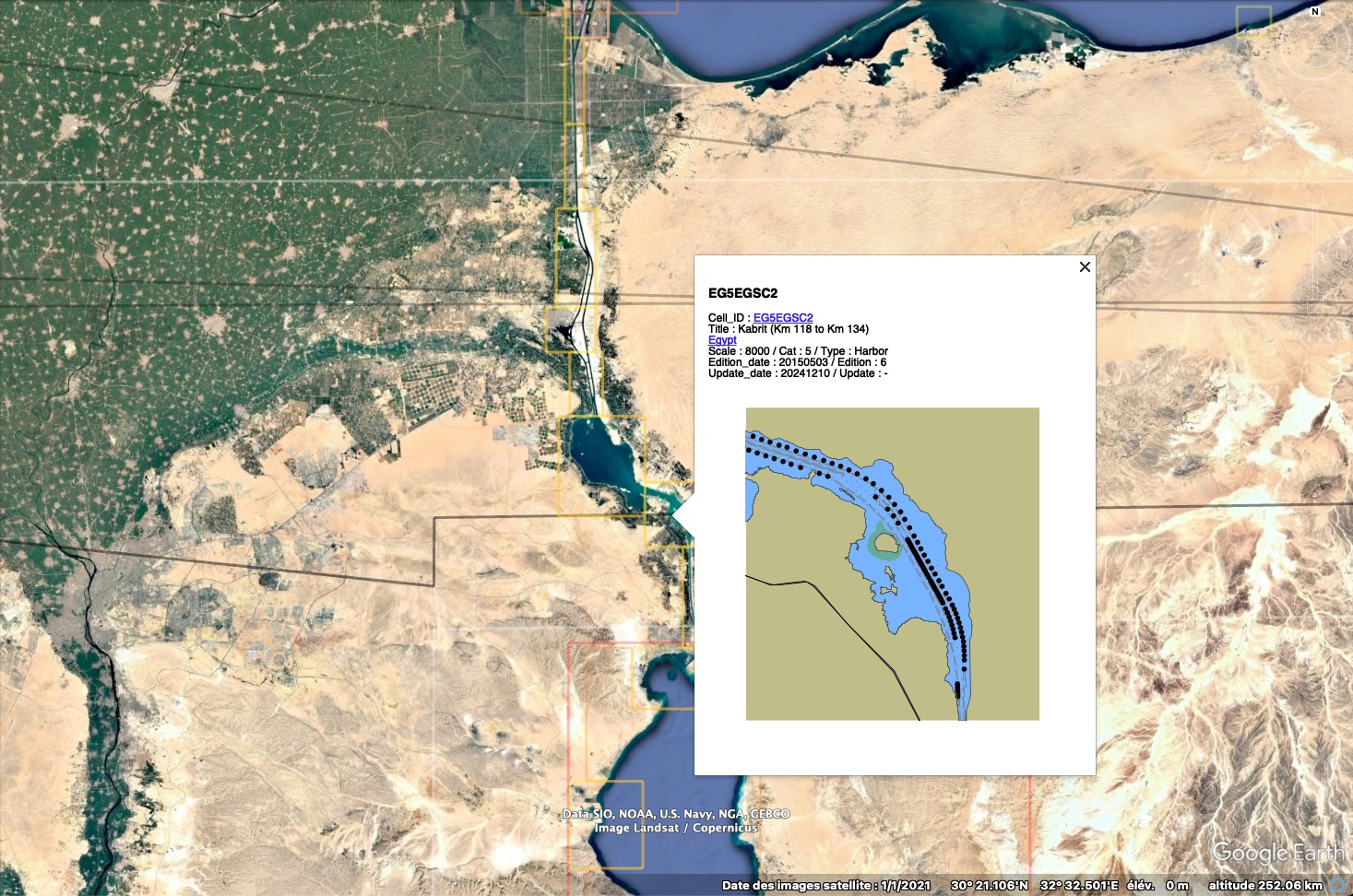
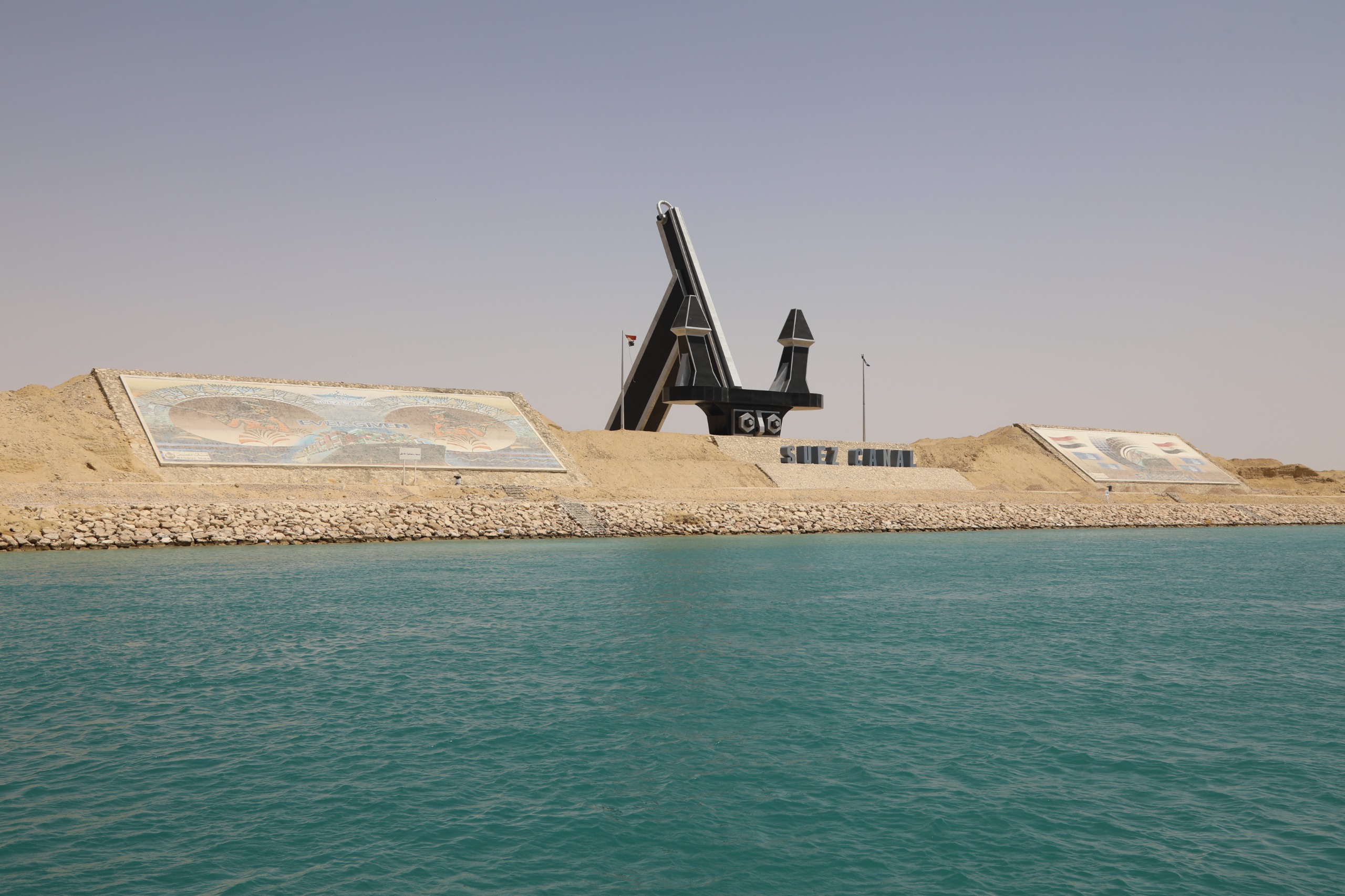
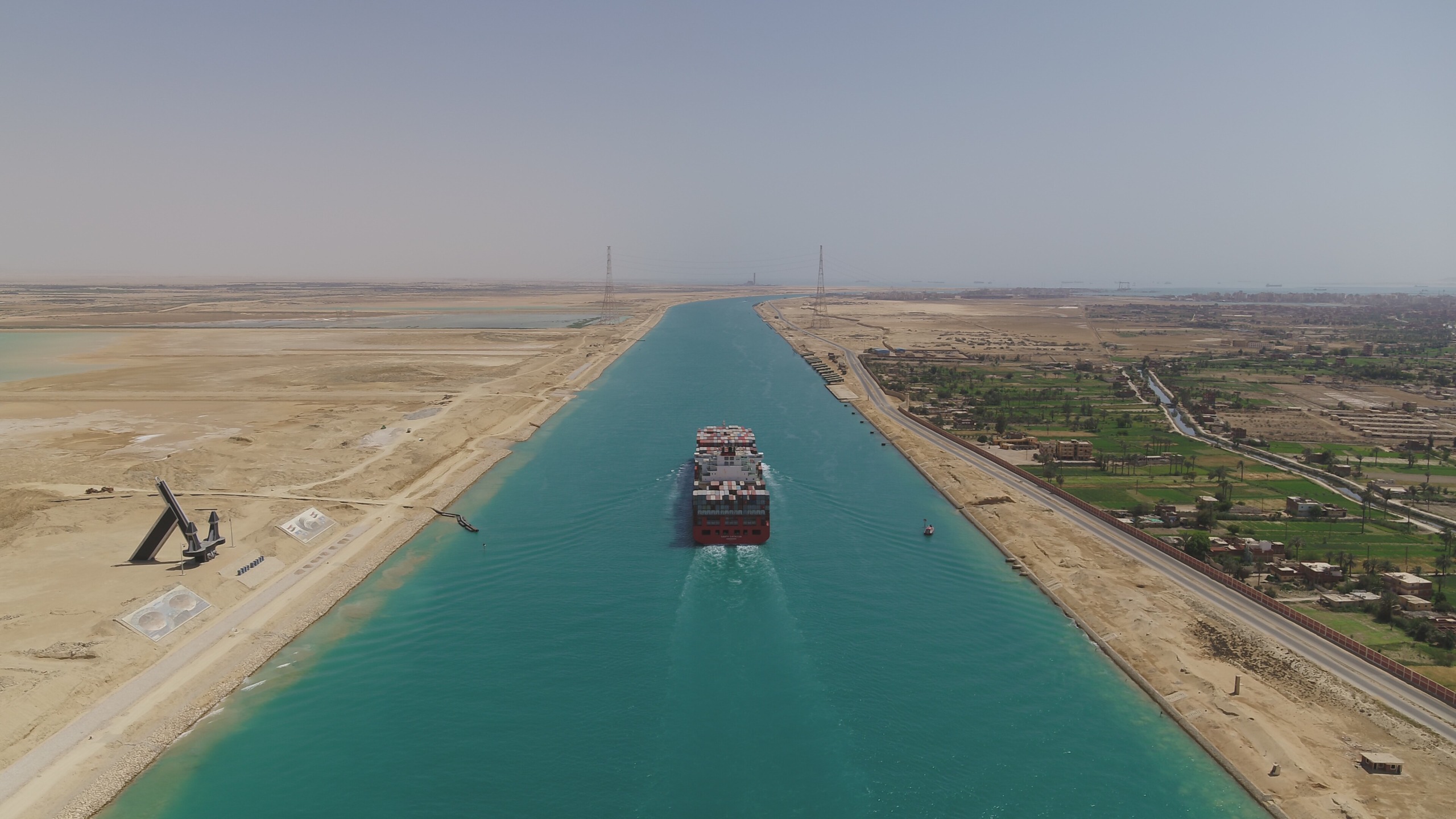
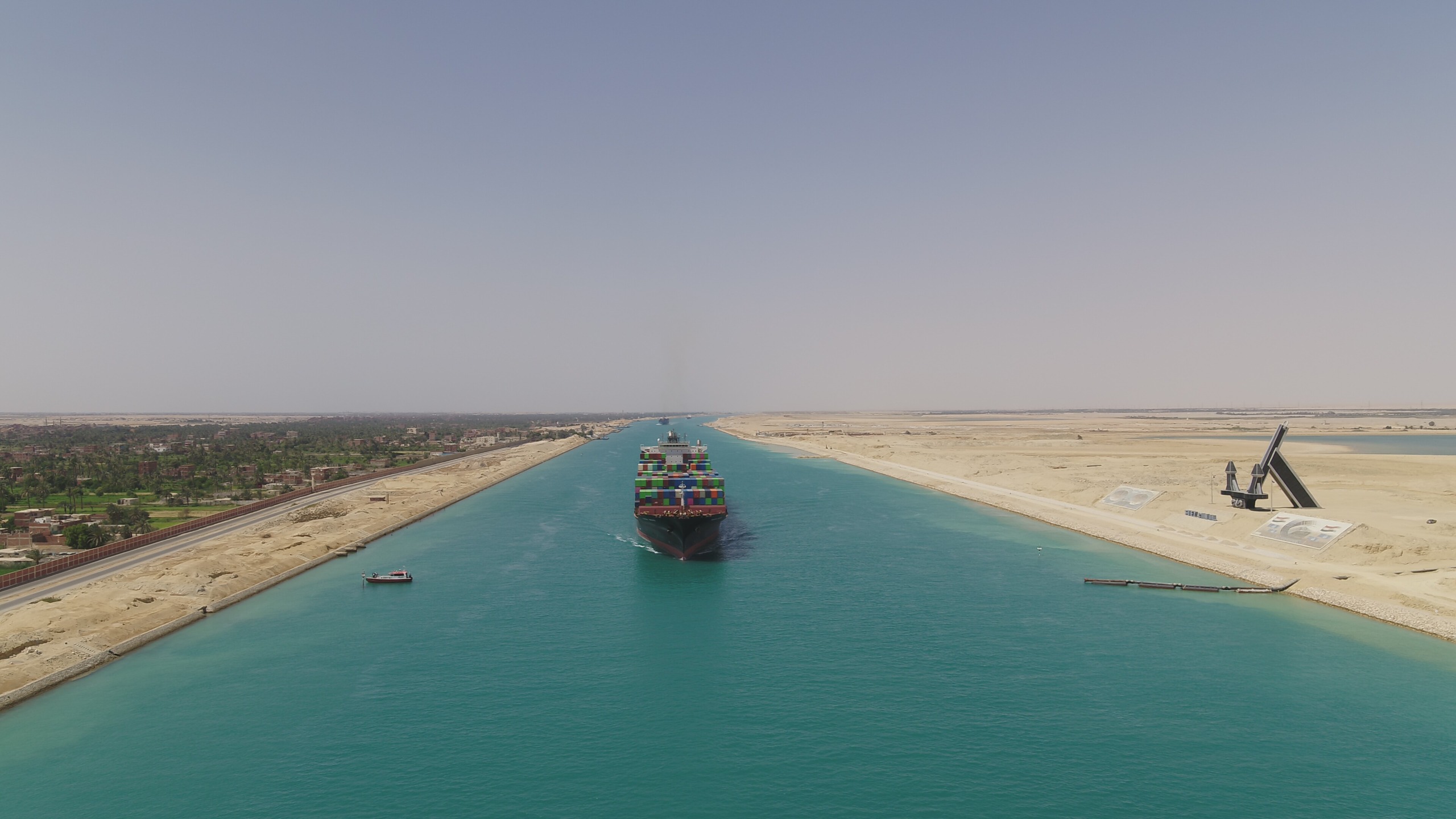
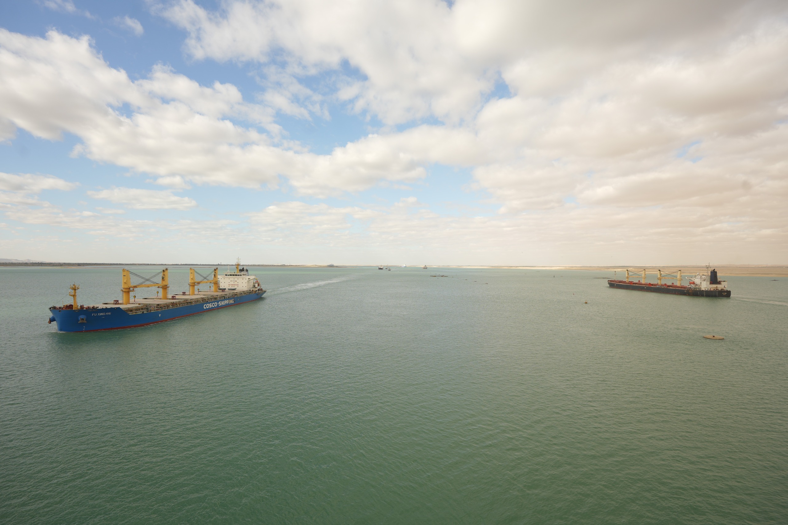
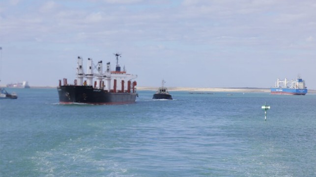
The Canal Duplication Project in the Small Bitter Lakes is Ready for Actual Operation"
Admiral Ossama Rabiee, Chairman and Managing Director of the Suez Canal Authority, has announced the issuance of new navigational charts of the Canal after adding the updates of the southern sector development project, and their approval by the Egyptian Navy's Hydrographic Department (ENHD) and the British Admiralty, which is responsible for issuing electronic charts and navigational data of Egyptian ports and the Suez Canal.
H.E., the Chairman, emphasized that all necessary measures have been completed to ensure that the transiting vessels have acquired the new charts.
Chambers of shipping have been notified, and the Canal’s charts have been amended in the Electronic Chart Display and Information System (ECDIS).
Additionally, navigational updates for paper charts have been issued until the new issue of printed charts for vessels are issued.
H.E. has also stated that the new navigational charts include the 40-meter widening towards the eastern bank within the scope of the Canal’s widening project from km 132 to km 162 (Canal marking) and adding the new doubled part, 10 km in length, from km 122 to km 132 (Canal marking) at the Small Bitter Lakes area, with the navigational aids located on them which ensures navigation safety in the Canal.
Adm. Rabiee has confirmed the technical validity of both parts of the Southern Sector Development Project, and the readiness of the Canal duplication project in the Small Bitter Lakes area for actual operations after the completion of all technical and navigational procedures including the installation of navigational aids, and the completion of training works for the Authority’s pilots on safe transiting through the southern sector at the Suez Canal Maritime Training and Simulation Academy.
The Chairman of Suez Canal Authority has highlighted that the southern sector development project is considered a quantum leap that will contribute to enhancing the competitiveness of the Canal and attracting new classes of ships and marine units that have not transited through the Canal before.
That is in addition to transiting safely and increasing the rates of navigational safety for unconventional transit operations.
Adm. Rabiee has also stressed the navigational and economic importance of the southern sector development project and its role in enhancing the Canal's leadership and raising its global classification with its multiple navigational advantages and most notably increasing the margin of navigational safety and reducing the impact of the pressure of the two banks of the Canal on vessels of a large draft after expanding the Canal 40 meters eastward, and increasing its depth from 66 feet to 72 feet within the Canal's expansion project.
Moreover, the Canal’s doubling project increases the accommodation capacity of the Canal by 6 to 8 vessels on a daily basis and adding 10 kilometers to the length of the New Suez Canal; reaching 82 km instead of 72 km.
Vessels tested the new two-way navigation channels in Little Bitter Lake (Suez Canal Authority)
From Hydro by Sang Yeup Jin, Seungho Lee, Gong-gu Back, Eunmi Chang
Object detection and image classification
To support the prevention of casualties from rip currents, the Korea Hydrographic and Oceanographic Agency (KHOA) applied object detection and image classification technologies to real-time rip current monitoring systems. Such technologies have recently attracted attention in the fields of AI and computer vision. They make it possible to identify rip currents in real-time images and to transmit information about their occurrence to monitoring personnel, thereby enabling immediate response.
Rip currents, regarded as one of the main causes of accidents at swimming beaches during the summer season, are strong and narrow currents of seawater that flow from the coast to the open sea and mainly occur on beaches with a broad, gentle slope. Rip currents occur briefly then disappear, often in good weather conditions, making it difficult to observe them directly at the coast and to identify their characteristics. To address this issue, the KHOA started to apply AI and computer vision technologies such as object detection and image classification in high-risk rip current areas (see Figure 1) where real-time rip current monitoring systems are operational. Transmitting information about the occurrence of rip currents to personnel enables a rapid response before an incidence can occur.
Development of automatic rip current detection technology
The KHOA developed the automatic rip current detection technology at Haeundae Beach; an area with frequent rip currents and many cases of casualties with distinct occurrence patterns that is covered by a real-time rip current monitoring system. This technology applied Ultraltytics’ YOLOv8 (You Only Look Once, version 8) object detection model based on CCTV images of a real-time rip current surveillance system. Unlike existing object detection models that search for regions of interest in an image multiple times using a sliding window or examine multiple candidate regions using a region proposal method, YOLOv8 detects objects by looking at the entire image at once, which significantly improves the detection speed compared to existing models and makes it applicable to real-time object detection.
Figure 1: Rip current monitoring sites
The operating principle of YOLOv8 is as follows (see Figure 2):Image segmentation (grid division): The input image is divided into N×N grids, where each grid cell judges the possibility of an object existing in the image. Bounding box prediction: Each grid cell predicts multiple bounding boxes and the confidence score of each box. Class probability prediction: The probability that each bounding box belongs to a specific object class is predicted. Non-maximum suppression (NMS): The final detection result is derived by keeping the box with the highest confidence among the overlapping boxes and removing the rest.
For the YOLOv8 model to detect rip currents, the researchers needed to train it with images of rip currents and information about them. Three years’ worth of data was used to build training data using images from four CCTVs located at Haeundae Beach to verify the algorithm. Two classes could be identified in the CCTV images: RipCurrent and RipDoubt. RipCurrent refers to a case where a rip current clearly occurs and the flow out of water is visible. RipDoubt, however, refers to a case where the shape of the rip current is unclear. A breaking wave shape, such as a break in the advancing wave crest or two or more wave crests crossing, also shows that a rip current has occurred. In addition, a non-rip current image was added as a background to prevent the false detection of rip currents in situations where no rip currents arise.
Figure 2: The example of YOLOv8. Learning, verification and testing images
The final dataset consisted of 58,000 images. These were divided, using a specific ratio, into learning, verification and testing images. The YOLOv8 model was developed using the learning and verification data for training and evaluated using the test data. The performance was evaluated by calculating precision (the ratio of correctly predicted objects, indicating the probability that the object predicted as A is A), recall (how many of the objects that should be correct were correct and how many of the images with multiple objects called A were verified as A), and mAP (mean average precision; a value that calculates the average precision in various categories and is an indicator of the accuracy of model prediction in multiple classes (RipCurrent, RipDoubt)).
The performance index for the CCTV images showed that the precision was 0.903 (90.3%), the recall 0.917 (91.7%), and the mAP 0.950 (95.0%), all showing excellent verification performances of over 90% (Figure 3).
A rip current automatic detection process was built using the developed model and performed for each frame of the real-time CCTV images. If a rip current detection lasted for less than eight seconds it was considered ‘not detected’; if it lasted eight to 11 seconds it was considered a ‘preliminary detection’, and if it lasted for more than 11 seconds it was considered an ‘actual detection’. The rip current occurrence time is shown on the screen and flashes to alert monitoring personnel if it exceeds a limit.
Figure 3: Examples of prediction of a rip current using CCTV with YOLOv8 at Haeundae in Busan.
Conclusion
Rip currents, which are difficult to predict, are threatening natural phenomena that occur on beaches and can cause fatal accidents. Technology that quickly detects and accurately classifies these rip currents is essential for maritime safety. By combining the automatic rip current detection technology developed through this study with real-time images from a real-time rip current monitoring system, a system that can respond more precisely and quickly to rip current occurrences has been established. This technology could be applied to more beaches and marine environments in the future to accumulate data and improve the performance of the constructed model. This would reduce the loss of life caused by rip currents and create a safer ocean.
While for some, such renaming might seem less important than the big problems the country faces, there is a formal process in the United States for renaming places, and that process is taken seriously. Usually, so people don’t get confused, official, agreed-upon names are used by the government.
In the U.S., place names are standardized by the U.S. Board on Geographic Names, which is part of the U.S. Geological Survey, the agency in charge of making maps.
In his executive order, Trump asks the Board on Geographic Names “to honor the contributions of visionary and patriotic Americans” and change its policies and procedures to reflect that.
Usually, renaming a place starts locally.
The people in the state or county propose a name change and gather support.
The process in each state is different.
Lake Bde Maka Ska, formerly Lake Calhoun, is the largest lake in Minneapolis.
Minnesota recently changed the name of a large lake in Minneapolis to Bde Maka Ska, which the Minneapolis Park Board described as “a Dakota name for the lake that has been passed down in oral history for many years.”
The board voted to change the name and took its request to the county commissioners.
When the county agreed, the request was then sent to the Minnesota Department of Natural Resources, which made it official for Minnesota.
Then, the state of Minnesota sent the request to the Board on Geographic Names, which made it official for the entire U.S.
Members of the Ohio congressional delegation – President William McKinley was from Ohio – objected over many years to requests to rename the mountain, and the board did not act on those requests. The president appoints the secretary of the Interior Department.
The secretary works with the heads of related agencies to appoint the Board on Geographic Names. Current committee policy states, “Input from State geographic names authorities, land management agencies, local governments, and Tribal Governments are actively pursued.”
“The name Denali has been official for use by the State of Alaska since 1975, but even more importantly, the mountain has been known as Denali for generations. With our own sense of reverence for this place, we are officially renaming the mountain Denali in recognition of the traditions of Alaska Natives and the strong support of the people of Alaska.”
If someone objects to a name change, they could ask the courts to rule on whether the name change was made legally.
Until the publication of Guillaume Delisle's famous map Carte de la Louisiane of 1718, this English sea chart was the best printed map available of the Gulf Coast and the mouth of the Mississippi.
The British book, map, and chart-making and publishing firm of Mount & Page may have issued the map separately as early as 1700 since that date appears to the east of the compass rose in the center of the Gulf.
Coastal mapping scholar Jack Jackson speculated that the English probably had access to a captured copy of Spanish pilots Juan Enriquez Barroto's or Juan Bisente del Campo's maps of the Gulf Coast since they reflect Bisente's coastal details and Barroto's toponyms.
Jackson also believed that the inset map at upper left may be based upon information from Captain William Bond's 1699 reconnaissance voyage of the mouth of the Mississippi on behalf of Dr. Daniel Coxe's Anglo-Dutch Carolana Company.
At that time Bond's ship ascended the river to a point just below New Orleans before Bienville convinced him that the French already controlled the river.
Unfortunately, Bond's presumed charts are missing. Mount & Page's chart and its Gulf coast interpretation was also influential for other English chartmakers.
The English Pilot (1775)
Depot de la Marine Nautical Chart or Map of Bay of Campeche, Mexico (1826)
Blachford Blueback nautical chart map : West Indies, Florida, Caribbean and Gulf of Mexico (1838)
On the coast, the first 12 miles from shore are considered part of that country, but outside of that is international waters. The Board on Geographic Names could change the name to Gulf of America on official U.S. maps, but there is no international board in charge of place names.
Each country decides what to call places.
And there is no official way for the U.S. to make other countries change the name.
Gulf of Mexico on NOAA raster charts
It’s possible that the U.S. could formally ask other countries to change the name, or even impose sanctions against countries that don’t comply. If the names were officially changed in the U.S., the government would use the new names in official documents, signage and maps.
As for all the people and companies in the world that make maps, they usually use the official names. But there is nothing that would force them to, if they believed that a certain name is more widely recognized.
On Jan. 24, 2025, the U.S. Department of the Interior issued a statement on the name changes: “In accordance with President Donald J. Trump’s recent executive order, the Department of the Interior is proud to announce the implementation of name restorations that honor the legacy of American greatness, with efforts already underway. "As directed by the President, the Gulf of Mexico will now officially be known as the Gulf of America and North America’s highest peak will once again bear the name Mount McKinley….The U.S. Board on Geographic Names, under the purview of the Department of the Interior, is working expeditiously to update the official federal nomenclature in the Geographic Names Information System to reflect these changes, effective immediately for federal use.”


.jpg)

(1).jpg)
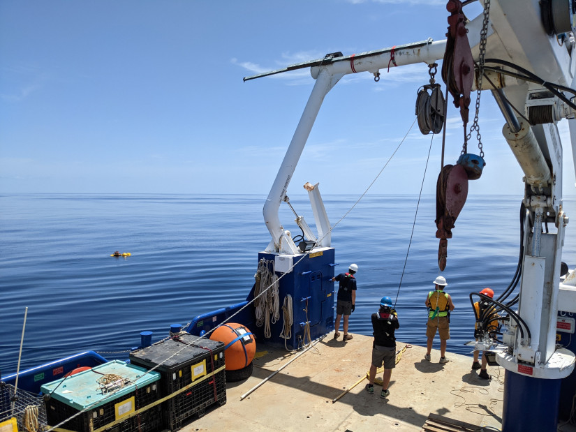 Scripps Oceanography team recovering an acoustic recording package in the Gulf of Mexico.


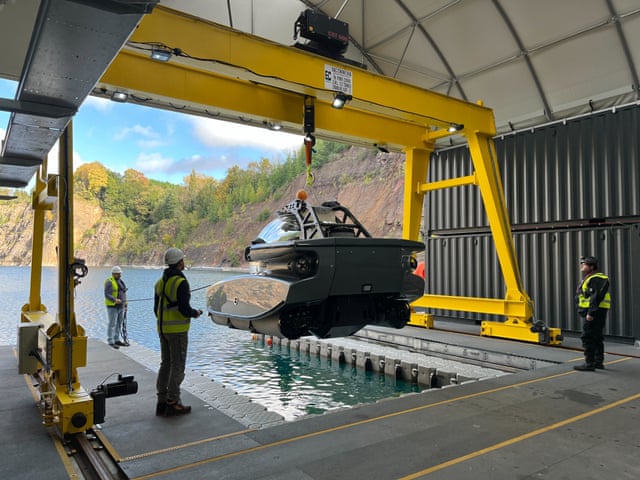
 ‘The perfect location to build and test underwater accommodation’: Deep’s site at a quarry lake in Gloucestershire.


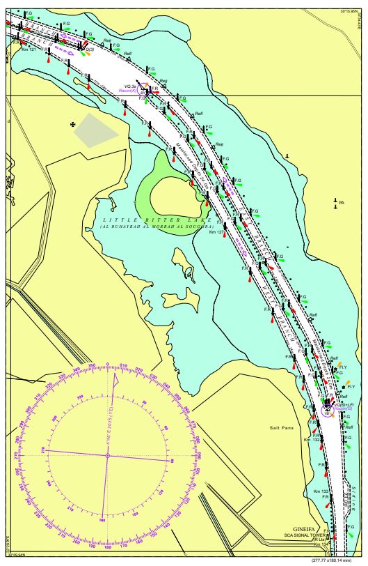

 Vessels tested the new two-way navigation channels in Little Bitter Lake (Suez Canal Authority)

 Figure 2: The example of YOLOv8.
 Figure 3: Examples of prediction of a rip current using CCTV with YOLOv8 at Haeundae in Busan.
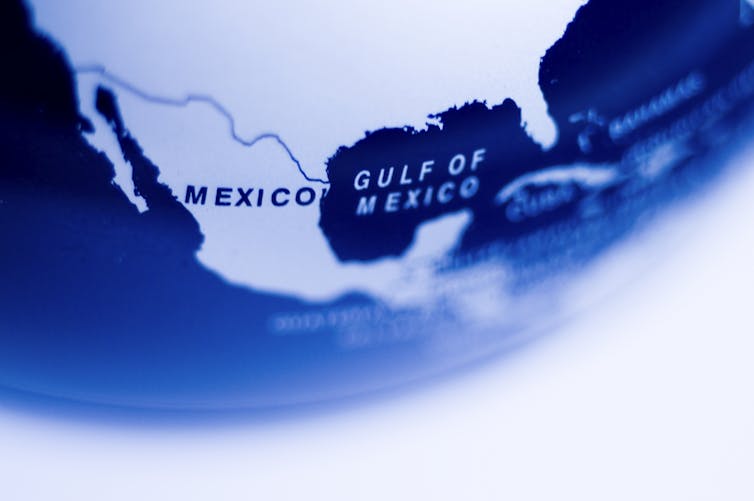


_-_The_fourth_book._Describing_The_West-India_navigation,_from_Hudson's_Bay_to_the_River_Amazones._Particularly_delineating_The_Sea_Coasts,_Capes,_Headlands,_(14780240045).jpg)