Saturday, December 18, 2010

Deep sea exploration with the joint Indonesia-USA Ocean Expedition


NOAA and Google entered into a Cooperative Research and Development Agreement (CRADA) to increase access and reach of NOAA data through the expertise and innovative tools at Google.
This map and its products are a result of collaboration between NOAA and Google and establish a foundation for improving data and product integration and access.

From GoogleLatLon

Come on a tour to never-before explored Indonesian waters.
The
INDEX-SATAL 2010 Expedition is the first-ever joint ocean research voyage by the Republic of Indonesian and the United States.
To experience it yourself, watch the Google Earth YouTube video tour above or explore the area more interactively with the Google Earth plug-in on our
Ocean Showcase.

Much of the Coral Triangle remains unexplored, and this partnership aims to help reverse the decline of coral reefs in the area and to protect natural resources.
The expedition began in the SATAL region around two island chains stretching north of Sulawesi.
It was undertaken by scientists from the USA National Oceanic and Atmospheric Administration, Indonesia’s Ministry of Marine Affairs and Fisheries, and the Indonesian Agency for the Assessment and Application of Technology.

Telepresence” was used to send data in real time to scientists who stood watch at Exploration Command Centers in Jakarta and Seattle.
This same technology brought the excitement of the expedition to visitors at the Exploratorium in San Francisco as well.

Little Hercules, a remotely operated exploration vehicle, descended 6000 feet under the sea to capture images and videos of exciting sights like hydrothermal vents and creatures like the deep sea octopus seen below:

Mapping and discovery data from expeditions like this will help all organizations involved better understand ocean resources and how to protect them.
More information about the still mysterious ocean will ultimately further economic and environmental initiatives such as the management of sustainable fisheries, the conservation of the marine environment a
nd the preservation of fragile corals.

Dive deeper at
Oceanexplorer.noaa.gov, or download this KML for viewing in Google Earth.

Links :

Friday, December 17, 2010

Ocean science giant Alvin set for upgrade


This video walks the viewer through a deep sea dive with Dr. Anna Louise Reysenbach aboard the submarine Alvin

From BBCnews

Few research tools in the history of science can match the achievements of
Alvin, the US manned deep-submersible.

It was this 46-year-old vessel which discovered the hot volcanic vents on the ocean floor that transformed ideas about where and how life could exist.
The sub is also famed for finding an H-bomb lost at sea and for making one of the first surveys of the
Titanic.
But this veteran of the abyss has been withdrawn from service this week as it gets ready for a major re-fit.

Alvin is to undergo a two-phase, $40m (£26m) upgrade that will allow it eventually to stay down longer and to go deeper - much deeper than its current 4,500m (14,800ft) limit.

"Going to 4,500m means we can dive in about 68% of the ocean," explained
Susan Humphris from the Woods Hole Oceanographic Institution (WHOI).
"When we go to 6,500m, we will have access to 98% of the ocean. That will make a huge difference; there is so much more to see down there," she told BBC News.

Dr Humphris has been speaking here in San Francisco at the American Geophysical Union (
AGU) Fall Meeting, the world's largest annual gathering of Earth and planetary scientists.

Alvin made its first dive in 1965. (see history of Alvin)
Since then it has carried some 1,400 people on more than 4,500 dives.
The vessel undergoes a big service every few years, but the
latest will be its most significant to date.

The key
upgrade in the National Science Foundation-funded work will be the integration of a new $10m titanium personnel sphere - the "cockpit" in which the pilot and two research passengers sit.
Forged from giant ingots weighing 15.5 tonnes, this protective ball is 16.2cm (6.4in) larger in diameter than Alvin's current sphere.
Its walls are thicker, too, to cope with the greater pressures at 6,500m.

15.4 tonnes of titanium were required to make the new sphere to carry the crew
The new sphere will have five viewports instead of the existing three.
These windows will provide larger and overlapping views, which will give researchers a much better idea of what is happening outside the sub.

The
WHOI has brought a mock-up of the new sphere to the meeting to show the community what the finished cockpit will be like.

The upgrade will start in January.
When it returns to the water in 2012, Alvin will be a lot more comfortable


Other improvements in the first phase will include a new floatation foam, a new command-and-control system, better lighting and cameras, increased data-logging capabilities, and better interfaces with science instruments.

Not all its components will be changed in the first-phase re-fit, however, and it is only when all the sub's critical elements have been upgraded, including installing lithium-ion batteries for enhanced power, that Alvin will be permitted to go to 6,500m.
That could be in 2015.

"People don't realise that in many ways it's a lot more difficult taking people to the bottom of the ocean than out into space," explained Dr Humphris.
"When you go into space, you're going from one atmosphere of pressure to zero; when going to the bottom of the ocean, you're going from one atmosphere to 650 atmospheres. Alvin is our space shuttle, if you like."

The vessel is a research workhorse.
Its
final dive before the refit occurred on Tuesday when it went down into the Gulf of Mexico to inspect corals, to see how they might have been affected by the recent Deepwater Horizon oil well blowout.

Its greatest contribution to science, however, is unquestionably its discovery in 1977 of a system of
hydrothermal vents off the Galapagos Islands.

Dr Humphris says she has lost count of the number of times she has dived in the famous sub
Before its crew saw the vents' extraordinary array of animals thriving in the mineral-rich, hot waters gushing from cracks in volcanic rock, everyone assumed all the deepest places in the oceans would be like deserts - there would be no life.

Today, we know different, and at this year's AGU meeting, UK scientists have been presenting their discovery of vents at 5,000m, the deepest yet observed.

This system was found in waters at a location known as the Mid-Cayman Rise just south of Cuba. It was explored by robotic vehicles; the Rise is beyond the current capabilities of the manned Alvin.
But one of the discoverers,
Dr Bramley Murton from the National Oceanography Centre (NOC), knows Alvin from a dive he made in the vehicle 10 years ago, and said it would be "phenomenal" to take the upgraded sub to see the new the Mid-Cayman Rise system "face to face".

"These places are extraordinary," he told BBC News.
"You see sights you can barely imagine - rocks covered in bacteria that fluoresce purple, green and blue, and very strange animals. It's a different world down there."

Dr Humphris said Alvin scientists often get asked - as astronauts do - to defend the value of sending people to risky places when robots could do much of this work.

"My answer to that is simple," she said.
"Watch a video of the Grand Canyon and then go there yourself; then you'll realise why we go to the bottom of the ocean with human-operated vehicles. It is this question of having an eye and brain actually looking in 3D at something. I think your whole perspective changes."

"There's a big difference between looking at something on a flat-screen TV and then going down and being there, and being able to see things within their environmental context."

Peter Girguis has no doubts about the need for a human-operated vehicle.
The Harvard University researcher is chair of the deep-submergence science committee.

He told reporters here: "Eighty percent of our biosphere - that is 80% of the portion of our planet that is habitable by life - is deep ocean, deeper than 1,000m.

"Everything that we typically think of, the continents and all that, is a minority.
And Alvin has been enabling us to study about two-thirds of that for many years now.
The Alvin upgrade promises to enable us to have a better capacity to go to deeper depths to study processes that we know are all interconnected.

"Our climate, the health of our ecosystems, the sustainability of our fisheries - all depend on processes that take place in the deep ocean."

Links :
  • OurAmazingPlanet : Upgraded sub could reach 98 percent of ocean deep
  • UNOLS : Alvin upgrade project imaging system

Thursday, December 16, 2010

Free diver first to break 100m unassisted


On December 12, 2010, at 11:43am local time in the Bahamas,
New Zealander William Trubridge dove 100 meters into Dean's Blue Hole on Long Island
with a single breath of air and only his hands and feet to propel him down and up (no fins).

From TheGuardian / NZHerald

New Zealander William Trubridge this week became the first person to dive unassisted (without weights, fins or other aids) to a depth of 100m (328ft) on just one breath of air (held for 4 minutes, 10 seconds) only propelled by his arms and legs, diving down Dean's Blue Hole on Long Island in the Bahamas.

The famous French diver
Jacques Mayol reached this depth in 1980 but used a weighted sled to descend and an inflated lift bag to return to the surface.

Trubridge broke the record on his second attempt of the day, after a bad start on his first try forced him to resurface.

"I entered the water and immediately started shivering. At the end of my breathe-up, as I turned to start the dive, some of the air in my lungs was forced into my mouth, and from there into my stomach. For a split-second I contemplated continuing, but it would have been foolhardy, so I aborted and rolled back onto the surface with a groan of dismay," he said.

Trying again after a short break, his body went into "autopilot" and he has few memories of the dive.

"I remember my depth alarm going off and pulling the tag from the bottom plate, 100 meters below the surface. I remember keeping my eyes half-closed and telling myself to 'relax' and 'flow' as I set off on the long swim back towards the light. And I remember erupting into celebration with my team the moment the judges displayed their white cards"

Freedriving is a dangerous sport and places intense pressure on the body.

"At 100 metres the pressure exerted by overhead water crushes [diver's] lungs to the size of small grapefruit, and the blood vessels inside them swell with blood in order to stop the lungs from imploding. The heart slows to 25 beats per minute, and [diver's] have to fight the narcotic effects of pressurised carbon dioxide and nitrogen - the so-called 'rapture of the deep' that tempts him towards a fateful sleep," said Joy Cottle from
AIDA NZ, the body representing New Zealand freedivers.

Trubridge had already broken the record the day before, but was disqualified by the judges for breaching the rules.

"Yesterday I had already touched the mark and come back cleanly, but a technicality (not taking my noseclip off during the surface protocol at the end of the dive) meant that the dive was disqualified," he said.

It was Trubridge's 13th world-record.
He set his first record of 80 metres four years ago and since then has singlehandedly raised the world-record from 80 to 100 metres.

He dedicated today's dive to New Zealand's
Hector's Dolphin, which is currently in danger of becoming extinct.

Trubridge, 30, grew up in Havelock North, but sailed the Atlantic, Caribbean and Pacific Ocean with his parents.
By age eight he was already diving to a depth of 15 metres.
Trubridge rediscovered free-diving when he was 22 and has spent hours a day underwater since then.

Here is a brief guide to "freediving":

▶ The pressure exerted by water at depths approaching 100m is so great that freedivers' lungs can be crushed to the size of a small grapefruit.

▶ Some freedivers use a special technique known as glosso- pharyngeal breathing to pack their lungs with more air as they plunge into the sea. Also known as "frog breathing", it involves using the vocal cords to force extra air into the lungs.

▶ Freediving dates back to at least 5400BC. Archaeological records from the period show Scandinavian hunters used a freediving technique to look for shellfish.

▶ While Trubridge was the first to dive to 100m without assistance, others have dived deeper with mechanical aids;
Herbert Nitsch holds the record at 214m, which he achieved with the help of a weighted sled.

▶ The most unlikely freediving folk hero is
Stathis Chatzi, who is feted for diving to a depth of 88m in 1913 to rescue a ship's anchor – despite suffering from emphysema.

Links :
  • StuffNZ : Free-diver uses yoga to break world record
  • YouTube : William Trubridge announcing "Project Hector" the 100 meter freediving world record attempt (training for Project Hector)
  • YouTube : previous records 95m / 88m
  • VerticalBlue

Wednesday, December 15, 2010

The oceans' SOS : conversation between Sylvia Earle and Jean-Michel Cousteau


Bob Evans of the Academy of Underwater Arts & Sciences brought together
ocean advocates Sylvia Earle and Jean-Michel Cousteau
to talk about the state of the ocean and what we can do to make a difference.
"The divers voice is an important voice " This conversation took place while the two were attending the Blue Ocean Film Festival in Monterrey, California August 2010.

From LosAngelesTimes

The planet's great communal resource provides protein sources and oxygen and is used for transportation, recreation and inspiration.
It's time to put it at the center of the climate change discussion.

The ocean is our global heat reservoir and one of two major carbon dioxide sinks.
If you agree that humans are trapping heat and carbon dioxide in the planet's atmosphere — and 53 years of rigorous observations at Scripps and other research institutions show that we are — then the ocean must be at the very center of the climate discussion. But it rarely is.

Consider Cancun: The negotiation text presented at the outset of the climate conference contained exactly one passing reference to the oceans, submerged in a Mariana Trench of footnotes.

Our stubborn addiction to burning coal, oil and natural gas is changing not only the composition of the atmosphere but the composition of the ocean as well.
The carbon dioxide those fuels pour into the air inexorably dissolves into the oceans, causing a process known as ocean acidification.
The oceans have absorbed 30% of the carbon dioxide that humans have ever produced, and they continue to absorb more each year.

This force-feeding has changed ocean chemistry.
As carbon dioxide is added to the ocean, it increases the amounts of dissolved hydrogen-carbonate ions and hydrogen ions (and hence acidity) but decreases the amount of carbonate ions.
By the end of the century, acidity will probably double from today's levels, unless we stop pouring carbon dioxide into the atmosphere.

The increasingly scarce carbonate ions are the very ones marine invertebrates combine with calcium ions to make their shells.
Ocean acidification has been likened to an accelerated case of osteoporosis that afflicts creatures such as massive coral reefs and pteropods — tiny snails that are a key food of commercially important fish.
There is also evidence that increasing acidity disrupts the juvenile development of a variety of marine organisms, including clownfish and krill.
Marine organisms are wonderfully suited to adapt to changes in seawater chemistry, but never before in history have they been asked to do this so quickly.

Marine scientists in various countries, including China, Germany and the United States, are engaged in a variety of national research programs focusing on the important biological impacts of ocean acidification.
We need to document which fisheries, coral reefs and marine ecosystems will be affected first, and how long they might take to recover (if at all).
That takes time, but don't be fooled by the pat response: "We need more research first."
We know enough to act now.

Links :

Tuesday, December 14, 2010

Tip of the day : Marine GeoGarage units

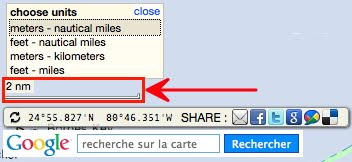
The Marine GeoGarage user has the choice to select his favorite system of units using 2 tools located at the bottom right corner of the main screen:

for the scale bar
clicking to change the scale bar units and switch between :
meters - nautical miles switch (scale : 750 m then next lower scale : 2 nm)
feet - nautical miles
switch (scale : 5000 feet then next lower scale : 2 nm)
meters - kilometers switch (scale : 750 m then next lower scale : 2 km)
feet - miles switch (scale : 5000 feet then next lower scale : 2 miles)

Note : this setup doesn't affect the display of the global distance for a route
-always displayed in meters if D is less of 1852 meters and in nautical miles (nm) if D is greater than 1852 m-

for the Latitude / Longitude display of the cursor position (WGS84)
clicking to select the format on the dedicated icon and switch between :
Degrees & Decimal Minutes : DD°DD.DDD' (default setting for marine locations)
Degrees, Minutes, Seconds : DD°MM'SS.SS''
Decimal degrees : DD.DDDDDDD° (submeter precision, around 0.3 meter at higher Google Maps scale)

Monsoon: the Indian Ocean and the future of American power

Robert D. Kaplan, Monsoon: The Indian Ocean and the Future of American Power, New York:
Random House, 2010, ISBN: 978-1-4000-6746-6, 367 pp. $28.00

From UNC

Global geopolitical analysis had a rocky 20th century.
In the first decade of that century, the British geographer
Halford Mackinder and the American naval strategist Alfred Thayer Mahan wrote brilliant and prescient essays about the structure of world politics and the fundamental factors, most notably geography, that shaped international relations.
Mahan's reputation suffered, however, from the revelation that
Kaiser Wilhelm's Germany imbibed his writings during its quest to wrestle command of the seas from Great Britain; thereby, it was claimed, fueling a naval arms race that led to the cataclysm of the First World War.
Mackinder's reputation and geopolitical conceptions likewise suffered from their subsequent association in the 1920s and 1930s with the German school of
Geopolitik which, it was claimed, provided the intellectual justification for Nazi expansion, thereby producing the even greater cataclysm of the Second World War.

World War II and the early Cold War period revived interest in geopolitics, but for many observers, strategists, and statesmen, the advent of nuclear weapons and intercontinental delivery systems rendered geopolitics irrelevant.
When events demonstrated that nuclear weapons did not mean the end of war or the struggle for power and hegemony, geopolitical analysis returned and scholars and strategists dared to "think the unthinkable," namely that a nuclear war could be fought and won.

Geopolitics suffered again in the 1960s and early 1970s, when Defense Secretary
Robert McNamara and his successors surrendered U.S. nuclear superiority in deference to McNamara's theory of "mutually assured destruction" (MAD), the Vietnam debacle seemingly undermined the utility and morality of "power politics" on the international stage, and the pursuit of an imaginary detente with the Soviet Union fostered the impression that we no longer had an enemy to fear.

It took the loss of U.S. strategic superiority, a Soviet geopolitical offensive in the Third World, and the humiliating defeats suffered by the U.S. under the Carter administration (an administration that openly eschewed geopolitics in favor of "human rights") to bring about a resurgence in geopolitics in the late 1970s and 1980s.

The end of the Cold War, the collapse of the Soviet Empire, the pacification of Europe, and the globalization of technology and information once again called into question the relevance of geopolitics.
History, it was said, had ended. Geo-economics had replaced geopolitics.
As the 21st century approached, the writings of Mackinder, Mahan,
Nicholas Spykman and lesser geo-politicians could safely be ignored.

Then, on a bright September morning in 2001, history reared its ugly head.
The United States was suddenly at war with an Islamic international terrorist organization headquartered in Southwest Asia, but with tentacles throughout the Islamic world and in many non-Islamic countries as well.
Furthermore, three longtime U.S. adversaries with ties to international terrorism, situated at both ends of the middle-belt of Asia--Iran, Iraq, and North Korea-- were actively seeking nuclear weapons.
Meanwhile, China and India were expanding economically and militarily, entering the ranks of rising global powers.

Geopolitics, then, is still relevant in the 21st century, but the focus of geopolitical analysis has shifted from Europe to Asia.
In his new book,
Monsoon: The Indian Ocean and the Future of American Power, Robert D. Kaplan recognizes this shift and narrows the focus even more by identifying the Indian Ocean region as the geopolitical "pivot" of the 21st century.

The Indian Ocean region, Kaplan notes, is host to the "principal oil shipping lanes" and the "main choke points of world commerce," "accounts for one half of all the world's container traffic" and "70 percent of the petroleum products for the entire world."
Through the single
Strait of Malacca flows half of the world's oil and a significant portion of the world's trade.
The region is also home, he notes, to "the entire arc of Islam, from the eastern fringe of the Sahara Desert to the Indonesian archipelago."
Furthermore, China and India, the two most populous countries in the world and the world's most important rising powers, inhabit the region.

Kaplan notes that the littoral of the Indian Ocean is divided geographically by the southern Arabian peninsula, the
Strait of Hormuz (the entrance to and exit from the Persian Gulf), southern Afghanistan, and the Arabian Sea in the west; the subcontinent of southern India and the island of Sri Lanka in the center; and the Bay of Bengal, the west coasts of Burma and Thailand, and the Strait of Malacca in the east.
The strategically vital Strait of Malacca leads to the South China Sea and southern China and, ultimately, to the Pacific Ocean.

Since ancient times, Kaplan explains, the Indian Ocean hosted a "web of trade routes" thanks to the monsoon winds (hence the title of the book).
In the days of sailing ships, "[f]rom the Persian Gulf to Sumatra in the Indonesian archipelago," he writes, "it was a relatively quick seventy-day journey--twice the speed of sail travel in the Mediterranean, owing . . . to the monsoon."
Arab, Chinese, Malaysian, and African seafarers developed "commercial and cultural inter-linkages" across the region.

During the age of European exploration--what Mackinder called the "Columbian epoch"--the region, or at least parts of the region, fell under the sway of Portuguese, Dutch, and later British imperial power.
Kaplan also writes about the land-based
Mughal Empire, which ruled India and adjacent territories in Central Asia from the 16th to the early 18th centuries, but his analysis highlights the enduring role of sea power for both economic and political advantage in the region.

It is here--with his discussion of sea power, China's maritime strategy, and the geopolitics of the region--that Kaplan, relying in part on the important works of
Toshi Yoshihara and James Holmes of the U.S. Naval War College, sheds the most light on the importance of the Indian Ocean region to U.S. security.

Echoing the great Dutch-American geopolitical theorist, Nicholas Spykman, Kaplan calls this region the "maritime rimland of Eurasia." (Spykman, in The Geography of the Peace, famously stated that whoever controls the Eurasian rimland would control the destinies of the world).
Within the Eurasian maritime rimland, "Indonesia--in particular, the island of Sumatra--and peninsular Malaysia on the opposite side of the Strait of Malacca," Kaplan writes, "form the heart of maritime Asia."
The Strait of Malacca, he explains, is "the most vital choke point of world commerce."
It is there where "the shipping lanes of the Red Sea and the Sea of Japan converge," where "the spheres of naval influence of India and China meet," and where "the Indian Ocean joins the western Pacific."

The Indian Ocean region, as Kaplan notes, has been dominated by American sea power since the end of the Second World War.
In the 21st century, that important geopolitical circumstance is changing. China and India are reading Mahan and learning the strategic value of sea power.
Shanghai's ports handle more cargo than any other port in the world.
In five years, China will be the world's largest shipbuilder.
"America's unipolar moment in the world's oceans," warns Kaplan, "is starting to fade."

China's quest for naval power stems, in part, from its insatiable demand for energy.
Energy fuels its remarkable economic growth, and the source of that energy is Middle Eastern oil and natural gas which must transit the Indian Ocean and the Strait of Malacca to get to China's ports.
The "vital sea lines of communication around the southern Eurasian rimland," Kaplan explains, "must be protected."

China's ability to focus on sea power is due to the geopolitical fact that it is "more secure on land than it has been throughout history."
The end of the Cold War and the collapse of the Soviet Empire ended the most recent significant land threat to China's security.
It is an axiom of geopolitics that a power secure from serious challenges on land, can afford to take to the sea.

The Indian Ocean region is more hospitable to China's sea power than its Pacific coast.
Kaplan points out, as Spykman noted more than 60 years ago, that the geography of the western Pacific Ocean frustrates Chinese ambitions in that direction.
Several island chains, anchored by Taiwan, can effectively interfere with China's access to the Pacific.
China's ultimate goal, according to Kaplan, is to construct and develop a two-ocean navy.
"A one-ocean navy in the western Pacific," he writes, "makes China a regional power; a two-ocean navy in both the western Pacific and the Indian Ocean makes China a great power, able to project force around the whole navigable Eurasian rimland."

China does not need to replace the United States as the predominant global sea power to negatively affect U.S. security interests.
Instead, China need only develop the capability to deny U.S. access to key areas along the southern and eastern Eurasian rimland to effectively end U.S. naval predominance in this important region.
In the prophetic words of Nicholas Spykman, "Who controls the rimland rules Eurasia; who rules Eurasia controls the destinies of the world."

Links :
  • USNL : China's navy, a turn to Corbett
  • YouTube : The Indian Ocean and the Future of American Power with Robert Kaplan

Monday, December 13, 2010

iPhone/iPad & GPS

During the last Paris Boat Show in Paris, we got many questions relative to the iPhone and iPad GPS : main is does iPad have a real GPS ?

Indeed, it seems that Apple's first vague announcement wording and
technical spec on its site have left people guessing about whether the iPad has a true GPS chip, and if so, on what models.

To sum up :

  • Location data - The iPad only wifi gets location data ONLY from wifi routers (and external BT receivers if used). iPad with 3G will get location from GPS satellites, cell towers (assisted = A in A-GPS) and wifi.
  1. The wifi only iPad does not have any GPS hardware in it. This is the reason GPS does not work on the wifi only iPad. Hence the technical reason.
  2. The 3G iPad has GPS hardware built in. You do not need 3G service or contract to use the iPad GPS. GPS uses satellites to detect and track location, not 3G services. The A-GPS works to provide a faster initial location than using GPS alone. But the GPS works fine without A-GPS.
  • Map data - In order to use the location data in a GeoGarage mobile app map, the map data must be first loaded in the cache memory to be used later with no internet/data connection. This is good for wifi only iPads with an external BT receiver and iPads with 3G (which have GPS) but no data connection. So to use a cache of the map data already downloaded for the area you are trying out, this requires that you pan around marine navigation zone on all the different zoom levels before turning off Wi-Fi.
So only the iPad 3G model has a GPS chip : (see iFixIt)
it is an AGPS chip - a true GPS chip that is assisted by cellular and WiFi signals, a Broadcom
BCM4750 Assisted-GPS (A-GPS) chipset which is Broadcom’s first single-chip global positioning system (GPS) solution.
But that doesn't mean it's a low-quality GPS chip that needs help.


A-GPS actually provides superior speed and location (think indoors) capability.
The BCM4750 is tailored for mobile devices which have cellular connectivity for A-GPS to provide faster Time-To-First-Fix (
TTFF) than when operating in standalone mode.
So A-GPS just adds faster time to fix from cold and warm startup.
Instead of waiting for the ephemeris/almanac data to come down over the GPS channel (there's some scheduling that dictates this), you just pull it over the Internet and supplant it.
If available, the cellular network also keeps pretty precise time (another thing which gets synced and takes a while on standalone GPSes), which speeds things up.
Lastly, because you know just about where you are (using Cell-IDs and WiFi triliteration through
Skyhook -see coverage-/Google/Apple's list of MACs and GPS coordinates), you've already got a starting point for the optimization routine that is GPS.
All those things added up and you get a fix in under 10 seconds instead of minutes.

The AGPS chipset has massive parallel hardware correlators provide faster signal searches, accurate real-time navigation, improved tracking sensitivity and very low average power consumption.


Wi-Fi, Bluetooth, and GPS are all provided by Broadcom
and located beneath EMI shields on the front side of the board :
iPad 3G and iPhone 4 use the Broadcom BCM4750 receiver GPS

About Broadcom BCM4750IUB8 single-chip GPS receiver (sources iFixIt : 1 / 2 )"High-sensitivity, -157dBm assisted acquisition sensitivity (with coarse time assistance) and -162dBm tracking sensitivity, enabling indoor and deep urban operation"
It’s the low power consumption and the excellent tracking sensitivity of -162 dBm which no doubt convinced Apple to adopt the BCM4750 over the
Infineon Hammerhead II used in the iPhone 3G and 3GS.
The chip consumes less than 15 mW while navigating with one second map updates which is ahead of other published competitive power consumption figures.

There is a preponderance of anecdotal evidence of this chips improved performance over the Hammerhead II. The published sensivity of the Hammerhead II is -160 dBm which doesn’t seem a lot but remember it is a logarithmic scale.
However, it’s important not to put too much weight on the random, unscientific testing available as they are generally under uncontrolled conditions and do not identify what mobile network assistance is provided.
The published steady state position accuracy of the BCM4750 is 2m.
The autonomous (no cellular network assistance) TTFF is market leading being as fast as 0.5s and providing a quick navigation start.
The excellent tracking sensitivity allows the BCM4750 equipped iPad to detect very weak signals including those partially blocked or reflected by buildings or other structures. (
GPSTekReviews)

So Apple iPad purchasers can be confident that they have on-board an excellent GPS receiver to empower all the ever popular location based services and applications loaded on to their device.

 
Apple has integrated the UMTS, GSM, GPS, Wi-Fi, and Bluetooth antennas
into the stainless steel inner frame.

How to determine the accuracy and quality of the GPS signal ?

The GPS signals come down from the visible satellites and the receiver makes its mathematical determination about where is the location (see '
How the GPS works')
To determine the accuracy, the best way to do it is to log NMEA data for several hours with a position each second and then look at the scatter plot with dedicated software (SA Watch or GPSInfo).
The problem with the iPhone/iPad is that there is no way to do that currently, not even to log just the position every second because the programing library doesn't give the access to this data.
The
iOS location API only provides "high level location data" : position (Lat/Lon/Alt/Pitch), fix quality, heading and speed but the number of satellites used, signal strength, accuracy data (HDOP or GDOP) are not available.
By the way, accuracy is also influenced by the number of GPS fixes per second delivered by the sensor : the iPhone 3G‘s update rate is typically around 1.5Hz but can reach values up to 2Hz (comparing to basic 1 Hz marine GPS).

iPhone 3GS/4 needs no 3G service to obtain a GPS position fix.
But it also appears that the various bug fix updates to the firmware are having a significant impact, both good and bad, on GPS accuracy.
Users have experimented some problems with GPS reception on iOS 3 and iOS4 as well (see
Apple support discussions / Apple discussions), with lots of drop outs, making navigation on iPhone 3GS impossible.
In July, Apple silently booted Skyhook and Google from providing GPS data on iOS3.2 and later, creating their own GPS service instead.


How to add an external kit to plug another GPS ?

It's not possible to connect standard Bluetooth-enabled GPS to an iPhone.
Although iPhone has Bluetooth, the firmware denies access to Bluetooth GPS devices that are not specifically designed to work with iPhone.

With jailbroken devices, some applications allow users to add a Bluetooth GPS receiver on iPod Touch, iPhone and iPad. See :
Note : we do not support jailbroken installations and cannot give any guaranties on proper operation regarding all these devices listed for informational purposes only.

Is it possible to connect an external GPS ?

For the moment Apple has not open up their Bluetooth profile to allow to receive NMEA data from a Bluetooth GPS. (
Tekzilla video)
So the other option is to send out raw NMEA-0183 data over TCP/IP via a Wireless Serial Server (
a specific article will be written on the subject next) :
Note : in case of NMEA 2000 output, it's possible to convert the N2k data to NMEA0183 before broascasting over WiFi via some converter :

Using your favorite
Marine GeoGarage iPhone/iPad application, you can preload a geographical area’s worth of nautical maps while you have a WiFi or 3G connection by scrolling around the map to cover your region of interest.
Then, when WiFi is out of range, and 3G is turned off to avoid roaming fees, Marine GeoGarage app shows it's an useful tool for using nautical charts directly with the embedded ihone/iPad GPS.
But don't forget to consider that our mobile application is not to be used as a primary mean for navigation.
Links :

Whales swallow half a million calories in single mouthful


Faint disturbances in the heart of Antarctic waters gives way to
breathtaking images of whales hunting krill
in this fantastic video from BBC natural history masterpiece, Planet Earth.

From LiveScience

The filter-feeding strategy of blue whales, the largest animals on Earth, may explain their enormous size, according to a study that determined a single mouthful of food can contain 457,000 calories, or 240 times as much energy as they burn when grabbing that mouthful.

Blue and some other whale species eat by taking enormous mouthfuls of water and filtering out their meals, often tiny crustaceans called krill, using plates of baleen made of keratin, a protein found in hair, fingernails and feathers.
A team of researchers led by Jeremy Goldbogen, who is now at the Scripps Institution of Oceanography, calculated the efficiency of eating this way.

Their math supports the long-standing assumption that baleen whales are much more efficient feeders than their smaller relatives, the toothed whales, which hunt down individual prey.
The finding is detailed today (Dec. 9) in the Journal of Experimental Biology.

Although the finding isn't a surprise, the baleen whales' efficiency is unprecedented in the animal kingdom, said study researcher Robert Shadwick, who studies animal biomechanics at the University of British Columbia.

"When they take a gulp of water, they are filling their mouths with the amount of water equal to their own body mass, so there is nothing that comes close to doing that," Shadwick told LiveScience.

These whales may eat an enormous quantity of food in a single gulp, but the effort is taxing.
As the animals dive, they lunge into a school of krill and their mouths open to 80 degrees and inflate like a parachute as water gushes in.
This creates a drag, slowing the whale. Whales can make up to six lunges in a dive, according to the researchers.

To figure out how much energy the whales use when they dive, researchers recorded 200 dives between 2002 and 2007.
Then a doctoral student, Goldbogen used recordings of the sounds whales made as they dived through the water to calculate their speed.
He recruited a parachute aerodynamics expert to help work out the forces acting on the whales as they lunged.
Ultimately, they calculated that the whales spent as much as 8,071 kilojoules (1,900 Calories) on a single lunge.

The researchers then measured the jaw bones of whales in museums to estimate the volume of the whales' mouths.
They combined this with krill densities to determine how much energy the animals captured in one mouthful. The answer: up to 1,912,680 kilojoules (about 457,000 Calories).

"They are doing something that is energetically very expensive, but they are getting an enormous payoff," Shadwick said.

Links :
  • BBCNews : Blue whale's gigantic mouthful measured

Sunday, December 12, 2010

The Sharm shark mystery: why are the attacks happening?

Frightening: One of the sharks killed by officials who believed it was responsible for the attacks. But after this shark was killed, the attacks started again (Reuters)

From TheTelegraph

As arguably the world's foremost chronicler of
shark attacks, George Burgess knows better than anyone what the sea's most ferocious predator is capable of.

His position as curator of the
International Shark Attack File, a database started by the US Navy in the 1950s, has forced him to confront the results in mortuaries around the globe.
It is always a harrowing experience, one that demonstrates the fragility of the human body when faced with some of the most powerful jaws in the animal kingdom, as some of the more chilling entries in the shark attack file would attest.

Take the case of Shirley Anne Durdin whose head was decapitated and body torn in two after a White Shark attacked her as she snorkelled for scallops of the South Australian coast in 1985.
Then there was Theo Klein, disembowelled by another White that proceeded to tear chunks of flesh from his dead body in front of hundreds of horrified onlookers in 1971 after he was caught in its jaws off the breakers in Buffalo Bay, South Africa (see
Jawshark.com)

Perhaps because the file, which contains over 4,000 investigations of shark attacks dating back as far as the 16th century, is largely secret, Mr Burgess is reluctant to discuss recent individual cases.

But when it becomes to the business of killing, it is clear that some sharks go about their task with all the finesse of a medieval executioner faced with a treasonous Plantagenet courtier.
"If something is big enough to get its mouth around your head, the neck is very easily severed," he said. "It can be done in several bites or maybe in just one. A large, fully-grown white shark could cut a human in half."

As a scientist, who was drawn into his profession by reading the books of the oceanographer Jacques Cousteau as a child, Mr Burgess has little appetite for the gore of shark attacks that exercises so morbid a fascination on the rest of us.

Yet the bearded conservationist admits that the shark attacks that have taken place off the Egyptian Red Sea resort of
Sharm el-Sheikh in the past fortnight are "right up there" with the most fascinating investigations he has ever mounted.

Over the space of six days, sharks struck at swimmers in relatively shallow waters along a three-mile stretch of beach lined with some of the most exclusive hotels on the Red Sea Riviera. Four people were maimed and a fifth was killed.

Called in to investigate by panicked Egyptian authorities, Mr Burgess was swiftly able to establish that at least two of the attacks were carried out by the same oceanic whitetip shark, an astonishing revelation in a generally extraordinary case.

In recent years, experts have largely debunked the notion that single "rogue" sharks, unlike the predator dreamt up by the author
Peter Benchley in Jaws, ever strike more than one victim. Having discovered that the taste of human flesh is not to their liking, the vast majority of sharks do not make the same mistake again.

Yet photographic evidence clearly showed that a whitetip with a distinctive notch in its tail-fin attacked a Russian man on Nov 30, taking off part of his leg.

Six days later, the same shark returned to a nearby stretch of water by the Hyatt Regency hotel.
As her partner Rudi looked on in horror, Renate Sieffert, a German tourist who had been coming to Sharm el-Sheikh for 10 years, was pulled under the water.
Others swimmers described how she screamed as the churning waves around her turned red while the shark thrashed about, tearing at its victim.
By the time she was pulled ashore, Renate Sieffert was dead.

The whitefin has been all but absolved of involvement in two of the attacks, thought to have been carried out by shortfin makos, but remains a possible suspect in the mauling of Olga Martsinko, a Russian-Ukrainian woman.
So savage was the attack that her left buttock was ripped off, exposing the base of her spinal column.

Only once before has there been unimpeachable evidence of a shark striking more than one human victim.
In 1916, a great white killed four people and injured a fifth along an 80-mile stretch of shoreline off the New Jersey Coast.
The attacks captured the public imagination and became the inspiration for
Jaws.

Although Mr Burgess has investigated that case exhaustively, even recreating the attacks around Matawan Creek, where three of the attacks took place on the same day, he has never been able conclusively to prove why the shark behaved in the way it did.

But the most convincing explanation, he says, is that the great white was in some way injured or malformed, forcing it to attack humans because it was unable easily to hunt its normal prey.
The same may be true of the serial attacker off Sharm el-Sheikh.
"It is something we are looking at here," he said.
"Was this just a shark that made a couple of errors of judgment or decided that humans were ok, or was it an act of desperation by a shark trying to make a living in order to survive?"

Solving the mystery is a little like mounting a murder inquiry.
In the days he has been in Egypt, Mr Burgess has been questioning witnesses, studying photographs, forensic evidence and pathologist reports and scouring the waters near each of the incidents.
The most pertinent questions revolve around what the sharks were doing so close to the shore in the first place.
Both whitetips and makos are pelagic sharks whose natural habitat is far out to sea - and it is here where they are most dangerous.

Whitetips were involved in the deadliest attack on humans ever recorded when they attacked survivors pitched into the water after the USS Indianapolis was struck by a Japanese torpedo in the Pacific in the dying days of the Second World War.
Over 800 sailors survived the initial attack, but over the course of four days in which they trod water clung to flotsam and died of thirst and exposure, at least two dozen, possibly many more, were picked off by whitetips.

But until last week's attacks only two juvenile
whitetips had been seen off the coast of Sharm el-Sheikh all year, according to Elke Bojanowski, an expert on Red Sea sharks.

Preliminary findings suggest that humans, both directly and indirectly, are at the very least accessories to the crime.
Unusually warm water temperatures for the season, perhaps the result of global warming, may have lured the sharks into the northern reaches of the Red Sea, far from their normal habitats.

A ship carrying sheep from Australia is also a prime suspect, after it tossed carcasses and waste into the sea as it voyaged up the Red Sea.
With such a powerful sense of smell, sharks from 100 miles away could have been attracted by the ship - whose owners are facing possible litigation from the Egyptian government - according to Mr Burgess.
When the meat dried up, the sharks would have struggled to find food because of a dearth of tuna, their favoured prey, probably as a result of overfishing.

Despite everything he has seen, and although he nearly became one of his own statistics after narrowly escaping an encounter with a
Lemon Shark by attempting to bop it on the nose, Mr Burgess is a true shark lover.
Sharks may inspire a visceral, even primal fear in humans, particularly after Jaws - a film Mr Burgess says set back the cause of shark conservation by 20 years - but in reality they pose us little danger.

There are an average of five shark-related deaths a year.
By contrast, human beings kill up to 75 million sharks annually, for their fins, a delicacy in China, their meat or simply as bycatch.
With some species seeing their numbers fall by 99 per cent in 50 years, the king of the seas is facing a battle for its survival.
Which is why, he says, it would send the wrong message to hunt and kill the sharks responsible for the Sharm el-Sheikh attacks.
Doing so would not make the beaches safer anyway, something that would be better achieved by increased monitoring of the seas so that beaches can be closed - as happens in America - when sharks are spotted close to shore.
"To catch that animal, you are going to have to find it first," he said.
"That's a lot of expenditure in human time. But in the end what have you got? Sure, you have some retribution for what it did but you have no assurance it was going to do it again and no assurance that its mates won't do it again."

Links :