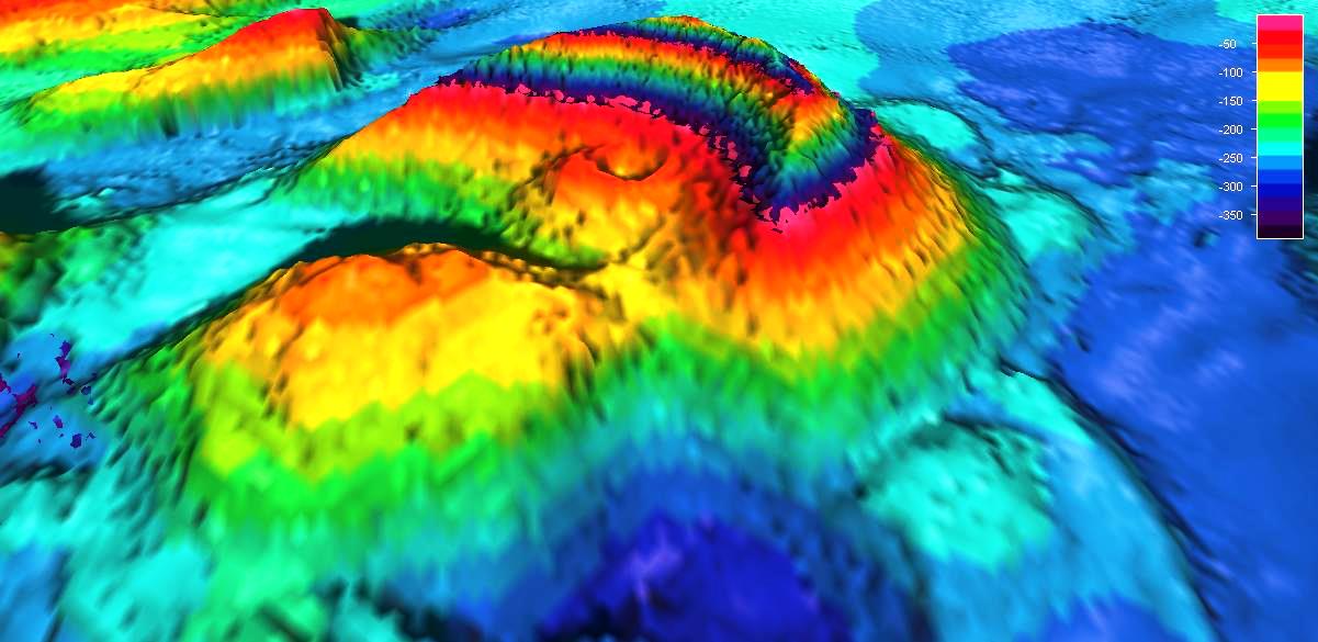
This graphic image provided by Forest Service Geologist Jim Baichtal
shows the newly discovered volcano in Behm Canal near Misty Fiords National Monument.
shows the newly discovered volcano in Behm Canal near Misty Fiords National Monument.
From KTOO
About 10,000 years ago, give or take a couple thousand years, a volcano blew its top in the middle of Behm Canal.
The crater is still there, covered by 150 feet or so of ocean. But when the volcano exploded many thousands of years ago, it was not underwater.
That’s what makes it so interesting.
Well, that and the fact that nobody currently living knew it was even there until just a few weeks ago.
U.S. Forest Service Geologist Jim Baichtal, who is based on Prince of Wales Island, and Anchorage geologist Sue Karl were looking at some hydrographic surveys, something geologists tend to do.
“When we were done, I noticed the area from Thorne Arm to Rudyerd had been surveyed,” Baichtal said. “I zoomed in and there was this large… some kind of volcano, and two other dome-like structures.”

>>> geolocalization with the Marine GeoGarage <<<
Karl added that, “This new NOAA survey allowed us to see things that people had never seen before.”
Baichtal and Karl were in Ketchikan recently.
They came by KRBD, along with UAS Juneau geology professor Cathy Connor, to talk about the underwater volcano.
Baichtal said that after spotting the cone-shaped mass, he used a special computer program to look more closely at the surveys, and they could see the vent still was intact.
They also could tell that it erupted in the air, even though it’s now under quite a bit of water.
But, how could they tell that, just by looking at it?
“Because of the shape of the feature itself, it talks about cinders, or some kind of ash that’s airfall,” he said. “It’s an airfall deposit that forms this … cone.”
Karl said a modern example of a similar eruption is Surtsey, a volcanic island in Iceland, which erupted from the sea floor in the 1960s, building itself up and eventually breaching the surface to form the island.
Karl points out that when the newly discovered volcano erupted, sea levels also were lower than they are now, but even with that, “We still have too much depth. We have to call on glacial loading and rebound.”

Sprinkles of snow dot precipitous cliffs.
Rudyerd Bay area, Southeast Alaska, September 2010.
(Photo by LCDR Mark Wetzler, NOAA Corps.)
(Photo by LCDR Mark Wetzler, NOAA Corps.)
Okay. What does that mean?
“When you get a thousand feet of ice sitting on the ground, it is very heavy,” she explains.
“It actually depresses the earth’s crust. After the glacier melts back, the earth will rebound.”
Like a trampoline, or waterbed, but at a much slower pace.
“So at one time, in Misty Fiords, there was close to 4,000 foot of ice on that site, so the weight of that ice at least pushed down (created) as high as 400 feet of displacement,” Baichtal added.
So, in summary, the volcano erupted within the last 13,000 years, after the ice retreated, as the land was slowly bouncing back, and when sea levels were lower.
They figured out most of this stuff just from examining the surveys.
But Baichtal wanted to see it in person, or as close to in person as possible.
Luckily, he knows some people who can make that happen: Gary Freitag, with the University of Alaska Fairbanks Marine Advisory Program, and Barbara Morgan with Oceans Alaska. They have an ROV, or remote operated vehicle.
It’s a small device that can dive to the bottom of the ocean, get clear video or photographs, and collect samples.
On an unseasonably snowy May morning, they went out with Baichtal on an Allen Marine boat to look for what he calls the “wee beastie on the bottom of the sea.”
Using location data from the survey charts, the skipper was able to “park” the catamaran right on top of the crater, and they quickly sent the ROV into the water.
“From that, we could see the angle of the slopes,” he said.
“We did one deep dive, about 340 feet down. You could kind of tell the way the thing was put together. The lower material was … lava that was quenched in the marine environment, and the upper stuff was the airfall.”
They also grabbed two rock samples, which will be chemically analyzed to determine a more exact age for the eruption.
Baichtal notes that southern Southeast Alaska isn’t well known for its volcanoes, but there are quite a few in this region.
“We know that we have a lot of volcanoes out in the Aleutians, but if you talk about volcanoes in Southeast, everybody imagines Edgecumbe … when in fact, south of Craig and south of Ketchikan here, we actually have a much larger number of vents and a bigger volcanic complex. It’s just less known,” he said.

New Eddystone Rock with shoals exposed August 2010.
(Photo by Alan Wu/Wikimedia Commons)
(Photo by Alan Wu/Wikimedia Commons)
That’s because some are underwater, and those that aren’t are covered by trees.
Karl said as people explore more of the area’s wilderness, they’re discovering more vents.
Volcanoes show up along faults in the earth’s crust, so when the fault moves enough to expose magma, that can lead to a volcanic eruption.
Since faults don’t go away, volcanic eruptions in Southeast Alaska are possible in the future.
“With the evidence that we have and the geologic age of the things that are there, there is no reason why it couldn’t,” he said.
“I wouldn’t be surprised if it did.”
But, Karl said people shouldn’t get anxious about it.
“We have much better technology for detecting the initiation of one of these sorts of things now,” she said. “I don’t think people need to get too worried.”
The newly discovered volcano is very close to New Eddystone Rock, which is what’s left over from another volcano, which may have erupted around the same time frame.
They are both near the entrance to Misty Fiords National Monument.
No comments:
Post a Comment