Saturday, August 1, 2026

Friday, July 31, 2026
New Zealand’s ‘rocket man’ takes on Elon Musk and Jeff Bezos

Peter Beck founded Rocket Lab in 2006 with the goal of launching lightweight rockets more cheaply © Rocket Lab
From FT by Nic Fildes in Auckland
Peter Beck’s Rocket Lab builds out internet satellite business to rival Starlink and Amazon Leo
After successfully launching New Zealand’s first rocket into space, billionaire Sir Peter Beck is setting his sights on taking on Elon Musk and Jeff Bezos in the internet satellite business.
Last month, the Rocket Lab founder signed the biggest cheque of his life, agreeing to pay $8bn for US-listed satellite communications provider Iridium.
The deal adds a valuable network and spectrum — often called the “lifeblood of the mobile industry” — to the New Zealand-founded business, which makes and launches rockets and other space components.
“It’s a big swing for Rocket Lab to go and buy something like that, but at the end of the day it’s a positive cash-generating business that’s well established,” Beck told the FT.
After successfully launching New Zealand’s first rocket into space, billionaire Sir Peter Beck is setting his sights on taking on Elon Musk and Jeff Bezos in the internet satellite business.
Last month, the Rocket Lab founder signed the biggest cheque of his life, agreeing to pay $8bn for US-listed satellite communications provider Iridium.
The deal adds a valuable network and spectrum — often called the “lifeblood of the mobile industry” — to the New Zealand-founded business, which makes and launches rockets and other space components.
“It’s a big swing for Rocket Lab to go and buy something like that, but at the end of the day it’s a positive cash-generating business that’s well established,” Beck told the FT.

A test of Rocket Lab’s Archimedes vacuum engine © Rocket Lab
It made its first successful launch in 2009, and by 2017 its orbital Electron rockets had emerged as a competitor to SpaceX’s Falcon 9 for satellite launches.
“When you compare us to Jeff and Elon, we are definitely the plucky upstart,” said Beck.
“You don’t hear me talking about mining asteroids orbiting Mars,” referring to Musk’s vision for space mining.
The Iridium deal fulfils Beck’s long-held ambition to expand into satellite services.
The Iridium deal fulfils Beck’s long-held ambition to expand into satellite services.
It also puts Rocket Lab into further competition with Musk and Bezos, who have expanded their Starlink and Amazon Leo satellite networks.
SpaceX bought EchoStar’s spectrum for $17bn last year and Amazon acquired Globalstar for $11.6bn in April.
By purchasing Iridium’s network and spectrum over building their own, “we’ve short-cut that by 10 to 20 years”, said Beck.
By purchasing Iridium’s network and spectrum over building their own, “we’ve short-cut that by 10 to 20 years”, said Beck.
He added that Iridium would benefit from Rocket Lab’s launch infrastructure to reduce the cost and risk of launching a new constellation in the future.
“Whoever has the rocket has the keys to space,” he said.
“Whoever has the rocket has the keys to space,” he said.

The acquisition of Iridium gives Rocket Lab a valuable satellite network © Justin Ide/Bloomberg
Beck’s sale of 5mn shares for $465mn has added to the pressure.
The chief executive said Iridium, which unlike Rocket Lab is already profitable, would add a strong customer base and “an incredibly defensible high-value niche” in areas such as maritime communications. Beck said Rocket Lab would look to expand those services.
Luke Pearce, an analyst at CCS Insight, said the acquisition would accelerate competition in the booming sector for low Earth orbit (LEO) satellite services. “This creates another credible LEO competitor alongside players such as SpaceX, Amazon Leo and AST SpaceMobile,” he said.
Rocket Lab has been an extraordinary success story for Beck and for New Zealand.
The chief executive said Iridium, which unlike Rocket Lab is already profitable, would add a strong customer base and “an incredibly defensible high-value niche” in areas such as maritime communications. Beck said Rocket Lab would look to expand those services.
Luke Pearce, an analyst at CCS Insight, said the acquisition would accelerate competition in the booming sector for low Earth orbit (LEO) satellite services. “This creates another credible LEO competitor alongside players such as SpaceX, Amazon Leo and AST SpaceMobile,” he said.
Rocket Lab has been an extraordinary success story for Beck and for New Zealand.
A far-flung sheep farm on the thinly populated east coast of the North Island is now a hotspot for rocket launches.
The country ranks third for the number of rockets launched, behind the US and China, as its remote location has proved ideal for firing projectiles into space without disrupting aviation and maritime traffic.
The country ranks third for the number of rockets launched, behind the US and China, as its remote location has proved ideal for firing projectiles into space without disrupting aviation and maritime traffic.
 Rocket Lab conducts most of its launches from a remote site in New Zealand’s Māhia Peninsula © Rocket Lab
In the three months to March, the company reported revenue of $200mn, up more than 60 per cent from a year earlier, and narrowed its net loss to $45mn from $60mn.
Valued at $40bn, Rocket Lab is by far the largest company to emerge from “the land of the long white cloud”, which has historically produced national champions from its dairy and white-goods sectors. Despite the recent fall, its shares are up nearly 600 per cent since its 2021 Nasdaq offering.
The listing minted more than 100 millionaires in New Zealand. Former employees have gone on to found some of the country’s most promising start-ups including ag-tech company Halter, automotive supply chain group Partly and local rival Dawn Aerospace.
Rocket Lab relocated its headquarters to California in 2013 and has become a key supplier to the US defence department, but it still launches most of its rockets from a remote site in the North Island’s Māhia Peninsula.
Its large manufacturing facility east of Auckland sits at the base of a sedate cul-de-sac where pūkeko swamp hens peck at the lawns. Inside the factory, 1,000 people assemble rockets under giant New Zealand and American flags.
Valued at $40bn, Rocket Lab is by far the largest company to emerge from “the land of the long white cloud”, which has historically produced national champions from its dairy and white-goods sectors. Despite the recent fall, its shares are up nearly 600 per cent since its 2021 Nasdaq offering.
The listing minted more than 100 millionaires in New Zealand. Former employees have gone on to found some of the country’s most promising start-ups including ag-tech company Halter, automotive supply chain group Partly and local rival Dawn Aerospace.
Rocket Lab relocated its headquarters to California in 2013 and has become a key supplier to the US defence department, but it still launches most of its rockets from a remote site in the North Island’s Māhia Peninsula.
Its large manufacturing facility east of Auckland sits at the base of a sedate cul-de-sac where pūkeko swamp hens peck at the lawns. Inside the factory, 1,000 people assemble rockets under giant New Zealand and American flags.
 Rocket Lab relocated its headquarters to California in 2013 and has become a key US defence supplier © Rocket Lab
Beck credits his father for igniting his aerospace passion during his youth in Invercargill, on the tip of New Zealand’s South Island.
The engineer recalled how his father would point at the stars and say: “There could be someone standing there looking back at you.”
“That for me was bigger than anything in my brain,” Beck said, and gave him a “soft spot for the planetary stuff”.
Rocket Lab’s previous acquisitions include companies that supply wheels, cameras, robotics and other essential components used for missions to Mars, Venus and the Moon.
The engineer recalled how his father would point at the stars and say: “There could be someone standing there looking back at you.”
“That for me was bigger than anything in my brain,” Beck said, and gave him a “soft spot for the planetary stuff”.
Rocket Lab’s previous acquisitions include companies that supply wheels, cameras, robotics and other essential components used for missions to Mars, Venus and the Moon.
Iridium represents a new frontier for the company.
“You definitely make your own luck, but it was fortunate that all of those stars aligned,” Beck said of the deal.
“You definitely make your own luck, but it was fortunate that all of those stars aligned,” Beck said of the deal.
Links :
- PR Newswire : Iridium and SKYWAVE™, an ORBCOMM® company, Partner to Advance Global Industrial IoT for Heavy Equipment OEMs
- Mobile world : Iridium brings LEO to Skywave fleet management
- GlobeNewsWire : Rocket Lab to Acquire Iridium in Historic Deal, Creating A Fully Vertically Integrated Space Powerhouse Primed for Growth (YouTube)
Thursday, July 30, 2026

How tanker data revealed a $13 billion question about Venezuelan oil revenues
From The Shipping Brief
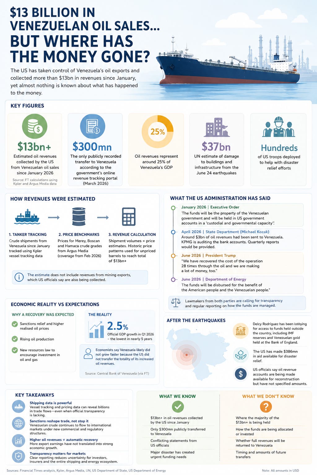
A recent Financial Times analysis estimated that the US administration has collected more than $13 billion in revenues from Venezuelan crude exports since January 2026.
Rather than relying on official financial disclosures, the analysis combined Kpler's tanker-tracking data with Argus Media's crude price assessments to estimate the value of exported cargoes.
Beyond the political implications, the article demonstrates how shipping data is increasingly being used to quantify commodity flows and estimate financial outcomes where official reporting is limited.
Beyond the political implications, the article demonstrates how shipping data is increasingly being used to quantify commodity flows and estimate financial outcomes where official reporting is limited.
The key figures
Several figures stand out from the analysis:
- More than $13 billion in estimated oil revenues generated from Venezuelan crude exports since January 2026.
- Approximately $300 million publicly recorded as transferred back to Venezuela through the government's online tracking portal.
- Oil accounts for around 25% of Venezuela's GDP, making export revenues a major contributor to the country's economy.
- Following the June earthquakes, the United Nations estimates reconstruction costs of approximately $37 billion, increasing the importance of access to these revenues.
Shipping data as a source of financial intelligence
One of the more interesting aspects of the Financial Times investigation is its methodology.
The revenue estimates were derived by combining tanker movements tracked by Kpler with price assessments from Argus Media for Venezuela's principal crude grades, including Merey, Boscan and Hamaca.
This approach illustrates how maritime data has become an increasingly valuable analytical tool.
Vessel movements provide visibility into export volumes, while commodity price assessments allow analysts to estimate the value of those exports with a reasonable degree of confidence.
As a result, shipping data is now used well beyond operational and logistics purposes. Investors, commodity traders, policymakers, sanctions specialists and journalists increasingly rely on vessel-tracking data to monitor trade flows and assess market developments.
As a result, shipping data is now used well beyond operational and logistics purposes. Investors, commodity traders, policymakers, sanctions specialists and journalists increasingly rely on vessel-tracking data to monitor trade flows and assess market developments.
This is Venezuela.
— Fabulero (@todorumba) July 29, 2026
Out in open waters -Bajo Barcelona- where ships anchor before coming in to load crude oil at the Eastern Cryogenic Complex (José)
There are 27 cargo ships visible to the naked eye!
Where is all that oil going? Where is all the money from those sales? pic.twitter.com/kd7aZe1UEI
The transparency gap
The article also highlights differing public statements regarding the management of Venezuelan oil revenues.
The January Executive Order described the United States as acting in a "custodial" capacity for the revenues.
The Department of Energy subsequently stated that the funds would benefit both Americans and Venezuelans.
President Trump later said the United States had recovered the costs of the operation "28 times" and was "making a lot of money" from Venezuelan oil.
At the same time, lawmakers from both Republican and Democratic parties have called for greater public reporting on how these revenues are being managed.
The differing statements, combined with limited public disclosure, have led to increased scrutiny of the administration of these funds.
The Department of Energy subsequently stated that the funds would benefit both Americans and Venezuelans.
President Trump later said the United States had recovered the costs of the operation "28 times" and was "making a lot of money" from Venezuelan oil.
At the same time, lawmakers from both Republican and Democratic parties have called for greater public reporting on how these revenues are being managed.
The differing statements, combined with limited public disclosure, have led to increased scrutiny of the administration of these funds.
Venezuela's economic performance
The article also considers the apparent disconnect between improving conditions in the oil sector and broader economic performance.
Despite:
- higher realised oil prices following sanctions relief;
- increasing oil production; and
- legislation intended to encourage foreign investment,
Economists cited by the Financial Times suggest that one possible explanation is that not all export proceeds have entered the Venezuelan economy.
While this is presented as one potential factor rather than a definitive conclusion, it offers a possible explanation for why stronger oil sector performance has not translated into faster economic growth.
A broader takeaway
The article provides another example of how maritime data is reshaping market transparency.
Where official reporting is incomplete or delayed, vessel-tracking data can provide an independent means of estimating export volumes and, when combined with pricing data, the value of commodity flows.
For those involved in shipping, energy or commodity markets, this reinforces the growing role of maritime intelligence.
Where official reporting is incomplete or delayed, vessel-tracking data can provide an independent means of estimating export volumes and, when combined with pricing data, the value of commodity flows.
For those involved in shipping, energy or commodity markets, this reinforces the growing role of maritime intelligence.
Shipping data is no longer used solely to monitor vessels and cargoes; it has become an important source of insight into trade flows, commodity markets and the economic consequences of geopolitical events.
Links :
Wednesday, July 29, 2026
France had never seen a ‘fire cloud’ until this month’s record-smashing blazes

Photograph: Maximilien Lamy/Getty Images
From Wired by Brian Kahn
Firefighters in France are confronting a phenomenon never seen in the region before: fire clouds.
It’s a sign of the intensity of the blazes burning—and how climate change is upping the odds that they appear.
A wave of fires has swept over France and Spain, sending hundreds of thousands fleeing.
A wave of fires has swept over France and Spain, sending hundreds of thousands fleeing.
Firefighters on the front lines are facing what a spokesperson for the French firefighter association told AFP said was an “operational impossibility”—in other words, a “natural force beyond our control.”
As evidence of how out of control the wildfires in France are, look no further than the skies where the blazes have, in some cases, created their own weather.
As evidence of how out of control the wildfires in France are, look no further than the skies where the blazes have, in some cases, created their own weather.
To form a fire cloud—what meteorologists call a pyrocumulonimbus or the even more metal-sounding cumulonimbus flammagenitus—you first need heat, which fires have in spades.

image : Romain Perrocheau / AFP / Getty Images
But just as important are dry conditions near the ground and cool, relatively moist conditions aloft in the atmosphere.
As superheated smoke rises miles above the flames and into the cool atmosphere, water vapor condenses around the particles of ash to form water droplets.
(Yes water vapor and water droplets are two different things.) As the air keeps rising, those water droplets eventually become ice crystals.
At this point, the smoke and water droplets have created a cloud, but unfortunately one that’s unlikely to provide much relief in the form of rain.
At this point, the smoke and water droplets have created a cloud, but unfortunately one that’s unlikely to provide much relief in the form of rain.
Instead, these towering fire clouds can unleash lightning strikes that start more fires and generate powerful downdrafts that reach the ground to fan flames further.
At their worst, pyrocumulonimbus clouds can even spawn tornadoes.

Pyrocumulonimbus clouds have been documented in the US, Canada, and Australia, among a handful of other locations.
Pyrocumulonimbus clouds have been documented in the US, Canada, and Australia, among a handful of other locations.

But until now, there were no documented fire clouds in France.
While the country is no stranger to wildfires, the size and ferocity of this summer’s blazes is well outside the normal.
Last week was France’s single most destructive week for wildfires over the past 20 years, according to data from the European Forest Fire Information System.
Last week was France’s single most destructive week for wildfires over the past 20 years, according to data from the European Forest Fire Information System.
It more than doubled the previous record during that period, which coincides with accurate satellite data.
This isn’t an isolated bad week either. More than 220,000 acres have burned across the country so far, six times the annual average.
That’s 61,000 acres higher than the previous yearly record.

photo Stephan Rahmstorf
If that sounds like a familiar trend, well, it unfortunately is.
Burning fossil fuels has heated the planet up, making explosive wildfires more common and destructive around the world.
A 2024 study found the incidence of extreme fires globally more than doubled from 2003 to 2023.
Six of the seven most extreme years have happened since 2016.

photo : Patrice Gaulupeau
After a slight weekend reprieve as temperatures dipped, they’re expected to rocket back up above 104 degrees Fahrenheit (40 degrees Celsius) in France and 108 degrees Fahrenheit in Spain later this week.
That means firefighters will have to contend with more extreme fire weather—including the possibility of clouds created by the blazes themselves.
Links :
Tuesday, July 28, 2026
In a first, scientists witness the seafloor spread in real time, giving them a rare glimpse at a mysterious geologic process
:focal(750x500:751x501)/https://tf-cmsv2-smithsonianmag-media.s3.amazonaws.com/filer_public/e0/13/e013da54-f91c-45d2-9297-8717082a49cc/smithsonian_feature_images_7.png)
From The Smithsonian by Margherita Bassi
Across a matter of days in 2024, the seafloor in part of the Indian Ocean dropped by about 13 feet, and roughly 5.7 billion cubic feet of molten rock rose to the crust’s surface, according to a new study
Researchers observed seafloor movement at the Southeast Indian Ridge, denoted by the yellow line. NOAA
Earth’s outermost layer—the crust—is constantly renewing itself.
It’s broken into giant chunks called tectonic plates that pull apart, push against or slide past one another, creating grand geologic features.
Underwater mountain ranges, or mid-ocean ridges, for instance, generally take shape where two tectonic plates are moving away from each other.
Underwater mountain ranges, or mid-ocean ridges, for instance, generally take shape where two tectonic plates are moving away from each other.
Magma can then bubble up in between, solidifying and turning into new oceanic crust as part of a process called seafloor spreading.
Although the phenomenon has created entire ocean basins, it remains quite mysterious because it happens so deep in the water.
Now, for the first time, scientists have observed this dynamic activity happening in real time.
Now, for the first time, scientists have observed this dynamic activity happening in real time.
They describe their findings—and their stroke of luck—in a study published July 8 in the journal Nature, shedding light on a mechanism that made roughly two-thirds of Earth’s crust.
“We still know remarkably little about the frequency, magnitude and dynamics of the eruptions and tectonic processes that build [mid-ocean ridges],” Isobel Yeo, a geoscientist at the National Oceanography Center, a nonprofit in the United Kingdom, who did not participate in the study, tells Davide Castelvecchi at Nature.
In February 2024, the research team behind the new study traveled by ship to the southern Indian Ocean, where the Southeast Indian Ridge sits on the border between two tectonic plates that travel away from each other by about 2.4 inches per year.
“We still know remarkably little about the frequency, magnitude and dynamics of the eruptions and tectonic processes that build [mid-ocean ridges],” Isobel Yeo, a geoscientist at the National Oceanography Center, a nonprofit in the United Kingdom, who did not participate in the study, tells Davide Castelvecchi at Nature.
In February 2024, the research team behind the new study traveled by ship to the southern Indian Ocean, where the Southeast Indian Ridge sits on the border between two tectonic plates that travel away from each other by about 2.4 inches per year.
There, they deployed a bevy of scientific instruments on the seafloor, including acoustic beacons and underwater microphones to detect sound waves, acoustic sensors that pick up on seafloor movement, and a pressure gauge.
Then, they waited—but not for long.
On April 26, 2024, a series of earthquakes struck, marking the beginning of a seafloor spreading event. “We have been very lucky to have had all these instruments set up when it happened,” study co-author Jean-Yves Royer, a marine geophysicist at the French National Center for Scientific Research, tells the New York Times’ K.R. Callaway.
Then, they waited—but not for long.
On April 26, 2024, a series of earthquakes struck, marking the beginning of a seafloor spreading event. “We have been very lucky to have had all these instruments set up when it happened,” study co-author Jean-Yves Royer, a marine geophysicist at the French National Center for Scientific Research, tells the New York Times’ K.R. Callaway.
“But also, we are lucky because these big piles of lava outpoured one or two kilometers [around a mile] away from our instruments, so we didn’t lose any data.”
Quick fact: When did the Earth’s crust start to shift?
In March, researchers reported the oldest direct evidence of tectonic plate movement.
Quick fact: When did the Earth’s crust start to shift?
In March, researchers reported the oldest direct evidence of tectonic plate movement.
Rock samples from Western Australia hint that the planet’s outermost layer was in motion as early as 3.48 billion years ago, roughly one billion years after Earth formed.
Across six days, the seafloor dropped by about 13 feet, the team found.
Across six days, the seafloor dropped by about 13 feet, the team found.
And overall, the tectonic plates moved apart by at least 6.5 feet.
Both numbers came as a surprise.
“We were expecting to measure a few centimeters of horizontal displacement and maybe a few centimeters of vertical displacement,” Royer tells Scientific American’s Sam Macdonald.
Mapping of the bottom of the ocean before and after the event suggests that around 5.7 billion cubic feet of lava—roughly 65 times the volume of the Great Pyramid of Giza—emerged in about 16 days to form a new seafloor.
Mapping of the bottom of the ocean before and after the event suggests that around 5.7 billion cubic feet of lava—roughly 65 times the volume of the Great Pyramid of Giza—emerged in about 16 days to form a new seafloor.
Computer simulations suggest that the event primarily happened because magma was pushed upward through cracks in the crust, driven by the emptying of an underground reservoir of the molten rock.
What’s more, the detected earthquakes didn’t seem powerful enough to be responsible for the observed horizontal changes, supporting the idea that most tectonic plate movement at mid-ocean ridges does not create seismic activity.
What’s more, the detected earthquakes didn’t seem powerful enough to be responsible for the observed horizontal changes, supporting the idea that most tectonic plate movement at mid-ocean ridges does not create seismic activity.
The work also suggests that at these plate boundaries, quiet stretching continues until stress builds up enough to trigger a sudden seafloor spreading event.
“It’s quite difficult, and perhaps rare, to make these measurements,” Aaron Micallef, a marine geologist at the Monterey Bay Aquarium Research Institute who did not participate in the study, tells the Times. “We know so little about what’s going on in these settings that we’re not even really sure of what measurements we need to carry out, so that’s why it’s very useful to throw all the instruments that you have at the problem, as these researchers have done.”
Links :
“It’s quite difficult, and perhaps rare, to make these measurements,” Aaron Micallef, a marine geologist at the Monterey Bay Aquarium Research Institute who did not participate in the study, tells the Times. “We know so little about what’s going on in these settings that we’re not even really sure of what measurements we need to carry out, so that’s why it’s very useful to throw all the instruments that you have at the problem, as these researchers have done.”
Links :
- East Africa Might Break Off From the Continent Sooner Than Scientists Thought—and a New Ocean May Fill the Gap
- In a First, Scientists Find Animals Thriving Beneath the Ocean Floor in Hidden Habitats Near Deep-Sea Vents
- Remnants of Life Found Half a Mile Below the Seafloor
- This 340-Million-Year-Old Ocean Crust Could Date Back to Pangaea
- Scientists Extract Rocks From Earth’s Mantle
Monday, July 27, 2026
China’s shadowy maritime militia is worryingly active
In December over 1,000 Chinese fishing boats lined up to form an L shape in the seas north of Taiwan. Over the next few months they coalesced again on four more occasions. Our animated maps visualise the unprecedented activity https://t.co/rWSIFrx6LL pic.twitter.com/90Nb3pPOCF
— The Economist (@TheEconomist) July 26, 2026
In December over 1,000 Chinese fishing boats lined up to form an L shape in the seas north of Taiwan. Over the next few months they coalesced again on four more occasions. Our animated maps visualise the unprecedented activity
Source: Starboard Maritime Intelligence
From The Economist by
Big new formations north of Taiwan suggest officials are testing out its capabilities
The bays of the Zhoushan archipelago are crammed with blue-hulled fishing boats, laid up after a busy season scouring the East China Sea for crabs and croaker.
Some of the boats, though, have been doing more than just fishing.
In December over 1,000 vessels from Zhoushan and other parts of China’s eastern seaboard did something unprecedented.
They lined up to form an L shape in the seas north of Taiwan, held the formation for more than 12 hours, then dispersed.
Over the next few months Chinese fishing boats coalesced again in the East China Sea, on four more occasions.
Chinese state-run media claim all this is normal commercial activity.
Something fishier is surely going on.
China is unusual in having three separate maritime forces at its disposal.
The first two are the navy and the coastguard.
But since as far back as the 1950s, China’s leaders have also commandeered part of the country’s fishing fleet as a paramilitary “maritime militia”.
This shadowy force is made up of a mixture of normal fishing boats and larger, steel-hulled ones which appear to be purpose-built for aggressive manoeuvres.
It is notorious for its activities in the South China Sea, where militia boats are often sent to disputed reefs and islets to secure China’s sovereignty claims, sometimes violently.
Fishing boats in the East China Sea had largely stuck to trawling.
That may be changing.
The recent formations there were far larger than anything seen before, even in the South China Sea, so it seems likely they brought together many ordinary fishing boats alongside formal militiamen.
They were packed densely enough that some cargo ships appeared to change course to go around them.
The manoeuvres suggest Chinese officials are testing out their capabilities—and some fear that could give China an edge in a conflict over Taiwan.
 Fishing boats set sail in August 2025 from the bays of the Zhoushan archipelago, south of Shanghai.
Fishing ban lifted in China and 2,500 boats just stormed out of Zhoushan like a seafood army
Image: Getty Images
Image: Getty Images
NEW:
— Megatron (@Megatron_ron) August 7, 2025
🇨🇳 Fishing ban lifted in China and 2,500 boats just stormed out of Zhoushan like a seafood army
The great crab haul begins… pic.twitter.com/Biv27E54Rq
No official numbers are published on the size of China’s maritime militia.
State news outlets sometimes deny that it even exists.
But an article published in 2014 in a Chinese defence journal praised the force as “irreplaceable” thanks to its “wide distribution, disguised identities and familiarity with maritime conditions”.
Unlike its navy, China’s militia gives officials plausible deniability for ambiguous “grey zone” activities: they can claim, for instance, that violent spats with other countries’ ships were caused by “patriotic fishermen” acting independently.
For decades the maritime militia had a reputation as a ragtag bunch, with antiquated weapons and poor discipline.
The average fisherman has only a limited education and greying hair (only 5% are below the age of 30, according to a survey in 2024; fishing is tough and few Chinese youths want to do it).
That means training them to use the latest communications technologies can be a challenge.
Motivation can also be a problem because compensation is reportedly low.
That is partly because the militia is meant to act out of patriotic duty rather than for personal gain, says Collin Koh of Nanyang Technological University in Singapore.
Local governments and military authorities also sometimes squabble over who should foot the bill.
But since Xi Jinping came to power in 2012, China has been trying to build what it calls a “new-style” maritime militia—one that is better equipped, trained and organised.
How much is being spent on this militia is hard to say.
Provinces and cities contribute towards a variety of schemes, and state-owned firms are encouraged to chip in.
Some fishing boats can get daily subsidies of over 24,000 yuan ($3,500) to loiter in disputed areas, more than enough to cover their costs and allowing owners to profit without doing any fishing.
advertisement
Modernisation has gone furthest in the South China Sea, a vast body of water which China claims almost in its entirety (six other countries, including Vietnam and the Philippines, have competing claims over the region, which is rich in fish stocks and energy resources).
Some locals have become full-time militiamen, crewing large steel-hulled vessels equipped with big water cannons.
They swarm around the shoals and reefs that China claims while surveilling and harassing foreign vessels.
Militia activities are inherently hard to track, but appear to have been steadily increasing in the South China Sea.
The Asia Maritime Transparency Initiative, a programme at CSIS, an American think-tank, uses satellite images to check for telltale signs such as vessels loitering without deploying fishing gear, or tying themselves together to form a floating barrier.
Last year it counted an average of 241 Chinese vessels that it believes were militia sailing in disputed areas of the region every day.
That was the highest number since CSIS started monitoring in 2021.
State news outlets sometimes deny that it even exists.
But an article published in 2014 in a Chinese defence journal praised the force as “irreplaceable” thanks to its “wide distribution, disguised identities and familiarity with maritime conditions”.
Unlike its navy, China’s militia gives officials plausible deniability for ambiguous “grey zone” activities: they can claim, for instance, that violent spats with other countries’ ships were caused by “patriotic fishermen” acting independently.
For decades the maritime militia had a reputation as a ragtag bunch, with antiquated weapons and poor discipline.
The average fisherman has only a limited education and greying hair (only 5% are below the age of 30, according to a survey in 2024; fishing is tough and few Chinese youths want to do it).
That means training them to use the latest communications technologies can be a challenge.
Motivation can also be a problem because compensation is reportedly low.
That is partly because the militia is meant to act out of patriotic duty rather than for personal gain, says Collin Koh of Nanyang Technological University in Singapore.
Local governments and military authorities also sometimes squabble over who should foot the bill.
But since Xi Jinping came to power in 2012, China has been trying to build what it calls a “new-style” maritime militia—one that is better equipped, trained and organised.
How much is being spent on this militia is hard to say.
Provinces and cities contribute towards a variety of schemes, and state-owned firms are encouraged to chip in.
Some fishing boats can get daily subsidies of over 24,000 yuan ($3,500) to loiter in disputed areas, more than enough to cover their costs and allowing owners to profit without doing any fishing.
advertisement
Modernisation has gone furthest in the South China Sea, a vast body of water which China claims almost in its entirety (six other countries, including Vietnam and the Philippines, have competing claims over the region, which is rich in fish stocks and energy resources).
Some locals have become full-time militiamen, crewing large steel-hulled vessels equipped with big water cannons.
They swarm around the shoals and reefs that China claims while surveilling and harassing foreign vessels.
Militia activities are inherently hard to track, but appear to have been steadily increasing in the South China Sea.
The Asia Maritime Transparency Initiative, a programme at CSIS, an American think-tank, uses satellite images to check for telltale signs such as vessels loitering without deploying fishing gear, or tying themselves together to form a floating barrier.
Last year it counted an average of 241 Chinese vessels that it believes were militia sailing in disputed areas of the region every day.
That was the highest number since CSIS started monitoring in 2021.
 Militia vessels have long swarmed Whitsun Reef, part of the Spratly Islands in the South China Sea.
 The boats often tie themselves together, as in this image from April.
Image: Satellite image ©2026 Vantor
China has disputes in the East China Sea too, with Japan and South Korea in addition to Taiwan.
But militiamen have historically been much less aggressive in the region, instead focusing on civilian matters like emergency relief after typhoons.
The East China Sea is less than one quarter the size of the South China Sea, and China’s claims there are over specific areas such as the uninhabited Senkaku islands (known as the Diaoyu in Chinese, and which Japan controls) rather than over the entire body of water.
Its coastguard should, therefore, be able to patrol and handle confrontations with other countries’ vessels without relying on civilian boats.
All of this adds to the mystery surrounding the recent formations.
Five took place in less than six months, according to IngeniSPACE, a research company tracking their movements.
But militiamen have historically been much less aggressive in the region, instead focusing on civilian matters like emergency relief after typhoons.
The East China Sea is less than one quarter the size of the South China Sea, and China’s claims there are over specific areas such as the uninhabited Senkaku islands (known as the Diaoyu in Chinese, and which Japan controls) rather than over the entire body of water.
Its coastguard should, therefore, be able to patrol and handle confrontations with other countries’ vessels without relying on civilian boats.
All of this adds to the mystery surrounding the recent formations.
Five took place in less than six months, according to IngeniSPACE, a research company tracking their movements.
Nagasaki Shanghai Zhoushan East China Sea
TAIWAN SOUTH KOREA
JejuJAPANOkinawa (Japan) CHINA
Chinese vessels, last known position
- The first assembled over 1,000 ships into two parallel formations, stretching 450km, around Christmas Day.
- During the next formation, in January, some boats stayed in place for over 30 hours.
Days earlier China had conducted large-scale war games around Taiwan. - In late March a new formation appeared 100km to the east and closer to Jeju, a South Korean island.
- Boats congregated for the latest formation, in April, on the same meridian, shortly before the start of China’s annual summer fishing ban.
Co-ordinating so many ships to stay in place for so long is a technical challenge, but more importantly a political one, says Gregory Poling of CSIS.
Some countries struggle to make their fishermen broadcast their locations consistently (many prefer to keep their choicest fishing grounds a secret).
China has shown “a degree of political control that no other country on earth can claim” over its civilian fleet, notes Mr Poling.
Some countries struggle to make their fishermen broadcast their locations consistently (many prefer to keep their choicest fishing grounds a secret).
China has shown “a degree of political control that no other country on earth can claim” over its civilian fleet, notes Mr Poling.
What could such control be used for?
In a conflict over Taiwan, the militia might help the navy with reconnaissance or logistics.
Militia boats have also been accused of cutting undersea-communications cables.
If China launched an amphibious invasion of Taiwan, a callous commander might use swarms of fishing boats to overwhelm the enemy with potential targets.
A very large number of fishing boats could play a more important role if China tried to impose a full blockade of the island, or a more calibrated “quarantine” (blocking only some goods).
They could help disrupt the flow of shipping to and from its ports.
The fishermen of Zhoushan, at least, have no love lost with Taiwan.
In 1950 Zhoushan was one of the last regions of China held by the Kuomintang after their defeat by the Communist Party.
Thousands of local men were press-ganged to replenish its army, and forced to go to Taiwan.
Some locals are still bitter.
More prosaically, one grizzled captain says a conflict would be a disaster for business.
He would help only if the authorities demanded it.
One younger man, though, is confident that local fishermen would play their part.
“We Chinese are like scattered sand that would unite if the time came,” he said.
“We’d all become militia.”
Militia boats have also been accused of cutting undersea-communications cables.
If China launched an amphibious invasion of Taiwan, a callous commander might use swarms of fishing boats to overwhelm the enemy with potential targets.
A very large number of fishing boats could play a more important role if China tried to impose a full blockade of the island, or a more calibrated “quarantine” (blocking only some goods).
They could help disrupt the flow of shipping to and from its ports.
The fishermen of Zhoushan, at least, have no love lost with Taiwan.
In 1950 Zhoushan was one of the last regions of China held by the Kuomintang after their defeat by the Communist Party.
Thousands of local men were press-ganged to replenish its army, and forced to go to Taiwan.
Some locals are still bitter.
More prosaically, one grizzled captain says a conflict would be a disaster for business.
He would help only if the authorities demanded it.
One younger man, though, is confident that local fishermen would play their part.
“We Chinese are like scattered sand that would unite if the time came,” he said.
“We’d all become militia.”
Sunday, July 26, 2026
Map the travels of Homer's Odysseus

The Odyssey, traditionally attributed to Homer and composed around the 8th–7th century B.C., recounts the ten-year journey of Odysseus (also known as Ulysses), king of Ithaca, as he attempts to return home after the Trojan War.
Although set in the Mediterranean world, this epic blends myths, memories, and geography in a way that defies literal cartography.
Since antiquity, readers have attempted to locate Odysseus’s wanderings—from the land of the Cyclopes to the island of Circe—on a real-world map, but the poem functions less as a travelogue than as a narrative about human resilience, identity, and the testing of heroic virtue.
Efforts to anchor these events in real places reflect a broader desire to reconcile mythical narrative with new historical and geographical research on the ancient Greek world.

Map created by Simeon Netchev
to illustrate the narrative flow of Homer's Odyssey
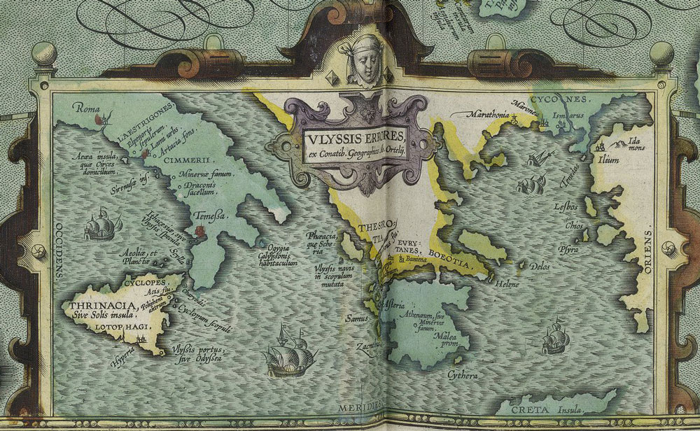
Attempts to map the *Odyssey* gained momentum in the early modern era, notably with Abraham Ortelius’s 1597 map, the first known cartographic representation of Odysseus’s journey.
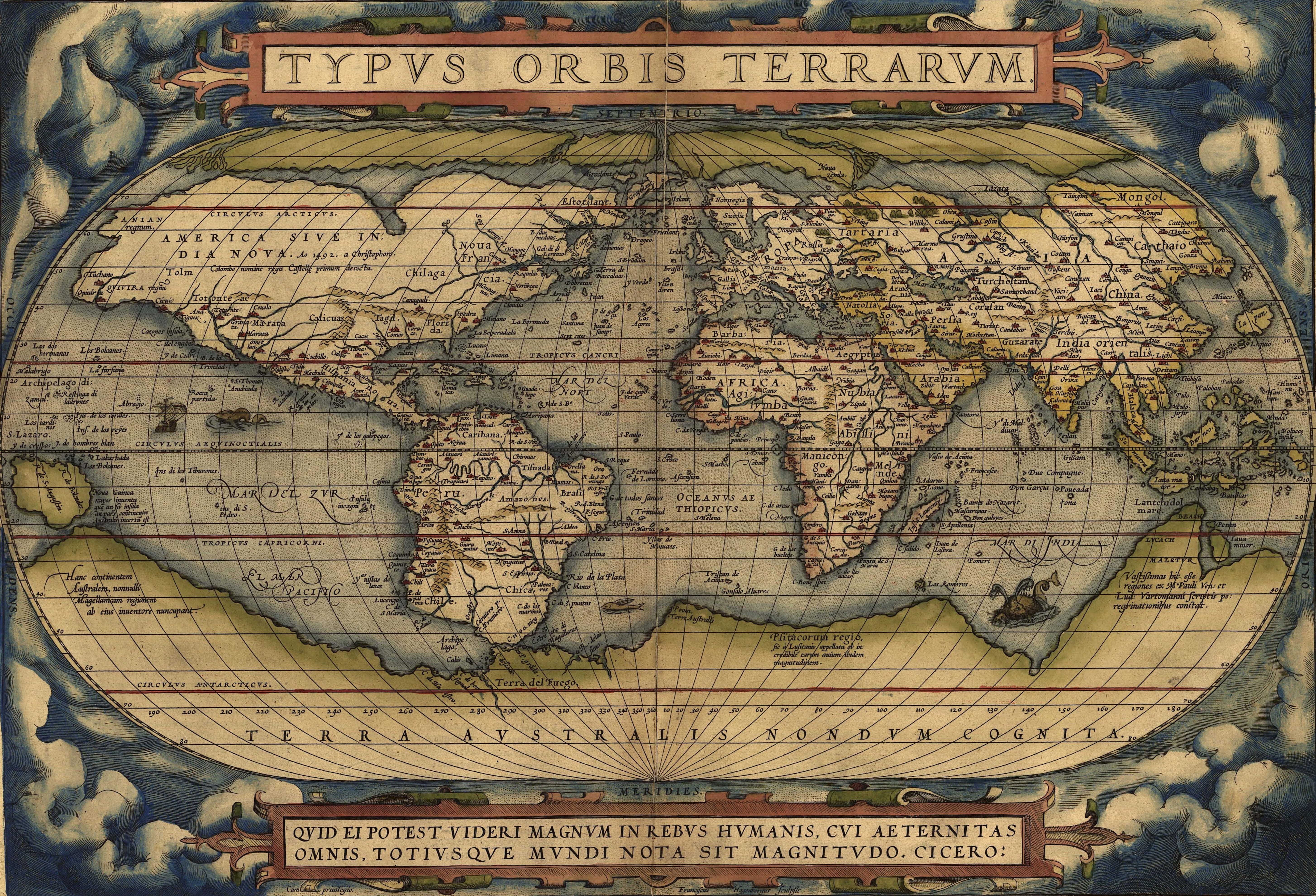
“Ulyssis Errores,” by Abraham Ortelius, in Theatrum Orbis Terrarum, c. 1608.
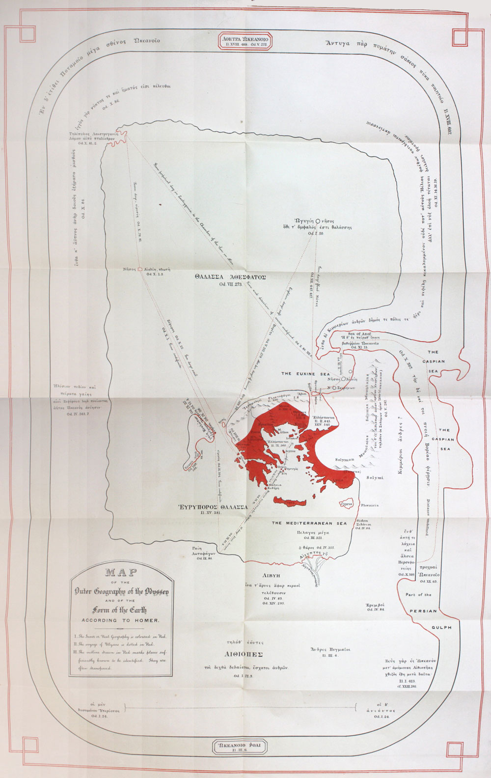
Real geography, both transposed and not, is colored red on Gladstone’s map. “Map of the World According to Homer,” by W.E. Gladstone, in Studies on Homer and Homerica Age, Vol. 3 (1858).
Over the centuries, scholars, statesmen, and philologists—including figures such as British Prime Minister William E. Gladstone—have proposed competing interpretations, but no consensus has emerged, thus revealing the poem’s fundamentally symbolic geography.
Modern studies, such as classicist Peter T. Struck’s analysis (2000) from the University of Pennsylvania, highlight how the epic’s spatial logic serves its narrative themes rather than a strict topography.
This map draws on these ideas, illustrating not a definitive itinerary, but the enduring fascination with situating Homer’s imaginary world within the broader Mediterranean region.

illustrateur ; Théo Schmied (1901-1985), graveur Provenance
BnF, département Réserve des livres rares, VELINS-1248
BnF, département Réserve des livres rares, VELINS-1248
Links :
- Lapham : The geography of the Odyssey
- Cartonumerique : Le voyage d'Ulysse. Comment cartographier un mythe ?
- Peter Struck’s Odyssey
- The Odyssey interactive map / Journey / Odysseus journey / Open Culture
- The Conversation : Can we map The Odyssey? How ancient geographers and modern researchers have traced Odysseus’s travel
- Britannica : Geography of Homer’s Odyssey: Mapping Odysseus’s Epic Voyage
Subscribe to:
Posts (Atom)