This is where the ocean turns dark forever
— Science girl (@sciencegirl) February 24, 2026
pic.twitter.com/TiKNoLC0JU
Saturday, March 14, 2026
Where the ocean turns dark forever
Friday, March 13, 2026
ATSB: Cruise ship's chief mate distracted by ECDIS ahead of grounding
ATSB published a preliminary report on our on-going investigation into the grounding of cruise ship Coral Adventurer, which occurred on the north-east coast of Papua New Guinea in late 2025.
The cruise ship Coral Adventurer ran aground on a reef off Papua New Guinea after the ship's ECDIS declined to load the chief mate's route plan, the first in a series of events that led to the ship overshooting a turn and overcorrecting, according to the Australian Transport Safety Bureau (ATSB).
On the morning of December 27, 2025, Coral Adventurer was under way off the remote northeastern coast of Papua New Guinea and nearing the small port of Dregerhafen.
.png?itok=VzT2Sf6D)
Source: Google Earth, Coral Expeditions, annotated by the ATSB
The waters on the approach are ringed by reefs, with large areas poorly surveyed, and vessels have to execute two tight turns to reach the harbor entrance - first to port, then to starboard.
.png?itok=6PXdNz-Z)
Coral Adventurer's grounding location and planned trackline, red
Aerial view of the entry to Dregerhafen.
Insert below shows the view from the approximate ship’s position 3 minutes before grounding, taken from the height of the bridge in daylight.
Source: Sebastian Bang, annotated by the ATSB.
Insert view, the ATSB.
At the start of the 0400 watch, the cruise ship was approaching Dregerhafen's harbor entrance.
.png?itok=h9yF8pyN)
The chief mate had the conn, and decided to adjust the route in the ECDIS to smooth out the second of the two turns of the transit, thereby creating a new route plan in the digital chart system's storage.
The new Route 2 still adhered closely to the passage plan's track, but with an extra waypoint.
At 0512, as the approach to the port was in progress, the mate selected this modified route and tried to activate it.
At 0512, as the approach to the port was in progress, the mate selected this modified route and tried to activate it.
The ECDIS declined to do so until after it had performed a route safety check in its route editor tool.
The chief mate had to go through the process of this digital check mid-transit.
The chief mate had to go through the process of this digital check mid-transit.
.png?itok=sj0zOGR5)
At 01513, the Coral Adventurer missed its first wheel over point and overshot its turn to port.
This put it on course to enter unsurveyed and potentially hazardous waters to the north of the route.
The chief mate put steering in manual and made a harder turn to get back onto the route.
The vessel returned to the planned track, but slowed down, affected by a strong current at the entrance channel.
.png?itok=N7mEe97J)


The chief mate increased RPM on both thrusters to offset the current, which had reduced speed to less than four knots.
Planned track (blue) and actual track (red) overlaid on vector chart in use on board Coral Adventurer at the time of the grounding.
Source: Australian Hydrographic Office, modified and annotated by the ATSB


Localization with the GeoGarage platform (nautical raster chart with ZOC & ENC)
With the throttes pushed up, the mate put steering back into autopilot at about 0518, in advance of the second turn.
At 0519, the vessel arrived at the second wheel over point, making eight knots.
The vessel overshot the turn again, prompting the mate to switch back to manual once more at 0521.
The ship was off course to the west of the intended trackline, and the mate made a hard turn to starboard to get onto the planned track.
At this point, the chief mate lost situational awareness, they later told investigators.
At this point, the chief mate lost situational awareness, they later told investigators.
.png?itok=prznG2wv)
Source: Coral Adventurer, annotated by the ATSB
In darkness and without navigation aids, they did not have a sense of the surrounding topography.
The mate kept up the high rate of turn to starboard until 0523:30, coming up on a northeasterly heading back towards the trackline.
Misinterpreting the view ahead and believing that the ship was back on track, the mate continued to navigate across the trackline, making more than eight knots.
At 0524, the master arrived on the bridge, and visually spotted shallow water ahead; the ship grounded about 15 seconds after the master's warning.
At 0524, the master arrived on the bridge, and visually spotted shallow water ahead; the ship grounded about 15 seconds after the master's warning.
The Coral Adventurer came from 8.5 knots to a halt by 0525:30.
Dive inspections revealed that the hull was not penetrated, and that the propulsion was intact.
Dive inspections revealed that the hull was not penetrated, and that the propulsion was intact.
.png?itok=24ELrmAY)

Source: Coral Expeditions, annotated by the ATSB
A tug was chartered for a refloat attempt, but this was initially unsuccessful, as the tug's engines overheated during the effort.
A larger tug was dispatched, and the Coral Adventurer was successfully refloated on December 30.
Wednesday's report is a factfinding summary, without causal findings. ATSB's inquiry into the cause of the grounding remains under way.
Wednesday's report is a factfinding summary, without causal findings. ATSB's inquiry into the cause of the grounding remains under way.
Links :
- ABC : ATSB releases preliminary report into Coral Adventurer cruise ship grounding off PNG
- MarineLink : ATSB Releases Preliminary Report on Coral Adventurer Grounding
- Safety4Sea : ATSB issues preliminary report into the grounding of a passenger ship
- SeaTradeCruise : Coral Adventurer under second investigation after grounding
- 7News : Navigation errors led to Coral Adventurer grounding in Papua New Guinea, preliminary report reveals
- The Australian : Preliminary ATSB report into Australian expedition cruise ship Coral Adventure released, navigational error blamed for days-long stranding
- BBC : Cruise ship hits reef on first trip since leaving passenger on island
- The Traveler : Coral Expeditions Ushers in High-Tech Era for Reef & Kimberley
Thursday, March 12, 2026
Will there be a super El Niño later this year? Here’s what that would mean

A super El Niño may develop in the equatorial Pacific Ocean later this year, causing significant changes in weather patterns around the world.
(Ben Noll/the Washington Post; ECMWF)
From WashingtonPost by Ben Noll
New data suggests this has the potential to become one of the strongest El Niño events on record.
The planet may experience a strong or even a super El Niño later this year, one that could rival the strongest ones in history, according to new climate data recently released by the European Center for Medium-Range Weather Forecasts (ECMWF).
A typical El Niño affects regional-to-global weather patterns, as a warming patch of water in the equatorial Pacific Ocean influences what regions could experience droughts, floods and extreme heat.
During these relatively rare super El Niño events, happening once every 10 to 15 years on average, the effects may be stronger, more persistent and more widespread.
That’s because sea temperatures in that key region of the Pacific Ocean warm more than 2 degrees Celsius above average, leading to a profound atmospheric response.
Those impacts can include the frequency and location of heat waves, the locations of flooding downpours and drought could focus, where hurricanes may hit, and declining sea ice concentrations.
For example, the Western United States could face a hotter than average summer, some tropical countries could face worse drought and extreme heat, while more tropical cyclones could develop in the Pacific, with fewer in the Atlantic.
There’s also a growing chance that this year’s El Niño, especially if it’s a strong one, would push global temperatures to record levels, particularly in 2027.
It’s a possibility that has the attention of climate scientists, though there are a range of views on how strong it may become.
“Whew," wrote climate scientist Daniel Swain last week in a post on X.
“All signs are increasingly pointing to a significant, if not strong to very strong, El Niño event.”
Whew.
— Daniel Swain (@Weather_West) March 5, 2026
All signs are increasingly pointing to a significant, if not strong to very strong, El Niño event.
I'll have more to say in coming weeks & months, but for now I'll just say that this is increasingly likely to become a major regional-to-global climate driver in 2026-2027.
pic.twitter.com/eHci7Lmvw0
El Niño impacts across the world
This year’s El Niño is looking increasingly likely to have wide-reaching impacts across the planet.
It’s still in its developmental stages and it’s too early to confidently say just how strong it may become, but its tendencies have been similar to major events in the past — boosted by record-breaking westerly wind bursts in the Pacific, which blow warm water eastward.
No two El Niño events are exactly alike, but here are some of the possibilities.
Atlantic hurricane season impacts
Harsh winds in the middle and upper atmosphere during formidable El Niño events can create conditions that are less conducive to hurricane formation.
“Overall, this would be about as unfavorable an Atlantic look as you could get for the peak of hurricane season,” wrote meteorologist Andy Hazelton, who has been tracking this potential El Niño’s impact on the upcoming Atlantic hurricane season, which starts June 1.
Even if there are fewer storms, El Niño doesn’t tell you where hurricanes may go.
It only takes one landfall — as demonstrated by Hurricane Andrew in Florida in 1992 — for it to be a memorable season.
Global temperature records
The strongest El Niño events almost always cause a record warm year.
That’s because heat comes out of the ocean during El Niño, overspreads the tropics in the Pacific, then gets redistributed across the planet.
“The El Nino cometh,” wrote climate scientist Zeke Hausfather.
“This would push up our estimate for 2026 global temperatures (though it’s still unlikely to surpass 2024 as the warmest year), and make 2027 very likely to be the warmest year on record,” he said, citing that air temperature increases lag behind El Niño’s development.
As El Niño builds, global temperature records may be broken in the years ahead


Sea surface temperature anomalies during the formative stages of four El Niño events show how much more warm water is available in 2026 compared to past years.
(Ben Noll/the Washington Post; NOAA/OISST)
Strong El Niño periods often appear as an upward stairstep in long-term plots of global temperatures.
“Due to the increasing concentration of greenhouse gases, the climate system cannot effectively exhaust the heat released in a major El Niño event before the next El Niño comes along and pushes the baseline upward again,” Defense Department meteorologist Eric Webb said.
Therefore, a super El Niño in 2026-27 would disperse more heat than other very strong events in 1982-83, 1997-98 and 2015-16.
Worldwide weather extremes
El Niño can have wide-reaching influences on global weather patterns — where the same sources of building heat can have varying consequences across the planet.

El Niño can increase the risk for droughts across the planet, including parts of Africa, India, Indonesia, Australia and the Caribbean.
Long-range precipitation outlooks have more skill in and near the tropics with lower skill elsewhere.
Long-range precipitation outlooks have more skill in and near the tropics with lower skill elsewhere.
(Ben Noll/the Washington Post; ECMWF)
A marine heat wave building near West Coast — partly linked to El Niño’s development — could influence a hotter-than-average summer across the Western U.S., further increasing the wildfire risk amid ongoing drought.
Meanwhile, Hawaii could encounter more tropical storms and hurricanes this year, fueled by a patch of warm water extending across the subtropical and tropical eastern Pacific — because of an El Niño-linked phenomenon called the Pacific Meridional Mode.
Some of that moisture could eventually reach the Intermountain West during the late summer monsoon season in the Southwest.
Starting in the middle of the year, there will be potential for more typhoons in the Western Pacific, including across the Philippines, China and Japan.
India’s monsoon, which runs from June to September, could also be affected, with less rain than normal across the subcontinent.
Drought could also build across Australia and Indonesia, parts of eastern Africa and the Caribbean islands, while downpours soak Peru, Ecuador and Hawaii.
During the 2015-16 super El Niño, droughts hit Ethiopia, Somalia, Haiti, Central America, Papua New Guinea and Vietnam particularly hard.
Tropical countries across South America, Africa and the Middle East as well as India and Australia will likely swelter under extreme heat and/or humidity, coinciding with a rise in tropical sea temperatures and/or drought in some areas.
Late in the year, a stronger southern branch of the jet stream could influence heavy downpours and the potential for flooding, including across some southern states dealing with drought, such as Florida.
That stronger southern jet stream can also increase the chance for flooding wintertime downpours in California.
El Niño can also have a moderating effect on winter temperatures, as the northern branch of the jet stream is nudged farther north and frigid air less frequently ventures southward into the U.S.
How confident is this El Niño outlook?
Although a forecast update will come out later this week, the National Oceanic and Atmospheric Administration is currently favoring El Niño development.
Michelle L’Heureux, the lead forecaster for NOAA’s updates on the El Niño-Southern Oscillation, said her team uses a multi-model approach because it provides more reliable predictions.
“If we look across a lot of different models, the realm of possibilities ranges from a weak La Niña to a strong El Niño," she said.
NOAA’s key seasonal climate forecasting system, called the North American Multi-Model Ensemble, trended toward a stronger El Niño forming this year — in line with ECMWF — in an update released on Saturday.
While L'Heureux considered the new outlook from ECMWF to be an interesting data point, she added that these predictions are also being made in spring, under the influence of the spring prediction barrier, a time of less accurate El Niño predictions.
She also said there is ample historical precedent for models predicting big El Niño events in the spring that don’t come to fruition because westerly wind bursts pause or cease, with 2014 being an example.
“I realize there is interest in these El Niño forecasts because we often see El Niño form in advance of their main impacts, which allows everyone to assess risk and mitigate possible influences,” L’Heureux said.
Links :
- IFLScience : Is A Godzilla El Niño Stirring In The Pacific? Early Forecasts Suggest Something Big Is Brewing
- CNN : El Niño could be here soon, bringing wild weather and a hotter climate
- The Inertia : Forecasts Have Upgraded Potential ‘Super El Niño’ to ‘Godzilla El Niño’
- The Hill : Odds of a ‘Super El Nino’ growing, model shows. What that could mean
- Scientific American : Will El Niño return in 2026? Here’s what we know so far
Wednesday, March 11, 2026
HMM captain approves of autonomous AI navigation

Captain Park Sang-hyun of the HMM Emerald explains navigation equipment monitors on the bridge. [KO SUK-HYUN]
From Korea JoongAng Daily by Ko Suk-Hyun
A 24-hour AI autonomous navigation system is beginning to take a more active role on the bridge of a large container ship sailing the Pacific, with its operators saying it can help plot routes, guide the vessel’s speed and improve collision avoidance.
HMM has been testing the solution on the 13,000-twenty-foot-equivalentunit (TEU) HMM Emerald and plans to expand its application across its fleet.
HMM has been testing the solution on the 13,000-twenty-foot-equivalentunit (TEU) HMM Emerald and plans to expand its application across its fleet.
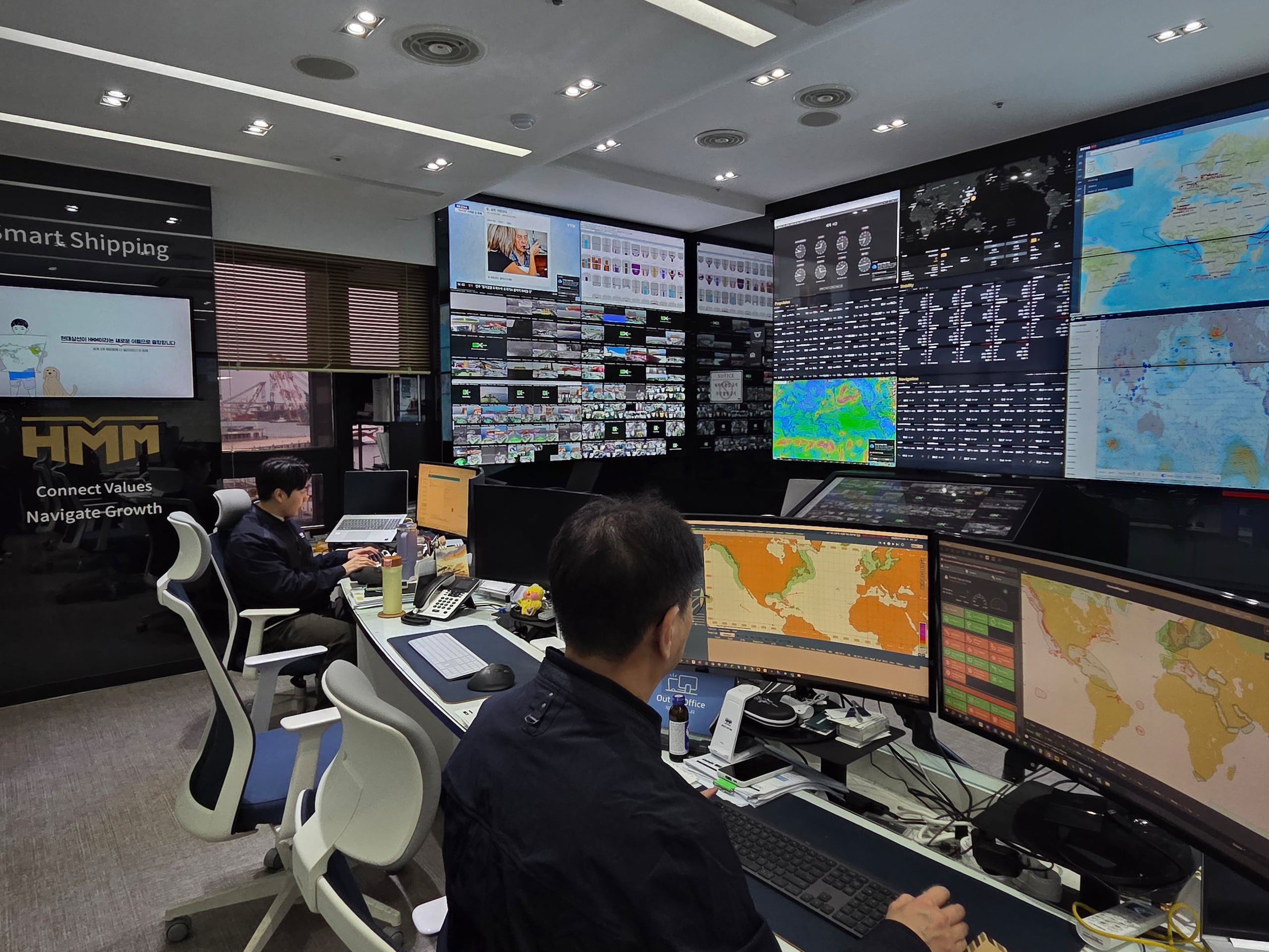
HMM's ship comprehensive situation room. /Courtesy of Han Ye-na
“It feels like we’ve gained one more savvy navigator for the long ocean-crossing voyage,” said Park Sang-hyun, the captain of the HMM Emerald, referring to the Hyundai Intelligent Navigation Assistant System (HiNAS), an AI-powered autonomous navigation solution, on Feb. 26.
Park, with 23 years at sea and nine years as a captain under his belt, said the system has proven its worth.
The 13,000-TEU container ship has been undergoing trial operations since November 2024 as the first HMM vessel to adopt HiNAS.
Park, with 23 years at sea and nine years as a captain under his belt, said the system has proven its worth.
The 13,000-TEU container ship has been undergoing trial operations since November 2024 as the first HMM vessel to adopt HiNAS.
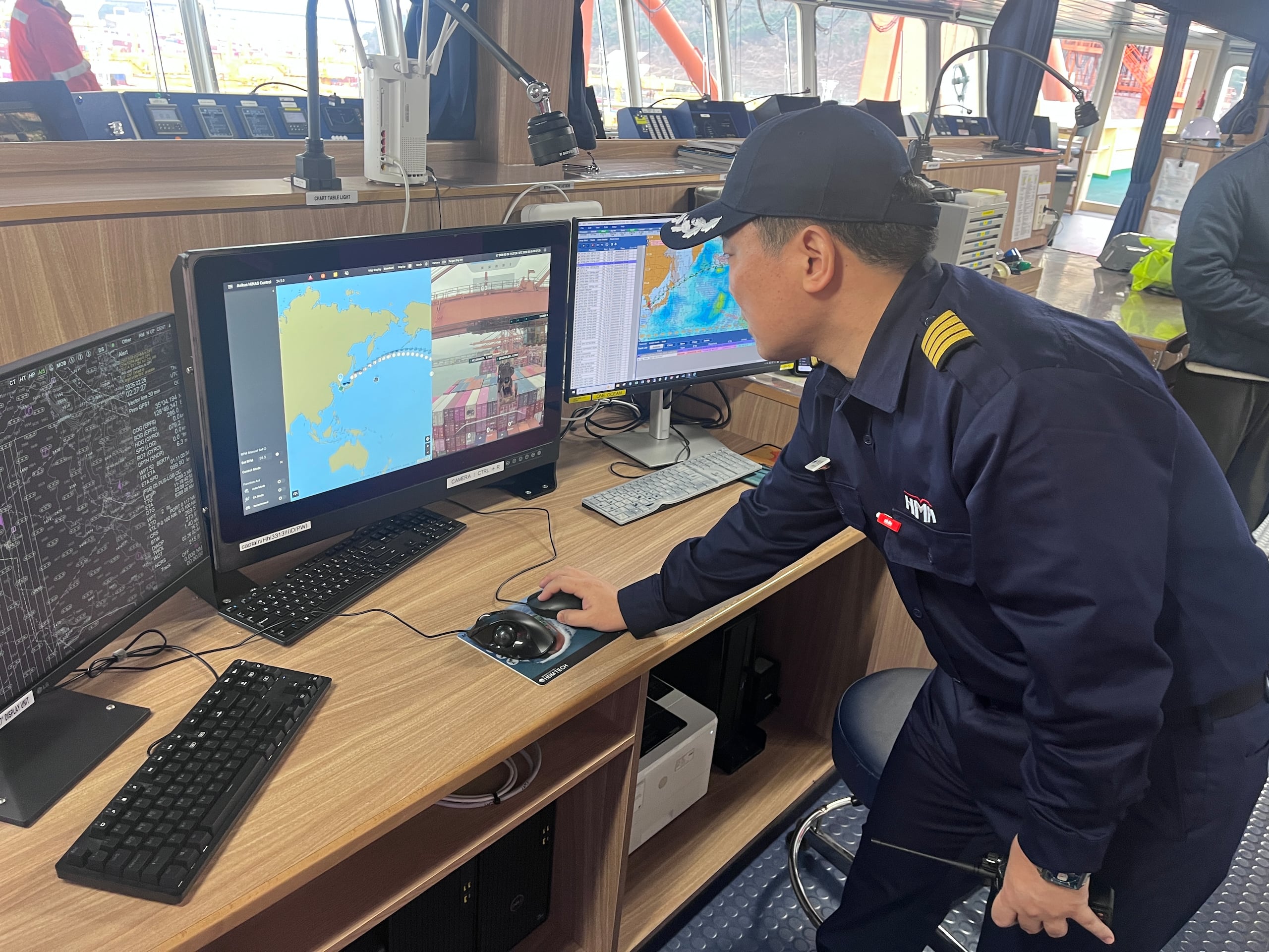
Captain Park Sang-hyun looks at the Avikus system in the bridge of the Emerald.
Courtesy of Han Ye-na
The system was developed by Avikus, an autonomous navigation firm under HD Hyundai Group, and has supported the ship on trips totaling 100,000 nautical miles (109,700 miles).
HMM plans to introduce HiNAS to 40 vessels by the end of this year.
The HMM Emerald, which operates an eight-week round trip between Busan and Los Angeles on a U.S. West Coast route, measures 335 meters (1,100 feet) long, 51 meters wide and 66 meters high, roughly comparable to a 10-story apartment building.
A total of 23 people are on board, including Korean deck and engine officers and Filipino crew members.
Stepping onto the ship, which had arrived at Busan Port overnight, the heavy smell of fuel lingered in the sea wind.
Stepping onto the ship, which had arrived at Busan Port overnight, the heavy smell of fuel lingered in the sea wind.
The highest point on board, the compass deck, was packed with observation equipment, such as radar detectors.

The Hyundai Intelligent Navigation Assistant System camera unit is located on the HMM Emerald’s topmost deck.
[KO SUK-HYUN]
There, the HiNAS navigation camera unit, a box-shaped device about
31 to 33 centimeters (12 to 13 inches) by 24 centimeters, is
installed.
“Six cameras — three optical and three infrared — serve as the ship’s eyes both day and night,” said Kim Hyeon-jae, a lead at Avikus.
“Using data [from the cameras], the AI keeps the vessel on its planned track and maintains its speed according to preset conditions.”
The collected data is transmitted via cables to the bridge, where the helm, charts and communications equipment are located.
The collected data is transmitted via cables to the bridge, where the helm, charts and communications equipment are located.
On a large monitor in the chart room, a video feed of real-time conditions in front of the ship appears alongside information regarding the route, speed, water depth, rudder angle and nearby vessels.

HMM’s container ship, the HMM Emerald, is berthed at Pier 4 of Busan New Port on Feb. 26.
[KO SUK-HYUN]
Jeon Tae-young, the HMM Emerald’s second officer, said HiNAS’s capabilities go beyond what earlier autopilots could do.
“The autopilot functions on existing ships largely focus on [the vessel’s direction],” Jeon said. “HiNAS can set an optimal route on its own and sail based on that route.”
“If the navigator inputs the desired arrival time for a destination, the system automatically calculates guidance for optimal engine revolutions per minute and speed by factoring in realtime weather and routing,” Jeon added.
“We’re working with the AI by analyzing a range of navigation data in real time to improve efficiency and keep precisely to the planned track.”
HiNAS also includes a collision avoidance function that detects other vessels and supports evasive maneuvers.
“When another ship enters a set range, [the system] alerts the navigator and, if necessary, can alter course to avoid it and then return to the original route,” Kim said.
HiNAS also includes a collision avoidance function that detects other vessels and supports evasive maneuvers.
“When another ship enters a set range, [the system] alerts the navigator and, if necessary, can alter course to avoid it and then return to the original route,” Kim said.

HMM Emerald second officer Jeon Tae-young uses the Hyundai Intelligent Navigation Assistant System’s “route planning” function to design a route from Busan Port to Los Angeles.
[KO SUK-HYUN]
Jeon said the feature is most useful in open-ocean stretches with little traffic, while manual control remains the norm in congested waters.
Pilot testing post-HiNAS adoption showed annual fuel savings of 2.5 to 4.5 percent, along with accompanying reductions in carbon emissions, according to HMM.
Pilot testing post-HiNAS adoption showed annual fuel savings of 2.5 to 4.5 percent, along with accompanying reductions in carbon emissions, according to HMM.
A large ship’s annual fuel bill typically runs about 10 billion to 20 billion won ($6.8 million to $13.6 million), and Avikus said fuel savings alone could allow the installation cost to be recovered within a year.
Full autonomy, however, remains a distant goal, in part because maritime rules are more complex than those on roads.
Full autonomy, however, remains a distant goal, in part because maritime rules are more complex than those on roads.
“HiNAS corresponds to Level 2 under the International Maritime Organization framework for Maritime Autonomous Surface Ships,” said Kim.
“Watchkeeping by crew remains essential, with collision-avoidance functions requiring a navigator’s judgment. Manual operation is also the default in heavily trafficked waters.”
Even so, the fact that AI has begun to participate in operating large commercial vessels that cross oceans is fueling expectations that autonomous navigation technology could spread across the industry.
“It’s not at the point where AI can stand watch in a navigator’s place,” Park said.
Even so, the fact that AI has begun to participate in operating large commercial vessels that cross oceans is fueling expectations that autonomous navigation technology could spread across the industry.
“It’s not at the point where AI can stand watch in a navigator’s place,” Park said.
“But it lets us focus on judgment and monitoring, which reduces the burden and improves safety. In the future, it could help ease seafarer shortages caused by a shrinking workforce.”
Links :
- Korea JoongAng Daily : HMM ship captain says AI autonomous navigation system has proven its worth
- The Chosun Daily : HMM's 335m Emerald Deploys World's First AI Navigation System
- Splash : HMM rolls out autonomous navigation tech across fleet
- DigitalShip : HMM scales autonomous navigation with Avikus
Tuesday, March 10, 2026
Sea Expandary's dual-track strategy : testing the waters in the awkward luxury goods market

Richard Liu, CEO and founder of China's e-commerce company JD.com

The announcement of the creation of the Sea Expandary shipyard in China, backed by an investment of around $700 million, goes beyond the simple launch of a new player aiming to establish itself in the yachting industry and then in recreational boating.
A yacht like a car? http://JD.com founder Liu Qiangdong launched Sea Expandary, a solo venture backed by 5 billion RMB ($690M) of his personal funds.
The goal? To disrupt the luxury status quo.
Liu aims to mass-produce spacious, high-quality yachts for as low as 100,000 RMB ($14,000)—making yachting as accessible as owning a car.
It is reminiscent of a scenario already seen in the automotive industry.
And the question deserves to be asked for European and American recreational boating.
From Pulse by Wei XIE
In my previous post, I shared my take on the 'dreamy' narrative of the 100,000-yuan yacht.
Now, let's dive into Sea Expandary's dual-track strategy.
Short-term (high-net-worth clients): The initial product line targets 60-120-foot mid-to-large luxury yachts, catering to corporate clients and high-net-worth individuals. This segment aims to accelerate capital recovery and establish brand premium. However, Sea Expandary holds virtually no competitive edge in the 60-120-foot luxury yacht market. The "short-term premium" component of its "dual-track strategy" appears more like a transitional narrative device than a viable commercial approach.
I.The " Small,Scattered and Weak"status of domestic yacht industry
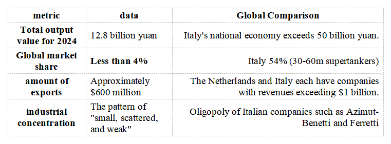
China's shipbuilding industry accounts for 55.7%-74.1% of the global merchant ship market share, but is completely silent in the "small boat" sector of yachts. This is not a problem of manufacturing capacity, but a comprehensive lag in branding, design, and experience definition.
II. Competitiveness Analysis of Existing Domestic Players
Major domestic yacht manufacturers
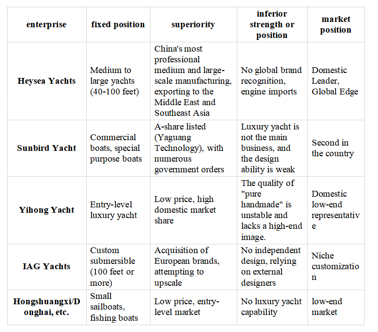
Common weaknesses:
III. Dissecting the "Advantages" of Sea Expandary: Story vs Reality
Advantage vs. real competitiveness
II. Competitiveness Analysis of Existing Domestic Players
Major domestic yacht manufacturers
Common weaknesses:
- Engine: 100% imported from Yamaha, Mercury, Volvo and other brands
- Design: No internationally renowned designer involved, with exterior and interior styling inspired by European aesthetics
- Brand: Without centuries of heritage, it cannot enter the high-end circles of Europe and America
- Certification: No International Yacht Association (IYBA) top-tier certification
III. Dissecting the "Advantages" of Sea Expandary: Story vs Reality
Advantage vs. real competitiveness

IV. The Real Competitive Landscape in the High-End Market
60-120 ft luxury yacht: Monopolized by European oligarchs
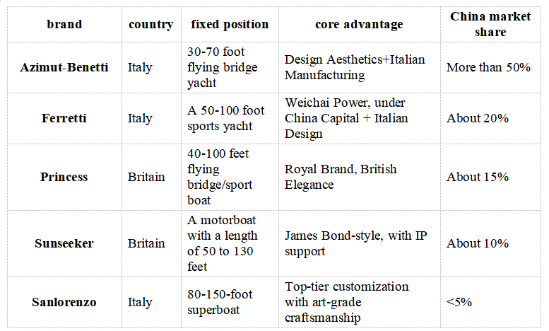
Sea Expandary's entry space: almost zero
Ⅴ. Why the "Short-term High-end" Strategy is Unfeasible?
1. Purchase logic of high-end customers
60-120 ft luxury yacht: Monopolized by European oligarchs
Sea Expandary's entry space: almost zero
- Technology: No in-house engine R&D capability, requiring imported components
- Design: No internationally renowned designer team
- Brand: JD.com's brand is unrelated to' luxury 'and may even command a premium (as affluent consumers avoid associating it with' express delivery brands').
- Service: No global after-sales service network (European brands have repair centers worldwide)
Ⅴ. Why the "Short-term High-end" Strategy is Unfeasible?
1. Purchase logic of high-end customers

For high-end clients, purchasing a yacht is about acquiring a status symbol rather than a means of transportation. Sea Expandary fails to deliver the integrated value of Italian design, European craftsmanship, and a century-old brand.
2. Comparison with Domestic Competitors
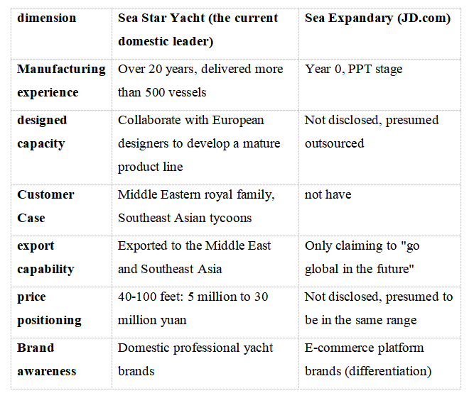
Sea Expandary's competitive edge over sea stars lies in its' 5 billion yuan capital 'and' Liu Qiangdong's IP,' yet neither translates into tangible product value or brand influence.
VI. The Real Purpose of the "Dual-track Strategy"
2. Comparison with Domestic Competitors
Sea Expandary's competitive edge over sea stars lies in its' 5 billion yuan capital 'and' Liu Qiangdong's IP,' yet neither translates into tangible product value or brand influence.
VI. The Real Purpose of the "Dual-track Strategy"

'Short-term premium' is not a business strategy but a narrative tactic
- No actual products (announced in March 2026, with the first ship not yet launched)
- No real customers (no orders disclosed)
- No genuine competitiveness (completely outpaced by European brands and inexperienced compared to domestic industry leaders)
In the untapped market, Sea Expandary remains a 'blank' area.
The Chinese yacht industry remains a 'blank slate' —lacking global brands, core technologies, and high-end recognition. Yet Sea Expandary has not filled this void, instead repeating JD.com's' follow-the-leader' strategy.
Sea Expandary's so-called' advantages 'in the 60-120-foot luxury yacht market are actually negative:
- it lacks European brand expertise, design innovation, and established reputation;
- it falls short of domestic leaders in experience, client base, and team building;
- its only' strength 'is a 5-billion-yuan investment and Liu Qiangdong's storytelling prowess.
Yet this is precisely the path dependence of underdog success stories: trading capital for time, stories for resources, and following for security. In the luxury yacht industry, which demands original designs, brand equity, and technological breakthroughs, this logic simply doesn't hold water.
As noted by Lu Xiao, Director of the International Premium Brand Strategy Research Institute: "The yacht industry's high value creation lies not merely in steel welding and hardware assembly, but in the fusion of material functionality and spiritual experience."
Sea Expandary lacks both differentiated material features (due to immature new energy technology) and the capacity to build spiritual experiences (with zero brand heritage).
The 'short-term premium' strategy is doomed to remain just a transitional slide in a PPT, never evolving into a viable business model.
The most important and fundamental point is:
The 'short-term premium' strategy is doomed to remain just a transitional slide in a PPT, never evolving into a viable business model.
The most important and fundamental point is:
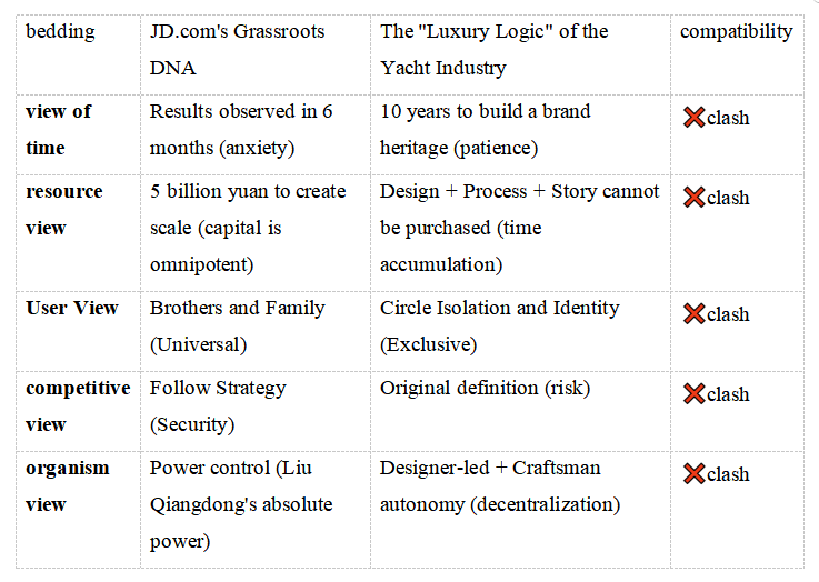
- The Incompatibility between "Express Brand" and "Luxury"
- The "Class Isolation" of Brand Cognition

- The Core Logic of Luxury: Distance and Exclusion
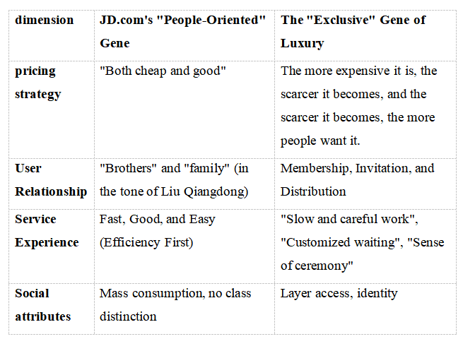
The core conflict lies in the fundamental difference between JD.com's 20-year philosophy of' efficiency for all 'and the' social stratification' mindset required by the yacht industry.
The Real Psychology of the Rich: What to Buy vs What to Skip
China high net worth individuals' yacht purchase decisions

Real-scene simulation:
Sanya Yacht Club: A conversation between rich man A and rich man B
A: "Just ordered an Azimut 72, an Italian-designed vessel with a Volvo engine, scheduled to sail to the Xisha Islands next week."
B: "That's great! I bought a new energy vehicle from JD with AI driving—it'll save me a fortune on fuel over the next 10 years."
A: (with an awkward smile) "Oh... JD.com does yachts too? That's great! What a great value for money!"
B: (sighing in frustration) "Did I really spend 20 million just to hear you say 'great value for money'?"
Historical Reference: The "Death Trap" of Brand Extension
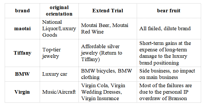
Sea Expandary's "No Chance"
I.Nine-dimensional Narrative Matrix Score (Full Score: 10)
Sanya Yacht Club: A conversation between rich man A and rich man B
A: "Just ordered an Azimut 72, an Italian-designed vessel with a Volvo engine, scheduled to sail to the Xisha Islands next week."
B: "That's great! I bought a new energy vehicle from JD with AI driving—it'll save me a fortune on fuel over the next 10 years."
A: (with an awkward smile) "Oh... JD.com does yachts too? That's great! What a great value for money!"
B: (sighing in frustration) "Did I really spend 20 million just to hear you say 'great value for money'?"
Historical Reference: The "Death Trap" of Brand Extension
Sea Expandary's "No Chance"
I.Nine-dimensional Narrative Matrix Score (Full Score: 10)

Overall score: 1.8/10-Lacks any sustainable competitive advantage
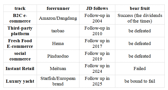
II. Comparison with JD's Past Failed Projects
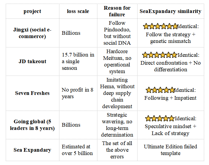
III. Prediction of the "Evaporation Path" of 5 Billion Yuan
Year 1-2: Storytelling and Financing
IV. The Only Possible "Path to Survival" (Probability <5%)
II. Comparison with JD's Past Failed Projects
III. Prediction of the "Evaporation Path" of 5 Billion Yuan
Year 1-2: Storytelling and Financing
- Terminal construction (Shenzhen, Zhuhai): 2 billion yuan (heavy asset, no return)
- Team building + design outsourcing: 500 million (no core capability accumulation)
- Marketing PR ("China Yacht Dream"): 500 million (public opinion heat = orders)
- First batch of 2-3 prototype ships: 1 billion (no customer orders, purely for display)
- High-end customers have zero orders (brand recognition failure)
- Turn to "Inclusive Yacht" (100,000 Yuan Class), Discover the Paradox of Holding Cost
- New energy technology failures (battery weight increase, range anxiety)
- Policy Subsidy Rollback (The Narrative of Common Prosperity Fails)
- Asset disposal: Transfer of wharf operation rights (at a discount of 50%)
- Team Dissolution: Lack of Industry Experience and Talent Drain
- Best-case scenario: Integration into JD Logistics (as a "water-based express" pilot project?)
- Estimated recovery rate: 20-30% (1-1.5 billion) Estimated net loss: 3.5-4 billion
IV. The Only Possible "Path to Survival" (Probability <5%)

V. Core Conclusion: Why "No Chance of Success"?
Sea Expandary is not a commercial venture, but a narrative-driven storytelling tool: it frames policy narratives through 'common prosperity + new energy', capital narratives via '5 billion yuan investment', and trust-building narratives by leveraging the JD brand.
Yet all three narratives are false:
- The public cannot afford it (actual annual cost exceeds 160,000 yuan)
- The government sees no need (lacks strategic value, purely consumer-driven)
- The brand is untenable (express delivery and luxury are mutually exclusive)
Even if 5 billion ordinary people squandered their wealth, it would take them generations to exhaust it. For Liu Qiangdong, this merely reflects 'fluctuations in trust asset valuations'; but for Shenzhen and Zhuhai governments and potential future shareholders, this represents a genuine wealth transfer.
These 5 billion are not 'investment' but 'consumption' —a purchase of a 'captain's dream 'narrative, where the protagonist has already secured a' never-drowning' lifeboat through offshore structures.
Links :
Monday, March 9, 2026
Sentinel-1's decade of essential data over shifting ice sheets

The extent and speed of ice moving off the ice sheets of Greenland and Antarctica into the sea – an important dynamic for climate and sea-rise modelling – has been captured over a 10-year period by satellites from the Copernicus Sentinel-1 mission.

The mission’s observations now span a decade, starting in 2014, and provide the first continuous, high-resolution record of the ice-flow velocities across the Greenland and Antarctica ice sheets.
This long-term dataset, published as a study in Remote Sensing of Environment journal, is based on advanced processing of radar data from Sentinel-1’s synthetic aperture radar (SAR) instrument.
The study is part of a collection of academic papers curated by ESA to mark the 10-year anniversary of the Sentinel-1 mission.
The special issue underlines the importance of long-term and high-resolution datasets for many applications, including monitoring the changes in ice sheets in Greenland and the Antarctic.

Ice velocity on Antarctica
The data visualisation of Antarctica (see image on the left) shows details of ice flows moving at speeds between 1 m and 15 m per day.
The Sentinel-1 data is averaged over the period 2014–2024.
Regions shown on the map include the Antarctic Peninsula and Alexander Island, as well as large parts of the West Antarctic Ice Sheet and East Antarctic Ice Sheet.
Most of the coastal areas were captured at either six or 12-day intervals.
On the West Antarctic Ice Sheet (on the left of the image), the Pine Island Glacier is clearly visible below the Antarctic Peninsula.
On the West Antarctic Ice Sheet (on the left of the image), the Pine Island Glacier is clearly visible below the Antarctic Peninsula.
Over the period of the study, the velocity of ice flow at the glacier’s grounding line – the point where grounded ice detaches from the bedrock underneath it and becomes a floating ice shelf – increased continuously from approximately 10.6 m per day to 12.7 m per day.
Other nearby glaciers also showed increased ice flow.
These changes are caused by a range of factors including ocean-induced thinning of the floating ice shelves combined with a retreat of the grounding line.

Greenland’s ice flows
The study shows the rapid flow of ice, moving at average speeds of up to 15 m per day, from glaciers and ice sheets at points around the Greenland Ice Sheet (see image on the right). Half-way up the western coast of Greenland, Sermeq Kujalleq, also known as the Jakobshavn Glacier, is one of the fastest outlet glaciers in the world with velocities reaching, at times, as much as 50 m per day (see a zoomed-in map below).
The North-East Greenland Ice Stream (NEGIS), is also clearly visible on the Greenland Ice Sheet and begins far inland at the ‘ice divide’, shown as a dark blue band of nearly stagnant ice in Greenland’s interior.
The dataset offers unprecedented spatial detail, with resolution up to 200–250 m, as well as timeframes for tracking movement ranging from less than a week to more than a decade.
Mapping the effects of climate change
Ice velocity is a key parameter in measuring the effects of climate change.
The speed at which glaciers and ice sheets move tells us the rate at which they discharge ice and water into the sea, feeding into estimations on future sea-level rise.
Data on ice velocity also help to keep track of the break-up of ice sheets, such as calving events or damage to the ice sheets.
Strengthening the ability to monitor ice dynamics is vital for refining predictions of future changes in ice sheets and glaciers, their impact on sea-level rise, and their broader effects on the climate.
Lead-author of the study, Jan Wuite, of ENVEO IT, noted the impact made by the Copernicus Sentinel-1 mission to monitoring ice flow movements.
He said, “Before the launch of Sentinel-1, the absence of consistent SAR observations over polar glaciers and ice sheets posed a major barrier to long-term climate records.
Today, the resulting velocity maps offer an extraordinary view of ice-sheet dynamics, providing a reliable and essential data record for understanding polar regions in a rapidly changing global climate.”
The annual ice velocity products for Greenland and Antarctica are operationally generated within the Copernicus Climate Change Service (C3S) for the cryosphere domain, which is led by ENVEO.
The annual ice velocity products for Greenland and Antarctica are operationally generated within the Copernicus Climate Change Service (C3S) for the cryosphere domain, which is led by ENVEO.
Joaquín Muñoz Sabater, the responsible scientist at the European Centre for Medium-Range Weather Forecasts (ECMWF) for the C3S cryosphere service, stated, “The ice velocity time series for Antarctica and Greenland are an essential component of the C3S Cryosphere Service and a key contribution to monitoring the impacts of global warming in some of the world’s most sensitive regions.”
Step change in polar observation
Since its first satellite was launched in 2014, the Copernicus Sentinel-1 mission has provided a step change in the capabilities of polar satellite Earth observation. Its 12-m-long advanced SAR instrument works in C-band.
Step change in polar observation
Since its first satellite was launched in 2014, the Copernicus Sentinel-1 mission has provided a step change in the capabilities of polar satellite Earth observation. Its 12-m-long advanced SAR instrument works in C-band.
This makes it a reliable tool for acquiring high-resolution imagery for continuous monitoring and emergency response efforts. It is able to capture data through cloud cover, smoke and during lack of sunlight

Nuno Miranda, ESA’s Sentinel-1 Mission Manager, explained, “Before Sentinel-1, generating such results required combining data from multiple sensors over several years.
With Sentinel-1, these results are now produced annually and, thanks to advances in science, even monthly.
This breakthrough enables monitoring of these remote areas with unprecedented temporal resolution. It is an essential tool as 2025 marks another record-breaking year of Arctic warming, where rapid changes demand closer and more frequent observation.”
The mission has enabled, for the first time, the generation of large-scale, dense and continuous time series of polar ice velocity for climate research.
The mission has enabled, for the first time, the generation of large-scale, dense and continuous time series of polar ice velocity for climate research.
The mission has also enabled the application of Interferometry SAR (InSAR) for ice velocity retrieval on larger scales than before.
It provides a systematic acquisition strategy for the polar regions, which ensures continuous coverage of the main sectors of the Greenland and Antarctic ice sheets, as well as of other ice masses.
With the launch of the mission’s fourth satellite – Sentinel-1D – at the end of 2025, the mission’s capacity to provide regular acquisitions every six days or less over Greenland and Antarctica is restored. This reinstates and even enhances the capabilities that existed before the breakdown of Sentinel-1B.
Using the extensive Sentinel-1 SAR archive, the authors of the study developed algorithms to generate detailed maps and dense time series of glacier and ice sheet velocity now spanning more than 10 years. The study’s results show Sentinel-1’s exceptional ability to comprehensively monitor flow velocities on glaciers and ice sheets, providing crucial data for ice dynamics and climate modelling
Why does it matter?
The rise of global sea levels depends on two main contributing factors, according to data from the World Meteorological Organization.
These two factors are the expansion of warming water in the oceans and meltwater from ice on land. The Antarctic and Greenland ice sheets are the main sources of meltwater from ice on land; together they hold enough ice to raise global sea levels catastrophically if they were to melt entirely.
Current ice mass loss is already affecting coastal regions worldwide, including low-lying areas vulnerable to flooding and storm surges.
This study underscores how satellites are essential to understanding and forecasting the evolving risk from ice sheet loss.
This study underscores how satellites are essential to understanding and forecasting the evolving risk from ice sheet loss.
It is the first time that scientists have established a consistent, continent-wide baseline of how the ice of Greenland and Antarctica moves under recent conditions.
That baseline will help detect future acceleration, or any deceleration, of ice flow.
Looking ahead to collaboration
In future, data from Sentinel-1 will be used with SAR data from the upcoming Copernicus expansion mission ROSE-L.
In future, data from Sentinel-1 will be used with SAR data from the upcoming Copernicus expansion mission ROSE-L.
This will ensure systematic, continuous acquisitions over Greenland and Antarctica well into the future.
CEO of ENVEO IT, Thomas Nagler, also a co-author on the study, added, "Sentinel-1 revolutionised our view of polar ice sheets by providing continuous, weather-independent radar measurements that reveal ice motion in unprecedented detail, transforming ice flow from a sparse snapshot into a dynamic, measurable process.
CEO of ENVEO IT, Thomas Nagler, also a co-author on the study, added, "Sentinel-1 revolutionised our view of polar ice sheets by providing continuous, weather-independent radar measurements that reveal ice motion in unprecedented detail, transforming ice flow from a sparse snapshot into a dynamic, measurable process.
Building on this legacy, the integration of Sentinel-1 with the upcoming ROSE-L mission will further improve ice-flow observations, enabling more accurate and stable monitoring of ice-sheet dynamics.”
Links :
Sunday, March 8, 2026

Subscribe to:
Posts (Atom)