
Two vessels rendezvous off the coast of Argentina in a likely transshipment.
(DigitalGlobe © 2017)
From Smithsonian Mag by Emily Matchar
Global Fishing Watch is using satellite data to monitor suspicious ship activity on the high seas
In many ways, the ocean is the Wild West.
The distances are vast, the law enforcement agents few and far between, and the legal jurisdiction often unclear. In this environment, illegal activity flourishes.
Illegal fishing is so common that experts estimate as much as a third of fish sold in the U.S. was fished illegally.
This illegal fishing decimates the ocean’s already dwindling fish populations and gives rise to modern slavery, where fishermen are tricked onto vessels and forced to work, sometimes for years.
A new use of data technology aims to help curb these abuses by shining a light on the high seas.
The technology uses ships’ satellite signals to detect instances of transshipment, when two vessels meet at sea to exchange cargo.
As transshipment is a major way illegally caught fish makes it into the legal supply chain, tracking it could potentially help stop the practice.
“[Transshipment] really allows people to do something out of sight,” says David Kroodsma, the research program director at Global Fishing Watch, an online data platform launched by Google in partnership with the nonprofits Oceana and SkyTruth.
“It’s something that obscures supply chains. It’s basically being able to do things without any oversight. And that’s a problem when you’re using a shared resource like the oceans.”
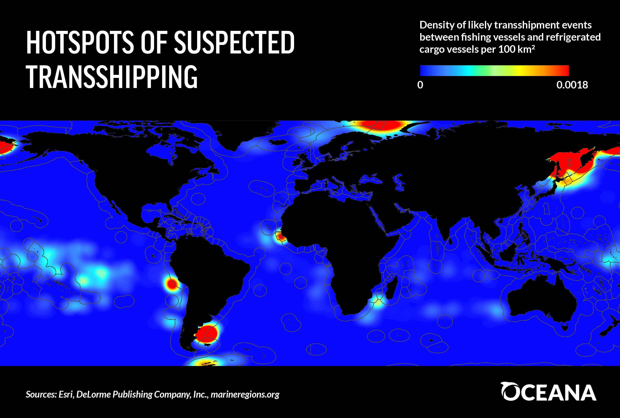
Patterns of global hotspots of likely transshipping in more detail
Global Fishing Watch analyzed some 21 billion satellite signals broadcast by ships, which are required to carry transceivers for collision avoidance, from between 2012 and 2016.
It then used an artificial intelligence system it created to identify which ships were refrigerated cargo vessels (known in the industry as “reefers”).
They then verified this information with fishery registries and other sources, eventually identifying 794 reefers—90 percent of the world’s total number of such vessels.
They tracked instances where a reefer and a fishing vessel were moving at similar speeds in close proximity, labeling these instances as “likely transshipments,” and also traced instances where reefers were traveling in a way that indicated a rendezvous with a fishing vessel, even if no fishing vessel was present—fishing vessels often turn off their satellite systems when they don’t want to be seen. All in all there were more than 90,000 likely or potential transshipments recorded.
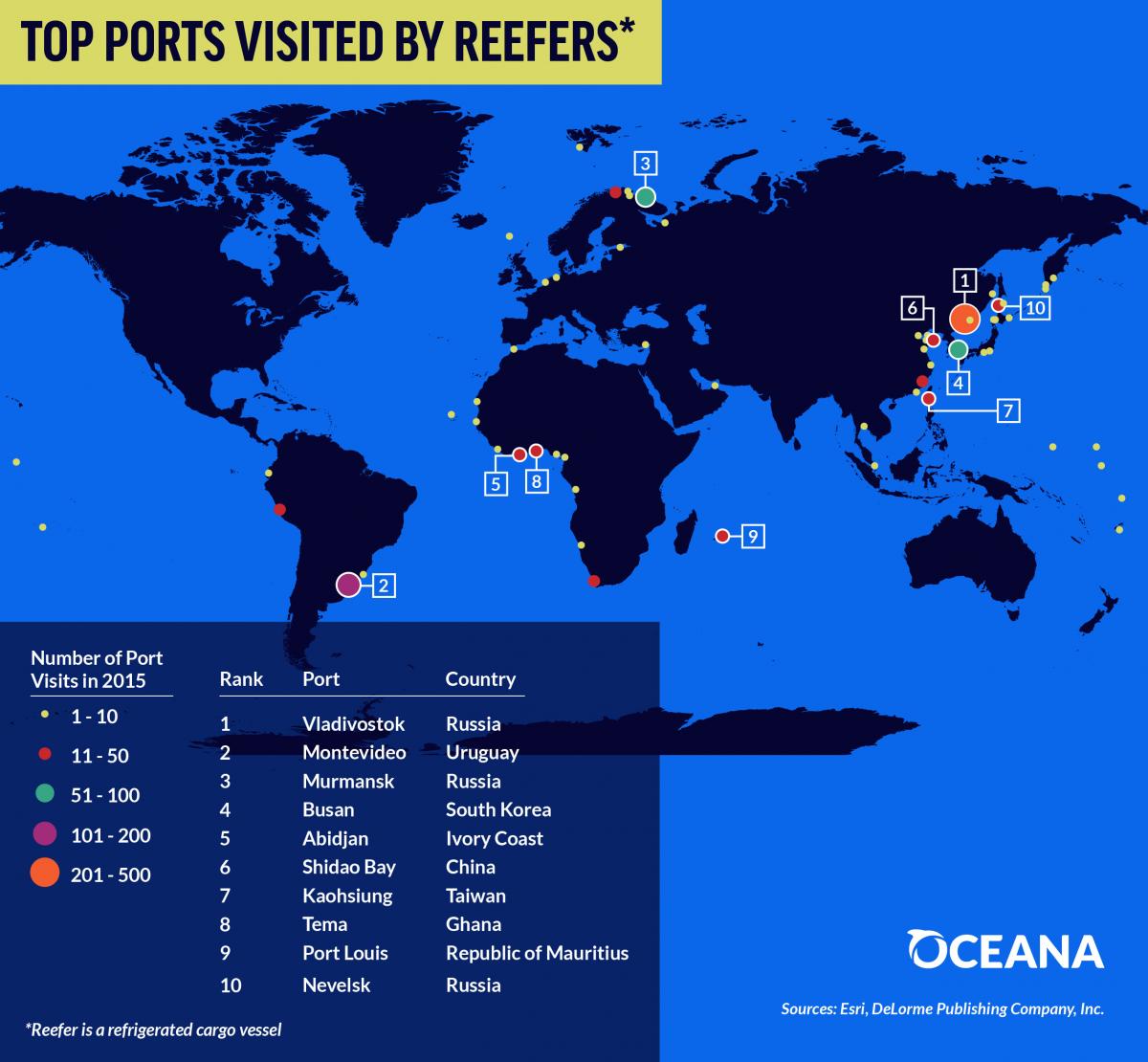
Top 10 ports visited by refrigerated cargo vessels likely involved in transshipping.
Even if these encounters were in fact transshipments, they would not all have been for nefarious purposes. They may have taken place to refuel or load up on supplies.
But looking at the patterns of where the potential transshipments happen is revealing.
Very few are seen close to the coasts of the U.S., Canada and much of Europe, all places with tight fishery regulations.
There are hotspots off the coast of Peru and Argentina, all over Africa, and off the coast of Russia. Some 40 percent of encounters happen in international waters, far enough off the coast that no country has jurisdiction.
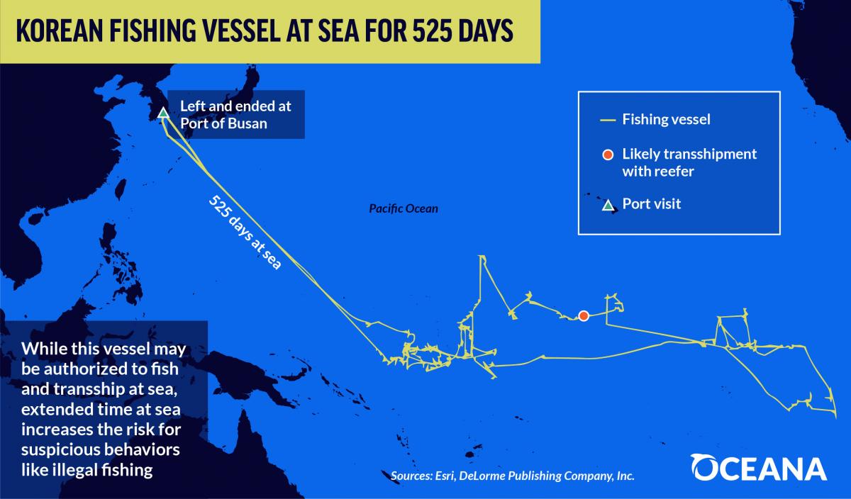
Korean fishing vessel at sea for more than 500 days.
 Track of the Leelawadee (red) and an unnamed fishing vessel (white) rendezvousing in Papua New Guinea waters in July 2015, then again on the Saya de Malha bank in November 2016.
- courtesy of SkyTruth -

- courtesy of SkyTruth -
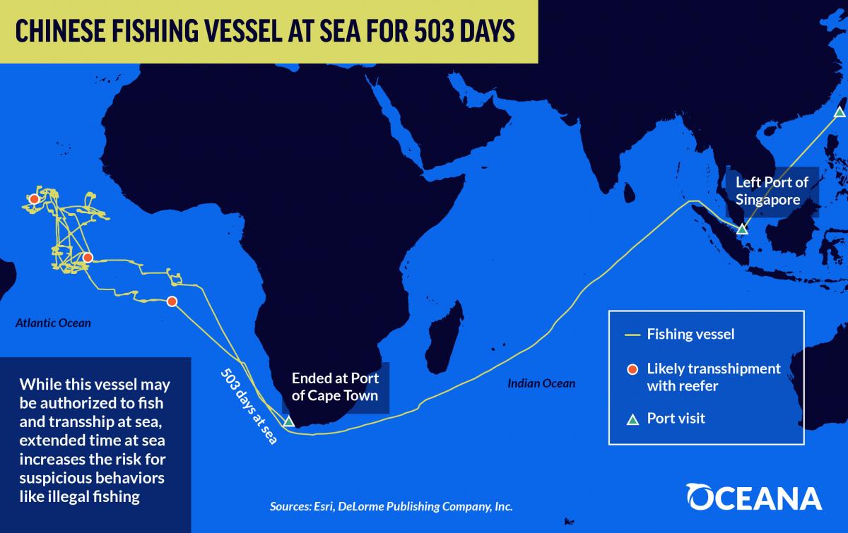
Chinese fishing vessel at sea for more than 500 days.
But that doesn’t necessarily tell us much about where they really come from.
Nearly half of the reefers tracked were flying “flags of convenience,” meaning they’re registered in countries other than where the ship’s owners are from to take advantage of those countries’ lax regulations.

In November 2016, the refrigerated cargo
vessel (reefer) Leelawadee was seen with two unidentified likely fishing
vessels tied alongside it in the Indian Ocean, off the remote Saya de
Malha bank.
(DigitalGlobe © 2017)
This project wouldn’t have been possible until quite recently, Kroodsma says.
“Five years ago, there weren’t enough satellites, and now they’re launching more and more.
And you need some really big data infrastructure—cloud computing and machine learning technologies that really didn’t exist in the same scalable, economical way.”
Machine learning is becoming a powerful and important aspect of analytics workloads.
Amy Unruh and David Kroodsma look at how the Global Fishing Watch project has used Google Cloud Dataflow analytics, Google Cloud Machine Learning, and BigQuery to help monitor and reduce overfishing across the world.
In the process, they show you how you can use Dataflow to transform a data stream for distributed training of a deep neural net on the Cloud Machine Learning platform, and use Cloud Machine Learning's support for hyperparameter tuning to optimize performance of the model.
You'll also learn how you can access trained models for prediction from Cloud Dataflow pipelines, using Cloud Machine Learning's scalable serving, to augment your pipeline's analytical capabilities.
Kroodsma hopes Global Fishing Watch’s data, all of which is freely available, will be useful to third parties interested in regulating illegal fishing.
That might include regional fishery management organizations, researchers and ordinary citizens.
“We’re really empowering others who know more than we do,” he says.
Hopefully, Kroodsma says, this will translate into fewer illegally caught fish on our plates.
“It’s something that’s no longer out of sight,” he says.
“People are going to have to account for where they’re getting their fish.”
Links :
- Business Insider : Satellites expose the biggest hotspots of illegal transshipping
- DiscoverMag : Help fight illegal fishing with Global Fishing Watch
- Oceana : No more hiding at sea : transshipping exposed
- SkyTruth : Satellites Leave No Place to Hide for Rogue Thai Fishing Fleet
- Global Fishing Watch : The First-Ever Global View of Transshipment in Commercial Fishing
- GeoGarage blog :Global Fishing Watch lets you track 35000 fishing boats ... / Google's global fishing watch is using 'manipulated data' / Eyes in the sky: Green groups are harnessing data from ... / How satellites and big data can help to save the oceans / How satellite technology is helping to fight illegal fishing / Google's global fishing watch is using 'manipulated data' / The plan to map illegal fishing from Space
The Maritime Executive : Using Satellite Imagery to Combat Illegal Fishing (ImageSat International)
ReplyDeleteNasdaq : How Can Advanced Technologies Combat Illegal Fishing
ReplyDelete