
The calving front of Thwaites Ice Shelf photographed from the IceBridge research plane.
The water acts as a blue filter for ice visible below the water's surface.
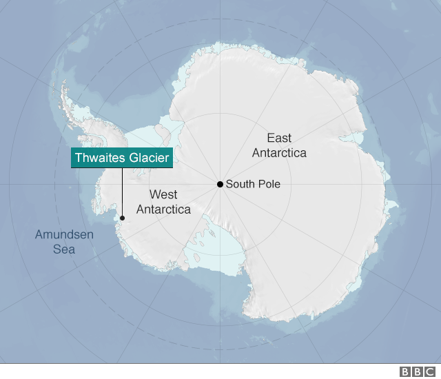
Thwaites Glacier flows into Pine Island Bay, in West Antarctica.
Credit: NASA / Jim Yungel
From BBC by Jonathan Amos
It is going to be one of the biggest projects ever undertaken in Antarctica.
UK and US scientists will lead a five-year effort to examine the stability of the mighty Thwaites Glacier.

Thwaites glacier with the GeoGarage platform (NGA chart)
This ice stream in the west of the continent is comparable in size to Britain.
It is melting and is currently in rapid retreat, accounting for around 4% of global sea-level rise - an amount that has doubled since the mid-1990s.
Researchers want to know if Thwaites could collapse.
Were it to do so, its lost ice would push up the oceans by 80cm or more.
Timelapse satellite images of Thwaites Glacier melting
Some computer models have suggested such an outcome is inevitable if conditions continue as they are - albeit on a timescale of centuries.
But these simulations need to be anchored in many more real-world observations, which will now be acquired thanks to the joint initiative announced on Monday.
"There is still a question in my view as to whether Thwaites has actually entered an irreversible retreat," said Prof David Vaughan, the director of science at the British Antarctic Survey.
"It assumes the melt rates we see today continue into the future and that's not guaranteed.
Thwaites is clearly on the verge of an irreversible retreat, but to be sure we need 10 years more data," he told BBC News.
The UK's Natural Environment Research Council and the US National Science Foundation are going to deploy about 100 scientists to Thwaites on a series of expeditions.

Copyright NERC, Ben Gilliland
The International Thwaites Glacier Collaboration (ITGC) is the two nations' biggest cooperative venture on the White Continent for more than 70 years - since the end of a mapping project on the Antarctic Peninsula in the late 1940s.
Grants for research totalling £20m have been awarded.
Once the costs of transport and resupply to this remotest of regions is factored in, the total value of the ITGC will probably top £40m.
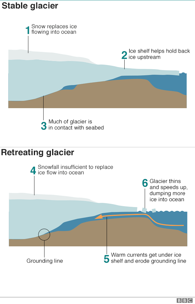
Thwaites is a marine-terminating glacier.
Snows fall on land and these compact into ice that then flows out to sea.
When in balance the quantity of snow at the glacier's head matches the ice lost to the ocean at its front through the calving of icebergs.
But Thwaites is out of balance.
It has speeded up and is currently flowing at over 4km per year.
It is also thinning at a rate of almost 40cm a year.
"When we look at the historical satellite record we can see that this thinning started after 2000, spreading inland at a rate of 10-12km/year at its fastest," explained Dr Anna Hogg from Leeds University.
"So on Thwaites Glacier, the increase in ice speed has coincided with a period of rapid ice thinning, and grounding line retreat, which suggests that the observed changes may have been caused by warm ocean water reaching the glacier and accelerating ice melt."

Map showing rates of grounding-line migration and their coincidence with ocean conditions around Antarctica between 2010 and 2016.
(Credit: Hannes Konrad et al, University of Leeds.)
The grounding line refers to the zone where the glacier enters the sea and lifts up to form a buoyant platform of ice.
If warm ocean bottom-waters are able to get under this shelf, the grounding line can be eroded and the glacier forced backwards even if local air temperatures are sub-zero.
Key to this process in the case of Thwaites is that a large portion of the ice stream sits below sea level, with the rock bed sloping back towards the continent.

Image of Thwaites Glacier shot during a reconnaissance flight in West Antarctica.
(Photo courtesy of the National Science Foundation)
This can produce what scientists refer to as "marine ice sheet instability" - an inherently unstable architecture, which, once knocked, can go into an irreversible decline.
"The other process we're concerned about is something called marine ice cliff instability," said Dr Ted Scambos, the principal coordinating investigator on the US side of the project from the National Snow and Ice Data Center.
"This is where a tall cliff that might form at the front of the glacier begins to calve - begins to break away - in a runaway fashion.
It hasn't been seen yet in this part of Antarctica; it might be present in some parts of the Antarctic Peninsula, but around Greenland seems to be a path to a very rapid retreat of the ice front."
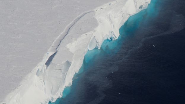
The floating front of the glacier is hundreds of metres thick
photo : EMPICS
The ITGC aims to determine how all of this will play out for Thwaites.
Its scientists will map the ice stream's every behaviour.
They will monitor the way ocean water moves beneath the floating shelf, and drill sediments from under and just in front of the glacier to find out what it did during past warming events on Earth.
The work will involve multiple instruments and techniques, including the use of autonomous vehicles.
The yellow submarine known as Boaty McBoatface is expected to explore the cavity under the buoyant sections of Thwaites.
Seals will also be assisting the research.
Prof Karen Heywood from the University of East Anglia, working in tandem with St Andrews University, will be attaching sensors to the heads of the animals.
She told BBC News: "The seals dive in the course of their normal life and every time they come to the surface to breathe, the data are transmitted back home.
The seals monitor their own environment - where they went, how deep they dived, and how warm the water was they were diving in.
At the end of the year, they moult and the tag falls off, so they don't have to live with it forever."
Prof Vaughan said that while the UK and America were leading the project, he thought other countries would want to get involved.
"Funding from NERC and NSF has set this train in motion, but I fully expect other nations now to join their carriages."
Links :
- BBC : Antarctica 'gives ground to the ocean' / 'Boaty McBoatface' survives ice mission / Ice loss spreads up Antarctic glaciers
- The Guardian : Boaty McBoatface leads £20m mission to melting Antarctic glacier
- Washington Post : An alarming 10 percent of Antarctica’s coastal glaciers are now in retreat, scientists find
- NYTimes : In Antarctica, Two Crucial Glaciers Accelerate Toward the Sea
- Scientific American : Antarctic Glaciers Lost Stunning Amount of Ground in Recent Years
- NewsDeeply : High-Stakes Oceanography at Antarctica’s Dangerously Thinning Glacier
- NASA : A block of Thwaites
The Guardian : Global warming is melting Antarctic ice from below
ReplyDeletegiven most of the sea ice around Antarctica melts each year it would be good to see images winter max and summer minimum each year - comparisons of change would then be visible. Its easy to get film of a melting ice sheet, just use summer images, but this is normal for Antarctica
ReplyDelete