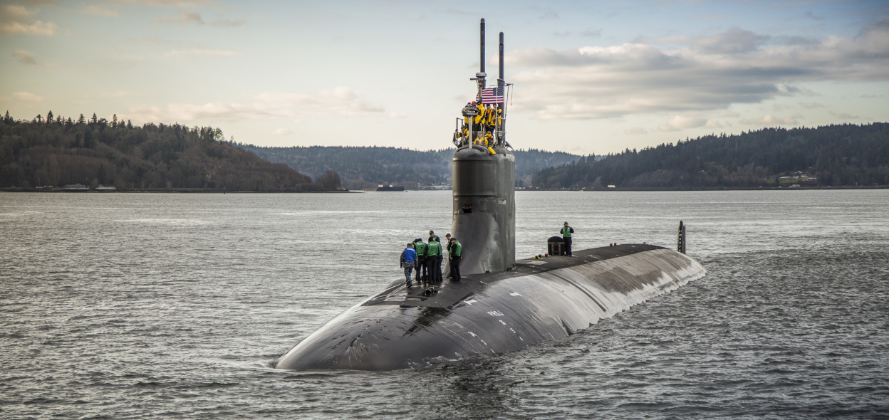
The Seawolf-class fast-attack submarine USS Connecticut (SSN 22) departs Puget Sound Naval Shipyard for sea trials following a maintenance availability.
Photo: Thiep Van Nguyen / U.S. Navy
From FoxWeather by Aaron Barker
Water covers about 71% of the planet and oceans hold about 96% of that water, according to the United States Geological Survey.
Underneath all that water lies worlds unto their own – towering mountains, cavernous trenches and plains in between.
Underneath all that water lies worlds unto their own – towering mountains, cavernous trenches and plains in between.
As it turns out, we don’t know as much about the underwater part of Earth as many would think.
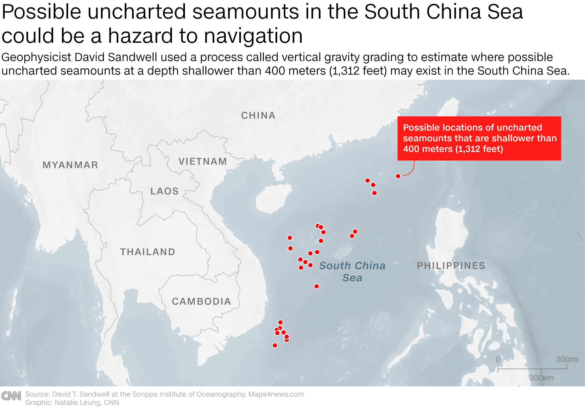
The USS Connecticut, an attack submarine, ran into one of those mountains late last year in the South China Sea.
The USS Connecticut, an attack submarine, ran into one of those mountains late last year in the South China Sea.
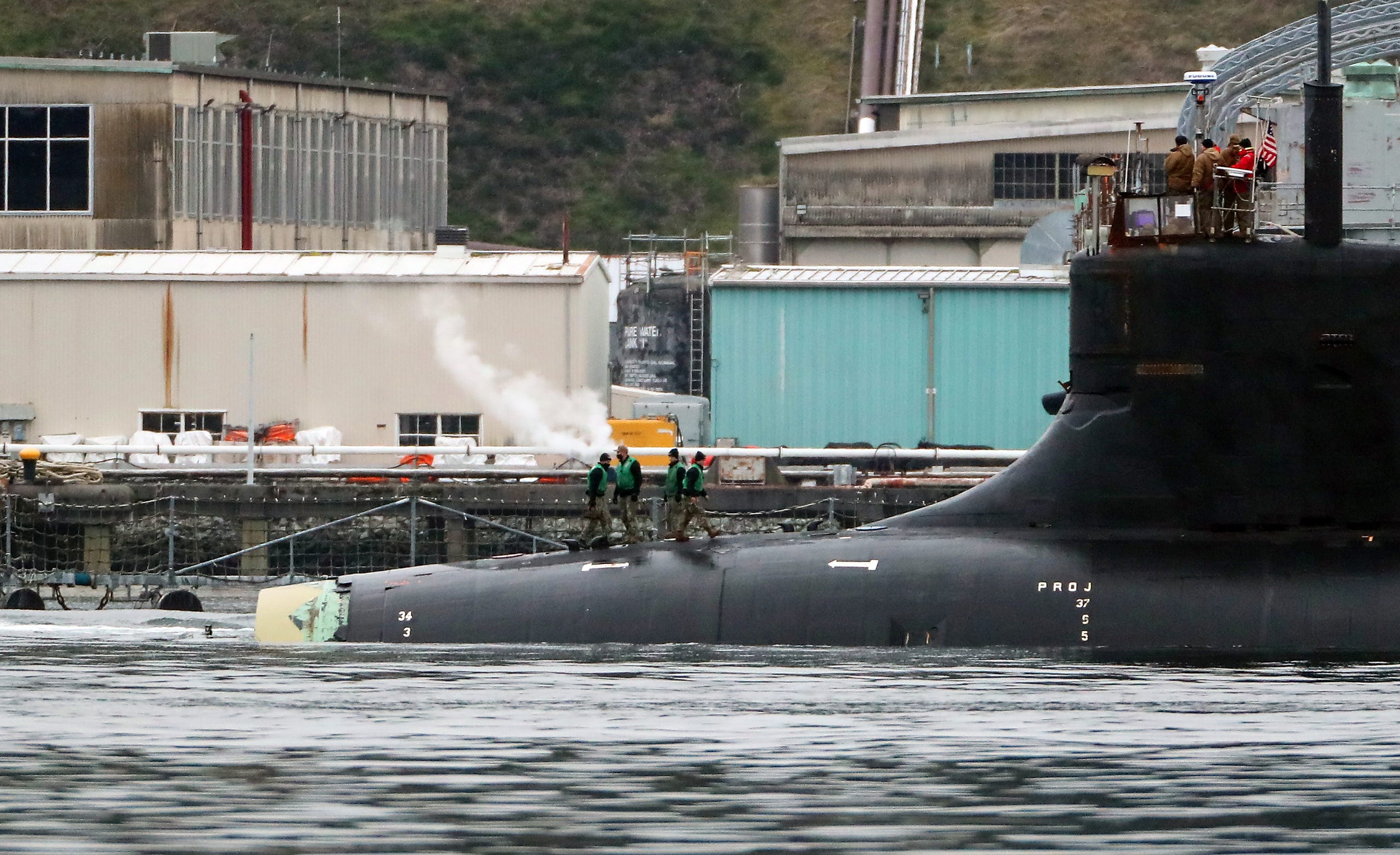
The USS
Connecticut, which had its sonar dome damaged in a collision with an
underwater seamount, pulls into Naval Base Kitsap-Bremerton
Meegan M. Reid/Kitsap Sun
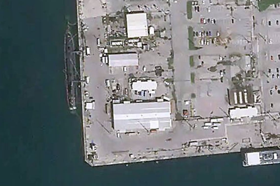
A satellite image shows the USS Connecticut nuclear submarine moored in Guam for receiving prelimanary repairs.
Photo: Weibo
The Navy Times reported last week that the sub's sonar dome and main ballast tanks were damaged. Navy officials said "adherence to required procedures in navigation planning" was one of the things that could have prevented the collision, according to USNI News.
Glen Rice, a physical scientist with NOAA’s Ocean Service and the Office of Coast Survey, said that he doesn't know why the Connecticut ran aground, but did say there is plenty about the ocean floor that we still don't know.
"There's a, you know, a common saying: We know more about the surface of Mars than we do about, you know, the deep ocean on our own planet," Rice said.
Rice is part of a team at NOAA whose job it is to develop maps of the sea floor and allow vessels to safely navigate the water.
He said there is a plethora of instruments scientists use to survey the ocean floor, such as sonar, lasers, airplanes and satellites.
It all depends on how much detail is desired and the depth of the ocean floor.
"You could also use satellite-derived imagery, which is using more like pictures, and you're using kind of how the light changes as it goes through the water," Rice said.
"You could also use satellite-derived imagery, which is using more like pictures, and you're using kind of how the light changes as it goes through the water," Rice said.
"As you move away from that really shallow-water environment or in places where it's murky, you really need to use sound a lot of the time because that penetrates much better."
What’s down there?
The tallest mountain on Earth actually has its start underwater.
Mount Everest holds the title as the tallest mountain above sea-level at just more than 29,000 feet.
However, the tallest mountain on the planet is Mauna Kea, a volcano on the Big Island of Hawaii.
According to NOAA, Mauna Kea is 33,500 feet tall from its base on the floor of the Pacific Ocean.
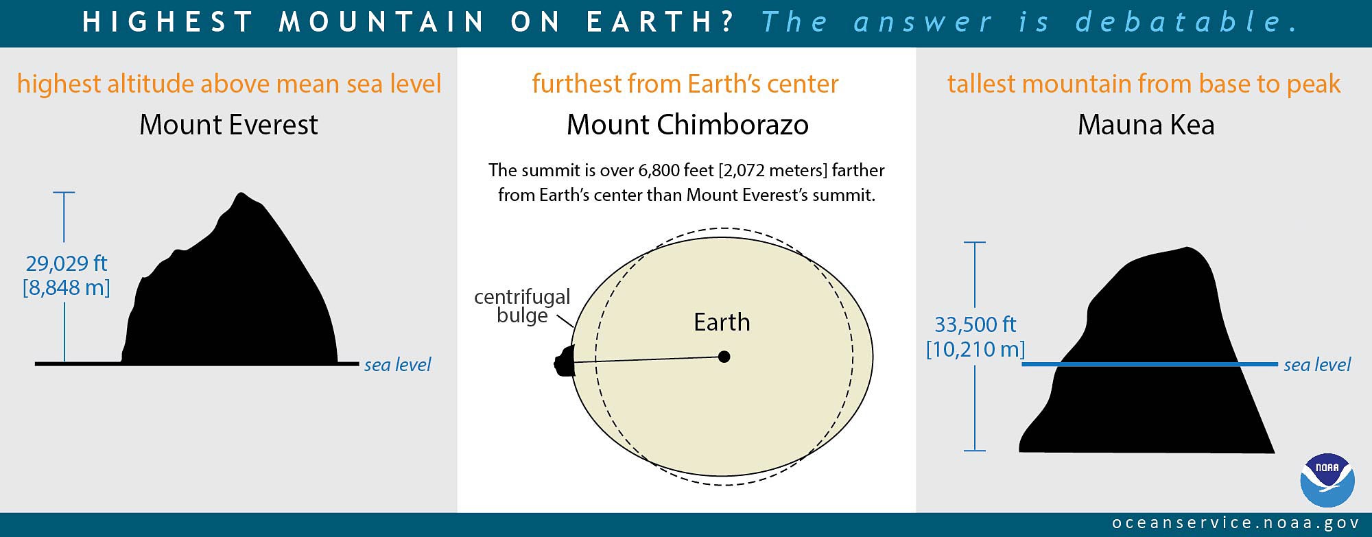
Less surprising is the fact that the deepest point on the planet is in an underwater trench.
The Mariana Trench is a 1,500-mile long canyon, located in the Pacific Ocean east of the Philippines.
According to NOAA, it is 35,900 feet deep at its deepest point called Challenger Deep.
That’s nearly 7 miles.
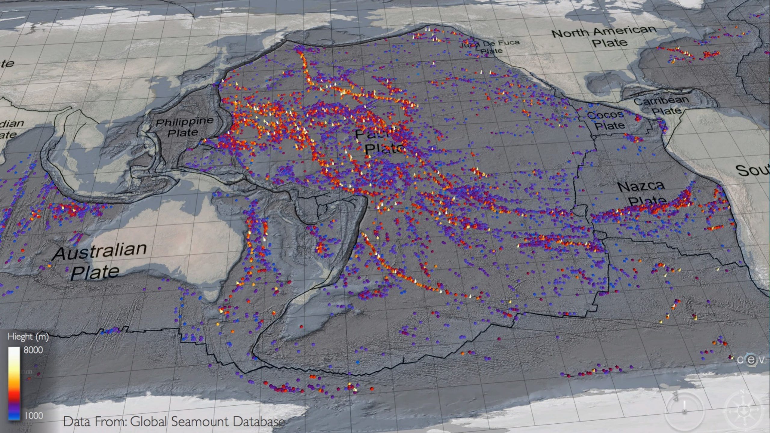
The longest mountain range on Earth is also underwater.
The longest mountain range on Earth is also underwater.
The mid-ocean ridge system spans more than 40,000 miles across the globe, according to NOAA.
In between mountains and trenches, are seamounts, abyssal plains and hills, which lead to continental shelves – the shallowest parts of the ocean.
In between mountains and trenches, are seamounts, abyssal plains and hills, which lead to continental shelves – the shallowest parts of the ocean.


What we don’t know
Alberto Neves, the hydrographic science program coordinator at the University of Southern Mississippi, said most of the ocean floor is unmapped.
"Well, there is an estimation that only 20% of the bottom of the oceans are surveyed, which means that we don't know about 80% of what's in there," Neves said.
Neves said there are various measurements of the ocean floor out there, but they don’t provide a complete picture of the bottom of the ocean.
"In general, when you look at the Google Maps and you see those beautiful features -- but in fact, some of them are estimated to exist or others we don't know."
Closing the map gap
Neves said there is an international project to remedy that problem called Seabed 2030.
Launched in 2017, the goal is to have 100% of the ocean floor mapped within the decade.
"It (has had) a lot of impact already," Neves said. "About four years ago, we had only 6% of the bottom of the ocean surveyed, and we are getting closer to 20% thanks to this international effort."
Some of the 20% that is mapped has some striking detail.
"It (has had) a lot of impact already," Neves said. "About four years ago, we had only 6% of the bottom of the ocean surveyed, and we are getting closer to 20% thanks to this international effort."
Some of the 20% that is mapped has some striking detail.
Rice said he is part of the team working on the National Bathymetric Source project, which aims to collect the best-available data to create high-resolution nautical charts.
"Where you have contours, are generally what you call them on topographic maps, we call them depth curves, I think traditionally on a chart," Rice said.
"Where you have contours, are generally what you call them on topographic maps, we call them depth curves, I think traditionally on a chart," Rice said.
"Then we tend to put a lot of soundings in there because, you know, that helps call out specific features."
Rice said the higher the resolution of a map, the better it can help not only vessels navigate the water but also policy makers better manage the resources that are there.
Links :
Rice said the higher the resolution of a map, the better it can help not only vessels navigate the water but also policy makers better manage the resources that are there.
Links :
- NPR : A U.S. submarine struck an underwater mountain last month, the Navy says
- The Guardian : US nuclear-powered submarine hits submerged object in South China Sea
- BBC : South China Sea: US submarine collides with unknown object
- CNN : How did a $3 billion US Navy submarine hit an undersea mountain?
- USNI : Attack Submarine USS Connecticut Suffers Underwater Collision in South China Sea / Navy Not Sure What USS Connecticut Struck in the South China Sea, Beijing Accuses U.S. of Cover-Up / Investigation Concludes USS Connecticut Grounded on Uncharted Seamount in South China Sea
- SCMP : South China Sea: experts still in dark over what smashed into US submarine / US nuclear submarine hit underwater mountain, not another ship, in South China Sea last month / US nuclear sub ‘may have hit an oil rig’ in South China Sea / China demands answers on US nuclear submarine accident in South China Sea
- Inf.news : What unidentified object did the USS Connecticut nuclear-powered submarine hit in the South China Sea?
- Business Insider : Here's how a $3 billion US attack submarine can run into an underwater mountain, according to a former submariner / The US Navy fired the leaders of the attack / China's state media accuses the US of lying about what happened to submarine it says hit an underwater mound in the South China Seasubmarine that ran into an underwater mountain in the South China Sea
- NavyTimes : Here’s the damage the submarine Connecticut sustained when it hit an undersea mountain
- 1945 : The Story Of How A Navy Submarine Hit An ‘Underwater Mountain’
- GeoGarage blog : An ambitious project aims to map the entire ocean floor. It could also open it up to mining
No comments:
Post a Comment