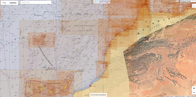
Chart 7713 (INT 1983) SHOM of the Agadir approaches in the GeoGarage platform
From Le7TV
A historic page is being written for the Kingdom of Morocco in the strategic field of marine cartography.
On Thursday April 10 in Rabat, an emblematic partnership agreement was signed between Morocco and France, officially transferring responsibility for the production and distribution of nautical charts of Moroccan waters to the Royal Navy.
This transition confirms the Kingdom's full control of one of the most technical levers of its maritime sovereignty.
The fruit of an exemplary cooperation initiated in 2008 with the French Navy's Hydrographic and Oceanographic Service (Shom), this handover testifies to the level of excellence achieved by the Hydrography, Oceanography and Cartography Division (DHOC), attached to the Royal Navy.
This is a major accomplishment that confirms Moroccan expertise in a highly strategic field previously reserved for a few maritime powers.
The signing ceremony, presided over by the Minister Delegate in charge of National Defense Administration, Abdellatif Loudiyi, and the French Ambassador to Rabat, Christophe Lecourtier, marks the culmination of an exceptional dynamic of technical, educational and scientific cooperation.
The signing ceremony, presided over by the Minister Delegate in charge of National Defense Administration, Abdellatif Loudiyi, and the French Ambassador to Rabat, Christophe Lecourtier, marks the culmination of an exceptional dynamic of technical, educational and scientific cooperation.
Morocco has officially taken over responsibility for producing and distributing marine charts of its territorial waters from France.
The Kingdom, now autonomous in the mapping of its territorial waters, is asserting its authority over its maritime areas and reinforcing its stature as a key player in naval security in the Atlantic and Mediterranean.
Raster charts from SHOM for the Coast of Morocco in the GeoGarage platform
A rise in scientific and strategic power:
From 2008 to 2024, Morocco patiently and methodically laid the foundations for its cartographic sovereignty.
From 2008 to 2024, Morocco patiently and methodically laid the foundations for its cartographic sovereignty.
Moroccan hydrographers were trained in Brest by the Shom, know-how was transferred and close cooperation led to the co-publication of 35 charts (18 electronic and 17 paper).
These charts, ranging from Sidi Al Hachmi in Mohammedia to the port of Tangier Ville, mark out an exemplary path of skill development.
Overview of the enc availablility from SHOM for the coast of Morocco
The launch of the Moroccan hydrographic and oceanographic vessel Dar El Beida in 2018, built in France by the Piriou shipyard in Concarneau, was a decisive milestone.
This flagship of the Royal Navy, equipped with cutting-edge technology, embodies Morocco's determination to explore, control and secure its maritime spaces with rigor and modernity.
FR377020, the first ENC co-produced by SHOM and DHOC (Division hydrographie, océanographie et cartographie de la marine royale marocaine) has been in service since December 19, 2011.
This co-production was implemented within the framework of the State-to-state administrative arrangement signed between Morocco and France in 2008.
This arrangement provides for a gradual transfer of France's hydrographic services responsibilities within the meaning of the Safety of Life at Sea Convention (SOLAS)2 .
It covers four main areas: maritime safety information, hydrographic surveys, marine cartography and training.
The initial aim of this arrangement is to train Moroccan personnel in hydrography and cartography, through a phase of co-production of charts between SHOM and DHOC, with the ultimate aim of enabling Morocco to produce, distribute and maintain its own charts.
With this in mind, in December 2009 SHOM and DHOC jointly signed the decisions to commission the first two paper charts produced by Moroccan cartographers, with SHOM's support.
The co-production of this first electronic navigation chart in December 2011 marks a further step in the implementation of this state-to-state administrative arrangement.
This ENC covers the Moroccan coast from Mohammedia to north of Kenitra at a scale of 1:150,000.
It is based on the INT 1973 international chart co-produced by Morocco and France.
Assuming sovereignty, consolidating partnership:
By assuming full responsibility for the production and distribution of its nautical charts, the Kingdom of Morocco is once again demonstrating its ability to combine sovereignty and cooperation.
By assuming full responsibility for the production and distribution of its nautical charts, the Kingdom of Morocco is once again demonstrating its ability to combine sovereignty and cooperation.
Far from representing a rupture, the agreement signed paves the way for renewed collaboration between Morocco and France on common maritime issues, such as navigation safety, the preservation of marine resources and the fight against cross-border threats
This agreement is a striking illustration of the Kingdom's strategic vision, under the enlightened leadership of His Majesty King Mohammed VI, which places marine sciences and sustainable development at the heart of national priorities.
It also testifies to the scientific, technological and institutional rise of Morocco, now recognized as a benchmark player in hydrography and oceanography in the African Atlantic area.
By asserting control over its waters, Morocco is strengthening its authority, protecting its maritime interests and paving the way for an inclusive, sustainable and fully sovereign blue economy.


No comments:
Post a Comment