Saturday, February 2, 2019

Watch this SpaceX ship come tantalizingly close to catching rocket parts

One of Mr. Steven’s final West Coast fairing recovery tests before shipping out for the East Coast. Wait for it…
courtesy SpaceX

From DigitalTrends by Trevor Mogg

When you really think about it, isn’t it mind-blowing that SpaceX can land a rocket back on the ground after a mission? Upright.
The private space company, led by billionaire entrepreneur Elon Musk, has pretty much perfected the landing procedure of its first-stage booster for its reusable rocket system. But it’s having a much harder time nailing the process for recovering the fairing, and has yet to pull it off.
It is, however, getting tantalizingly close, as this week’s effort shows …
The fairing is the nose cone that protects the payload during launch, and SpaceX has built a ship called Mr. Steven for catching it.
Yes, we said “catch.” You see, Mr.
Steven is basically a ship with a massive net over the top of it, and its job is to sail into position to save one of the two fairing parts from landing in the sea.
To be clear, the cone comes down in two sections, with the team currently focusing on perfecting the catching process for one part while fishing the other half out of the sea.
Once it has perfected the system, SpaceX is expected to invest in a second ship.
The impact and briny ocean water can damage the fairing, and seeing as it costs around $6 million to make one from scratch, SpaceX is understandably keen to use it more than once.


Mr. Steven, which is 62 meters long and 10 meters wide, has yet to catch the fairing despite several trial runs and three attempts during actual SpaceX missions.
To improve its chances of catching the fairing, the team last year increased the size of Mr.
Steven’s net by around four times, so it now it covers an area of about 3,700 square meters.
The fairing as a whole is around 13 meters tall and 5 meters wide, and tips the scales at a hefty 1,000 kilograms.
SpaceX has equipped each of the two sections with cold nitrogen thrusters to help them stabilize during their descent.
The system then deploys a GPS-equipped, steerable parafoil (something like a parachute) at around 5 miles above sea level.
This slows it down enough for Mr. Steven to get into position, but the final seconds of the operation are proving tricky.
As you can see from the video above, the latest test out in the Pacific this week came very close to working out.
The fairing even touches the edge of the net before sliding away and falling into the sea.
But considering that its very first effort missed by a distance of several hundred meters, the team is clearly making good progress.

Links :

Friday, February 1, 2019

Major expedition targets Thwaites Glacier


 Antarctica's Thwaites Glacier with the GeoGarage platform (NGA chart)

From BBC by Jonathan Amos

The US icebreaker Nathaniel B Palmer leaves Punta Arenas in Chile on Tuesday to begin an expedition to Antarctica's Thwaites Glacier.

The huge ice stream in West Antarctica is currently melting, and scientists want to understand its likely future contribution to sea-level rise.
If all of Thwaites' frozen bulk were to give way, it would add 80cm to the height of the world's oceans.


"How much, how fast? That's our mantra," said Dr Robert Larter.
"These are the questions we're asking about Thwaites," the British Antarctic Survey scientist told BBC News before leaving Chile.
Dr Larter will be directing operations on the Palmer when it gets on site.

Thwaites Glacier

Credits: NASA/OIB/Jeremy Harbeck

What is the purpose of the expedition?

The Palmer's 52-day cruise is just one part of a five-year, joint US-UK research programme to investigate the glacier.
Data is to be gathered in front of, and on top of the ice stream. Instruments will even be sent under its floating front, or shelf.
It's hoped that by capturing Thwaites' every behaviour, computer modellers can then better predict how its mass will respond to a warming world.


US icebreaker Nathaniel B Palmer

What sort of experiments are planned?

One of the studies to be conducted off the Palmer is a seal-tagging exercise.
Marine mammals will be captured on islands near the glacier and fitted with sensors.
When seals are released to dive in the vicinity of Thwaites, they'll report back on seawater conditions.
"Weddell and Elephant seals like hanging out near the ice front or under ice shelves, places we as humans can't go," explained Dr Lars Boehme from St Andrews University.
"The sensors record details about the seals' immediate physical environment, which gives us a clearer picture of the current oceanic conditions in these remote and inaccessible places."


The tags gather valuable data before falling off when the seal moults
L. Boehme / St Andrews University

Why is there such interest in Thwaites?

Thwaites, which is comparable in size to Britain, is what's termed a marine-terminating glacier. Snows fall inland and these compact into ice that then flows out to sea.
When in balance the quantity of snow at the glacier's head matches the ice lost to the ocean at its front through the calving of icebergs.
But Thwaites is out of balance.
It has speeded up and is currently flowing at over 4km per year. It is also thinning at a rate of almost 40cm a year.
Satellite data suggests Thwaites alone accounts for around 4% of global sea-level rise - an amount that has doubled since the mid-1990s.

What is 'marine ice sheet instability'?

It appears warm water from the deep ocean is getting under Thwaites' ice shelf and eroding the grounding - the point at which the ice stream becomes buoyant.

The problem for the glacier is its geometry.
A large portion of it sits below sea level, with the rock bed sloping back towards the continent.


This produces what scientists refer to as "marine ice sheet instability" - an inherently unstable architecture, which, once knocked, can go into an irreversible decline.

Some scientists have argued that Thwaites is already in this state.

The joint US-UK programme aims to test all assumptions.
"We have fantastic measurements over the past 25 years from satellites and from research vessels that have visited the region, but we need to extend this record to centennial timescales," explained Dr Kelly Hogan.
"I think a lot of people think what we are seeing anthropogenic (human-driven) change, but we don't yet have all of the links in the chain to say that definitively."


Sediment cores will reveal the past history of Thwaites Glacier

Dr Hogan will be taking sediment cores in front of Thwaites.
The fossil contents and chemistry of these muds can be used to deduce the past position of the glacier and the ocean conditions it was encountering - perhaps as far back as a few thousand years ago.
US collaborator Dr Rebecca Totten Minzoni, from the University of Alabama, said: "By discovering the history of Thwaites Glacier under past climate and ocean conditions, we can assess the stability of the glacier today.
"With the majority of the global population living at the coast, including important cultural and industrial centres like my hometown of New Orleans, we need to know how much this vulnerable region of Antarctica will contribute to sea-level rise over the coming decades."

Links :

Thursday, January 31, 2019

The tale of the albatross and the algorithm


From GlobalFishingWatch by Sarah Bladen

The first-ever satellite mapping of fishing vessel behaviours has identified that very few vessels are using one of the key techniques to avoid accidentally killing albatrosses.
Researchers hope a new analytics tool demonstrates that satellite data can help monitor efforts to reduce seabird mortality in fishing operations, and drive more transparency in general in the global fishing industry.

This is a story about the albatross, one of the most iconic and endangered groups of birds, about industrial fishing in the remotest ocean regions that kills them, and an astonishing experiment in machine learning which may just help to save them.
The remarkable project outlined here could also usher in true transparency to a global industry which is increasingly regulated but still too poorly policed.

Stephanie Winnard is a person on a mission.
Simply put, that mission is to end the accidental killing of tens of thousands of albatrosses every year in the fishing industry.
Winnard knows all about the albatross.
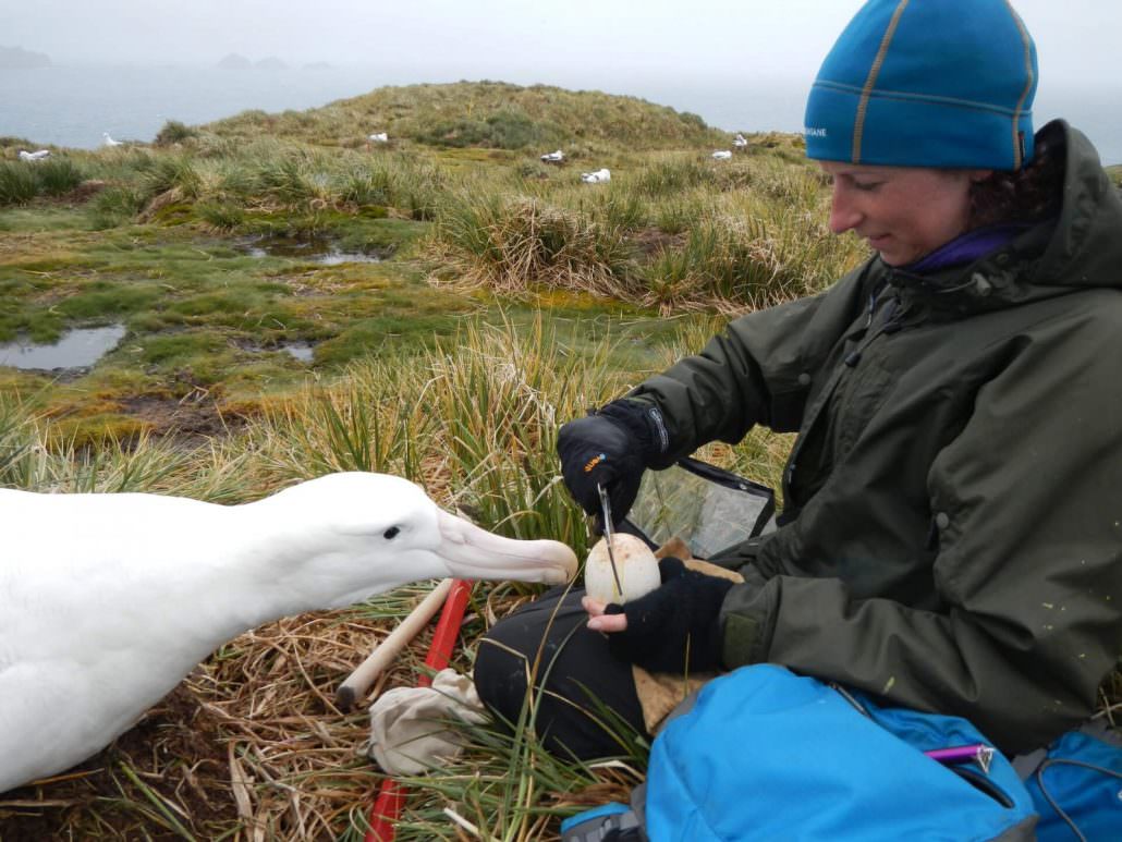
After completing a degree in biology, and earning her bird-tagging licence (yes, there is such a thing) she spent three chilly years in the sub-Antarctic studying these extraordinary birds, measuring their eggs, tagging their legs, observing their every move.

Stephanie Winnard, Birdlife International

For the past two and a half years, Winnard has been part of the Albatross Task Force, a specialist unit set up in 2006 by the RSPB and Birdlife International.
The Taskforce is dedicated to reducing the accidental killings of albatross that occur each year because of modern industrial fishing methods, and which are threatening to drive almost three quarters of all albatross species to extinction.
“Life is tough for seabirds, and especially for the albatross.” Winnard says.
“Not only do they live in an extremely harsh environment, and are slow to breed, but they also face numerous human threats to their survival: most notably from fishing.
Albatrosses, along with other seabirds such as petrels, feed during daylight hours and are irresistibly attracted to the trailing, baited fishing lines.” says Winnard.
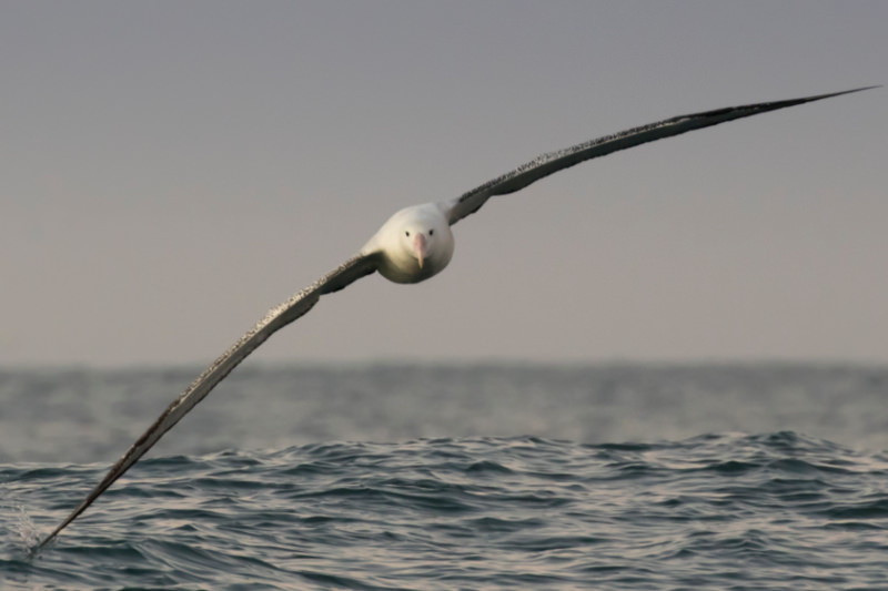
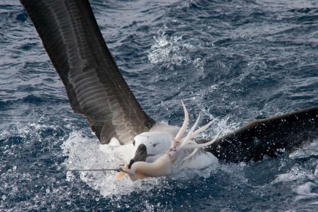
Seabirds scavenging on bait, like this juvenile black-browed albatross, often become hooked on longlines and subsequently drown.
©Dimas Gianuca (Albatross Task ForceBrazil)

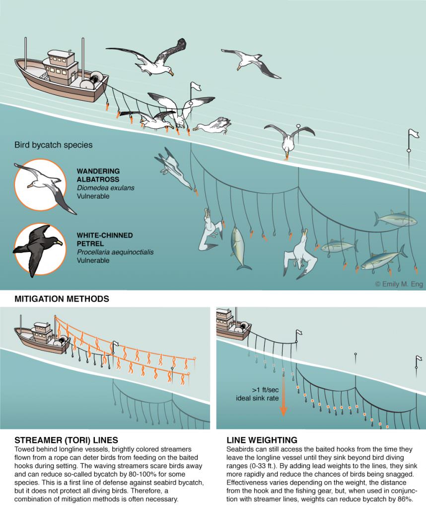
The main problem is due to longlining, a pervasive fishing method used to catch tuna and other ocean-going or pelagic species around the world.
Longlines are exactly what their name suggests – fishing lines, sometimes up to 80 miles long (that is the length of three marathons), strung with up to three thousand baited hooks and ‘set’ behind fishing vessels.

Of all the ways in which animals are killed unintentionally by man’s activities, few seem more senseless than the drowning of huge seabirds that are ensnared on fishing hooks targeting entirely different species.
Sadly, the same fate befalls turtles, sharks and other marine creatures.
The official term used for this accidental, collateral damage to marine life caused by fishing is ‘bycatch’, one of those words which strongly sanitizes a deeply troubling problem.

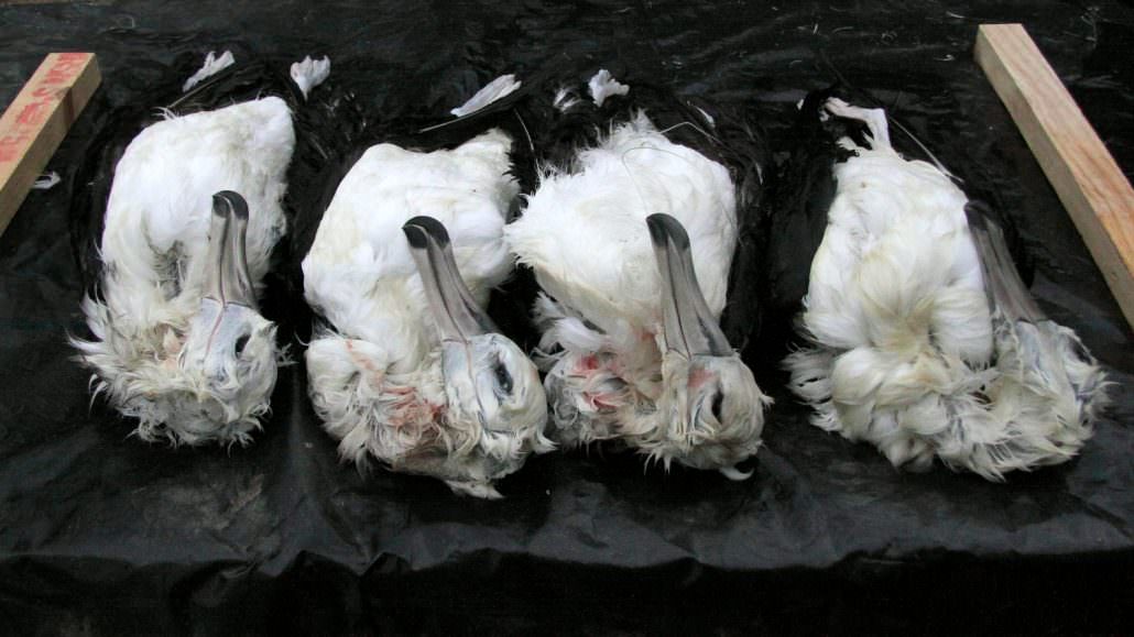
Victims of bycatch, these four albatrosses were hooked on longlines off the Namibian coast.
Every year, over 100,000 albatrosses die this way in fisheries across the world.
© John Paterson (Albatross Task Force Namibia)
“Birds flock to the boats in search of a free meal – but it can often be their last.” Winnard says.
“It’s estimated that around 100,000 albatrosses are killed every year by longline and trawl fisheries around the world, where they are hooked and drowned, or struck by trawler cables and dragged under the water.
This level of “bycatch” in the fishing industry is hugely unsustainable for birds that can take up to 10 years to start breeding.”
Fishing is the main threat to albatross, but it is not the only man-made peril they face.
The image of the albatross chick killed by a plastic toothpick in its gullet in the most recent BBC Blue Planet series was powerful proof of the impact of plastic pollution on marine life.
The photos Winnard has of row on row of drowned, waterlogged albatross, petrel and other seabirds laid out on vessel decks are also hard to forget.

The Task Force works directly with fishers and fishery managers worldwide on practical solutions to reduce the number of seabirds being killed by longliners and trawlers.
As a result, many countries, and five of the Regional Fisheries Management Organisations (RFMOs) responsible for regulating highly-migratory tuna fisheries, have now adopted measures that require the use of so-called ‘mitigation measures’ to reduce bird mortality.

Longline fishing vessels operating in many of the high-seas areas (that’s areas beyond national waters, more than 200 nautical miles from shore) where albatross are widely found now have to use at least two of three mitigation measures when they are setting their lines.
They can use weights to make their lines sink quickly below the surface, so the birds can’t reach the bait, they can attach bird-scaring or Tori lines strung with bright streamers to frighten the birds off, or they can adopt night setting – where lines are only put out for fishing between dusk and dawn when birds are less active.


As albatrosses only feed during the day, setting lines at night is an effective way to ensure that they don’t get hooked and killed.

Monitoring use of these mitigation measures presents a challenge.
Longline vessels can be at sea for up to 18 months at a time, few boats have on board observers to monitor fishing activity, which decreases how much influence governments are able to have on these fleets.

As any conservationist will point out, making rules is only the first part of effective action – authorities also need the capacity to carry out monitoring for compliance.
When activities are happening in some of the most remote corners of the globe, how can governments do this?

Currently, where vessels lack on board observers to report fishing behaviour, self-reporting is currently all that anyone has to go on.
Countries whose fleets are required to use these measures report widely differing levels of night-setting (between 29% and 85%) but it has long been suspected that many vessels are not doing as they say.
How do authorities know if this is actually happening? This is the challenge that drove Stephanie Winnard to enter the world of machine learning and algorithms at Global Fishing Watch (GFW).

GFW’s lead researcher David Kroodsma has been working for 3 years now refining methods to track the activities of fishing vessels using the vessel positioning data, transmitted via on-board Automated Information System (AIS) transponders and picked up via satellites.
Up until now, work has focussed on analysing the data captured to map the extent of global fishing geographically and temporally (for example when fishing moratoria are / are not in place).

All of which is ground-breaking in its way – but what the RSPB and Birdlife wanted was a whole new level of granularity.
Could GFW ‘train’ its computers to recognise the exact manoeuvres a vessel undertakes while it is setting, and hauling, a longline – in order to see if setting was really happening at night?
“This was a new challenge.” Kroodsma says.
“We did something pretty unprecedented, we trained machines to see if they could tell detailed vessel behaviour.
Turns out, they can.
Until now we could really only tell if vessel was fishing or not fishing, we could not go a level deeper and determine when they set a line, when they haul it in…now we can..” He adds that these same techniques can perhaps in future even identify the species vessels are targeting.
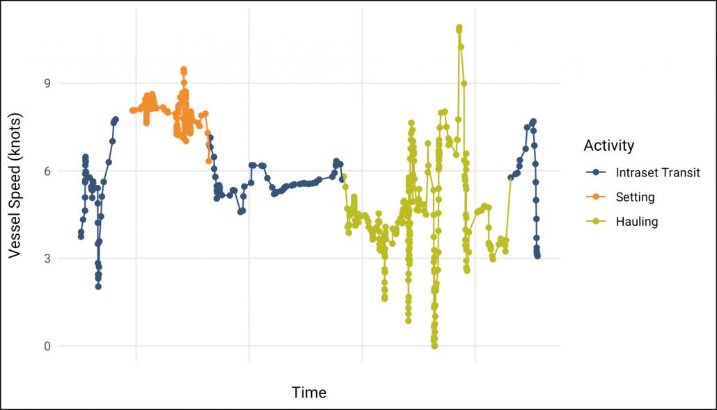
Example of the speed plot for the vessel track.
Here we can see that the set is pretty fast and pretty consistent in speed.
The intermediate period is pretty fast as the vessel returns to the start of the set, however it’s a bit slower, likely because the slightly slower speed is more fuel efficient, and then the haul is slower andpretty variable.
We used this type of information to label more data and develop a model to predict sets.
©Global Fishing Watch / Nate Miller

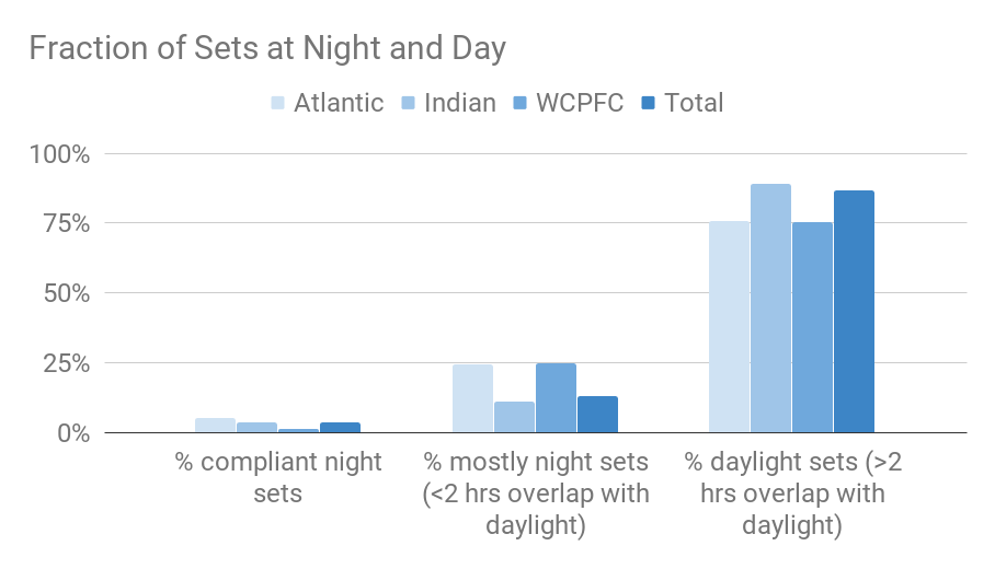
The GFW team used data for 2017, received from more than 60 orbiting satellites, corresponding to more than 300 pelagic longline vessels operating in the southern Atlantic, Indian and Pacific Oceans (south of 25/30degs of latitude depending on area concerned) to train a model of longline setting.
These are some of the remotest fishing grounds on Earth.

Studies have shown that bird bycatch rates suddenly increase one hour before sunrise, at nautical dawn, when birds start feeding, indicating that for night setting to be effective, the entire set must start after nautical dusk and end before nautical dawn.
Indeed, this is the best practice as laid out by the Agreement on the Conservation of Albatrosses and Petrels (ACAP).

With this in mind, the start and end of sets, as predicted by GFW neural net algorithms, were then compared to the timing of nautical dawn and dusk at the vessel’s location to determine compliance with night setting.

More than 15,000 vessel sets were analysed in the refined data set.
What the GFW team discovered was startling, and concerning.

Actual use of correct night setting (completely within the hours of dusk and dawn) was very low.
85% of sets were conducted with more than a two hour overlap with daylight, meaning only 15% of vessels (or potentially even fewer) set their lines fully at night.
This is a very low level of compliance, considering some countries have self-reported using 85% night sets.

Even more worryingly, the data shows that most vessels that set overlapping with day light are overlapping with nautical dawn rather than nautical dusk, at precisely the time that seabird feeding activity is high.

“What this has shown, very disappointingly, is that very few vessels have changed their fishing operations to night setting.
But the aim of this research is not to point fingers at this stage.” Winnard stresses.
“ We are sharing the results with the countries whose vessels were studied.
What we hope is that countries will recognise the potential of this technology as a very cost-effective tool to help them with sustainable monitoring, and drive good practice.”

“The most important take-home from this is that our results show it is possible to use independent compliance data to assess night setting to within two hours of accuracy.”
Kroodsma says “In future, technology like this could be used to inform countries and RFMOs of night setting implementation on a far larger scale than currently possible through just using traditional observers.”

There are also potentially even more far-reaching applications of this new granular level of analysis.
Fishing fleets use a wide-range of techniques and fishing gear to harvest their catch, all subject to different types of regulation in different fisheries to reduce their impact on non-target species.
GFW’s new know-how might mean for instance that compliance with requirements to reduce other bycatch such as endangered sharks can be much more closely scrutinised.

Kroodsma is hopeful.
“Bit by bit, as we work with partners, we are cracking open the previously opaque world of global fisheries and their impact on ocean biodiversity.
It makes clear that technology together with transparency will achieve effective management of the global fishing fleet.”

Finally, back to the extraordinary albatross.
It is somehow pleasing that a species famed for its long gliding flights (10,000 miles without a wing-flap in a single GPS-tracked journey) may now be helped using satellites sailing Earth’s orbit.
Exciting too that this technology, with the right data modelling, could also aid the preservation of other threatened marine life.
That would be a fitting 21st Century riposte to the great bird’s grievous fate in that famous poem.

Links :

    Wednesday, January 30, 2019

    French sailor, 73, wins round-the-world solo-race without modern instruments


    alias VHD spent 212 days alone at sea
    Golden Globe race involves navigation with sextants and paper maps

    From The Guardian by AP

    A 73-year-old French sailor has won an unusual, around-the-world yacht race after 212 days alone at sea without modern instruments, in what was his first sailing victory.

    Jean-Luc Van Den Heede arrived on Tuesday in Les Sables d’Olonne in western France in his 35-foot yacht Matmut, the first boat to finish the 30,000-mile Golden Globe race.
    Of the 19 sailors who started out last July, only five were still in the race on Tuesday.


    Congratulations Jean-Luc on being first across the finish line after 212 days at sea.
    Also, at 73 he becomes the oldest person to complete a solo RTW race.
    Respect!

    Van Den Heede was making his sixth circumnavigation of the globe.
    He hit trouble in November, when his mast was damaged during a storm in the Southern Ocean. Heading for land for repairs would have disqualified him from the race, so he attended to the damage himself at sea before rounding Cape Horn shortly afterwards.
    Jean-Luc van den Heede approaching the Golden Globe race’s finish line on Tuesday.
    Photograph: Sébastien Salom-Gomis/AFP/Getty Images

    Among those greeting Van Den Heede on Tuesday was British sailor Robin Knox-Johnston, who won the only other Golden Globe race 50 years ago.

    Jean-Luc Van Den Heede (left), is congratulated by Robin Knox-Johnston,
    after winning the Golden Globe race.
    Photograph: Sébastien Salom-Gomis/AFP/Getty Images

    The race involves solo sailors navigating with a sextant and paper maps, and communicating only occasionally with the outside world via short-wave radio.

    Links :

    Tuesday, January 29, 2019

    One year into the mission, autonomous ocean robots set a record in survey of Antarctic ice shelf

    A Seaglider, with the Getz Ice Shelf in the background, being prepared for deployment in January 2018 under the neighboring Dotson Ice Shelf.
    Credit: Jason Gobat/University of Washington

    From Phys by Hanah Hickey

    A team of ocean robots deployed in January 2018 have, over the past year, been the first self-guided ocean robots to successfully travel under an ice sheet and return to report long-term observations.

    Beyond mere survival, the robotic mission—a partnership between the University of Washington's College of the Environment, the UW Applied Physics Laboratory, the Lamont-Doherty Earth Observatory of Columbia University, the Korean Polar Research Institute and Paul G. Allen Family Foundation—has ventured 18 times under the ice shelf, repeatedly reaching more than 40 kilometers (25 miles) into the cavity, among the farthest trips yet into this treacherous environment.

    "This is the first time any of the modern, long-endurance platforms have made sustained measurements under an ice shelf," said Craig Lee, a UW professor of oceanography and member of the Applied Physics Laboratory.
    "We made extensive measurements inside the cavity.
    Gliders were able to navigate at will to survey the cavity interior, while floats rode ocean currents to access the cavity interior.

    "It's a major step forward," Lee added.
    "This is the first time we've been able to maintain a persistent presence over the span of an entire year."

    The project funded by Paul G. Allen Family Foundation seeks to demonstrate the technology and gather more data from the underside of ice shelves that are buttressing the much larger ice sheets.
    Direct observations of how warmer seawater interacts with the underside of ice shelves would improve models of ice sheet dynamics in Antarctica and Greenland, which hold the biggest unknowns for global sea level rise

    The instruments’ travel routes over the past year.
    Pink, orange and yellow tracks show the three self-navigating Seagliders.
    Teal tracks show the drifting floats.
    The background is a satellite image of Dotson Ice Shelf captured Feb. 28.
    Credit: Luc Rainville/University of Washington"

    Some ice sheets terminate in large ice shelves that float out over the ocean, and those act as a buttress," Lee said.
    "If the ice shelves collapse or weaken, due to oceanic melting, for example, the ice sheets behind them may accelerate toward the sea, increasing the rate of sea level rise."

    "Most of the uncertainty in global sea level rise predictions for decades to centuries is from ice sheets, which could contribute from 1 foot to as much as 6 feet by 2100," said Pierre Dutrieux, a research professor of oceanography at the Lamont-Doherty Earth Observatory.
    "A key driver is interaction with the ocean heat and these new tools open tantalizing perspectives to improve on current understanding."

    The mission set out in late 2017 to test a new approach for gathering data under an ice shelf, and on Jan. 24, 2018, devices were dropped from the Korean icebreaker R/V Araon.
    This week, two self-navigating Seagliders reached the milestone of one year of continuous operation around and under the ice shelf.

    Robot submarines operated by the British Antarctic Survey, known as Autosub3 and Boaty McBoatface, successfully completed 24- to 48-hour voyages in 2009, 2014 and 2018.
    These missions surveyed similar distances into the cavity but sampled over shorter periods due to the need for a ship support.

    This sketch shows how three self-driving Seagliders and four drifting floats tracked conditions below an Antarctic ice shelf.
    Inside these caves, warmer saltwater flows in on the bottom, carrying heat which may eat away at the ice, and fresher glacial meltwater flows out above.
    Credit: University of Washington

    By contrast, the U.S.-based team's technology features smaller, lighter devices that can operate on their own for more than a year without any ship support.
    The group's experimental technique first moored three acoustic beacons to the seafloor to allow navigation under the ice shelf.
    It then sent three Seagliders, swimming robots developed and built at the UW, to use preprogrammed navigation systems to travel under the ice shelf to collect data.

    The mission also deployed four UW-developed EM-APEX floating instruments that drift with the currents at preselected depths above the bottom, or below the top of the cavity, while periodically bobbing up and down to collect more data.
    All four of these drifting instruments successfully traveled deep under the ice shelf with the heavier, saltier water near the seafloor.
    Three were flushed out with fresh meltwater near the top of the ice cavity about six to eight weeks later.
    One float remained under for much longer, only to reappear Jan. 5.

    During the past year, the fleet of robots has reached several milestones:
    • A Seaglider reached a maximum distance of 50 kilometers (31 miles) from the edge beneath Dotson Ice Shelf in West Antarctica;
    • The Seagliders made a total of 18 trips into the cavity, with the longest trip totaling 140 kilometers (87 miles) of travel under the shelf;
    • The Seagliders also made 30 surveys along the face of the ice shelf;
    • After one year, two out of three Seagliders are reporting back;
    • In the current Southern Hemisphere summer, one of the Seagliders has gone back under the ice shelf and has completed two roughly 100-kilometer (62-mile) journeys;
    • Another Seaglider will begin its second year of sampling at the face of the ice shelf;
    • Three drifting floats journeyed under the Dotson Ice Shelf and back out in early 2018;
    • After 11 months under the ice, the fourth float reported home in mid-January 2019 close to the neighboring Crosson Ice Shelf.
    Researchers are now analyzing the data for future publication, to better understand how seawater interacts with the ice shelves and improve models of ice sheet behavior.

    A drifting robot known as an Electro-Magnetic Autonomous Profiling Explorer, or EM-APEX, is lowered into the ocean.
    This is one of four floats that traveled with currents under the Dotson Ice Shelf.
    Credit: Paul G. Allen Family Foundation


    Four months of data show three Seagliders dropped from the ship in late January, then traveling toward the Dotson Ice Shelf (white).
    Two Seagliders (pink and orange) venture under the ice sheet in summer, while a third (yellow) samples along the face.
    The gliders then spend the colder months sampling along the ice sheet’s edge.
    Meanwhile, the drifting floats are dropped closer to the ice edge in late February.
    The teal tracks show how they drift under the ice sheet and then get flushed out in late March.
    A fourth float drifted to the right of this image, reaching a neighboring ice sheet.
    Credit: University of Washington

    Links :

    Monday, January 28, 2019

    Under 30 satellite companies Spire and ICEYE team up to fight crime on the High Seas

    What would you do with actionable information about every square meter on Earth,
    updated every hour?
    source : ICEYE SAR satellite constellation

    From Forbes by Alex Knapp

    Finnish satellite startup ICEYE and San Francisco-based satellite startup Spire, both cofounded by alums of the Forbes 30 Under 30, announced Tuesday that they are embarking on a joint project to help government and NGO customers track possible sources of crimes on the high seas, ranging from illegal fishing to piracy.

    The product offered by the two companies focuses on the tracking of so-called "dark vessels"—ships on the ocean that aren't broadcasting a signal that can be tracked by the Automatic Identification System (AIS), which is used by governments and traffic control systems to monitor the real-time positions of ships at sea.
    Spire already offers a service for its customers to track ships by AIS signal, but increasingly heard requests from customers around dark vessels.
    "As use cases came out in discussions with customers and government, dark vessel detection became quite a popular request," Iain Goodridge, Spire's head of product marketing told Forbes.

     Iceye's X2 satellite captured four Chinese dark fishing boats near Argentinian sea areas.

    One reason for this is that ships will often turn off their AIS when they're about to engage in illegal activity.
    Those activities range from illegal fishing to dumping waste to smuggling goods to piracy.
    So being able to track a ship that wasn't broadcasting its AIS is of particular interest.

     SAR image of Dubaï (Iceye)

    ICEYE, in the meantime, has also been offering imaging services related to shipping.
    ICEYE's satellites use synthetic aperture radar (SAR) rather than cameras or spectroscopes.
    SAR is a type of radar capable of creating high resolution 2- and 3-dimensional images.
    It's particularly of interest for maritime applications because unlike other types of satellite imaging, SAR can be used to see through clouds and other weather to monitor the surface.

    Animation of the ICEYE/Spire product

    The capabilities of the two companies' satellites provided an ideal way to collaborate in order to track dark vessels, says ICEYE CSO and cofounder Pekka Laurila.
    "We knew what Spire was doing and we could see the complementarity over there and vice versa."

    Global Fishing Watch uses data broadcast from ships at sea to map more than 60,000 industrial-sized fishing vessels.
    In 2017, nano-satellite data from Spire increased resolution by nearly doubling the data in the platform.
    The two companies' collaboration will offer two basic services to detect dark vessels.
    In one service model, a customer would ask the two companies to monitor a particular area of the ocean at a given time.
    ICEYE would then use its satellites to locate all the ships in that area at that time, which can then be compared with Spire's detection of AIS signals.
    Any ship that ICEYE detects by radar that's not broadcasting an AIS signal could then be flagged for investigation.

    In the second service model, Spire would alert a customer when a vessel in an area they are interested in has turned off its AIS signal, while ICEYE would use its satellites to continue monitoring that ship so that authorities will know exactly where they should be investigating.

    How one service model works :
    ICEYE & Spire now deliver true detection of illegal and suspicious activities at seas (illegal fishing, smuggling, dumping etc).
    When Spire detects a vessel switching off its AIS, then Iceye makes a Radar picture of that location and its predicted locations - at seas, through clouds and in darkness 
    Anton Klusener or Forbes

    Spire and ICEYE won't be the first companies to offer monitoring or detecting dark vessels, but what the companies believe they bring to the table is a unique combination of capabilities that can be brought to bear more frequently than existing services.
    Spire has several dozen satellites in orbit, while ICEYE has recently added two more satellites to its constellation of SAR-imaging satellites.

    "Previously, dark vessels might have been detected every once in awhile but not tracked," explained Laurila.
    "Or because this detection would be relatively predictable with sparse satellite flights, you could act in between flights if you were smart.
    Now we're increasing potential for detection that can work as a deterrent.

    Links :

    Sunday, January 27, 2019

    2018: full, one year time lapse of surface winds over the North Atlantic

    This animation shows a full, one year time lapse animation of surface winds from Jan 1, 2018 until Jan 1, 2019, over the North Atlantic.
    The data come from the National Weather Service's GFS numerical weather model (https://www.emc.ncep.noaa.gov/index.p...).
    Blue colors represent slower winds.
    Greens and yellows are faster winds.
    Streamlines show the direction of the wind in each frame of the animation.
    This is one of the first 4K time lapse animations generated from earth.nullschool.net.
    The animation took 48 hours to render as 3,000 individual frames encoded to video.
    Notice how a few hurricanes appear in July but then August is quiet, only for things to really pick up in September.
    Also notice how fall and winter bring massive storm systems to the upper North Atlantic (Greenland, Iceland, Ireland, the UK, Norway).