Tuesday, August 11, 2026

How long can Iran weaponise Hormuz?

photograph: ap

From The Economist by 
 
Longer than the world hopes, according to our Hormuz dependency dashboard 

For years the world has feared that Iran has been pursuing nuclear arms.
Five months of war have taught the country’s rulers they were already in possession of a formidable weapon.
Geography and firepower give them de facto command of the Strait of Hormuz, through which a fifth of the world’s oil and liquid natural gas (lng) normally flows.
Choking that artery has given Iran’s leaders immense leverage over their adversaries.

Iran’s foes hope that Hormuz will prove to be a wasting asset.
Shutting Hormuz is “a card you can play once,” said Chris Wright, America’s energy secretary, in May.
 Gulf states are busily seeking alternative export routes.
Tom Barrack, Donald Trump’s envoy to Iraq and Syria, reckons the strait will be “an afterthought in two years”.

The Economist has interviewed experts and analysed data to build a “Hormuz dependency dashboard” to test these claims.
It points to three conclusions.
First, the staying power of the Iranian threat varies by commodity and country.
Second, Iran’s ability to cash in on the strait will diminish but may never vanish.
Third, even if the fees Iran can charge diminish over time, its strategic leverage will not necessarily fade in step.
Indeed, it may even deepen as the regime institutionalises its regional influence.

Start with how much Hormuz traffic could simply circumvent it.
Some 16m barrels of crude oil crossed the strait daily before the war.
That looks easiest to divert. Saudi Arabia’s east-west pipeline, which avoids the strait by crossing the peninsula to Yanbu on the Red Sea carried just 1m barrels a day (b/d) for export before the war.
Today it is running at its full 7m b/d capacity.
Nearly 5m b/d of that is exported; the rest feeds coastal refineries.
The United Arab Emirates (uae) has maxed out its Habshan-Fujairah pipeline, which carries 1.8m b/d, up from 1m b/d before the war.
Some 200,000 b/d flows through a smaller, once-idle Iraqi pipeline to Turkey.

 
chart: the economist

That narrows the crude-export deficit to 10m b/d. Now add new pipelines likely to be built as a result of the war.
Land acquisition poses no problems in the Gulf’s command-and-control economies, says a lawyer familiar with the subject.
The most advanced, in the uae, would run parallel to the existing line, adding 1.8m b/d by late 2027.

Iraq aims to raise the capacity of its pipeline to 1m b/d within a year.
It also plans a new one to connect its southern fields to existing routes to Jordan, Syria and Turkey.
Contracts for the 2.5m b/d project are being awarded and it should be done within four years, says Rahul Choudhary of Rystad Energy, a consultancy.
So by 2030 another 5m b/d of crude could bypass Hormuz.

But that still leaves the same amount with no alternative route.
And none of these fixes is foolproof.
Iraqi projects could be derailed by security risks and cross-border rows. Many dreamed-up pipelines never see the light of day.
Tankers leaving Yanbu for Asia usually sail via the Bab al-Mandab strait, where they are vulnerable to attacks by Iran-allied Houthi rebels.
Saudi crude could travel via the Suez canal or Egypt’s Sumed pipeline.
But even that route may not be safe: on July 29th a drone hit a tanker at Damietta, a port near Suez.

 
map: the economist

Iran—or its proxies—could attack any new infrastructure that it fears depletes Hormuz’s power. Barbara Leaf, who worked on Middle East policy in the Biden administration, reckons Iran would be less likely to hit such sites if the conflict ends in a negotiated settlement.
But the lingering risk of attacks could still push up insurance and financing costs for such projects.

Rerouting refined products is even harder.
Gulf countries shipped nearly 5m b/d of petrol, diesel and other fuels via Hormuz last year.
No overland pipeline alternatives exist for these.
Saudi Arabia has plans for one as part of a 2m-b/d expansion to its East-West corridor.
But that is still at an early stage and would need a similar increase in Yanbu’s capacity.
Iraq is sending 1,000 lorries of fuel oil to Syria a day, up from ten pre-war.
But that is slow and pricey.
Syria has earned $15m-20m in transit receipts from the traffic alone since the conflict began.
New refineries outside the Gulf would take even longer to build than pipelines and cost billions of dollars. 

 
chart: the economist

The problem is most acute for lng, exported almost exclusively by Qatar. No lng pipeline is under construction and no feasibility studies have been published. Qatar could in theory lay simpler gas pipes to Oman, but they would need to carry as much gas as Russia’s Nord Stream pipelines once delivered to Europe. More implausible still, Qatar’s entire liquefaction complex would need recreating on the Arabian Sea coast.

There is some room for hope. Most importers can, in time, wean themselves off Hormuz supplies. A few years of high prices could elicit an extra 2-3m b/d from the Americas and beyond. China’s refineries still hold ample spare capacity. lng is riding the fastest expansion in its history. So Iran’s leverage over global prices will weaken before the decade is out.

The same is not true of its hold over its Gulf neighbours—and not just because a sizeable share of their energy exports will still need Hormuz for years. Many also depend on the strait for imports. The Gulf Arab states rely on external suppliers for 95% of their grain but only Saudi Arabia has decent bulk-handling terminals, and these are not big enough to supply the whole region. Nor is moving lots of grain, iron ore or bauxite overland viable: a single Panamax vessel carries 60,000 tonnes of cereal, enough to fill 2,000 trucks.

 
chart: the economist

One obvious fix would be more regional railways but these would also be slow and costly to build.
Past mining-railway projects in Australia, built across similar desert terrain, have cost $12m-15m a kilometre. So a Red Sea-to-Qatar line could run to $25bn or more.

They have strategic grain stockpiles that typically cover four to six months of demand.
But there is no equivalent for containerised goods such as fresh food, medicines and appliances.
The region’s biggest container port, Jebel Ali, which has a capacity for nearly 20m 20-foot equivalent units (teu) a year, sits inside the Gulf.
Outside the strait, the largest is Jeddah which can hold 7.5m teu.
It was already running near full tilt before the war, says Alexis Ellender of Kpler, a data firm.

So our analysis suggests that Iran will be able to weaponise Hormuz for some time—and monetise it. Gulf states’ varying exposure may mean they diverge in what they will tolerate to get their ships moving.
Qatar has suggested that it could accept temporary fees; others have held a tougher line.
But now even the hawkish uae has softened: it is starting to trade with Iran again and their diplomats are talking.

Assuming it retains control of Hormuz, how much can Iran hope to make from it?
An Iranian mp claimed in June that the country was collecting $1.5m-2m per vessel transiting the strait.
That implies takings of more than $35bn a year, assuming traffic at about 70% of pre-war levels.
You cannot be serious

That figure is eye-popping—and implausible.
Rates set at gunpoint, in a market with nowhere else to go, will not survive a settlement allowing near-normal flows to resume.
Draft legislation submitted to Iran’s parliament in June envisages rates based on cargo volume, value and vessel type, with one constraint: the charge must stay below the cost of the next-best alternative.
Prices could also vary depending on the nationality of the owner or charterer.

Shahin Iraninejad of gssi, a sovereign-risk advisory, points out that another legislative proposal posits an average fee of €3 a tonne in Iranian waters and €2 in international waters.
He puts expected future income at a more modest $2-3bn a year.
As bypass capacity grows, that would drop—but not uniformly.
Crude tankers can hope for a bargain soon; oil-product, lng and bulk carriers may face higher fees for years.

Whether such revenue flows prove durable depends on shipping firms’ ability and willingness to pay.
As long as charges are predictable, easy to settle and below war-risk premiums, many probably will, says Richard Meade of Lloyd’s List, a shipping journal.
But that would change if vessels repeatedly manage to traverse the strait without paying Iran.
A tension emerges: Iran needs peace with America for its fee regime to function.
But it will need to keep up attacks on disobedient tankers to ensure the fees are paid—which could make peace hard to maintain.

On the brighter side, Iran might drop its fees faster than it needs to. Its strategic objective, says Mr Meade, appears to be maintaining market participation and reinforcing its role as gatekeeper, rather than maximising revenue.
More gloomily, it wants something more lasting: a governance system—whether a bilateral framework with Oman, a maritime-services architecture or a permit regime.
The ease with which Iran seized its new weapon shocked its foes. Its grip on Hormuz looks set to outlast the war.
 
Links : 

Monday, August 10, 2026

Divers recover a bottle of Guinness from a 162-year-old shipwreck

The site of the shipwreck of the Mindoro, which sunk in 1864. (Stefan Panis)

From WashingtonPost by Miriam Waldvogel

The team discovered the bottle with a seal that says “Guinness Extra Stout, London” while exploring a shipwreck in the English Channel

The dark glass bottle was one of dozens strewn around the sunken ship when the divers spotted it. Unlike many others, though, its seal was intact, and up on the surface, they could make out the words: “Guinness Extra Stout, London.”

The antique ale is thought to be 162 years old.

The team discovered the bottle while diving a shipwreck in the English Channel last year but waited to publicize the find more extensively while they conducted research, including contacting the company itself. They hope, with the help of a lab at KU Leuven, a university in Belgium, there’s a chance the historical draft could even be re-created.
“It is quite rare to find something with a seal on it,” said Stefan Panis, one of the divers. “We are very, very excited to see what the test will reveal.”

 
A bottle has a seal that reads "Guinness Extra Stout London." (Stefan Panis)
 
A bell found at the site indicates that the wreck is a ship called the Mindoro, which set sail for Vancouver from London on Nov. 20, 1864. A week later, navigating through a treacherous part of the English Channel, it collided with another ship and sank to the bottom of the ocean, where its contents sat in cold and dark conditions — ideal for preserving a bottle of beer, like the back of a fridge.

If the bottle managed to keep out the seawater, there is a chance the Guinness might still be sippable — the alcohol would have prevented things from growing inside, said Kevin Verstrepen, who runs a lab at KU Leuven that studies yeast and fermentation.
But the Guinness brewed at the time might not have been quite as palatable as modern brews.
“In the old days, brewers were not as good working sterilely. Probably, from a microbial point of view, it was a bit of a zoo there,” Verstrepen said, which means the beer could have sour or funky flavors.
Additionally, Guinness made in that period would not have been carbonated by nitrogen, which was introduced in the 1960s and gives the beer its smooth texture and creamy head.

The company has been based in Dublin since 1759. But there is also evidence that at least some Guinness was bottled in London in the mid-19th century.

Diageo, the British alcohol conglomerate that now owns Guinness, did not respond to a request for comment. The company previously told the Irish Times that it was evaluating the find.
There is probably more Guinness to be discovered in the wreck. While the one recovered bottle was found out in the open, the divers also found wooden crates packed with bottles and stored upside-down. They also plan to examine records that they think will contain the ship’s manifest.

The divers plan to go back in two weeks to recover four additional bottles, two for the Verstrepen lab and two for the company, Panis said.
It’s unlikely that the lab will be able directly recover original yeast, Verstrepen said, because beer yeast does not have a long lifespan after bottling. However, he thinks they can find traces of yeast DNA in the hopes of finding a close living relative to re-create the brew.

“With sequencing the DNA … we can see exactly where it is on this family tree, and then we can look for modern living siblings of that yeast,” he said.
As rare as the find is, one of Panis’s partners, Pawel Truszynski, had experience in unearthing antique alcohol before. Truszynski was part of another team that in 2024 discovered a 19th-century shipwreck in the Baltic Sea laden with 100 sealed bottles of champagne.
In 2014, a different group of researchers recovered a 200-year-old bottle of distilled spirit from a shipwreck off the coast of Poland.
And a small brewery in Sunderland, England, at one point sold a porter made with yeast cultured from old bottles found in a different shipwreck in the English Channel, that one from 1825.

Sunday, August 9, 2026

Surfin penguin

Saturday, August 8, 2026

Carlo Borlenghi

 “Navigo in mari inesplorati, ma c’รจ una bussola nel mio cuore che conosce la strada”.… 
 E. Dickinson
 
 Carlo Borlenghi has immortalized thirteen America's Cups, portraying, with his famous and iconic shots, the evolution of the event and the boats in over thirty years of career.
The power of the foils that slice through the water, the emotion in the eyes of the crew, the tension of a match race, they all become palpable in his photos that not only fix the moment, but transform it into art.


Links :

Friday, August 7, 2026

How whaling strengthens the bonds uniting nation-states and Indigenous peoples

Jerry Arey, Moses Kayotuk and Larry Arey atop a landed bowhead.
 
From Arctic Today by Barry Scott ZellenJuly 24, 2026

Remembering the Great Bowhead Hunt of 1991
 
For more than four decades, my work as an Arctic scholar has been animated by a single, foundational truth: the global arena is not merely a collection of Westphalian states competing for structural dominance.
While classical international relations theory fixates on oversimplified structures such as Kenneth Waltz’s classic “three images,” it leaves an analytical void at the foundational level of human organization.

To fill this gap, I have advanced 4th Image Theory.
This framework recognizes that beneath and before the modern state lies a deeper, older reality: the tribal, sub-state, and indigenous polities that have survived millennia of change.
These are not mere domestic minorities; they are enduring sovereign entities whose governance models, land claims, and cultural practices provide a platform for enduring regional stability.

Nowhere is the intersection of state sovereignty and indigenous self-determination more sharply defined — or more routinely misunderstood —than in the deep blue waters of our global commons.
For decades, the international community, led by urban activists far removed from the realities of life on and by the sea, has viewed the harvest of cetaceans through the singular lens of prohibition.
Whaling has been falsely cast as an archaic, ecologically destructive relic of a bygone era.

This view is profoundly flawed.
It ignores both the success of modern conservation and the deep, constitutional evolution of native land claims.


When we look past the emotive rhetoric of anti-whaling campaigns, a startling paradox emerges.
The sustainable management of whaling is not a point of permanent division.
Instead, it offers a powerful framework for bridging the gap between sovereign nation-states and Indigenous peoples, forging a shared, collaborative international order.

Alternative:

To understand how whaling can unite rather than divide, one need only look to the Western Arctic.
In 1982, Canada made the decision to withdraw from the International Whaling Commission (IWC).
This move was not an act of environmental defiance; it was a pragmatic recognition of domestic political realities.

At the time, Ottawa was deep in negotiations over comprehensive land claims agreements with Arctic Indigenous peoples —treaties that would ultimately reshape governance of the Northwest Territories and lead to the creation of Nunavut.

By stepping away from the rigid, often deadlocked dictates of the IWC, Ottawa cleared a path to restore the traditional Inuvialuit and Inuit bowhead whale hunting.
It replaced distant, centralized and neocolonial governance with an innovative domestic model based on co-management.

Through boards composed of both indigenous hunters and federal biologists, decisions on quotas, sustainability, and ecosystem monitoring were co-produced.
Traditional Ecological Knowledge (TEK) was elevated to equal standing with Western empirical science.

The foundational proving ground for this paradigm shift occurred on Sept.
3, 1991, in the waters off Shingle Point.
For over half a century, the Inuvialuit had been denied the right to hunt a bowhead whale (Arviq), a restriction born of global conservation anxieties that completely ignored the ecological balance maintained by the original inhabitants of the coast.


The 1991 hunt was one of many fruits of the historic 1984 Inuvialuit Final Agreement (IFA) — the first Canadian comprehensive land claim settlement north of 60.
This treaty did not merely grant land rights; it erected a revolutionary, constitutionally protected architecture for wildlife co-management.
When the Inuvialuit Game Council and the newly formed Fisheries Joint Management Committee approved a license for a single bowhead, they were putting the constitutional teeth of their land claim to the test.

The hunt itself became a masterclass in cross-generational, cross-cultural collaboration.
Because a full 54 years had passed since the last local bowhead harvest, the Inuvialuit faced a profound rupture in practical whaling knowledge.
To bridge this historical chasm, they looked across the border to their Inupiat kin in Alaska.

Experienced whaling captains from the North Slope traveled to the Mackenzie Delta, bringing with them modern safety protocols, traditional tracking techniques, and specialized harvesting equipment.
This included penthrite projectile bombs designed to ensure a humane, efficient kill.

On Sept. 4, a crew led by Inuvialuit whaling captain Danny A. Gordon successfully landed a 36-foot, 40-ton bowhead whale.
The event was a profound cultural awakening, but its political implications were even greater.

The processing of the whale on the beaches of Shingle Point required the mobilization of whole communities — Aklavik, Inuvik, Tuktoyaktuk —distributing muktuk (skin and blubber) across the region according to ancient laws of sharing that reinforce social cohesion.

For the Canadian state, this was a watershed moment in regulatory flexibility.
Federal fisheries officers worked alongside indigenous hunters — not as adversarial enforcers, but as technical partners.
The 1991 harvest proved to a skeptical international community that an indigenous polity, armed with modern legal authority and rooted in traditional ecological wisdom, could safely manage a protected species without state paternalism.
It transformed the concept of conservation from a top-down mandate into a collaborative, treaty-based partnership between indigenous peoples and the state.

This historical lesson demonstrates that when a nation-state respects the maritime traditions of its Indigenous peoples, it does not weaken its own sovereignty; it actually strengthens the fabric of its domestic peace.

The restoration of the bowhead hunt in the Western Arctic did not spark ecological collapse.
Instead, it revitalized community cohesion, strengthened food security in an economically marginalized region, and integrated indigenous governance directly into the structural machinery of the state.

In recent years, we have seen history repeating itself, with Tokyo’s decision to exit the IWC in 2019, following in Canada’s footsteps so that Japan, too, could resume coastal whaling within its own territorial waters and EEZ.

Japan’s pivot offers a compelling point of alignment with northern Indigenous communities.
Small, historic whaling towns of coastal Japan —such as Taiji, Wada, and Ayukawa — possess a deep maritime heritage that mirrors the subsistence culture of the Inuvialuit.
For coastal communities of both the Arctic and the Pacific, the whale isn’t merely a resource to be extracted; it is an economic anchor, a dietary staple, and the focus of deep cultural veneration.

When modern states like Japan, Iceland and Norway defend their right to utilize abundant marine resources sustainably under international law, they are fighting the exact same battle against eco-colonialism that Indigenous communities have waged for generations.

By reframing the whaling debate around the principles of sustainability, food security, and cultural survival, we create a powerful common denominator: sovereign nations defending their maritime rights and indigenous polities protecting their ancestral subsistence traditions find themselves standing on the same side of the geopolitical ledger.
They are united by a shared commitment to what I call constructive realism—a pragmatism that recognizes that real-world stability requires balancing ecological limits with human survival and cultural continuity.

The international community must stop viewing whaling as a binary conflict between conservationists and exploiters.
Instead, it must be recognized as a sophisticated arena for co-management, where the sovereign rights of coastal states and the inherent rights of First Nations converge.
By honoring Native traditions through robust, collaborative, and scientifically sound frameworks, we do not fracture global unity.
Instead, we ground it in the realities of our shared environment, proving that international relations are at their most resilient when they honor the tribal foundations upon which our world was built.

Thursday, August 6, 2026

From Hormuz to the Black Sea: Maritime battlefields are shaping ‘a new world order’


Satellite view of Tuapse Oil Refinery, Russia.
Ukrainian drones struck fuel storage tanks at the Rosneft‑operated facility, igniting a major fire visible for kilometers.
Gallo Images | Gallo Images | Getty Images
 
From CNBC by  
  • Attacks and threats around the Strait of Hormuz, Red Sea, Black Sea and Sea of Azov are disrupting commercial shipping routes.
  • Roughly 80% of global merchandise trade by volume moves by sea, so chokepoint disruption can affect energy, food and consumer goods prices.
  • Shipping companies are weighing rerouting, insurance costs, inventory buffers and emerging risks around routes including the Panama Canal.
The Strait of Hormuz is rattling global trade, but the waterway is just one example of a vital maritime corridor becoming a frontline, in a new age of drones and missiles targeting economic lifelines.

From the Strait of Hormuz and the Red Sea to the Black Sea, attacks on commercial vessels have disrupted trade, raised insurance and freight costs, and forced shipping companies to reconsider routes once treated as dependable.

The stakes are high: roughly 80% of global merchandise trade by volume moves by sea.
Disrupting even one major route can delay cargo, tighten supplies and drive up prices for energy, food and consumer goods thousands of miles away.

How drones are changing maritime warfare

“We have a new chokepoint and a new war,” David Roche, president and global strategist at Quantum Strategy, wrote in a July report, referring to the Sea of Azov, where Ukrainian drones have been striking Russian tankers, and the Black Sea.


Roche described this fighting as the first maritime offensive conducted almost entirely with drones, supplemented by missiles.
Such weapons give smaller military forces a cheaper means of threatening ships, ports and other infrastructure whose disruption carries a huge economic cost.

Quantum estimates that about 25% of Russia’s grain exports and 25% to 30% of its Black Sea oil exports could be disrupted.
Russia grows more than a fifth of internationally traded wheat, magnifying the potential consequences for global food prices.

Yevgeniya Gaber, a senior fellow at the Atlantic Council think tank, said Russia’s move earlier this month to suspend shipping through the Kerch Strait, which connects the Sea of Azov and the Black Sea, has effectively shut down a vital maritime corridor.

“Maritime transport through the Sea of Azov had become an increasingly important alternative to the land corridor connecting Russia with occupied Crimea,” Gaber told CNBC by email.

“The economic implications are equally important,” Gaber said, adding that the Sea of Azov has been used not only to transport sanctioned crude oil and petroleum products but also grain, coal and steel.

Gaber said Ukraine’s efforts to exploit Russia’s maritime and economic weaknesses constitute “one of the most significant blows to military and commercial fleets” since World War II.
Indeed, Ukraine says it has degraded roughly one-third of Russia’s Black Sea fleet since 2022. 

Why the Panama Canal could be the next flashpoint

In the Strait of Hormuz, commercial operators are contending with attacks and rapidly shifting signals over whether passage is safe.
Governments can declare a waterway open, but shipowners make their own decisions based on the likelihood of a vessel being hit and crew members being injured or killed.

“We often treat the Strait of Hormuz, the Black Sea, or Bab el-Mandeb as isolated events.
They are not,” said Daejin Lee, global head of research at Fertistream Freight.


“These waterways are increasingly becoming battlegrounds within the broader transition toward a new world order,” he told CNBC via email.

And the next threats are already emerging.

“If you’re talking about the next flashpoint, I wouldn’t look at the Strait of Hormuz,” said Lars Jensen, chief executive officer of Vespucci Maritime.
“I would look at the Panama Canal.”

The strategic passage, which has offered a shortcut for ships transiting between the Pacific and the North Atlantic for more than a century, is already caught in a geopolitical dispute involving the U.S., China and Panama over influence.
Potential weather-related restrictions toward the end of this year and early next year could compound those tensions by reducing capacity, Jensen added.
 
Impact on shipping ‘bigger than most realize’ 

For shipping companies, the challenge is preparing for a world where the next chokepoint can emerge before the last one has reopened.

Kevin O’Marah, co-founder and chief research officer at supply chain intelligence firm Zero100, told CNBC the Strait of Hormuz became the most critical part of the U.S.-Iran war after Iran discovered merely threatening traffic there was enough to stop it.

While none of Zero100′s clients had come under attack in the strait, O’Marah said some had decided to avoid that risk by actively managing inventories and rerouting shipments.

“It has added cost and delay for some of our clients in the energy, food, and electronics industries,” he said.
“As of now, traffic through the Strait looks to be running at about half the normal flow.
The recent breakdown in the ceasefire has definitely hurt the situation but no one is surprised.
Supply chain leaders, and in particular logistics specialists like Martin Brower and Maersk, are aware and have well established protocols for dealing with the risk.”


This photo obtained by AFP from the Iranian news agency Tasnim shows an Islamic Revolutionary Guard Corps (IRGC) boat allegedly taking part in an operation to seize ships attempting to cross the Strait of Hormuz, on April 21, 2026.
Meysam Mirzadeh | Afp | Getty Images


Mitigation strategies include rerouting across the Arabian Peninsula via pipeline for oil, overland into Turkey for certain kinds of commodities and avoiding the area completely as much as possible, O’Marah said.

The war in the Middle East “does not look like an escalating conflict to most supply chain leaders, but it does look likely to be a long-term problem in terms of freedom of movement through the Strait of Hormuz,” he added.

“We are planning on a steady state of transportation uncertainty and costs associated with reroutings, inventory buffering, and shipping surcharges.”

Alain Bejjani, a Dubai-based investor, business executive and judge on “Shark Tank Lebanon,” told CNBC shipping lanes would stay at the center of the war “because they are the conflict.”

“The war has migrated from territory to logistics.
A strait does not close when missiles fly; it closes when insurers stop writing cover,” he said.
“That makes disruption cheap to sustain and hard to price, which is exactly why it persists.”
 

A spokesperson for insurance broker Gallagher told CNBC war risk insurance — an add-on that covers financial losses caused by war, terrorism, and civil unrest — is still available.
But they noted that “a handful but not many” ship owners or charters are opting to travel through the Strait of Hormuz.

“Given the challenging maritime security environment, rates have increased from levels that owners and charterers will be used to.
The cost will vary depending on the vessel type, cargo and routing, however marine insurers are continuing to provide cover and helping to ensure marine commerce can continue with adequate coverage in place,” they added.

How companies are responding to shipping risks

Bejjani told CNBC that the structural consequence of maritime warfare “is bigger than most people realize.”

“The Gulf is bracketed by two straits, not one, and the region is now designing around both Hormuz and Bab el-Mandeb to the maximum extent possible,” he said.

“That is new. Past crises produced hedges. This one is producing an architecture: overland corridors, bypass pipelines, forward storage near the markets that matter most. It will cost heavily, take a decade, and ripple for decades more. I expect other strait-dependent regions to follow, though few with the same urgency or resources.”


Vessels transit the Bab el-Mandeb Strait off the coast of southern Yemen on July 25, 2026.
Khaled Ziad | Afp | Getty Images


He warned that, although shipping will maintain its edge in terms of volumes, it is likely to “lose its monopoly on trust” in the business world.

“Other modes of transport will be substantially enhanced where certainty matters most, and redundancy becomes a permanent, priced feature of logistics,” he said.
“The strait will reopen. The assumption that it stays open for free will not return.”
 
Links :

Wednesday, August 5, 2026

PH deposits Bajo de Masinloc chart with UN

Philippine Ambassador and Permanent Representative of the Philippines to the UN Enrique A. Manalo (center), together with Undersecretary Peter N. Tiangco, NAMRIA Administrator, and Deputy Assistant Secretary Rogelio E. Villanueva Jr., DFA Spokesperson for Maritime Affairs (right and rightmost, respectively), presenting the official copy of NAMRIA Chart No. 1567 titled 'Bajo de Masinloc and Approach' to UN Division for Ocean Affairs and the Law of the Sea represented by Deputy Director Alice Hicuburundi (leftmost). (DFA)

From PNA by Joyce Ann L. Rocamora


United Nations (File photo)

MANILA – The Philippines has deposited its official nautical chart of Bajo de Masinloc and its surrounding maritime zones with the United Nations Secretariat, the Department of Foreign Affairs (DFA) said on Friday.

In a statement, the agency said the move marks yet another important milestone in the country’s continuing efforts to uphold international law and reinforce the legal certainty of its maritime entitlements.

The deposit was made pursuant to Article 16 of the 1982 United Nations Convention on the Law of the Sea (UNCLOS), which requires coastal states to give due publicity to official charts or lists of geographical coordinates showing the baselines from which the breadth of the territorial sea is measured.

“By placing the chart on deposit with the Secretary-General of the United Nations, the Philippines ensures that its official maritime information forms part of the public international record,” the DFA said.

 
Scarborough Shoal, known as Huangyan Dao in China, Bajo de Masinloc in the Philippines, and Democracy Reef (ๆฐ‘ไธป็ค) in Taiwan, is claimed by all three governments.
visualization with the GeoGarage platform (NGA nautical raster chart) 
 
Bajo de Masinloc is an atoll that has long formed an integral part of Philippine territory.

The feature generates a territorial sea extending up to 12 nautical miles from its normal baselines and a contiguous zone extending from 12 to 24 nautical miles as stated in Sections 2(b), 5, and 6 of the Philippine Maritime Zones Act; Articles 3, 33 and 121 of UNCLOS, as well as the 2016 South China Sea Arbitral Award.


By depositing the chart, the DFA said Manila formally notifies the international community of its normal baselines and the geographic extent of its applicable authority and jurisdiction at Bajo de Masinloc.

The deposit, it said, strengthens transparency and legal certainty by making the Philippines’ official hydrographic information publicly available through the UN in accordance with UNCLOS.

“The deposit also carries particular significance in the face of climate change and sea-level rise. As coastlines and marine environments evolve, the preservation of official nautical charts and baseline information with the UN contributes to a permanent and internationally recognized legal record of maritime entitlements established in accordance with international law,” it said.


“The Philippines remains firmly committed to the rule of law, the peaceful settlement of disputes, and the primacy of UNCLOS as the comprehensive legal framework governing all activities in the oceans and seas,” it added.

The Philippine delegation was led by Philippine Ambassador and Permanent Representative of the Philippines to the United Nations Enrique Manalo, who formally presented National Mapping and Resource Information Authority (NAMRIA) Chart No. 1567, entitled “Bajo de Masinloc and Approach” to Alice Hicuburundi, Deputy Director of the United Nations Division for Ocean Affairs and the Law of the Sea.

Manalo was joined by Undersecretary Peter Tiangco, administrator of NAMRIA, together with senior officials and legal experts from the Department of Foreign Affairs, Department of Justice, Office of the Solicitor General, NAMRIA and the University of the Philippines. (PNA)

Links :

Tuesday, August 4, 2026

Greenland’s strategic importance: defense, trade and minerals

From Artic Today 

This is the first instalment in a four-part series of commentaries, exploring Greenland’s mineral wealth, political and economic landscape, and the consequences of climate change.

Overview

For centuries, Greenland’s geography has helped determine its destiny.
The North Atlantic island, covered by sheet ice, has functioned at times as a barrier and, at other points, as a bridge in the global power competition—a key Arctic node connecting North America, Europe, and Asia.
Moreover, global powers during the 20th century’s world wars, the Cold War, and through to the modern day have considered Greenland a strategic defence asset.
In recent years, the island’s appeal has only increased as climate change has, and will continue, to open access to new Arctic trade routes and to critical mineral wealth.
We expect Greenland’s strategic importance to only increase over the coming decades, and this commentary will be the first in a series examining the reasons behind our view.

Greenland’s Importance as a Defensive Shield is Unlikely to Change


Greenland’s inhospitable climate for centuries limited its economic value; however, its defensive value has shaped European geopolitics as far back as during the Norse settlement 500 years ago.
More recently, sovereignty over the large landmass was used to prevent rival empires from claiming a foothold in the North Atlantic.
The Danish colonial control over Greenland began in 1721 and remained after Denmark split from Norway in 1814.

During the second world war, the U.S. invoked the Monroe Doctrine to protect it from the encroachment of Nazi Germany-occupied Denmark, which turned Greenland into a key strategic asset.
It was at that time the U.S. and the allied forces installed airfields and weather stations on the island, crucial to Atlantic naval warfare.
Additionally, Greenland’s value expanded during the cold war’s proliferation of nuclear weapons, as Greenland sat astride the shortest flight path between the Soviet Union (USSR) and North America.
When Denmark joined NATO in 1949, Greenland anchored the alliance’s northern flank and constrained the USSR’s access to North America by occupying the Greenland-Iceland-United Kingdom (GIUK) Gap, a maritime and air corridor vital for monitoring Atlantic transit of USSR submarines and bombers.

In 1951, Denmark and the U.S. signed the Defense of Greenland Agreement, which allows the U.S.
forces to operate bases on the island under NATO command.
The agreement remains the legal foundation of the continued U.S.military presence on the island.
The backbone of NATO’s Arctic defence is the Pituffik Space Base (previously named Thule Air Base, which was established in 1951).
Operated by the U.S.Space Force, it is a key refuelling station, an important monitoring site for early warning radar, and a NATO hub for long-range bombers.
In short, Greenland has served as a North Atlantic defensive shield for NATO allies to intercept threats that pass above, beneath, or around the island.

As Arctic conditions change in the coming years, we expect Greenland’s military importance to increase.
However, we do not expect a buildup of large permanent forces or direct challenges to the island’s sovereignty, despite earlier comments from the U.S. president, and his administration’s preference to take Greenland by any means necessary.
More realistically, we expect U.S. and allied forces to expand their functions and capabilities in Greenland through modernisation of early warning systems, a hardening of infrastructure, and more frequent joint allied exercises.

Trade Routes Around Greenland are Inseparable from Security

Greenland is next to one of the most important maritime corridors in modern history.
The GIUK Gap (Exhibit 1) is a key commercial shipping lane that connects North American and European industry and markets.
Over the last century, trade and military routes merged, as optimal commerce depends on the secure transit of goods.
Most transatlantic trade—including physical goods, energy flows (including the ramp of liquified natural gas from the U.S.
to Europe), and undersea cables—moves through or near the corridor around Greenland.
Moreover, any disruption to Atlantic shipping would adversely affect the economies of NATO countries.
The recent near closing of the Strait of Hormuz illustrates how the interruption of trade can be an effective war tactic.

Additionally, the transformation of the Arctic because of climate change is fundamentally altering the relevance of trade routes around the large island.
While Greenland or Denmark do not control these trade routes directly—as they are governed by international maritime law—the island serves as a gatekeeper by sitting at the entry and exit points between the Arctic and global markets.
Looking ahead as the Greenlandic ice melts, various key trade routes have and will continue to open and allow direct passage via the Arctic circle either with, or eventually without, ice-breaker cargo ships—amplifying the importance of the island for global trade.

Potential Critical Minerals in Greenland are Attractive for Technologies of the Future

Geologically speaking, Greenland might contain one of the most diverse and globally significant concentrations of critical minerals in the Arctic, with geological surveys indicating the presence of 25 out of the 34 minerals classified as critical by the European Union (EU).
This includes the potential for graphite, lithium, uranium, nickel, cobalt, copper, zinc, lead, titanium, gold, and deposits of Rare Earth Elements (REEs).
Early exploration work date back centuries, but there has been revived interest over the two decades, because of recent discoveries, including the Kvanefjeld and Tanbreez rare earth projects in southern Greenland.

REEs are essential for high-performance permanent magnets used in batteries and semiconductors that are key inputs to electronic vehicles, wind turbines, data centers, and robotics.
For example, according to Belfer Center research, an electric vehicle requires six times more minerals than a conventional car.
Currently, the global powers (including the EU, U.S., China, and Russia) have shown a renewed interest in Greenland’s potential for minerals, given their significance for the technologies of the future.

Control over the mineral potential in Greenland is also important for national security priorities.
REE are used in missile guided systems, fighter jets, and radar and sonar technologies.
Presently, China remains the dominant structural power in REE because of its mining capacity and its near total control over processing, separation, and magnet manufacturing.
China refines roughly 85% of global REE, which gives it considerable leverage over downstream production and creates supply chain risk for industries in the rest of the world.
Therefore, Greenland is considered a potential alternative to strategic mineral dependence on China.

Recently, large and middle arctic powers have accelerated policies in pursuit of increasingly strategic minerals.
For instance, the EU is structurally vulnerable, as it imports roughly 95% of its REEs and has set medium-term benchmarks for domestic mining and processing on its soil.
In addition, the EU also negotiated the Critical Minerals Agreement with the U.S. to embed transatlantic supply chains.
Likewise, the U.S.has framed REEs as a national security asset and is pursuing an industrial strategy to prioritize the import of REE from more trusted suppliers.
Other arctic countries, such as Russia, Nordic countries, and Canada have also made development of large mineral reserves a strategic importance.

Greenland’s Expanding Geopolitical Role

For many centuries, Greenland has played an outsize role in geopolitics.
Greenland’s value as a defense asset, source of critical minerals, and as a trade route are essential to this role.
And forthcoming changes to the climate, altering trade routes in the North Atlantic, and the shifting state of global powers will only continue to increase its presence on the global stage.

Monday, August 3, 2026

Is solo circumnavigation of the Arctic Ocean possible? Nonstop and unassisted?

  
If all goes well, Matt Rutherford will return to Aassiat, Greenland to complete the first-ever solo circumnavigation of the Arctic.
Photo: Ocean Research Project

From ArcticToday by Laurel Colless

When Matt Rutherford set sail from Aasiaat, Greenland on June 25, he embarked on a voyage that no sailor has ever completed: a solo, nonstop, unassisted circumnavigation of the Arctic Ocean.
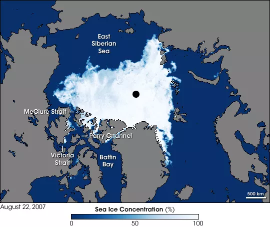
But this feat will only be possible because of something that’s been lost. Arctic sea ice.

“A generation ago, this voyage simply could not have been made,” Rutherford says. “Not because sailors lacked the skill, but because the Arctic was still locked down in ice. And that’s something I hope this expedition will help people understand.”

The challenge ahead


Rutherford is only 21 days into the official expedition at the time of speaking to Arctic Today, Having said that, he notes with a laugh, he’d already sailed some 2,800 miles (4,500 kilometres) from Annapolis, Maryland just to get to his Greenland start line.
 
Matt Rutherford departs Annapolis for Greenland, where he will begin an attempt to become the first person to circumnavigate the Arctic solo and nonstop by sailboat.

If all goes to plan, Rutherford will return to Aasiaat in early October after 90 to 100 days at sea aboard his 42 foot (13-meter) Valiant sailboat.

As he gets further along, Rutherford will start to lose the 24 hours of light that he is enjoying right now in the empty waters above Ireland.
And with the longer darkness periods he will face the combined treachery of floating ice sheets and the rocky archipelago ahead.

“Now if the weather’s good, I can sleep for as long as five or six hours. But up in the north, I will only snatch 30 minutes here and there.”

The 45-year-old founder of the Ocean Research Project already has notched up his share of solo expeditions, including a solo trip across the Atlantic in his early 20s.
He also holds two Guinness World Records for his solo circumnavigation of the Americas, a journey that included the Northwest Passage.
 
On April 21, 2012, Matt sailed into the harbor of Annapolis, MD, marking a record-setting 309-day, 27,077 mile sail around the Americas.
Alone. Non-stop. Hear how -- and why -- he did it.
 
Weather not the biggest uncertainty

To complete this feat, Rutherford must sail nonstop and unassisted.
That means no anchoring, no stepping ashore and no outside help.
He must also weather every storm alone at sea. Despite two Guinness world records and years of experience sailing solo, Rutherford gives himself a 75 percent chance of success.

Surprisingly, his biggest uncertainty is not the weather. In the Arctic, navigating bureaucracy has become just as tricky as sea ice and storms.

“Russia would be probably my biggest obstacle,” he says.
For almost a month, he will sail Russia’s Northern Sea Route, where heavy pack ice, shifting sea conditions and geopolitical uncertainty combine to make this the most dangerous leg of the voyage.

Despite the Russian authorities introducing an exemption for pleasure craft last year, allowing him to obtain a permit to sail the route alone, Rutherford says: “Anything could still happen. Someone could decide I need to come ashore for questioning or an official inspection. And that would be it.”

Communications along this route will also become much more limited.
Starlink is banned in Russian waters, which will force Rutherford back onto the much slower Iridium satellite network that was originally optimised for phones before mobile internet.

“Starlink is a relatively new thing,” he says.
“When I sailed around the Americas, I spent 309 days alone in the ocean, with only Iridium,” he says. “So, I’m used to it.” 
Rutherford also sailed across the Atlantic alone twice even before Iridium. “Back then,” he says, “I had no weather forecast at all.”

Now, when conditions allow, Rutherford can conduct media interviews, keep in touch with friends, follow the news and even duck below deck and download a Netflix movie, all while being alone at sea.
He jokes that the constant flow of news is a mixed blessing, as he isn’t always keen to hear the latest political developments from back home in the U.S.
 
Sailing across an increasingly fragmented Arctic. Photo: Ocean Research Project

Climate research put on hold

The mention of U.S. politics reminds Rutherford of another reason he is now alone at sea. 
 “The only reason I’m getting to sit here is that our funding was cut,” he says.

As founder of a science research non-profit, Rutherford would normally be spending the Arctic summer in Greenland conducting climate research with his team.
But after the Trump administration cut U.S. polar research funding by 88 percent through the now disbanded Department of Government Efficiency (DOGE), many of those projects had to be cancelled.

“So ultimately what I’m trying to do with this voyage is promote the non-profit and the work we do,” Rutherford says. 
“And these big crazy single-handed trips get a lot more PR than research papers.”

Rutherford is careful not to overstate what a single expedition can prove. 
“It’s just another data point when it comes to the melting of Arctic ice and climate change,” he says.

Since he started working in Greenland nine years ago, Arctic sea ice has declined by around one third. On one glacier his team has monitored, the ice has retreated 4.5 miles (7.2 kilometers).
In the same area, water temperatures they measured have risen from around 1.5°C to 3°C.
“It’s the long-term trends that matter,” he says
 
Matt Rutherford preparing to lower a probe into the ice. Photo: Ocean Research Project

The ultimate wilderness

Rutherford’s path to becoming one of the world’s foremost solo sailors began a long way from the ocean.
Raised in Ohio, he spent the first 10 years of his life in a religious cult.

“It was run by a woman named Dorothea who controlled me, my father and my mother,” Rutherford recalls.
“You know, she controlled everything down to the wallpaper you could have, or the car you could drive or the books you could read. And obviously you couldn’t have friends outside… It was a closed group.”

When his parents eventually got out, the family fell apart.
“It was as if the cult had been holding my parents’ marriage together,” he says.
Angry and adrift, the teenage Rutherford ended up on the streets.
By the age of 16, he’d been arrested five times. 
“I basically grew up in juvenile detention centers and rehabs.”

Then, in his early 20s, Rutherford bought himself a dilapidated boat and taught himself to sail.
“I’d always been drawn to nature and the outdoors, and the ocean is kind of the ultimate wilderness,” he says.

Now alone in one of the world’s most remote oceans with weeks of solo sailing ahead, Rutherford seems to have found what he was looking for.
 
Aerial view of Matt Rutherford on board his 42-foot Valiant Photo: Ocean Research Project

Follow this link to track Matt Rutherford’s progress: oceanresearchproject.org
 

Sunday, August 2, 2026

One of the world's rarest animals has been caught on camera – and the photo is extraordinary


Say hello to Mรฃhina, an all-white humpback whale
Image credit: Jono Allen Mรฃhina/WNPA


From ScienceFocus by Tilda Howard

This picture of Mรฃhina, an all-white humpback whale, won the 2026 World Nature Photographer of the Year competition.

Seen here swimming with her protective mother, two-year-old Mรฃhina, which means ‘moon’ in Tongan, is a true rarity – only 1 in 40,000 humpback whales is born with this lack of colouration.

The cause of her ghostly complexion is a topic of debate among scientists: it could be either albinism or leucism.

Albinism is a genetic mutation that prevents the production of melanin, the pigment that colours the skin, hair and eyes in mammals.

But Mรฃhina’s eyes are black, not the red typically seen in albino animals, prompting many scientists to argue in favour of leucism – a partial lack of pigment. 

But it’s not as clear-cut as that, as Migaloo, another famous white humpback whale (below), demonstrated.First spotted in 1991 in Australia’s Byron Bay, it was long thought that Migaloo had leucism, thanks to his black eyes.

But when samples of his skin were analysed in 2011, they showed he was actually an albino.

Regardless of Mรฃhina’s true nature, as Jono Allen, the photographer who took this award-winning image, points out: “Sightings of such rare individuals renew hope in what can happen when conservation is championed and wildlife is allowed to thrive."

Links :

Saturday, August 1, 2026

Friday, July 31, 2026

New Zealand’s ‘rocket man’ takes on Elon Musk and Jeff Bezos

 
Peter Beck founded Rocket Lab in 2006 with the goal of launching lightweight rockets more cheaply © Rocket Lab

From FT by Nic Fildes in Auckland 
 
Peter Beck’s Rocket Lab builds out internet satellite business to rival Starlink and Amazon Leo

After successfully launching New Zealand’s first rocket into space, billionaire Sir Peter Beck is setting his sights on taking on Elon Musk and Jeff Bezos in the internet satellite business.
Last month, the Rocket Lab founder signed the biggest cheque of his life, agreeing to pay $8bn for US-listed satellite communications provider Iridium.
The deal adds a valuable network and spectrum — often called the “lifeblood of the mobile industry” — to the New Zealand-founded business, which makes and launches rockets and other space components.
“It’s a big swing for Rocket Lab to go and buy something like that, but at the end of the day it’s a positive cash-generating business that’s well established,” Beck told the FT.
 
 
A test of Rocket Lab’s Archimedes vacuum engine © Rocket Lab

Founded in 2006 with the goal of launching lightweight rockets more cheaply and frequently than traditional methods, Rocket Lab is a smaller rival to Musk’s SpaceX and Bezos’s Blue Origin in terms of valuation.
It made its first successful launch in 2009, and by 2017 its orbital Electron rockets had emerged as a competitor to SpaceX’s Falcon 9 for satellite launches.
“When you compare us to Jeff and Elon, we are definitely the plucky upstart,” said Beck. 
“You don’t hear me talking about mining asteroids orbiting Mars,” referring to Musk’s vision for space mining.
The Iridium deal fulfils Beck’s long-held ambition to expand into satellite services.
It also puts Rocket Lab into further competition with Musk and Bezos, who have expanded their Starlink and Amazon Leo satellite networks.
SpaceX bought EchoStar’s spectrum for $17bn last year and Amazon acquired Globalstar for $11.6bn in April.
By purchasing Iridium’s network and spectrum over building their own, “we’ve short-cut that by 10 to 20 years”, said Beck.
He added that Iridium would benefit from Rocket Lab’s launch infrastructure to reduce the cost and risk of launching a new constellation in the future.
“Whoever has the rocket has the keys to space,” he said.
 
 
The acquisition of Iridium gives Rocket Lab a valuable satellite network © Justin Ide/Bloomberg

The acquisition comes at an awkward time for the industry. Rocket Lab’s shares have fallen by more than half from their peak in May as the mania around SpaceX’s initial public offering cools.
Beck’s sale of 5mn shares for $465mn has added to the pressure.
The chief executive said Iridium, which unlike Rocket Lab is already profitable, would add a strong customer base and “an incredibly defensible high-value niche” in areas such as maritime communications. Beck said Rocket Lab would look to expand those services.
Luke Pearce, an analyst at CCS Insight, said the acquisition would accelerate competition in the booming sector for low Earth orbit (LEO) satellite services. “This creates another credible LEO competitor alongside players such as SpaceX, Amazon Leo and AST SpaceMobile,” he said.
Rocket Lab has been an extraordinary success story for Beck and for New Zealand.
A far-flung sheep farm on the thinly populated east coast of the North Island is now a hotspot for rocket launches.
The country ranks third for the number of rockets launched, behind the US and China, as its remote location has proved ideal for firing projectiles into space without disrupting aviation and maritime traffic.
 
Rocket Lab conducts most of its launches from a remote site in New Zealand’s Mฤhia Peninsula © Rocket Lab
 
In the three months to March, the company reported revenue of $200mn, up more than 60 per cent from a year earlier, and narrowed its net loss to $45mn from $60mn.
Valued at $40bn, Rocket Lab is by far the largest company to emerge from “the land of the long white cloud”, which has historically produced national champions from its dairy and white-goods sectors. Despite the recent fall, its shares are up nearly 600 per cent since its 2021 Nasdaq offering.
The listing minted more than 100 millionaires in New Zealand. Former employees have gone on to found some of the country’s most promising start-ups including ag-tech company Halter, automotive supply chain group Partly and local rival Dawn Aerospace.
Rocket Lab relocated its headquarters to California in 2013 and has become a key supplier to the US defence department, but it still launches most of its rockets from a remote site in the North Island’s Mฤhia Peninsula.
Its large manufacturing facility east of Auckland sits at the base of a sedate cul-de-sac where pลซkeko swamp hens peck at the lawns. Inside the factory, 1,000 people assemble rockets under giant New Zealand and American flags.
 
Rocket Lab relocated its headquarters to California in 2013 and has become a key US defence supplier © Rocket Lab
 
Beck credits his father for igniting his aerospace passion during his youth in Invercargill, on the tip of New Zealand’s South Island.
The engineer recalled how his father would point at the stars and say: “There could be someone standing there looking back at you.”
“That for me was bigger than anything in my brain,” Beck said, and gave him a “soft spot for the planetary stuff”.
Rocket Lab’s previous acquisitions include companies that supply wheels, cameras, robotics and other essential components used for missions to Mars, Venus and the Moon.
Iridium represents a new frontier for the company.
“You definitely make your own luck, but it was fortunate that all of those stars aligned,” Beck said of the deal.

Links :

Thursday, July 30, 2026

British Isles & misc. (UKHO) layer update in the GeoGarage platform

 1 new chart added and 28 nautical raster charts updated

How tanker data revealed a $13 billion question about Venezuelan oil revenues


A recent Financial Times analysis estimated that the US administration has collected more than $13 billion in revenues from Venezuelan crude exports since January 2026.
Rather than relying on official financial disclosures, the analysis combined Kpler's tanker-tracking data with Argus Media's crude price assessments to estimate the value of exported cargoes.
Beyond the political implications, the article demonstrates how shipping data is increasingly being used to quantify commodity flows and estimate financial outcomes where official reporting is limited.

The key figures

Several figures stand out from the analysis:
  • More than $13 billion in estimated oil revenues generated from Venezuelan crude exports since January 2026.
  • Approximately $300 million publicly recorded as transferred back to Venezuela through the government's online tracking portal.
  • Oil accounts for around 25% of Venezuela's GDP, making export revenues a major contributor to the country's economy.
  • Following the June earthquakes, the United Nations estimates reconstruction costs of approximately $37 billion, increasing the importance of access to these revenues.
Taken together, these figures highlight the gap between estimated export revenues and the amounts that have been publicly reported as transferred to Venezuela.

Shipping data as a source of financial intelligence
 
One of the more interesting aspects of the Financial Times investigation is its methodology.
The revenue estimates were derived by combining tanker movements tracked by Kpler with price assessments from Argus Media for Venezuela's principal crude grades, including Merey, Boscan and Hamaca.
This approach illustrates how maritime data has become an increasingly valuable analytical tool.
Vessel movements provide visibility into export volumes, while commodity price assessments allow analysts to estimate the value of those exports with a reasonable degree of confidence.
As a result, shipping data is now used well beyond operational and logistics purposes. Investors, commodity traders, policymakers, sanctions specialists and journalists increasingly rely on vessel-tracking data to monitor trade flows and assess market developments.
 

The transparency gap

The article also highlights differing public statements regarding the management of Venezuelan oil revenues.
The January Executive Order described the United States as acting in a "custodial" capacity for the revenues.
The Department of Energy subsequently stated that the funds would benefit both Americans and Venezuelans.
President Trump later said the United States had recovered the costs of the operation "28 times" and was "making a lot of money" from Venezuelan oil.
At the same time, lawmakers from both Republican and Democratic parties have called for greater public reporting on how these revenues are being managed.
The differing statements, combined with limited public disclosure, have led to increased scrutiny of the administration of these funds.

Venezuela's economic performance

The article also considers the apparent disconnect between improving conditions in the oil sector and broader economic performance.

Despite:
  • higher realised oil prices following sanctions relief;
  • increasing oil production; and
  • legislation intended to encourage foreign investment,
Venezuela's economy expanded by only 2.5% in the first quarter, its weakest quarterly growth in almost five years.

Economists cited by the Financial Times suggest that one possible explanation is that not all export proceeds have entered the Venezuelan economy.
While this is presented as one potential factor rather than a definitive conclusion, it offers a possible explanation for why stronger oil sector performance has not translated into faster economic growth.

A broader takeaway

The article provides another example of how maritime data is reshaping market transparency.
Where official reporting is incomplete or delayed, vessel-tracking data can provide an independent means of estimating export volumes and, when combined with pricing data, the value of commodity flows.
For those involved in shipping, energy or commodity markets, this reinforces the growing role of maritime intelligence.
Shipping data is no longer used solely to monitor vessels and cargoes; it has become an important source of insight into trade flows, commodity markets and the economic consequences of geopolitical events.

Links :

Wednesday, July 29, 2026

France had never seen a ‘fire cloud’ until this month’s record-smashing blazes


Photograph: Maximilien Lamy/Getty Images
 
From Wired by Brian Kahn

Firefighters in France are confronting a phenomenon never seen in the region before: fire clouds.
It’s a sign of the intensity of the blazes burning—and how climate change is upping the odds that they appear.

A wave of fires has swept over France and Spain, sending hundreds of thousands fleeing.
Firefighters on the front lines are facing what a spokesperson for the French firefighter association told AFP said was an “operational impossibility”—in other words, a “natural force beyond our control.”

As evidence of how out of control the wildfires in France are, look no further than the skies where the blazes have, in some cases, created their own weather.
To form a fire cloud—what meteorologists call a pyrocumulonimbus or the even more metal-sounding cumulonimbus flammagenitus—you first need heat, which fires have in spades.
 
image : Romain Perrocheau / AFP / Getty Images
 
But just as important are dry conditions near the ground and cool, relatively moist conditions aloft in the atmosphere.
As superheated smoke rises miles above the flames and into the cool atmosphere, water vapor condenses around the particles of ash to form water droplets.
(Yes water vapor and water droplets are two different things.) As the air keeps rising, those water droplets eventually become ice crystals.

At this point, the smoke and water droplets have created a cloud, but unfortunately one that’s unlikely to provide much relief in the form of rain.
Instead, these towering fire clouds can unleash lightning strikes that start more fires and generate powerful downdrafts that reach the ground to fan flames further.
At their worst, pyrocumulonimbus clouds can even spawn tornadoes.
Image
Pyrocumulonimbus clouds have been documented in the US, Canada, and Australia, among a handful of other locations.
 

But until now, there were no documented fire clouds in France.
While the country is no stranger to wildfires, the size and ferocity of this summer’s blazes is well outside the normal.

Last week was France’s single most destructive week for wildfires over the past 20 years, according to data from the European Forest Fire Information System.
It more than doubled the previous record during that period, which coincides with accurate satellite data.
This isn’t an isolated bad week either. More than 220,000 acres have burned across the country so far, six times the annual average.
That’s 61,000 acres higher than the previous yearly record.


If that sounds like a familiar trend, well, it unfortunately is.

Burning fossil fuels has heated the planet up, making explosive wildfires more common and destructive around the world.
A 2024 study found the incidence of extreme fires globally more than doubled from 2003 to 2023.
Six of the seven most extreme years have happened since 2016.
 

photo : Patrice Gaulupeau
 
After a slight weekend reprieve as temperatures dipped, they’re expected to rocket back up above 104 degrees Fahrenheit (40 degrees Celsius) in France and 108 degrees Fahrenheit in Spain later this week.

That means firefighters will have to contend with more extreme fire weather—including the possibility of clouds created by the blazes themselves.
 
Links :