Saturday, September 28, 2013

World's most extreme fisherman


Human Planet joins Sam Niang, a Laotian fisherman, as he walks a high wire strung above the raging Mekong River rapids on an extraordinary commute to work.

Rivers provide the essentials of life: fresh food and water.
They often provide natural highways and enable us to live in just about every environment on Earth.
But rivers can also flood, freeze or disappear altogether!

Friday, September 27, 2013

Global warming and oceans: what are the known unknowns?


Warm Ocean Melting Pine Island Glacier
For five years an international team of experts, led by NASA emeritus glaciologist Robert Bindschadler and funded by the National Science Foundation and NASA, planned and orchestrated a mission to drill through the floating ice shelf of the Pine Island Glacier.
Finally they persevered over harsh weather conditions, a short Antarctic field season, and the remote location of the glacier, and installed a variety of instruments to measure the properties of the ocean water below the ice shelf.

From The Guardian

The world's leading oceanography experts examine global warming and the oceans in Abraham et al. (2013)

Understanding how humans are changing the climate requires experts from many different areas.
Physicists, chemists, engineers, mathematicians, biologists, atmospheric scientists, oceanographers, social scientists, the list goes on.
Scientists studying the Earth's climate work out descriptions of how humans are interacting with the environment, how those interactions cause changes, and how measurements can be made.
The methods that have been developed to measure the Earth's climate include true engineering marvels.
There are instruments on satellites that measure the rising sea levels and surface temperatures of oceans, land surfaces, and atmosphere.
But satellite instruments can't see below the surface.

Perhaps the most important component of the Earth's climate, and perhaps the hardest to measure, is the oceans that cover over 70 percent of the Earth's surface.
Over the past decades and even centuries, humans have used various techniques to measure oceans, from buckets that were dragged through the ocean waters to collect samples, to modern autonomous devices that measure the oceans day and night throughout the year and report data by satellite.
A major new development since about 2005 is use of floats that pop up and down to sample the top 2000 meters of the ocean for temperature and salinity.


These enable us to calculate the increase in heat and the changes to the acidity of the ocean waters.
It seems logical that throughout the decades, as our measurements have become more sophisticated, our understanding of the oceans has improved.
That much is true.
But, from a climate perspective, we must address how today's oceans differ from the oceans 10, 20, or 100 years ago.
Sure, the oceans are warmer now because humans have loaded the atmosphere with heat-trapping gases, but how much warmer?
How do we compare today's sophisticated measurements with yesteryears crude ones?
For instance, if measurements in past decades were biased or their assessed depth was off, it could appear that the oceans have not warmed much in certain periods.
Such errors would also have tremendous consequences for our predictions of what the climate will be like in the future.

This complicated topic is the subject of a recent paper my colleagues and I published in the journal Reviews of Geophysics.
Nearly 30 of the world's top oceanographers collaborated on a massive study that not only went back through the history books to describe the evolution of ocean temperature measuring methods, but also looked forward to future measuring techniques.
The paper found that while all the evidence shows the Earth is warming, without pause, there are still unanswered questions and unmeasured parts of the oceans.
Underneath ice sheets and deep in ocean basins are just two regions that need more attention.
One of the world's pre-eminent oceanographers for, among other things, his important work measuring heat transferred to very deep ocean waters, is Dr. Gregory C. Johnson.
Dr. Johnson works as an oceanographer at NOAA's Pacific Marine Environmental Laboratory in Seattle, Washington; he is also a co-author on the paper. He notes,
"This review points to the need to expand the innovative, year-round, broad-scale measurements of the upper half of the open ocean volume so successfully pioneered by the international Argo Program all the way down to the ocean floor and into the ice-covered polar regions, so we can make well-resolved, timely, and truly global assessments of the amount of heat being absorbed by the ocean."

Arctic Sea Ice Minimum
After an unusually cold summer in the northernmost latitudes, Arctic sea ice appears to have reached its annual minimum summer extent for 2013 on Sept. 13, the NASA-supported National Snow and Ice Data Center (NSIDC) at the University of Colorado in Boulder has reported.
Analysis of satellite data by NSIDC and NASA showed that the sea ice extent shrunk to 1.97 million square miles (5.10 million square kilometers), the sixth-lowest on record.
This animation shows daily Arctic sea ice extent and seasonal land cover change from May 16 through Sept. 12, 2013, the day before the sea ice reached its minimum area of coverage for the year.
The data was provided by the Japan Aerospace Exploration Agency (JAXA) from their AMSR2 instrument aboard the GCOM-W1 satellite.

In short, we are doing well, but we could do better with more deep-ocean measuring equipment.
A similar reaction comes from Dr. Kevin Trenberth, who not only is one of the world's top climate scientists, but is also recognized as a top communicator, winning the 2013 American Geophysical Union Climate Communication Award.
Dr. Trenberth has been quite active in ocean heating studies, most recently publishing an important paper which calculated significant rates of heating in the ocean.
He described this new study as,
"an excellent review of the history of ocean observations and very revealing about the problems, the issues, and the advances. Most people don't realize the state of the science of ocean observations and this paper is in that sense an expose."
Drs. Johnson, Trenberth, and others who study climate change every day are hopeful that their work will help us quantify how much climate change has occurred and what the future may hold.
While climate science, like other scientific endeavors does not package answers in neatly wrapped exacting answers, what we can say with certainty that is the Earth is warming and the best place to measure that warming is in the oceans.

The best ocean measurements show a continuous heating that is largely from human-emitted greenhouse gases, and it is an important component of sea level rise.
Indeed sea level rise may be the best single indicator of a warming planet: the other major contributor is additional water from melting land ice.
Since satellite altimeters were placed in orbit in 1992, sea level has risen at 3.2 mm/year.
That should be alarming to everyone.

Links :
  • AWI :  Long-term data reveal: The deep Greenland Sea is warming faster than the World Ocean

Thursday, September 26, 2013

NOAA publishes new editions of Eastern Long Island Sound Nautical Charts

 >>> geolocalization with the Marine GeoGarage <<<

From NOAA

Vessels transiting eastern Long Island Sound now have access to updated nautical charts that will make sailing safer and more efficient in this busy area.

The new editions of charts 13217 (Block Island) and 12372 (Long Island Sound, small craft) cover areas that are critical to navigation and which, for the most part, had not been surveyed since the 1960s.
They identify two dozen new dangers to navigation, and incorporate new shoreline for Faulkner Island, Goose Island, and the port of New London.
Maritime officials in the area welcomed the new editions.

“The updated hydrography depicted in the highly traveled area south of Fisher’s Island and Watch Hill as well as updated shoreline delineation of the adjacent land masses will significantly improve the margin of navigational safety for boaters and commercial shipping,” explained retired Coast Guard Capt. Chuck Beck, who is now transportation maritime manager for Connecticut’s Department of Transportation.

NOAA Ship Thomas Jefferson acquired the new bathymetry, shown here,
for charts 12372 and 13217.

NOAA cartographers revised the charts using 70 square nautical miles of hydrographic data and new shoreline images acquired by the NOAA Ship Thomas Jefferson and NOAA aircraft.
Thomas Jefferson acquired the survey data while participating in a collaborative Long Island Sound seafloor mapping program with the states of Connecticut and New York, and the U.S. Environmental Protection Agency.
In addition to providing information necessary to update nautical charts, the Thomas Jefferson data will give the state and federal government agencies valuable information for ocean planning.

"Ocean floors are amazingly dynamic, and we have to chart those changes to provide precise and accurate navigational data for today's maritime economy," explained Cmdr. Lawrence Krepp, who was commanding officer and the chief scientist of the Thomas Jefferson.
"Our data is used to update NOAA's nautical charts, but the hydrographic information can also support a number of other uses, ranging from fisheries management to alternative energy siting and ocean use planning."

Intracoastal Waterway Route “Magenta Line” on NOAA Nautical Charts

 See more information on the history of the Intracoastal Waterway Route

From Federal Register from Rear Admiral Gerd Glang (Director, Office of Coast Survey, National Ocean Service, National Oceanic and Atmospheric Administration)

Since 1912, a series of nautical charts of the Intracoastal Waterways, produced by the U.S. Coast and Geodetic Survey and, subsequently, NOAA, have depicted an Intracoastal Waterway Route, a “recommended route” known to recreational boaters and commercial mariners as “the magenta line.”
Coast Survey originally added the line to the charts to show the best route through the Intracoastal Waterway but it has not been consistently maintained since its last comprehensive update in 1936.
Aware of safety concerns, NOAA's Office of Coast Survey is removing the “recommended route” from NOAA nautical charts.

In 1938, Chart 830 explained the route depiction.

We are also issuing a Local Notice to Mariners, advising caution in using the line in charts where it has not been removed.
The Office of Coast Survey invites written comments about whether NOAA nautical charts should depict a recommended route through the Intracoastal Waterways.

 Intracoastal waterway in Miami
>>> geolocalization with the Marine GeoGarage <<<

Background 

The first known appearance of what is commonly referred to as the “magenta line” is in a set of eight charts (each titled “U.S. Coast and Geodetic Survey INSIDE ROUTE”) included in a now-defunct U.S. Coast & Geodetic Survey publication, Inside Route Pilot, 1st edition 1912.

As a sample, the chart edition from 1913
NOAA Historical Maps & Charts Collection

The U.S. Coast & Geodetic Survey published seven editions through 1935, when their depiction of the Intracoastal Waterway Route underwent a major update.
As the agency pointed out in their 1935 annual report, “the existing [pre-1935] charts of this system of waterways have been based principally on surveys made from 60 to 80 years ago and, necessarily, are obsolete in many respects.”


The U.S. Coast and Geodetic Survey received substantially more appropriations from the Public Works Administration in 1935, which allowed the agency to update the Intracoastal Waterways Route on nautical charts.
“[W]hile the entire area has not been surveyed, by concentrating on the through route and its most important tributaries, sufficient field surveys have been made so the charts of the entire route can be produced,” the agency director reported.
At some point, the Inside Route Pilot was discontinued (the latest edition in the NOAA Central Library is from 1936) and USC&GS changed its charting system.
Beginning in 1936, the “Inside Route” series of charts were absorbed into the Intracoastal Waterway nautical charts.
From 1936 to the present, the Intracoastal Waterway Route has remained on Intracoastal Waterway charts, largely without changes or updates.

Chart 830, from 1938, shows the magenta line after it was updated by thousands of field workers hired with funds from the Great Depression era's massive Public Works program. 

Current Status of the Intracoastal Waterway Route on Nautical Charts

 courtesy of Water Way Guide

Numerous examples can be found where the charted Intracoastal Waterway Route (“magenta line”) passes on the wrong side of aids to navigation; crosses shoals, obstructions, shoreline; and falls outside of dredged channels, etc.
Coast Survey is taking several actions to address the problems.
First, Coast Survey is systematically removing the Intracoastal Waterway Route “magenta line” from new editions of affected nautical charts.
Second, Coast Survey is preparing chart notes for dozens of charts that are updated but not issued as new editions, and where the magenta line will not be deleted.
Coast Survey will revise the chart notes and publish the revised notes in the Local Notice to Mariners. The LNMs will warn: “The general location of the Waterway is indicated by a magenta line. Mariners are advised to follow the aids to navigation and avoid charted shoals and obstructions.”
Third, Coast Survey is updating the position of the magenta line on current charts (not scheduled for new editions) when authoritative reports or information indicate proper re-positioning.Show citation box
Fourth, Coast Survey is considering the options for future charts: should NOAA continue to depict the “magenta line,” and what should the “magenta line” designate?

The Thin Magenta Line (book from Evelyn Chisolm and Robert de Gast)

Public Comments

The director of NOAA's Office of Coast Survey invites interested parties to submit comments to assist Coast Survey as it decides whether to maintain a new or updated magenta line depicting an Intracoastal Waterway Route on Intracoastal Waterway nautical charts.
Comments may address whether recreational or commercial mariners need a magenta line depicting a specified Intracoastal Waterway Route, and whether that should be a federal government charting responsibility. Additionally, the director specifically seeks comments regarding:
  1. How do you currently access the magenta line? On paper nautical charts, raster navigational charts, electronic navigational charts, commercial paper chart books, commercial charts, or other?
  2. How do you use the “magenta line”? Do you consider it to be a general route, a specific trackline, or a reference line?
  3. Given limited government resources, what are your ideas for how NOAA should develop and maintain a reinstated magenta line?
  4. How do you use the Intracoastal Waterway? Recreationally or commercially? Locally or long distance?
  5. What are your boat's length and draft?
Written, faxed, or emailed comments are due by midnight, December 26, 2013.

Email comments to CoastSurveyCommunications@noaa.gov, or fax to 301-713-4019.
Written comments may also be mailed to Lt.j.g. Leslie Flowers,
Office of Coast Survey, 1315 East-West Highway, #6312, Silver Spring MD 20906.
T : 301-713-2730, ext. 115
E : leslie.z.flowers@noaa.gov

Oracle Team USA wins America's Cup


ORACLE TEAM USA founder Larry Ellison jumped aboard his sleek and swift AC72 moments after the crew had crossed the finish line of Race 19 of the 34th America's Cup, a winner-take-all race.
"I wanted to let them know they'd just won the America's Cup," said Ellison.
"And that's what I told them; that's what I said."
The victory brought to a close the America's Cup in San Francisco.
The event ended on a high note with the captivating match between ORACLE TEAM USA and Emirates Team New Zealand, one that took 19 races in 19 days to complete.

From CNN

There are comebacks -- and then there are comebacks.
As the stars and stripes billowed in the San Francisco wind, Oracle Team USA produced one of the most monumental triumphs in sporting history.
For a team which had stared into the abyss, trailing 8-1 at one stage, Oracle did what nobody outside of its catamaran believed it could do.
Oracle, which defeated the Swiss team Alinghi three years ago, held onto its title when it seemed certain to suffer one of the most humiliating defeats the America's Cup had ever seen.

 Course in San Francisco

"It had everything," said Oracle skipper Jimmy Spithill told Sky Sports.
"It was fantastic. We wouldn't have had it any other way. The guys showed so much heart."
Backed by billionaire Larry Ellison, who owns a 25% in Oracle, the team pulled off a fairytale ending which money just cannot buy.
The 69-year-old, whose personal fortune is estimated at $41 billion by Forbes Magazine, boarded the boat to take part in the celebrations following a titanic tussle.


 After staging an improbable comeback from 7 points behind and with no margin for error, ORACLE TEAM USA has forced a winner-take-all race tomorrow for the 34th America's Cup after sweeping both races today.
ORACLE TEAM USA won Race 17 by 27 seconds and Race 18 by 54 seconds and now stands even with Emirates Team New Zealand on the scoreboard with 8 points each.
Only twice before in the 162-year history of the America's Cup has there been a winner-take-all final race, in 1920 and 1983. In 1920 the defender won and in '83 the challenger won.

The Kiwis have been on match point since last Wednesday, Sept. 18, but now face the possibility of watching the defender stage perhaps the most historic comeback in sport. Already ORACLE TEAM USA has won 10 races, but has 8 points because of a penalty imposed by the International Jury.

The America's Cup is the oldest trophy in international sport -- but rarely has sailing's pinnacle event ever been so dramatic.
It speaks volumes that even those who had barely heard of the event last week suddenly became hooked on a race which has been going since 1851.
And yet this contest should have been all over before Wednesday's fantastic finale with Emirates Team New Zealand having stormed into an 8-1 lead.
In fact, the challenger should have wrapped up the title with victory in race 13 only for it to be abandoned with its yacht just two minutes from the finish line because of a time limit rule.
When the race was rescheduled, Oracle Team USA picked up the win which kept its hopes of a historic comeback alive.
Only on two occasions has the destination of the trophy been unknown going into the final race of the competition.
Oracle has appeared determined to make life difficult for itself since the start of its defense.
The team was given a two point penalty and fined $250,000 after illegally placing lead pellets in their catamarans to gain extra weight.
The incident also cost three crew members their place on the team.

 start line

Racing in AC-72 catamarans, the first time these boats have been used in the competition, the crews expect to sail at around 40 knots or 74 kilometers an hour.
Excitement is never far away -- but then again, never is danger.
Only last March, British sailor Andrew Simpson died after being trapped under a catamaran in an America's Cup training session with Swedish team Artemis.
Last October, the Oracle team came perilously close to an accident of their own, while the Emirates boat has also had its own share of scary moments.
But this past fortnight has brought sailing to the forefront of world sport with Oracle's miraculous fightback set to go down as one of the greatest of all time.
With both teams needing to win the race to get its hands on the trophy, a tight fought affair was expected.

But despite a good start from Team New Zealand, it was the reigning champion which dominated.
Led by Britain's four time Olympic gold medalist Ben Ainslie, who replaced John Kostecki as the team tactician with the score at 4-1, Oracle roared back in dramatic fashion.
Ainslie is the first Briton to experience victory at the event since Charlie Barr led the American team Columbia to three consecutive victories in 1899, 1901 and 1903.
The champagne was in full flow by the time Oracle made it back to dry land with fans in raptures at the side of the port.
"It really is all about the team," added Spithill. "On your own you're nothing, the team make you look great.
"I'm so proud of the boys. We were staring down the barrel at 8-1 but the boys didn't even flinch. It was a fantastic team effort."

Team New Zealand skipper Dean Barker was left inconsolable at the conclusion of the titanic tussle.
He added: "I'm incredibly proud of the team and what they've achieved but gutted we didn't get the last win we needed to take the cup back to New Zealand.
"It's hard to swallow."

Links :

Wednesday, September 25, 2013

Island pops up after the earthquake in Pakistan

 On the Gwadar coastline, the quake created a small island about half a mile into the sea near an area called ‘Jhanda’.
The newly appearing island is said to have a mountainous terrain rising up to a hundred feet.
A large crowd was seen gathering at the site to see the new island.
The island appears to be about 200 metres long, 20 metres high and 100 metres wide.
Photo courtesy Syed Ali Shah

From Dawn

The powerful 7.7-magnitude earthquake that struck parts of Balochistan and Sindh (southwestern Pakistan) on Tuesday was followed by the emergence of an island off the coast of Gwadar.


>>> geolocalization with the Marine GeoGarage <<<

“The island popped up soon after the earthquake. Our staff stationed in Gwadar has reported that the island is about one and a half kilometres away from the coastline,” Dr Asif Inam, the Principal Scientific Officer of the National Institute of Oceanography, said.

SECURITE
251040 UTC SEP 2013
NAVAREA NINE (.) 253 (.) ARABIAN SEA (.) PAKISTAN (.)
GWADAR WEST BAY (.) CHARTS PAK 27, 33, 41, 57 (INT 751),
BA 38 AND 707(.)
2.  UPDATE ON NEWLY EMERGED ISLET IN GWADAR WEST BAY ARE
AS UNDER:
POSITION  : 25-10N 062-16E
DIMENSIONS: 50X20X10 METERS 
   3.  SHALLOW DEPTHS EXPECTED IN VICINITY(.)
4.  MARINERS AND FISHERMEN CAUTIONED.
5.  CANCEL NAVAREA NINE 250 OF 2013. 

The Pakistani HO has issued a radio nav warning
making mariners aware of shallow depths and of the islet itself.

“The island appears to be about 200 metres long, 20 metres high and 100 metres wide. But all this information needs to be verified scientifically. Detailed information will be available tomorrow when the staff visit the site and collect samples,” he added.

An NIO team from Karachi will also visit the site this week.

photo Reuters (video)

Aerial view of the new island off the southern coast of Pakistan in the Arabian Sea.
Boaters are anchored off the island at upper right. 
Credit: National Institute of Oceanography

According to scientists, the Makran coastal belt is reported to have extensive reserves of frozen methane that exist in the form of gas hydrates (crystalline water-based solids physically resembling ice, formed under conditions of relatively high pressures and low temperatures) hundreds of metres below the sea floor.
And whenever this highly pressurised gas finds a weak space to release some of its energy, a dome-like structure (island) is created within the waters or it emerges on the sea surface.


“The space to release energy could be formed due to tectonic movements, creating some fractures and fissures in the strata. Sometimes, the structures do not come out of the water and so go unnoticed,” Dr Inam said.

Explaining the topography of the area, Dr Inam said that it was an active seismic region where three tectonic plates — Indian, Eurasian and Arabian — were converging.
“The area is required to be mapped in detail to ascertain the potentially hazardous parts. Besides, the area could be explored to overcome the energy crisis.”

According to Dr Inam, the analysis of previously tested gas samples taken from the water column of the Malan island showed that it contained methane, ethane, propane and butane.

All data pointed to the presence of microbiologically generated bacterial methane, excluding thermogenic gas.

 >>> geolocalization with the Marine GeoGarage <<<

It’s the third time in 15 years that such a phenomenon has occurred along the Balochistan coast. Earlier, islands emerged in 1999 and in 2011 at a distance of two kilometres from the Makran coast near the point where the Hingol River drains into the sea.

A similar island had appeared in Hangal, the coastal area of Lasbela, three years ago.
The island was there for 4 - 5 months and then it went back into the sea.
A new island formed by a mud volcano emerged offshore of Balochistan, Pakistan on November 26, 2010, and the same spot about a year before it emerged.
Image credit: NASA Earth Observatory

Both islands emerged without an earthquake and collapsed due to strong currents and winds.
The same area witnessed an island’s emergence in 1945, following an earthquake.

Links :

Ocean eddies act like watery black holes, new research shows

Animation of the Agulhas Rings, ocean eddies of the black hole type.


Astronomers may peer deep into the cosmos to study mysterious black holes, but would you believe there are "black holes" right here on Earth?
Well, almost.
A new study by scientists at the Swiss university ETH Zurich and the University of Miami shows that, mathematically speaking, large ocean eddies behave much like black holes.
The watery vortices break off from currents and have their own "coherent" boundaries, as black holes do.
Also like black holes, they swallow anything that gets too close and allow nothing to escape.
"The photon spheres around black holes have the property that anything (except light) is sucked into the black hole through them," study co-author Dr. George Haller, professor of non-linear dynamics at ETH Zurich, told The Huffington Post in an email. "
Similarly, the eddy boundaries we find have the property that anything that floats on the ocean surface (except water) is sucked into the eddy through them."
The eddies can last a year or two, Haller said, though most peter out after a few months.

 Mathematically speaking, ocean eddies are counterparts to the black holes in space.
(Illustration: G. Haller / ETH Zurich)
 
Haller and Dr. Francisco Beron-Vera, a professor of oceanography at the University of Miami, developed a model for identifying the eddies' boundaries using the same mathematics used to reveal black holes' photon sphere boundaries.
Using satellite observations made over the course of three months, they used the model to locate seven "black hole" eddies with diameters of 200-300 kilometers.
A fascinating finding, for sure.
But there's a real-world benefit to finding black hole-like eddies within the oceans.


The mild winters experienced in Northern Europe are thanks to the Gulf Stream, which makes up part of those ocean currents spanning the globe that impact on the climate.
However, our climate is also influenced by huge eddies of over 150 kilometres in diameter that rotate and drift across the ocean. 
Their number is reportedly on the rise in the Southern Ocean, increasing the northward transport of warm and salty water.
Intriguingly, this could moderate the negative impact of melting sea ice in a warming climate.

"Fully capturing the effects of coherent oceanic eddies is a major impetus behind efforts at several climate modeling centers around the world," Dr. Robert Hallberg, an oceanographer with the National Oceanic and Atmospheric Administration's geophysical fluid dynamics laboratory, told The Huffington Post in an email.
The eddies can transport warm, salty water and nutrients far north, acting to moderate the effects of climate change by promoting large-scale mixing in the ocean.
They help counteract the effects of melting sea ice that introduces cold water with low salinity into the oceans, disrupting global circulation.
Identifying eddies may also help scientists predict the movement of polluted water, such as that resulting from an oil spill.
The study was published in the September issue of the Journal of Fluid Mechanics.

Tuesday, September 24, 2013

Mermaids & mermen: facts & legends


From LiveScience (by Benjamin Radford)

Mermaids have long fascinated us.
Humans have always wondered what it would be like to fly high above the clouds or dive deep into the briny seas.
With nearly three-quarters of the Earth covered by water, it's little wonder that centuries ago, the oceans were believed to contain many mysterious creatures, including sea serpents and mermaids.
Merfolk (mermaids and mermen) are of course only the marine version of the half-human, half-animal legends that have captured human imagination for ages (half-animals on land include werewolves, and half-avian creatures include harpies).


C.J.S. Thompson, a former curator at the Royal College of Surgeons of England, notes in his book "The Mystery and Lore of Monsters" that "Traditions concerning creatures half-human and half-fish in form have existed for thousands of years, and the Babylonian deity Era or Oannes, the Fish-god, is represented on seals and in sculpture, as being in this shape over 2,000 years B.C.
He is usually depicted as having a bearded head with a crown and a body like a man, but from the waist downwards he has the shape of a fish covered with scales and a tail."


Greek mythology contains stories of the god Triton, the merman messenger of the sea, and several modern religions including Hinduism and Candomble (an Afro-Brazilian belief) still worship mermaid goddesses.


In secular folklore, mermaids were often associated with bad luck and misfortune, luring errant sailors off course and even onto rocky shoals.
In some legends from Scotland and Wales, however, mermaids befriended — and even married — humans.

'Real' Mermaids?

There are many legends about mermaids, and even a few dozen historical claims of real mermaid sightings.
Though mermaid discoveries are sadly rare in modern times, hundreds of years ago sailors and residents in coastal towns told of encountering the sea-maidens.

One story dating back to the 1600s claimed that a mermaid had entered Holland through a dike, and was injured in the process.
She was taken to a nearby lake and soon nursed back to health.
She eventually became a productive citizen, learning to speak Dutch and performing household chores.
And — perhaps most importantly for the time — she also became a Roman Catholic.

St. John's Harbour, Newfoundland, 1610 from Teodar De Bry's America, 1628.
In his Discourse and Discovery of Newfoundland, Richard Whitbourne recounts sighting a strange creature in St.John's harbour which he identifies as a mermaid.

Another mermaid encounter once offered as a true story is described in Edward Snow's "Incredible Mysteries and Legends of the Sea."
A sea captain off the coast of Newfoundland described his 1614 encounter: "Captain John Smith saw a mermaid 'swimming about with all possible grace.'
He pictured her as having large eyes, a finely shaped nose that was 'somewhat short,' and well-formed ears' that were rather too long.
Smith goes on to say that 'her long green hair imparted to her an original character that was by no means unattractive.'"
In fact, Smith was so taken with this lovely woman that he began "to experience the first effects of love" (take that as you will) as he gazed at her before his sudden (and surely profoundly disappointing) realization that she was a fish from the waist down.

John William Waterhouse – Ulysse and the Sirens (1891) Melbourne

This account combines common folkloric features of early mermaid reports, including a (presumably sober) respected sailor; a beautiful woman who — like the mythological sirens who tortured brave Ulysses of Greek mythology — is immediately enchanting; and the twist ending of suddenly realizing the truth.


By the 1800s, hoaxers churned out faked mermaids by the dozen to satisfy the public's interest in the creatures.
The great showman P.T. Barnum was well aware of the public's interest in mermaids, and in the 1840s displayed the "Feejee Mermaid," which became one of his most popular attractions.
Those paying 50 cents hoping to see a long-limbed, fish-tailed beauty comb her hair were surely disappointed; instead they saw a grotesque fake corpse a few feet long.
It had the torso, head, and limbs of a monkey and the bottom part of a fish.
To modern eyes, it was an obvious fake, but it fooled and intrigued many at the time.

Could there be a scientific basis for any of it?
Some researchers believe that sightings of human-size ocean animals such as manatees and dugongs might have inspired merfolk legends.
These animals have a flat, mermaid-like tail and two flippers that resemble stubby arms.
They don't look exactly like a typical mermaid or merman, of course, but many sightings were from quite a distance away, and being mostly submerged in water and waves only parts of their bodies were visible.
A glimpse of a head, arm, or tail just before it dives under the waves might have spawned at least some mermaid reports.


Modern mermaid reports are very rare, but they do occur; for example, news reports in 2009 claimed that a mermaid had been sighted off the coast of Israel, performing tricks at sunset for onlookers over the course of several months.
Unfortunately, the reports vanished almost as quickly as they surfaced (and without further eyewitness sightings or photographs), leading many to suspect an optical illusion of the waves against the setting sun, or even a hoax to drum up tourism.


Credit (or blame) Animal Planet (a branch of Discovery), which laired a TV show called "Mermaids: The Body Found."
It was a documentary-style show that “paints a wildly convincing picture of the existence of mermaids, what they may look like, and why they’ve stayed hidden…until now,” according to the show’s press Web page.
Indeed, it says, “'Mermaids: The Body Found' makes a strong case for the existence of the mermaid…”

A recent TV movie called "Mermaids: The Body Found" renewed interest in mermaids.
It presented the story of scientists finding proof of real mermaids in the oceans.
It was fiction but presented in a fake-documentary format that seemed realistic.
If the program fooled people, it's because it was intended to; as the show's website noted, the movie "paints a wildly convincing picture of the existence of mermaids, what they may look like, and why they’ve stayed hidden … until now."
The show was so convincing that the National Oceanic and Atmospheric Administration, represented in the film, received enough inquiries following the TV special that they issued a statement in late June officially denying the existence of mermaids.

Though legends of half-human, half-fish seem archaic, mermaids are not merely dusty relics of bygone days.
They are still a vibrant part of our culture and in their images can be found all around us in films, books, Disney movies, and even on Starbucks coffee cups.

Links :
  • Discovery : NOAA denies existence of mermaids

Monday, September 23, 2013

On the trail of sea urchins in the Arctic Circle


From The Guardian

Arctic diver Roddie Sloan was about to abandon his beloved urchins to study engineering, but then he got a call that would change his life...

Our urchin diver is a Scotsman who came to Norway for the love of a woman, and stayed for the cold, pristine waters of his new region of Steigen. If it lives in the north Atlantic and I want to cook it, Roddie will find it and it will arrive at Fäviken neatly arranged in a little box, whether it's edible or not."
Magnus Nilsson, chef, Fäviken, Sweden

  Stronglyocentrotus droebachiensis 
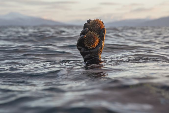
Stronglyocentrotus droebachiensis. Photograph: Howard Sooley

A small icy open boat 300km inside the Arctic Circle: diver Pawel grins as he hands me a holy grail and for a second I forget the biting wind.
The interior of the spiky sea urchin he is holding out is an astonishing tangerine like a Chinese lantern, bathed in low brilliant light.
What I have in my hand is Stronglyocentrotus droebachiensis, the mythical Norwegian Green, talked about in hushed whispers by chefs.
I lift out a delicate coral "tongue" – more accurately, its gonads – and let the umami flavours wash over me: the texture is of wobbly custard; the taste clean, like the smell of the Arctic sea, only sweeter.
I close my eyes and quietly drift with the water.
We have plenty of time and urchins while we wait for Roddie Sloan to reappear from the freezing sea.

 >>> geolocalization with the Marine GeoGarage <<<

Sloan had known this was a good day to fish, he says, because the sea eagle had told him.
"Like most fishermen I have superstitions," he says.
"If I don't see an eagle, I know it will be a bad day."
And winter days here – if you can call barely four hours of dim light a day – can be very bad.
He tells me of a five-hour battle through 4m waves to get his tiny boat the final kilometre home. Luckily, today the fjords are calm, the sun is shining and as we fill the boat with urchins and clams, Roddie Sloan and Pawel "The Fish" Laskowski are happy.

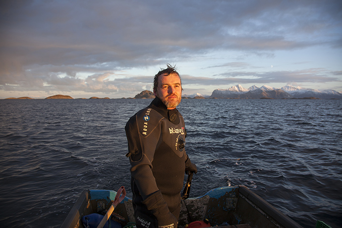
 Roddie Sloan in Nordksot, Norway. Photograph: Howard Sooley for Observer Food Monthly

Just a few years ago, Sloan was ready to quit the sea.
The millions he dreamed he'd make from diving had failed to materialise, unlike his second son (he now has three).
Anxious about how to support his family, Sloan hung up his wetsuit to study engineering.
But then came a phone call that would change his life.
"I remember the day," he tells me later as I stoke the log fire in our borrowed white wooden house on a tiny island in the fjord.
"It was a sunny Sunday, a beautiful autumn afternoon, Lindis [his wife] is making dinner while I am standing on the terrace. The phone rings. It's a chef wanting urchins but I tell him he is too late. It isn't fair to my wife any more, it is over.
"In my mind I already had autumn organised," he continues.
"I was going to university. We spoke for about an hour, about sea urchins and other foods from the sea, but he was a two-star and I had been supplying Le Louis XV [Alain Ducasse's three-Michelin-star palace in Monaco].
I was polite but I wasn't interested.
"When we had finished, Lindis asked who it was," he says.
"Some Danish chef, I told her, calling from Nimrod or Nana, I don't care. I am going back to school."
It was, of course, René Redzepi from Noma.

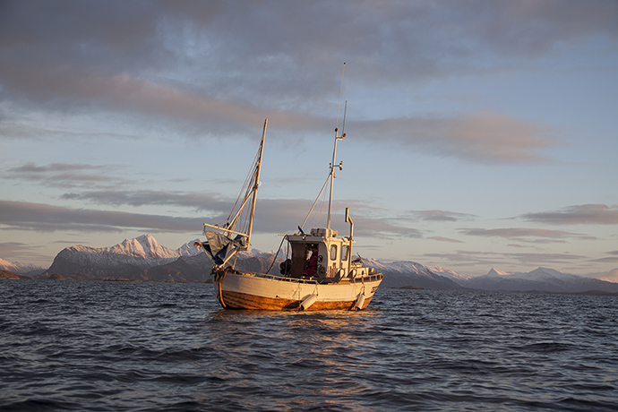
 Sloan borrows a fishing boat to get his dinghy out to the sea urchin beds he has mapped in the closed season the previous year.
Once picked he will not return to the same bed for five years.
Photograph: Howard Sooley for Observer Food Monthly

Under pressure from Lindis – a super-smart Norwegian gender specialist and government adviser – Sloan succumbed but tripled his price: "If you don't want to do something, you hike the cost," he says. "But I didn't want Lindis to be angry."
It was a fragile start to a life-changing friendship
 "With René," he says, "the price doesn't much matter, it is about the product. This was an extremely new experience for me."
But Sloan was intent on leaving the sea. "I still wanted to study, so he was my only client."

A few weeks later, Redzepi turned up.
"He was wearing trainers to go to sea," Sloan laughs.
"He had a new hat, he had duty-free, but was in all the wrong clothes. We kitted him and took him out for four hours. The season was finished, it was minus 22. We talked about changing nappies, about family, philosophy and sea urchins.
"I realised I really like this guy," he says. "I am a loyal dog – once I have made up my mind, it takes a lot to get rid of me. I tell him we will change the price, he tells me he wants 50kg a week."


Next, he ate his green urchins at Noma: "It was a dish of 'frozen pebbles and sea urchins' – an amazing taste sensation, suddenly I saw what he saw."
Sloan, a Scottish economic exile from Dumfries, transplanted to Nordskot, an Arctic hamlet of 80 people, had found another new home.
"Noma has become 'my kitchen' in a way," he says.
"I can drop in for tea, coffee, maybe curl up under a table."
Through Redzepi and his MAD [food] symposium in Copenhagen (Sloan was a reluctant but compelling speaker at the second event in 2012), he has found validation and a viable market with many of Europe's top chefs now clamouring to buy from him.

Sloan with some of his catch. Photograph: Howard Sooley 
 
Fäviken's Magnus Nilsson again: "We met the first time in Copenhagen … I looked into a pair of glistening blue eyes and heard the words, 'I am Roddie the urchin diver, you are my closest chef [they're more than 600km apart by road], we need to work together.'
We soon found a logistical solution that was manageable for us both in terms of money and quality, which involves a couple of ferries, a firm of removal men and a monthly bribe of a box of beer.
The produce arrives every Tuesday at Fäviken and it includes the best sea urchins I have ever seen anywhere."

This season – late September to January – Sloan will also be supplying UK restaurants including St John.
For now at least, wild talk of further education is on hold.
Ask Roddie Sloan about his relationship with his adopted community, the Arctic sea, and its produce, and his voice becomes quieter.
We make tea and talk about Nordskot's oldest inhabitant, 81-year-old Finn Ediassen, who started fishing aged eight and taught Sloan "all I know about ropes and knots".
He tells me how this community nestled at the foot of an austere mountain range at the top of the world had carved a precarious living fishing and whaling but now there was no work; how they had indulged his obsession with the urchins and clams they still only think of as bait.

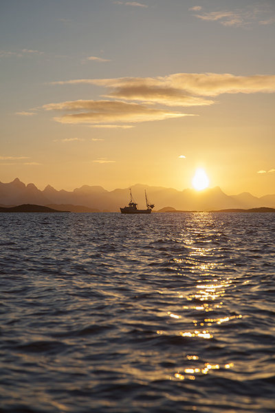
 The midday sun goes down on northern Norway, three or four hours of winter daylight fade.
Photograph: Howard Sooley for Observer Food Monthly

The fire crackles.
The Arctic light dips. Sloan's eyes shine as tells me of his pride in how they have taken him in, recognising a kindred wild spirit bewitched by the sea.
But it is when he talks about being a warden for his beloved urchins that Sloan comes alive.
The green is one of 700 species, 500m years old, he says.
"The quality starts in the sea – how you pick it up with your hand, how many you have in the net. How you handle it, how you fish it.
"They have changed my life, these beautiful creatures," he says.
"My mother doesn't understand it. For her, they are still something my Aunty Jean brought back from her holidays. But they have given me a community, friendships, food. They have given me a place, a proper life."
All the while, a few urchins shyly shift and move as we talk. As daylight finally fades, I watch entranced as they dance on spikes across the kitchen table.
"They are very precious to me," Sloan says softly.
Later, I am sitting drinking smoky scotch when Roddie Sloan calls from his home in the village. "Look outside," he says, simply. "Northern lights."

So I stand on the terrace of my Arctic explorer's island cottage and watch as the sea and sky come alive.
I see electric greens shoot and pulse over the forbidding horizon as though orchestrated to an unheard symphony.
I watch the sky and fjord turn the intense colour of limes and the stark icy mountains take on an unearthly mauve.
And for the next three hours as I drink whisky and watch, I almost envy Roddie Sloan his hermit life, the few hours of daylight, the many hours spent diving in the icy water.
But then I remember the forecast is for more storms, more snow and minus 15 and I shudder and return to the fire.

Links :

Sunday, September 22, 2013

9 unreal photos of body surfers at Teahupoo


From HuffingtonPost

Body surfing is arguably the purest form of wave riding.
The oft-neglected predecessor to surfing was the sport of dolphins ages before any attempt by man.
A few dedicated bipeds, equipped with nothing more than a pair of fins, have mastered the art, and Keith Malloy’s film, "Come Hell or High Water," pays tribute to some of the best body surfers and body surfing breaks in the world.
Photographer Chris Burkard captured these unbelievable shots while helping Malloy film at Teahupoo in Tahiti.
The Plight of the Torpedo People (Woodshed Films/T. Adler Books), a compilation of photographs and stills from the film, was published this year.
You’ve never seen man and water meet like this.

kalima burkard torpedo

kalima under burkard torpedo

cunningham under burkard torpedo

cunningham shootout burkard torpedo

malloy burkard torpedo

homcy burkard torpedo

kalima skin burkard torpedo

cunningham curl burkard torpedo 

group burkard torpedo 

You can follow Chris Burkard's work on Facebook and Instagram @chrisburkard.

Links :