El Niño and La Niña are terms which describe the biggest fluctuation in the Earth's climate system and can have consequences across the globe.
The fluctuation sees changes in the sea-surface temperature of the tropical Pacific Ocean which occur every few years.
What causes El Niño?
These events are due to strong and extensive interactions between the ocean and atmosphere.
They are associated with widespread changes in the climate system that last several months, and can lead to significant human impacts affecting things such as infrastructure, agriculture, health and energy sectors.
The name 'El Niño' nowadays is widely used to describe the warming of sea surface temperature that occurs every few years, typically concentrated in the central-east equatorial Pacific.
'La Niña' is the term adopted for the opposite side of the fluctuation, which sees episodes of cooler-than-normal sea surface temperature in the equatorial Pacific.
These episodes alternate in an irregular inter-annual cycle called the El Niño Southern Oscillation (ENSO).
Southern Oscillation is the term for atmospheric pressure changes between the east and west tropical Pacific that accompany both El Niño and La Niña episodes in the ocean.
ENSO is the dominant feature of climate variability on inter-annual timescales.
Our research helped show that El Niño and La Niña cycle has impacts all over the world.
For example, El Niño years are one factor that can increase the risk of colder winters in the UK.
We now better understand these impacts and reproduce many of them in our climate models.
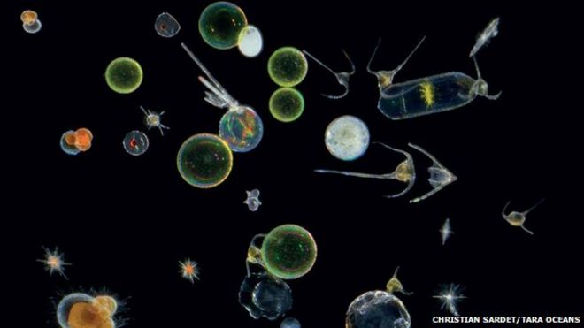
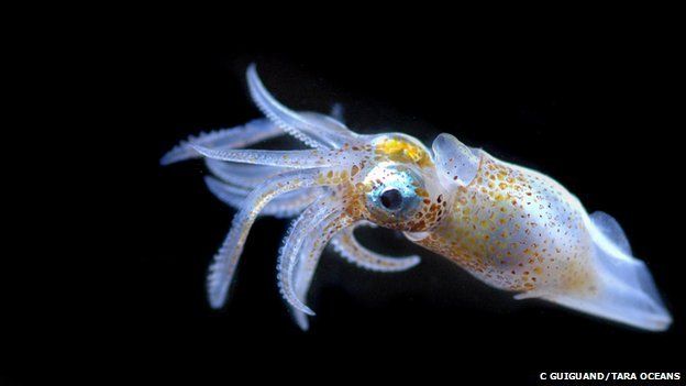
The hidden world of the ocean's tiniest organisms has been revealed in a series of papers published in the journal Science.
An international team has been studying samples of plankton collected during a three-year global expedition.
Planktonic organisms such as these single-celled creatures are found throughout the oceans
They have so far found 35,000 species of bacteria, 5,000 new viruses and 150,000 single-celled plants and creatures.
They believe that the majority of these are new to science.
Dr Chris Bowler, from the National Centre for Scientific Research (CNRS), in Paris, told BBC News: "We have the most complete description yet of planktonic organisms to date: what's there in terms of viruses, bacteria and protozoa - we finally have a catalogue of what is present globally."
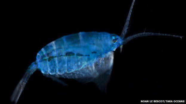
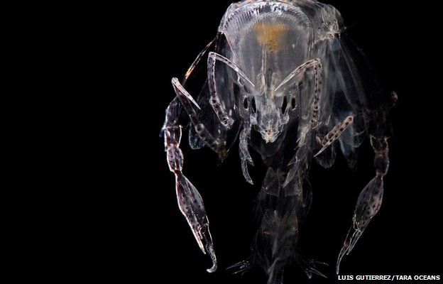
This tiny crustacean was found in a sample taken in the South Pacific
Planktonic organisms are minute, but together they make up 90% of the mass of all of the marine life in the oceans.
They include viruses, bacteria, single-celled plants and creatures (protozoa).
They form the very base of the food chain, and produce - through photosynthesis - half of the oxygen we breathe.
However, until now, little has been known about this unseen ocean ecosystem.
The Tara expedition, primarily funded by the French fashion designer Agnes B, set out to change that.
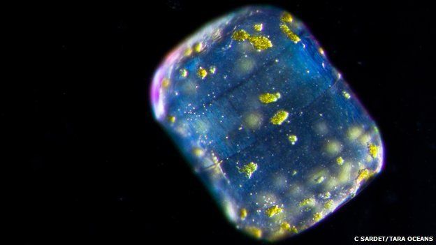
Many of the organisms are new to science
An international team of scientists took part in expeditions onboard the Tara schooner between 2009 and 2013.
It sailed 30,000km across the world's oceans, with researchers collecting 35,000 samples, taking them from the very top layers of the ocean down to 1,000m below the waves.
The project has cost about 10m euros.
So far the team has analysed 579 of the 35,000 samples that were collected
New viruses
So far the scientists have analysed 579 of the 35,000 samples collected, presenting the results in five scientific papers.
Dr Bowler said the research was transforming our understanding of these ocean communities.
"For the viruses, we describe about 5,000 virus communities - only 39 of these were previously known.
"And for protists - unicellular organisms - we estimate something like 150,000 different taxa.
"There are about 11,000 formally described species of plankton - we have evidence for at least 10 times more than that."
The analysis has revealed that many of the organisms are sensitive to temperature
The researchers also looked at how the different organisms interacted
Of the 35,000 microbes found, most had been seen before, however a genetic analysis of them revealed many new genes.
"We have 40 million genes - about 80% of which are new to science," explained Dr Bower.
The researchers also analysed how plankton communities are organised.
"We have thrown all of these together to see who interacts with whom," said Dr Bower.
"We now have a big dataset where we can ask: 'who do you always find with someone else?' or 'who do you never find with someone else'.
"This helps us to describe symbiosis and interactions that go beyond grazing and predator-prey relationships."
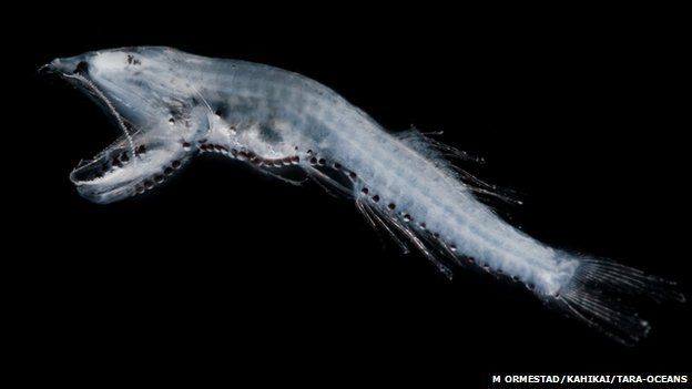
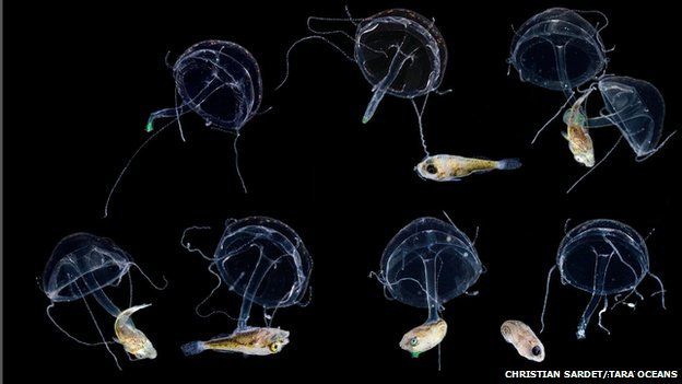
Planktonic organisms such as these tiny jellyfish and fish are found throughout the oceans
'Enormous' database
The researchers have found that many of the organisms, particularly the bacteria, are sensitive to temperature.
Dr Bowler said: "It is temperature that determines what sort of communities of organisms we find.
If we look at our data and we see what organisms are there, we can predict with 97% probability the temperature of the water they are living in.
"These organisms are most sensitive to temperature, more than anything else, and with changing temperatures as a result of climate change we are likely to see changes in this community."
The researchers say that this scientific analysis is just the beginning.
They are making their findings freely available to the scientific community to gain a better understanding of this vital but unseen underwater world.
Dr Bowler continued: "The amount of data we have released is already enormous; it is one of the largest databases of DNA available to the scientific community. But we've analysed perhaps 2% of the samples we have collected throughout the world - so there is a huge amount of work to do in the future to understand even more about the functioning of these marine ecosystems and the importance of that for the wellbeing of the planet.
"So it's really just the beginning of the study."
Links :
QuantaMag : Scientists map 5,000 new ocean viruses
NPR : Census reveals universe of marine microbes at bottom of the food chain
NYTimes : Scientists sample the ocean and find tiny additions to the tree of life
Nature : Global ocean trawl reveals plethora of new lifeforms
Anyone who’s taken a road trip has probably had to use a map at some point.
Navigating from point A to point B isn’t always as easy as it seems.
Imagine what’s its like then to travel the ocean.
How do you know where you are and what’s around you?
Well, there are maps for the ocean too.
These are called nautical charts.
At first glance, a nautical chart may look overwhelming.
But once you learn what the various lines, numbers, and symbols mean, reading these charts becomes a lot easier.
Let’s go over some basics...
Any location on Earth can be described by two numbers: its latitude and longitude.
On a chart, lines of latitude are horizontal while longitude are vertical.
Both are actually angles, measured in degrees.
If a ship captain wants to find a specific location on a chart, these are the coordinates he would use.
You’ll notice numbers all over the ocean areas on nautical charts.
These are actually water depths.
These numbers are especially important to large commercial vessels that need to protect the bottom of their boats in shallow waters.
Nautical charts also use a variety of colored lines, shapes, and symbols to show what you will find from the sea surface down to the sea floor.
Coastlines can often be an underwater obstacle course of sandbars, reefs, and rocks.
Throughout history, a variety of ships have sunk to the bottom of the ocean.
The locations of these shipwrecks may be noted on a chart.
Blue lines are used to distinguish areas of protected habitat, like a marine sanctuary.
These areas may be home to beautiful islands, corals or marine life, some of which are endangered.
Nautical charts are road maps of the ocean – helping sailors, fisherman, explorers, and scientists find their way around the big blue sea.
Master navigator Nainoa Thompson has just been honored in Washington D.C. for “Excellence in Exploration” at the 2015 Peter Benchley Ocean Awards.
He is one of a handful of indigenous navigators left on Earth that can
find tiny islands in the open ocean without instruments, using
wayfinding techniques passed down over a thousand years.
Guided by the waves, stars, and a deep appreciation of their culture,
Master navigator, Nainoa Thompson, and the rest of the Polynesian
Voyaging Society have set a course for a whole renewal of people’s
relationship to the rest of nature.
Thompson, mentored for decades by Micronesian master navigator Mau Piailug, became the
first Native Hawaiian in 700 years to practice long-distance
wayfinding.
As president of the Polynesian Voyaging Society, Thompson
has overseen the 150,000 miles sailed over a span of 40 years by the
traditional voyaging canoe, Hōkūleʻa.
Thompson and the captains and crew of the Mālama Honua Worldwide
Voyage are nearly 10,000 nautical miles into their current voyage around
the world to explore solutions and stories of hope for our oceans and
environment.
Here is what Thompson had to say about the award, the connection
between finding islands and finding a sustainable future, and why he is
feeling hopeful about our ability to mālama honua—care for Island Earth.
Flooding the night sky with reflected sunlight, or giving a point of
reference when clouds block the stars, the moon can have many effects on
traditional navigators.
What does this award mean to you and the Mālama Honua Worldwide Voyage?
The award is not for me, because Hōkūleʻa is the one that has carried
all of us.
I just hold it and carry it for Hōkūleʻa and for Mau, the
true explorers.
If voyaging matters, you have to be able to acknowledge the thousands
of people that sailed Hōkūleʻa, that cared for Hōkūleʻa, that made sure
that she would be safe at sea, and the thousands of people that
supported her.
At the core of that would be the great Mau Piailug that pulled Tahiti
out of the sea and gave pride and dignity to the whole Pacific.
He then
came back for four decades and trained us.
So, I don’t accept this
award on behalf of myself. But it was an honor to be there.
It was
uncomfortable and intimidating, but I learned a lot.
Hōkūleʻa is not sailing in isolation—there are people out
there working for a common goal. What Mālama Honua stories of hope did
you hear at the awards?
I was among people that are great navigators in their own fields.
You
get a strong sense that there is hope among all the scientific evidence
that is not hopeful. Together, they provide starlight that we can
follow as we try to find our way.
Nainoa Thompson gives his acceptance speech at the Carnegie Institution
for Science in Washington, D.C.
So, for me, being there tonight and connecting and building
relationships with these extraordinary people, I think it strengthens
the voyage and gives me a stronger sense of purpose.
We were in a room
full of navigators that against all the odds are doing everything they
can to build a better world—the world our children deserve.
As a navigator, what changes have you seen in our oceans and environment over the past 40 years?
I see less fish, and more fishing boats.
In the early years of
voyaging, we would fish and by morning time we would pull in the lines
because we had enough to eat.
On our last trip to Palmayra we went 1,100
miles, and did not catch a single fish.
I am not saying that it
qualifies as scientific, but we are out there and we see a lot less life
now in the oceans than we did before.
It collaborates with the idea
that 90 percent of the big fishes are gone.
It is a scary time.
Healthy coral reefs full of fish occupy only a small fraction of the
area they once did.
Mounting evidence from the scientific world is painting a really bad
ecological picture of the earth, and the issues of climate change and
global warming are issues of society—whether it is economic, social, or
environmental.
The things that we call “environmental issues” are the
most important issues that humanity has to address across the Earth.
Being with Pacific Islanders—who for thousands of years and
hundreds of generations that have had their wellbeing dependent on the
wellbeing of the oceans—people are worried.
Things that have never been talked about before—new words like
acidification, or dead zones, or hypoxia—all these kinds of new words
are in the conversation among Pacific people.
Across the Pacific, communities are welcoming Hōkūleʻa on her voyage and
getting in touch with deep, traditional understandings of the
interconnectedness of humans and their environment.
And the irony is that Pacific people had no role in creating those
words, and yet they will be the ones that arguably will suffer the most,
first.
And yet at the same time, you see there is this glimmer of hope
because everybody in the Pacific is talking about it now, and people are
coming together, from grassroots and government, and from different
kinds of organizations.
So I do believe that what I see is a human
reaction to their world that’s in trouble, and they are coming together
in a unifying way to make the world better.
It is a scary time, it is a
challenging time, but also a pretty a hopeful time.
A manu—bird, guides Hōkūle‘a on her way.
Navigation has become
more difficult over the years because of fewer seabirds being seen.
Given that the techniques you use for non-instrument
navigation have been passed down through the generations over a
thousand years, how do these changes in the ocean and environment impact
your ability to voyage? Can you maintain your traditions?
Things like the signs of the seabirds—we don’t see the seabirds like
we used to.
That makes it more difficult.
The sea life that we use in
navigation becomes much more comprised.
We still can navigate, but I
would say it is diminished.
And then what do you navigate?
What is the worth of navigation if all
you are doing is accounting for a world that is diminishing?
So, the issue of tying your tradition to the future comes to a
position in which we have to be responsive
It is about responsibility
to nature and the ocean and the earth, which is exactly where we need to
be. I think the great navigators of today are the ones that recognize
the changes in nature and are taking responsibility to do something
about it.
Hurricane Pam, last year, was the first-ever Category 5 hurricane in
the Asian Pacific in the month of May. Climate change is here. It is not
an idea, it’s not a philosophy; it is here.
With the hurricane season
now we are seeing way more intense storms, more days of very dangerous
winds.
There were five major storms in the month of March in the North
Pacific.
That’s unprecedented.
Being a student of navigation, if our
priority is keeping us safe we have to address it and do something about
it.
The navigation is traditional, but the rain gear is modern. Shoes are optional.
There are people saying that going around the world on Hōkūleʻa is
too dangerous; there is too much risk. The great risk of our time is not
sailing Hōkūleʻa.
The great risk of our time is ignorance, apathy, and
inaction.
The signs of nature are navigating us towards a stronger commitment
to responsibility.
We don’t have all the answers; that’s why we sail.
At
the awards, we met a lot of people that are fully 100 percent
committed, compassionate, and caring.
A room full of pioneers and
navigators that are doing their piece of the puzzle to create positive
change.
We wouldn’t be in the room if it wasn’t for the Worldwide
Voyage.
So the voyage is taking us to places that we needed to be.
It
makes us not only more hopeful but it strengthens our sense of purpose
and helps us understand that it is important for us to sail.
Nainoa doesn’t see a major risk for the crew of Hōkūleʻa.
“The great
risk of our time,” he says, “is ignorance, apathy, and inaction.”
For more about the Mālama Honua stories of hope and Hōkūleʻa’s planned arrival in Sydney, Australia this week, please visit www.hokulea.com.
Offshore, the seas glow with the light of hundreds of fishing boats lining up along invisible borders. (NASA Earth Observatory and NOAA National Geophysical Data Center)
A new Earth-viewing satellite sensor that can observe both natural
and artificial sources of visible light at night is providing a treasure
trove of high-quality information for scientists, meteorologists,
firefighters and city planners.
The Day Night Band (DNB) sensor is so
sensitive it can measure the glow of a single streetlamp from its
vantage point 800 kilometers above.
With moonlight, the DNB can observe
clouds, snow and sea ice in almost as much precision as conventional
daytime observations.
Even on moonless nights the sensor can detect
high-altitude pressure waves that modulate the atmosphere’s own faint
glow.
Ship tracks in the East Pacific Ocean, and valley fog in British Columbia
I have presented several major applications of this new technology in “Night Watch” in the May 2015 Scientific American.
A few additional capabilities that emphasize human factors are
highlighted here, which further demonstrate how the DNB is helping
research and operational communities by land and sea.
(Details about the
DNB—part of the Visible Infrared Imaging Radiometer Suite flying on the
Suomi National Polar-Orbiting Partnership satellite—can be found at http://www.mdpi.com/2072-4292/5/12/6717).
Overall, the DNB is helping us realize that nighttime is nowhere near
as dark as we might have thought—and that we no longer need to be “in
the dark” when it comes to operating in the nocturnal environment.
Credit: NASA Earth Observatory (Squid boat satellite image).
Boats on Horizon photo is courtesy of Wikimedia Commons
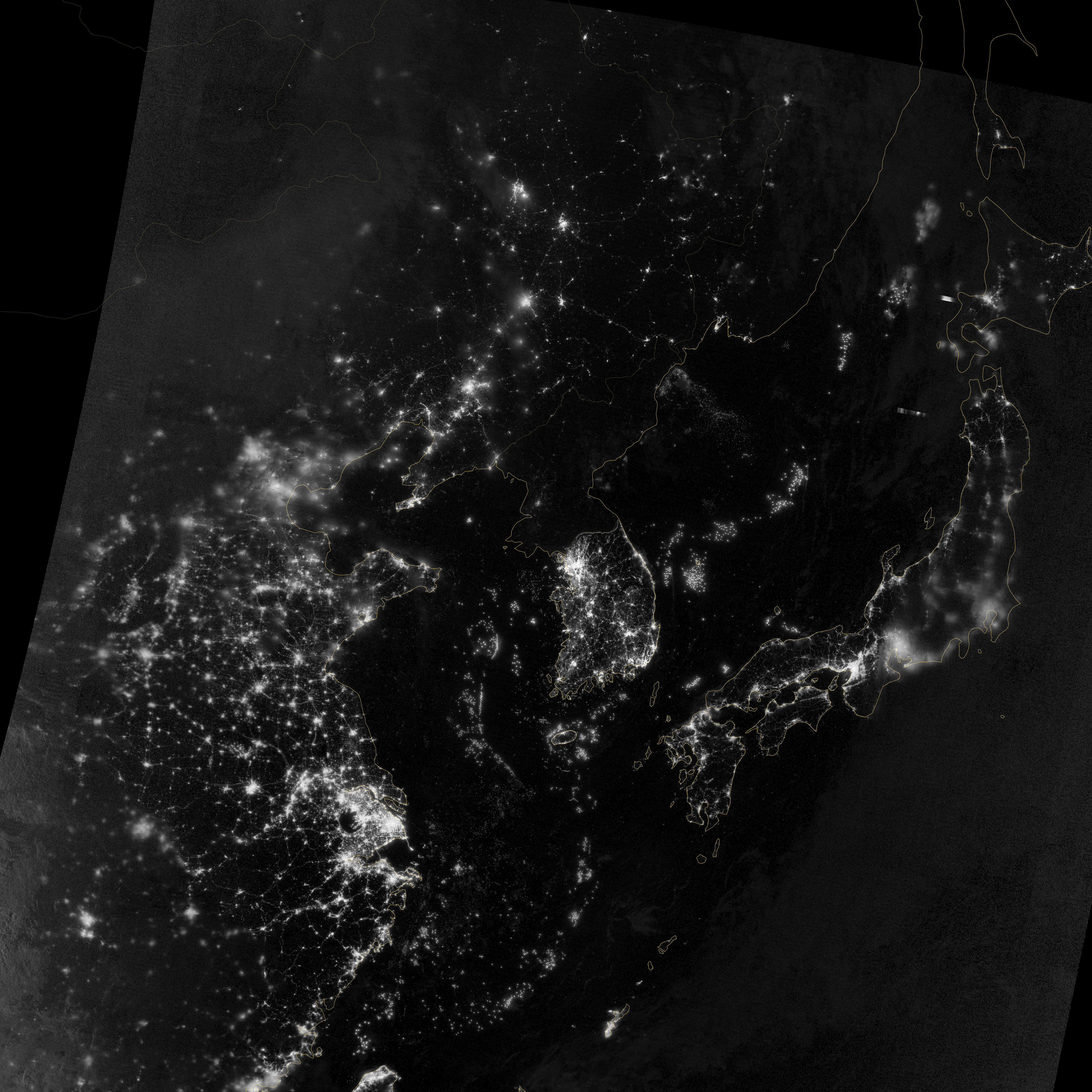
The vast network of electric lights at night shows how connected
civilization is to Earth as an organism.
But it can also provide
poignant commentary on the current state of human divisions.
Sharp
changes in regional lighting often delineate areas of poverty and
economic prosperity, which is perhaps nowhere more prominently displayed
than in the juxtaposition of mostly dark North Korea and well-lit South
Korea (center of left-hand image).
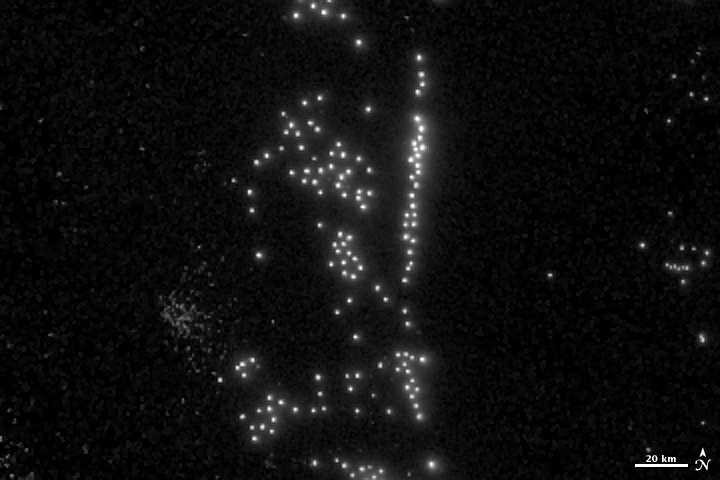
Squid boat fleets sometimes remind us of our divisions as well.
The
DNB can detect individual boats, each appearing as a point of light
against the dark ocean water. The vessels use high-powered lamps to
attract squid to the surface, like moths to a flame (right).
The boats
typically cluster in groups that follow schools of fishes from one night
to the next. Sometimes the orientations of the clusters they form are
tied in a benign way to natural features such as sea-surface boundaries
that help form productive waters.
But in the Yellow Sea and East China Sea regions we can see that these
boats often abut political boundaries that define zones of shared
(provisional) and exclusive fishing rights for China, Korea and Japan.
According to local people, there are two possible reasons for these
unusual alignments: One has to do with boats of another country
attempting to get as close as possible to waters having more squid.
But
another is purely political—the density of ships along these borders
effectively blocks access to the “shared” waters, and could be a passive
display of force related to territorial disputes among the surrounding
nations.
It is a cold war of sorts but also a wet one, as coast guard
ships use water cannon to ward off fishing vessels. Agencies in South
Korea, Japan and Thailand as well as Peru, Argentina and Britain are now
regularly requesting Day Night Band data to see if boats are fishing
illegally.
Ship trails, not contrails
Credit: Images by Steven D. Miller
In less contested waters we see interesting effects of the maritime
community at night as well.
We are all familiar with how the exhaust
from jetliners alters the atmosphere, forming clouds called
contrails—those thin, white streaks across the sky.
Recent research has
shown that contrails can be significant enough to suppress sunlight
hitting the ground below.
The exhaust of ships is associated with
similar effects; the effluent modifies the marine boundary layer—clouds
in the very low atmosphere.
The DNB readily detects these “ship trails” at night.
The left-hand
image shows how effluents alter cloud microphysics off the coast of
Baja, Calif.
The particles of smoke act as focal points for water
condensation, leading to a great number of additional small cloud
droplets, forming tracks that appear from above and resemble aircraft
contrails.
The details of these tracks can be seen in the right-hand
image; a trace of the ship’s path is formed. The bright point of light
at the head of each track is a ship’s lights when the satellite flew
over and captured the image.
The ability to observe these changes in clouds is more than an
interesting commentary on ships passing in the night.
Like contrails,
the ship trails have some important ramifications for climate.
Clouds
reduce sunlight reaching the surface during the day and hold in surface
heat at night.
Changes in the properties of clouds triggered by air
pollution can alter Earth’s heat budget; even minor changes to clouds
can yield a significant impact.
The world’s oceans are playing a game of hot potato with the excess heat trapped by greenhouse gas emissions.
Scientists have zeroed in on the tropical Pacific as a major player
in taking up that heat.
But while it might have held that heat for a
bit, new research shows that the Pacific has passed the potato to the
Indian Ocean, which has seen an unprecedented rise in heat content over
the past decade.
The
new work builds on a series of papers that have tracked the causes for
what’s been dubbed the global warming slowdown, a period over the past
15 years that has seen surface temperatures rise slower than they did
the previous decade. Shifts in Pacific tradewinds have helped sequester heat from the surface to the top 2,300 feet of the ocean. But unlike Vegas, what happens in the Pacific doesn’t stay in the Pacific.
Since 2003, upper ocean heat content has actually been slowly decreasing in the Pacific. “When I first saw from the data that Pacific temperature was going down, I was very curious and puzzled,” Sang-Ki Lee, a scientist at the Cooperative Institute for Marine and Atmospheric Studies, said.
Lee, who led the new research published in Nature Geoscience, looked
at records going back to 1950 and noticed that the Indian Ocean heat
uptake “was pretty much flat” until 2003.
Suddenly, heat began to build
there, but it wasn’t coming from above.
By running ocean circulation models, he found that the heat stashed
in the Pacific had hitched a ride on the ocean conveyor belt and danced
its way through the Indonesian archipelago, ending up in the Indian
Ocean.
The Indonesian shuffle means that the Indian Ocean is now home to
70 percent of all heat taken up by global oceans during the past
decade. “This
is a really important study as it resolves how Pacific Ocean
variability has led to the warming slowdown without storing excess ocean
heat locally,” Matthew England,
a professor at the University of New South Wales, said.
“This resolves a
long-standing debate about how the Pacific has led to a warming
slowdown when total heat content in that basin has not changed
significantly.”
England led previous research that examined the role of the tradewinds in the Pacific’s heat uptake. Tom Delworth,
a climate modeler at Geophysical Fluid Dynamics Laboratory who has also
examined the Pacific trade winds in the hiatus, agreed, though he
noted, “the results are very interesting, but I’m not sure they help us
with predicting the future evolution of the hiatus.” Ocean
heat content has risen dramatically over the past decade even as
surface temperatures have not. Globally, oceans account for 93 percent of the heat that has accumulated on the planet since 1970 due to human greenhouse gas emissions. A flurry of recent research shows that the current slowdown in surface warming could end in the near future as Pacific trade winds shift, allowing for less heat to enter the ocean.
Trade winds along the
equatorial Pacific are in part responsible for a warming slowdown and
western U.S. drought says new research.
Credit: Earth Wind Map
In
its current location, Lee said it’s possible that the warm water in the
Indian Ocean could affect the Indian Monsoon, one of the most important
climate patterns in the world that affects more than 1 billion people. The current El Niño stewing in the Pacific could be also be affected.
“It seems pretty clear that an El Niño event (such as this year)
would reverse this anomaly, at least while the El Niño is underway,”
Delworth said. What its means for future El Niño cycles is less clear, however.
Lee said it’s likely to continue globe trotting along the ocean
conveyor belt and find its way to the Atlantic in the coming decades. “If
this warm blob of water in upper Indian Ocean is transported all the
way to North Atlantic, that could affect the melting of Arctic sea ice,”
Lee said. “That can also increase hurricane activity and influence the
effects of drought in the U.S. These are simply hypotheses that need to
be tested and studied in the future work.”
Links :
Nature : Indian Ocean may be key to global warming 'hiatus'
Vyacheslav Korotki walks out under a full moon to an abandoned lighthouse that used to serve the Northern Sea Route, to gather firewood to help heat his home.
Photographer Evgenia Arbugaeva got a glimpse into the loneliest man in the world.
This man is Vyacheslav Korotki, a « polyarnik », in other words, a meteorologist specialized in the north pole, that the Russian government sent to the end of the world, in Khodovarikha, in order to gather the temperature, snow and wind data.
Korotki lives and works in the Arctic outpost of Khodovarikha, in a century-old wooden house that became a meteorological station in 1933.
He enters all the data he collects in a journal.
The 63 year old scientist is cut from the rest of the world, and only rarely visits his wife that lives on the other side of the country; either way, he prefers the Arctic and grand spaces.
Meteorological journals, an atlas of clouds, and other books and data tables scattered across Korotki’s desk.
The photograph of Yuri Gagarin was cut out from a newspaper article about his death, in 1968.
This fantastic series called « Weather Man » is available now on her site !
Korotki, knee deep in the Barents Sea, measures the water level.
Vyacheslav Korotki is a man of extreme solitude.
He is a trained polyarnik, a specialist in the polar north, a meteorologist.
In the past thirty years, he has lived on Russian ships and, more recently, in Khodovarikha, an Arctic outpost, where he was sent by the state to measure the temperatures, the snowfall, the winds.
The outpost lies on a fingernail of a peninsula that juts into the Barents Sea.
The closest town, by any definition, is an hour away by helicopter.
The radio that Korotki uses to relay his data to another weather station, which then sends it on to Moscow.
Owing to some of the same conditions that he measures—frequent high winds and heavy snowstorms—transmissions can be delayed for days.
He has a wife, but she lives far away, in Arkhangelsk.
They have no children.
On his rare visits to Arkhangelsk, he has trouble negotiating the traffic and the noise.
Arkhangelsk is not Hong Kong.
Korotki is sixty-three, and when he began his career he was an enthusiast, a romantic about the open spaces and the conditions of the Arctic.
He watches the news on TV but doesn’t fully believe it.
Polyarniki were like cosmonauts, explorers for the Soviet state.
There are fewer now.
Who wants to live like this anymore?
Korotki enjoys a cigarette in his handmade boat on the Barents Sea.
Evgenia Arbugaeva, a photographer who grew up in the Arctic town of Tiksi, spent two extended stays with Korotki.
A view of the northern lights, at Khodovarikha, on January 25th of this year.
The measurement booth, a five-minute walk from the house where Korotki lives and works, records the air temperature.
That day, it was minus four degrees Fahrenheit.
“The world of cities is foreign to him—he doesn’t accept it,” she says.
Korotki observes the landscape from the window of his house the day after a strong storm blanketed the terrain with snow.
“I came with the idea of a lonely hermit who ran away from the world
because of some heavy drama, but it wasn’t true. He doesn’t get lonely
at all. He kind of disappears into tundra, into the snowstorms. He
doesn’t have a sense of self the way most people do. It’s as if he were
the wind, or the weather itself.”
A view of the Barents Sea from a window of the Mikhail Somov, a ship that delivers food and supplies to Korotki’s station once a year, during the summer navigation season.
On the months-long voyage, crew members are entitled to a treat of an orange a week.