Meet Helper, the multitask drone equipped with a thermal camera that can provide support for rescues at sea, environmental protection and offshore site security, all at the same time.
Developed by a team member at Total, Helper was tested this summer at the Biscarosse beach in France.
Trials will continue at the Total CLOV platform in Angola in September.
A United Launch Alliance Atlas 5 rocket is set for blastoff Friday carrying a sophisticated commercial imaging/surveillance satellite featuring a large telescope capable of resolving features on the ground just a bit larger than a football.
WorldView-4 satellite accuracy : 3 m / orbit altitude : 617 km / images resolution : 30 cm / capacity : 680,000 sq km daily
Owned by DigitalGlobe, the WorldView-4 satellite will work with others in the company’s fleet to provide detailed, repeated coverage of global hot spots, natural disasters and other areas of interest to the U.S. government and allied agencies.
“WorldView-4 is primarily targeted at our international defense and intelligence customers first and foremost, who are U.S. allies,” Jeffrey Tarr, DigitalGlobe’s CEO, told CBS News in a telephone interview.
“But what we’ve found is there’s increasing interest in very high-resolution imagery over, for example, the world’s major (cities). With this additional capacity, we’ll be able to image and update those metros on a more frequent basis, and we believe that will also unlock new applications and new opportunities.”
The Atlas 5 is scheduled for liftoff from Space Launch Complex 3 at Vandenberg Air Force Base, Calif., at 2:30 p.m. EDT (GMT-4; 11:30 a.m. local time), the opening of a 14-minute launch window. Forecasters are predicting an 80 percent chance of good weather.
Flying away to the south over the Pacific Ocean, the Atlas 5 will boost the satellite into an eventual 383-mile-high orbit around Earth’s poles.
Such polar orbits are favored by weather satellites, commercial imaging spacecraft and military spycraft because they are able to pass over every point on the globe as the world rotates below.
WV3 launch sequence (08/2014)
Built by Lockheed Martin, WorldView-4 features a powerful camera system provided by Harris Corp. that includes a powerful telescope with a 3.6-foot-wide mirror.
The camera will have a maximum resolution of just 11.8 inches, similar to the capabilities of DigitalGlobe’s WorldView-3, launched by an Atlas 5 in 2014.
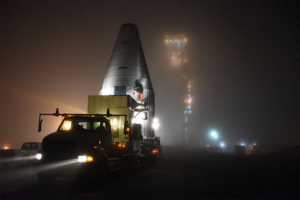
The WorldView-4 satellite, mounted inside a protective nose cone fairing, is hauled to a foggy Vandenberg Air Force Base, Calif., launch pad on Sept. 7 to await liftoff Friday.
About the size of an SUV, WorldView-4 is capable of imaging 262,000 square miles per day, storing up to 3.2 terabytes of data on board for transmission to ground stations around the world.
“It’s a huge amount of data,” Tarr said.
“Moving the data around the globe is non trivial. We’re storing a lot of imagery on the satellites, we’re moving it down about every 22 minutes, because approximately every 22 minutes the satellite is over one of our ground stations somewhere in the world.
“We then move (the data) to Colorado where we process it, and then we move it back out to our customers wherever they are in the world. And we do that in timeframes that are between 11 minutes and two hours.”
How big is WorldView-4? Big. About the size of the Chevy Suburban, excluding the solar arrays.
But why is it so big?
The satellite’s telescope accounts for more than two thirds of its total size.
While modern electronics have decreased the size and cost of satellite components like onboard processors, radios, and digital storage, there is no way to reduce the size of the telescope without degrading the resolution of its images, simply due to the laws of physics.
WorldView-4 was originally built for GeoEye Inc., which had planned to launch it in 2014.
But after the merger of GeoEye and DigitalGlobe in 2013, the fully assembled, tested and renamed satellite was put into storage.
Tarr said increasing demand, prompted in part by the easing of government restrictions on commercial space imagery resolution, prompted a decision to get WorldView-4 into orbit as soon as possible.
“There was a significant change to the regulations about two years ago that relaxed what are called resolution restrictions from 50-centimeter (19.7-inch) imagery to 25-centimeter (9.8-inch) imagery. So that freed us up to make the full capabilities of WorldView-3 and soon, WorldView-4, available to customers.”
He said the relaxed restrictions on resolution allowed WorldView-3 “to bring to market for the first time this ultra-high-resolution imagery.”
“And what we found is that there is a demand out there that we’ve been unable to meet with just WorldView-3, especially over the most volatile parts of the world,” Tarr said. “We lined up a group of customers ... to purchase the capacity of WorldView-4.”
He said DigitalGlobe also is working to develop and launch a fleet of smaller satellites starting around the end of 2018 “that will enhance our capabilities by allowing us to essentially image areas of interest on the globe with more frequency. ... They’ll see something on the ground, might not be able to quite make out what it is, but then we’ll zoom in with our higher-resolutions satellites and image more closely.”
“If it turns out to be something we want to track frequently, then we’ll use the entire constellation, including the small satellites and the higher-resolution satellites, to monitor and track whatever that object or area of interest is.”
Digital Globe archive visualization
The earth’s surface area is roughly 510 million square kilometers.
The DigitalGlobe constellation can collect 4 million square kilometers every day, which means that it could theoretically image the earth’s entire surface in about four months.
But how much of that area is of interest to customers?
First, let’s rule out the largely empty oceans and seas, which cover 71% of the surface of the earth, and also Antarctica (interesting for penguins but not so much for people), leaving about 150 million square kilometers of land.
Next, let’s exclude the 60% or so of earth’s landmass that is covered by clouds on any given day.
Now we’re down to about 60 million square kilometers of cloud-free, observable land area.
If we consider that 95% of the world’s population lives on just 10% of the earth’s landmass, then we can infer that a great proportion of the most interesting activities on earth are actually taking place on a tiny sliver of its surface.
WorldView-4 has an expected lifetime of about 10 years.
Tarr said DigitalGlobe is in the early phases of designing a next-generation system that will enable much more rapid revisits to areas of interest.
In 2015, Defense and security company Saab and DigitalGlobe Inc., a leading global provider of high-resolution earth imagery solutions, launch the joint venture – Vricon Inc. – to produce photo-realistic 3D products and digital elevation models globally for enterprise and government geospatial markets with unmatched coverage and delivery timelines.
“In our business, time can mean life or death for customers,” Tarr said.
“We’re talking about intelligence, we’re talking about defense, we’re talking about supporting first responders, supporting law enforcement. Time really does matter.”
Map showing the search routes for Sir John Franklin's lost (and recently found) ships.
The
larger, more southern blue circle indicates the area that Erebus was
found, whereas the smaller more northern blue circle indicates the area
that the Terror has allegedly been found.
The long-lost ship of British polar explorer Sir John Franklin, HMS
Terror, has been found in pristine condition at the bottom of an Arctic
bay, researchers have said, in a discovery that challenges the accepted
history behind one of polar exploration’s deepest mysteries.
HMS Terror and Franklin’s flagship, HMS Erebus, were abandoned in
heavy sea ice far to the north of the eventual wreck site in 1848,
during the Royal Navy explorer’s doomed attempt to complete the Northwest Passage.
All 129 men on the Franklin expedition died, in the worst disaster to
hit Britain’s Royal Navy in its long history of polar exploration.
Search parties continued to look for the ships for 11 years after they
disappeared, but found no trace, and the fate of the missing men
remained an enigma that tantalised generations of historians,
archaeologists and adventurers.
The HMS Terror, a long 168 years lost British Ship, was found in pristine condition
under 80 feet of water by the Arctic Research Foundation.
Now that mystery seems to have been solved by a combination of
intrepid exploration – and an improbable tip from an Inuk crewmember.
On Sunday, a team from the charitable Arctic Research Foundation
manoeuvred a small, remotely operated vehicle through an open hatch and
into the ship to capture stunning images that give insight into life
aboard the vessel close to 170 years ago.
“We have successfully entered the mess hall, worked our way into a
few cabins and found the food storage room with plates and one can on
the shelves,” Adrian Schimnowski, the foundation’s operations director,
told the Guardian by email from the research vessel Martin Bergmann.
“We spotted two wine bottles, tables and empty shelving. Found a desk
with open drawers with something in the back corner of the drawer.”
Nautical CHS charts coverage quite poor in the area (GeoGarage platform)
The well-preserved wreck matches the Terror in several key aspects,
but it lies 60 miles (96km) south of where experts have long believed
the ship was crushed by ice, and the discovery may force historians to
rewrite a chapter in the history of exploration.
The 10-member Bergmann crew found the massive shipwreck, with her
three masts broken but still standing, almost all hatches closed and
everything stowed, in the middle of King William Island’s uncharted
Terror Bay on 3 September.
After finding nothing in an early morning search, the research vessel
was leaving the bay when a grainy digital silhouette emerged from the
depths on the sounder display on the bridge of the Bergmann.
“Everyone was up in the wheelhouse by that point in awe, really,”
said Daniel McIsaac, 23, who was at the helm when the research vessel
steamed straight over the sunken wreck.
Since, then, the discovery team has spent more than a week quietly
gathering images of the vessel and comparing them with the Terror’s 19th
century builders’ plans, which match key elements of the sunken vessel.
At first, the Terror seemed to be listing at about 45 degrees to
starboard on the seabed. But on the third dive with a remotely operated
vehicle, “we noticed the wreck is sitting level on the sea bed floor not
at a list - which means the boat sank gently to the bottom,”
Schimnowski said Monday.
About 24 metres (80ft) down, the wreck is in perfect condition, with
metal sheeting that reinforced the hull against sea ice clearly visible
amid swaying kelp.
A long, heavy rope line running through a hole in the ship’s deck
suggests an anchor line may have been deployed before the Terror went
down.
HMS Erebus and HMS Terror: The Tragedy of the Franklin Arctic Expedition May 19th 1845: Under the command of Rear Admiral Sir John Franklin, the largest and most well equiped Arctic Expedition of it's time set out in search of a prize that had claimed the lives of countless others before: The Legendary Northwest Passage, a trade route around the frozen wastes of the North American Arctic. Equipped with the latest charts, equipment 3 years worth of provisions, packed within tinned food cans, and 129 Officers, Sailors and Royal Marines from the Woolwich Division's Light Infantry, few doubted the expedition would be a success and for those who set out it was to be the adventure of a lifetime, another triumph of British Science over nature. Yet as the HMS Erebus and HMS Terror entered the frozen wastes of the Arctic, what was to be a great adventure became a living nightmare when the Erebus and Terror became trapped in the ice off King William Island and the men soon discovered their 3 years worth of food had become poisoned by lead from the cans it was kept in. For nearly a decade the trapped men would slowly succumbed to the toxic food, disease, starvation, madness, the elements and desperate attempts to reach safety. By the time rescuers found their camps, the Erebus and Terror had vansihed and scattered across the frozen Arctic wastes 130 Officers, Sailors, and Royal Marines, including Sir John Franklin, lay dead, silent reminders that overconfidence in technology will always end in disaster
If true, that sets up the tantalising possibility that British
sailors re-manned the vessel after she was abandoned at the top of
Victoria Strait in a desperate attempt to escape south.
One crucial detail in the identification of the ship is a wide exhaust pipe rising above the outer deck.
It is in the precise location where a smokestack rose from the
locomotive engine which was installed in the Terror’s belly to power the
ship’s propeller through closing sea ice, said Schimnowski in a phone
interview.
The ship’s bell lies on its side on the deck, close to where the sailor on watch would have have swung the clapper to mark time.
And the majestic bowsprit, six metres (20ft) long, still points
straight out from the bow as it did when the crew tried to navigate
through treacherous ice that eventually trapped Erebus and Terror on 12
September 1846.
The wreck is in such good condition that glass panes are still in
three of four tall windows in the stern cabin where the ship’s
commander, Captain Francis Crozier, slept and worked, Schimnowski added.
“This vessel looks like it was buttoned down tight for winter and it
sank,” he said.
“Everything was shut. Even the windows are still intact.
If you could lift this boat out of the water, and pump the water out,
it would probably float.”
A chart illustrative of the cruise of the American Arctic expedition in search of sir John Franklin in the years 1850 & 51 fitted out by Henry Gunnell ... commanded by E.J. De Haven ... /
compiled by P.M. Geo. P. Welsh ... under the direction of M.F. Maury ... from materials in the Bureau of Ordnance and Hydrography
Welsh, George P.; Maury, M.F. (1806-1873)
Scale ca. 1:5.000.000
Publisher: Washington, United States Hydrographical Office
The Arctic Research Foundation was set up by Jim Balsillie, a
Canadian tech tycoon and philanthropist, who co-founded Research in
Motion, creator of the Blackberry.
Balsillie, who also played a key role in planning the expedition,
proposed a theory to explain why it seems both Terror and Erebus sank
far south of where they were first abandoned.
“This discovery changes history,” he told the Guardian.
“Given the
location of the find [in Terror Bay] and the state of the wreck, it’s
almost certain that HMS Terror was operationally closed down by the
remaining crew who then re-boarded HMS Erebus and sailed south where
they met their ultimate tragic fate.”
The 21st-century search for Franklin’s expedition was launched by
Canadian former prime minister Stephen Harper as part of a broader plan
to assert Canadian sovereignty in the Arctic and promote development of
its resources – including vast reserves of oil and natural gas, which
will be easier to exploit as the Arctic warms and sea ice disappears.
Parks Canada
underwater archeologists have led the mission since it began in 2008.
Now they must confirm the wreck is Terror, either by examining the
foundation’s images or visiting the site themselves.
With the first
winter snow already falling in the High Arctic, Terror Bay will soon be
encased in thick sea ice.
The latest discovery was made two years and a day after Canadian marine archeologists found the wreck of Erebus in the same area of eastern Queen Maud gulf where Inuit oral history had long said a large wooden ship sank.
The same stories described startled Inuit stumbling upon a large dead
man in a dark room on the vessel, with a big smile.
Experts have
suggested that may have been a rictus smile, or evidence that the man
had suffered from scurvy.
Parks Canada archeologists found Erebus standing in just 11 meters of
ocean.
Sea ice had taken a large bite out her stern, and more than a
century of storm-driven waves had scattered a trove of artifacts around
the site.
So far, archaeologists have brought up the bell from Franklin’s flagship, a cannon, ceramic plate and other objects.
Inuit knowledge was also central to finding the Terror Bay wreck, but
in a more mysterious way. Crewman Sammy Kogvik, 49, of Gjoa Haven, had
been on the Bergmann for only a day when, chatting with Schimnowski on
the bridge, he told a bizarre story.
About six years ago, Kogvik said, he and a hunting buddy were headed
on snowmobiles to fish in a lake when they spotted a large piece of
wood, which looked like a mast, sticking out of the sea ice covering
Terror Bay.
In a phone interview, Kogvik said he stopped that day to get a few
snapshots of himself hugging the wooden object, only to discover when he
got home that the camera had fallen out his pocket.
Kogvik resolved to keep the encounter secret, fearing the missing
camera was an omen of bad spirits, which generations of Inuit have
believed began to wander King William Island after Franklin and his men
perished.
When Schimnowski heard Kogvik’s story, he didn’t dismiss it, as Inuit
testimony has been so often during the long search for Franklin’s
ships.
Instead, the Bergmann’s crew agreed to make a detour for Terror Bay
on their way to join the main search group aboard the Canadian Coast
Guard icebreaker CCGS Sir Wilfrid Laurier and the Royal Canadian Navy’s
HMCS Shawinigan, at the north end of Victoria Strait.
That is where the only known record of the Franklin expedition
provided coordinates for what experts now call the point of abandonment.
A scrawled note dated 25 April 1848, and concealed in a stone cairn
at Victory Point on northern King William Island, said Erebus and Terror
had been abandoned three days earlier, stuck in sea ice.
Crozier was in command of “the officers and crews, consisting of 105
souls”, because Franklin had died on 11 June 1847, the note continued,
“and the total loss by deaths in the expedition has been to this date 9
officers and 15 men”.
Crozier and Captain James Fitzjames signed the note, which had what
seemed a hurried postscript, scrawled upside down in the top right
corner: “and start on to-morrow 26th for Back’s Fish River”.
Survivors apparently hoped to follow the river – now known as Back
river – south to safety at a Hudson’s Bay Company fur trading outpost.
None made it, and for generations, the accepted historical narrative
has described a brutal death march as the Royal Navy mariners tried to
walk out of the Arctic, dying along the way.
Now Franklin experts will have to debate whether at least some of the
dying sailors instead mustered incredible strength, fighting off
hunger, disease and frostbite, in a desperate attempt to sail home.
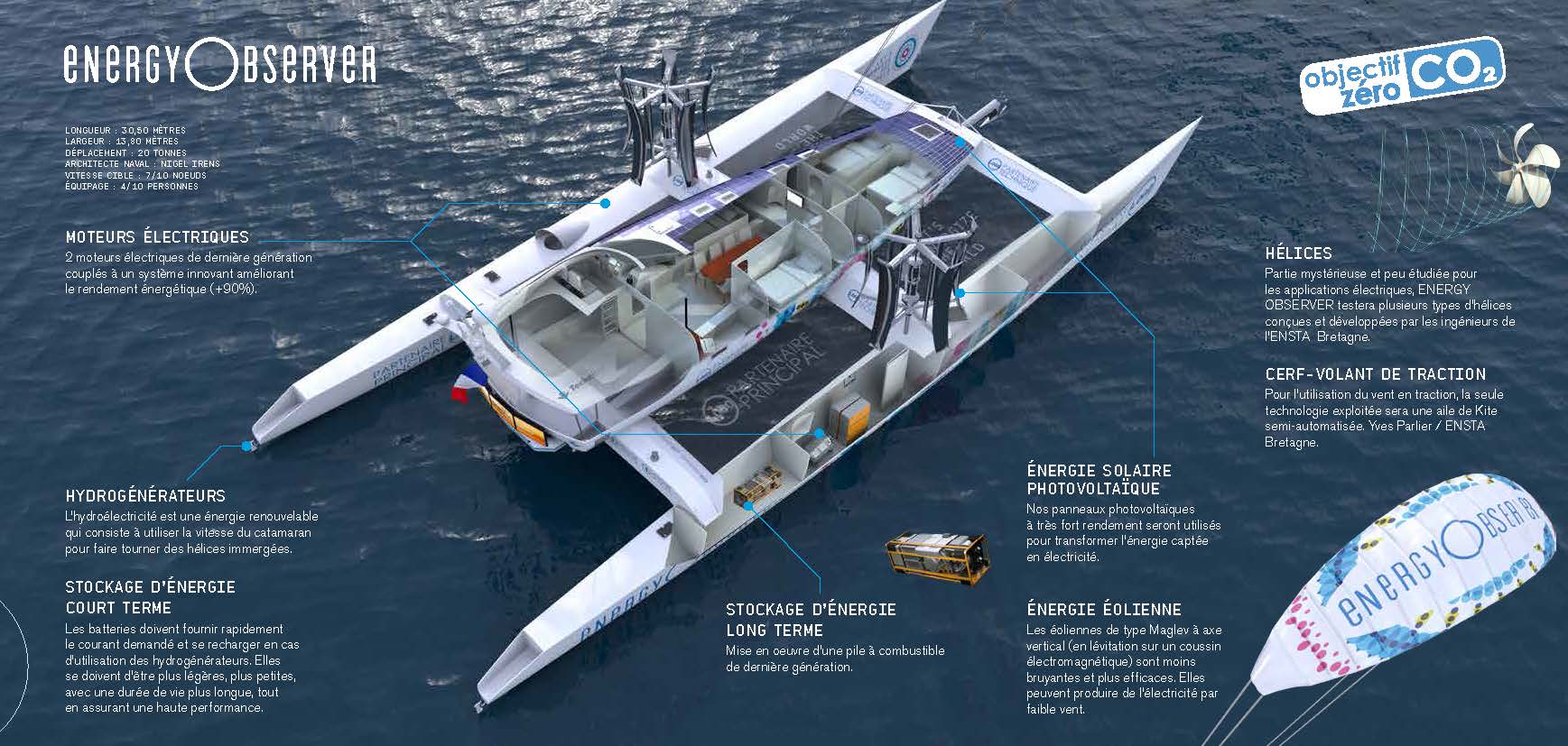
Vessel aiming to be the ‘Solar Impulse of the seas’ will be powered
solely by renewable energies and hydrogen during its six-year voyage
Dubbed the “Solar Impulse of the seas”, the first boat to be powered
solely by renewable energies and hydrogen hopes to make its own historic
trip around the world.
The multi-hulled catamaran is in a shipyard at Saint Malo on France’s
west coast, awaiting the installation of solar panels, wind turbines
and electrolysis equipment, which breaks down water to produce its
component elements, hydrogen and oxygen.
“We are going to be the first boat with an autonomous means of
producing hydrogen,” says Frenchman Victorien Erussard, who is behind
the project – confidential until now – with compatriot Jacques
Delafosse, a documentary filmmaker and professional scuba diver.
The plan is for the boat’s batteries, which will feed the electric
motors, to be powered in good weather by solar and wind energy,
explained the 37-year-old merchant navy officer.
“If there’s no sun or wind, or if it’s night, stored hydrogen –
generated by electrolysis powered by the solar panels and two wind
turbines – will take over,” he said.
As a result, the vessel’s trip will not use any carbon-emitting fossil fuels, as is the case for 96% of boats today.
An artist’s impression of the Energy Observer.
Photograph: PR Company Handout
The vessel itself has a storied past.
The catamaran won the Jules Verne trophy for a team sailing non-stop
round the world, in 1994.
It was bought for €500,000 ($562,000) and
extended by a whopping six metres, to 30.5 metres (100 feet), for the
project.
Formule Tag (Mike Brich) then Enza (Peter Blake) past lives of 'Energy Explorer'
One of the backers of the endeavour is well-known French environmentalist Nicolas Hulot.
“I support it because it’s the first project of this kind to actually
be undertaken, it’s ambitious and looking toward the future,” Hulot, a
former special envoy on environmental protection to President François
Hollande, told AFP.
“It’s very promising for marine transport,” Hulot added.
“The Energy
Observer is going to demonstrate that you can have great autonomy (at
sea) and you can store and find energy when there isn’t any more wind or
sun.”
The Energy
Observer was designed in partnership with a team of naval architects
and the CEA-Liten research institute in the French city of Grenoble,
which is dedicated to renewable energy technologies.
At a total cost of €4.2m ($4.72m), the green energy boat will be
fitted with sensors to act as veritable moving laboratory for CEA-Liten,
whose director Florence Lambert describes the project as a “great
challenge”.
“Energy Observer is emblematic of what will be the energy networks of
tomorrow, with solutions that could even be used within five years,”
said Lambert.
“For example, the houses of tomorrow could incorporate a system of
hydrogen storage, which is produced during the summer months and then
used in the winter.”
The head of the project at CEA-Liten, Didier Bouix, adds that
hydrogen can store “20 times more energy” than conventional batteries.
Energy Observer’s world tour is expected to take six years.
After a
careful crossing of the Mediterranean, the catamaran will venture out
into the Atlantic and then Pacific oceans.
In all, 101 stopovers are planned from Cuba to New Caledonia to Goa on India’s west coast.
There are still hurdles to overcome, not least in funding: the Energy
Observer’s trip is expected to cost a minimum of €4m a year, notably to
develop a traveling exhibition.
But the team said it is confident of getting the funds.
And once again it finds inspiration from its airplane mentor Solar
Impulse – which flew around the world on renewable energy and
accomplished “what everyone said was impossible,” said Delafosse.
The "Ocean Observatories Initiative" is an National Science Foundation Division of Ocean Sciences program that focuses the science, technology, education and outreach of an emerging network of science driven ocean observing systems.
It is a networked infrastructure of science-driven sensor systems to measure the physical, chemical, geological and biological variables in the ocean and seafloor as well as the overlying atmosphere, providing a fully integrated system collecting data on coastal, regional and global scales. The Ocean Observatories Initiative is a project funded by the National Science Foundation.
It is a networked infrastructure of science-driven sensor systems to measure the physical, chemical, geological and biological variables in the ocean and seafloor as well as the overlying atmosphere, providing a fully integrated system collecting data on coastal, regional and global scales. The goal of the OOI is to deliver data and data products for a 25-year-plus time period within an expandable architecture that can meet emerging technical advances in ocean science.
These data are freely accessible online through the OOi Cyberinfrastructure. Construction of the OOI commenced in 2009.
Initial installations of scientific instrumentation began in summer 2013, and the project was to be in full operation by early 2015. The OOI project builds on the heritage of the ship-based expeditions of the last century and the more recent emphasis to increase ocean observation and in situ monitoring.
Over the summer, while the rest of us were getting tan (via lasers, of
course, as is PopSci’s style), the National Science Foundation’s R/V
Sikuliaq took a 39-day Vision 16 cruise.
It wasn’t exactly a typical cruise.
Rather than kicking back, the crew was busy surveying the cables that
feed a network of observatories collecting open-access marine and
climate data, called the Ocean Observatory Initiative--the newest chess
piece in the NSF’s campaign to stitch together a massive data collection
network.
Harvard biologist Peter Girguis assures PopSci that “Let’s put [an
array of sensors] on the seafloor and see what it can do” was part of
the thought process guiding the NSF’s move to deploy the multi-million dollar network of autonomous lab equipment and underwater vehicles.
Sadly, it was not the sole motivation behind it.
After all, it took $386 million and a nearly a decade of development, but finally up and running, the OOI is “the largest fixed oceanographic observatory in the world,” according to director Greg Ulses.
Translation: by size, scale, and terabytes, this set-it-and-forget-it
web of fixed lab equipment dwarfs any other system collecting data on
the ocean.
Drawing from a network of 830 instruments on 83 platforms
across seven different sites, the OOI digitizes the oceans in real-time,
into a data stream on everything from pH to temperature, accessible to
anyone, from anywhere.
And less than two months into its debut, the Vision 16 cruise put in
some upgrades to the system, the equivalent of a periodic cell phone
update.
The system’s instruments and cables are all modular, designed to
be regularly swapped for new hardware.
But, minus requiring a cruise
ship full of engineers to hack out the old components and drop in the
new, as part of a plan to expand the platform’s technology over the next
25 years, it’s practically the same as a cellphone update.
Nonetheless, the OOI is back up in full force, and addressing what
Girguis believes is a fundamental challenge of oceanography--one that
makes the cruise’s name oddly appropriate: visibility.
While drones and hyperspectral satellites can easily monitor events
on land, even an ultralight beam starts scattering 50 meters into the
electromagnetically opaque ocean, preventing scientists from getting a
clear picture.
Similarly, the glut of oceanic data we already have is
largely scattered and unorganized, so marine scientists have to overcome
both a literal and figurative lack of visibility.
“The OOI, and all
these other various” oceanic mapping programs, are a pretty big deal for
many ocean researchers. They produce far more data than is usually
published, and can “stitch it together in such a way that a new
generation of scientists can look at it with their fresh,
computationally savvy eyes,” said Girguis.
AUV by Yann Lepage (Underwater pictures)
The “all these other various programs” bit is where things get exciting.
For several years, the international community has been working under
an joint initiative spearheaded by US and EU, called COOP+.
Piloted by
the NSF, on the American end, its mandate is to expand the Global Earth
Observation System of Systems or GEOSS:
a massive web of open-access networks that bring Big Earth Data to
scientists, courtesy of arrays of sensory equipment.
Alongside other
international programs, and the massive DataONE database fed by them
all--the OOI is just one (albeit particularly large) data source among
the many that the NSF is campaigning to combine.
But the best insight into the scale and precariousness of this
behind-the-scenes chess game comes from NEON, or the National Ecological
Observatory Network, which will function as a cousin to the OOI when it
launches in 2018.
Through eighty-one field sites, a National Oceanic
and Atmospheric Administration data center, and partnerships with dozens
of universities, NEON will collect air, sea, and land data in real
time. However, the program’s development hasn’t exactly been smooth.
Prior to recent management changes, it suffered delays, more than a few mishaps
with a $469 million budget, and subsequently, a fair share of
opposition from both budget-minded Republican House committee members,
and from within the oceanographic community.
Once online, though, NEON will be simply one of thirty-one
data suppliers for DataONE, which itself is just one particularly large
repository fed mostly with information from the U.S. and the E.U, all
buried within an international web that’s effectively turning the entire
Earth into 0’s and 1’s.
So, next time you’re on a cruise, kicking back with a copy of PopSci
and getting the latest on the fight to research climate change and study
ocean wildlife, remember--on their cruise, a bunch of engineers built a
digital Eye of Sauron that’s powering that fight...and tracking your
ship’s carbon footprint.
Denmark, Andrea Leadsom suggested, might have reason to be thankful to the UK.
As the then-energy minister reminded MPs in April, the Scandinavian country is recipient of “the bill-payer subsidy for the most prolific offshore wind installer in the world”.
“The UK has 50pc of the world’s offshore wind and the Danish developers have benefited enormously,” she said.
A turbine being installed at Dong Energy's Burbo Bank Extension project
credit MHI Vestas
The installer in question was Dong Energy.
Majority-owned by the government of Denmark, the oil and gas company-turned-offshore wind developer has conquered the seas around Britain in unrivalled fashion
And, as Leadsom’s comments hinted, there is some unease at the spoils of this new Viking invasion.
The London Array offshore wind farm,
one of the eight existing projects in which Dong Energy has a stake
credit : Emily Gosden
From its modest start with the 90 megawatt (MW) Barrow offshore wind farm, one of the UK’s first when it was completed in 2006, Dong has built an empire encompassing ownership or part-ownership of eight projects in UK waters.
They include a 25pc stake in the 175-turbine London Array, which, at 630MW, is the biggest offshore wind farm in the world to date.
In total, of the 5.1 gigawatts (GW) of turbines installed in the UK waters, Dong has interests in just over two-fifths (2.2GW) of them; its actual ownership stakes equate to 985MW.
Everything it has built to date receives subsidies through the Renewables Obligation (RO) scheme; analysis of Ofgem data suggests Dong’s share of the subsidies last year, on top of the wholesale electricity price, could easily have topped £250m.
source : DONG Energy Corporate
And that’s just the start.
Dong is currently constructing four more offshore wind farms.
There is the Burbo Bank Extension (258MW), where the world’s largest turbine, an 8MW beast taller than the Gherkin, was installed last week.
Then there is Race Bank (570MW), the Walney Extension (659MW) and Hornsea One, which, at 1.2GW, should seize the crown of the biggest in the world when completed in 2020.
The first new 8MW turbine being installed in UK waters
credit : MHI Vestas
Of the 10GW of turbines the Government expects to be spinning in UK waters by the end of this decade, Dong Energy is due to be involved in almost exactly half.
The company says its new investment will total £6bn, on top of £6bn spent in the UK to date.
And with eye-watering investment figures, come even more eye-watering subsidies.
Aside from Race Bank, which qualifies for the RO, the other three under construction were awarded subsidies in April 2014 under the Government’s new 'contracts for difference’ scheme, guaranteeing them a fixed price for the electricity they generate for 15 years.
For Burbo Bank and Walney, the contract price is £150 per megawatt-hour (MWh) or about three and a half times the current wholesale power price; for Hornsea, a marginally cheaper £140/MWh.
Government estimates obtained by the Telegraph suggest that when these three projects start generating they will receive subsidies, over and above the wholesale power price, of £880m a year. Over their lifetime, even on a discounted basis, the payments will be worth a cool £7.6bn.
Dong Energy UK wind farm interests
To understand how Dong Energy built such a dominant position, you have to go back a decade, to when it was formed through the merger of the original Danish Oil & Natural Gas company with five electricity-focused Danish energy companies to form a national champion.
“The Danish Government had very much said, 'we are massively reliant on imported coal and oil and gas’. They wanted to minimise that,” explains Brent Cheshire, Dong Energy’s UK country chairman.
“Dong was state-owned so their mind-set was: we are moving into wind, wind is going to be the big thing.”
The company set about transforming itself from one focused on fossil fuels to one focused on wind.
And as it did so, it spied opportunity across the North Sea, where the UK Government had also thrown itself behind offshore wind in pursuit of climate change targets.
“The Dong management team said, the UK has potentially got much more opportunity in similar geographical conditions. So we have a mousetrap sitting here in Denmark that we can export,” Cheshire says.
Dong Energy has installed turbines in Danish waters but also saw it as an export opportunity
credit : Dong Energy
John Musk, utilities analyst at RBC Capital Markets, also believes that Dong Energy’s state-controlled ownership structure was key.
“During the time when other utilities largely had been constrained in terms of the amount of capex they were able to put to work and were cutting back on projects, the Danish government was able to look at longer term and pursue the offshore wind strategy,” he says.
“They were more focused on this than others. For Dong, offshore wind was their raison d’être.”
Horns 1 & 2 wind farm in Denmark with the GeoGarage platform (DGA nautical chart)
It was with the awarding of the first round of the new renewable subsidy contracts in 2014 that Dong’s UK dominance really started to be noticed, as the developer of three of the five offshore wind projects to win Government backing.
The deals have since proved highly controversial: the National Audit Office found that the prices for the subsidies, set administratively by the Government, were likely to have been unnecessarily high.
Less than a year after they were handed out, a competitive auction to award subsidies for further offshore wind appeared to prove the point, with rival developers securing contracts to build offshore wind projects for less than £120/MWh, some 15pc-20pc below the prices awarded to Dong.
“They [Dong’s contracts] were way too high. They were too generous, absolutely,” says one rival industry executive.
“If the Government had run an auction there and then, it would have come up with a much lower number.”
Dong executives are at pains to deny this.
“At the time we got the [contracts], our competitors said the prices were unrealistically low,” says Cheshire. “I had personal phone calls where I was berated for destroying the market.”
“Everybody was saying, no one will build at these prices, it’s the end of the industry,” insists Samuel Leupold, Dong Energy’s vice-president for wind power.
How the latest turbines stack up against London's tallest buildings
Dong’s commitment to offshore wind, he suggests, enabled it to see the potential – and the need – for cost reduction where others didn’t.
Even then, he insists, it still regarded those prices as “a challenge”.
“We worked extremely hard. We put our neck on the block and said, we fully agree with the Government in accusing offshore wind of being too expensive. It was blood, sweat and tears to bring the cost down,” he says.
“I think I have the arrogance to say that the rest of the industry was over-promising and under-delivering. We knew that, given we were so much betting on offshore wind, we needed to deliver.”
One of the key ways of delivering lower costs has been through continual moves to bigger, more powerful turbines, culminating in those 8MW turbines at Burbo Bank.
“We have bet on technology and we have taken the risks of being the first implementer,” says Cheshire.
He insists that the award of the 2014 contracts enabled the industry cost-reduction that followed, giving the supply chain a pipeline of projects and enabling economic of scale.
Despite Dong’s protestations, many share the belief that Dong got a very good deal on its three contracts.
“I think they are certainly going to be getting attractive returns, and they are likely to be higher than the returns they would be able to win today,” says Musk of RBC, who initiated coverage this summer after Dong’s IPO, which valued the company at £10bn.
The perception that the contracts were generous has only grown after Dong agreed a contract for a wind farm in the Netherlands in July, that will be up and running around the same time as Hornsea One, with a subsidy contract at just €72.70/MWh.
While Dong stresses this is not comparable with its £140/MWh at Hornsea for a number of reasons – not least as it excludes €20-30/MWh in transmission costs – it is clearly still substantially cheaper.
“The question now for the Government,” says the rival wind executive, “is: you are where you are, we work on the assumption no-one’s about to rip the contracts up, so how do you get the best value out of those contracts? Anybody sitting with a contract at £150/MWh should be getting pushed really bloody hard to get investment in the UK and to buy supply from UK-based organisations.”
The Government had set a target of 50pc UK content in offshore wind, which Leupold says is “realistic” for its next projects.
London array
credit : Bloomberg
Leadsom as energy minister was vocal in calling for developers who secured the early contracts to maximise the benefits to the UK, calling it “payback time”.
With energy now paired with industrial strategy in a department, it seems likely her successors will also have a keen eye on UK content.
Leupold issues a warning shot on this front
“The idea that every country gets a vertically-integrated industry that produces all the parts of the turbines in that country itself, that is what politicians dream of,” he says.
“But everybody understands that, since every country dreams of that, you’d basically build up the industry five times around the North Sea, and that is of course the contrary of becoming cost-efficient. So the reality is you split up the scope and say you have different hubs where you specialise in a certain discipline.”
London Array Wind Farm, April 17, 2016 (Planet Labs)
For the projects now under construction, the blades will be made in the UK: either by Siemens in Hull, or MHI Vestas in the Isle of Wight.
Some foundations may come from Teesside, but many turbine parts will be produced elsewhere. The Siemens nacelles come from Germany, while towers are likely to be sourced across Europe.
“The tower is a commodity, everybody can make towers. The blade, believe me, the blade is the frontier, technology wise,” Leupold says.
Britain may have to accept parts made in Germany but, he says, “our next German project will use blades made in the Isle of Wight.”
Whatever battles lie ahead over the supply chain, the new Government has already reaffirmed plans to continue the UK’s drive for offshore wind.
More subsidies are due to be awarded this parliament, subject to cost-reduction targets that Dong says it is confident it can meet.
And that means Dong’s conquest of the North Sea is not over yet.
Last month it got planning consent for Hornsea Two, which at 1.8GW is the biggest to have got permission anywhere in the world.
Musk says he “fully expects” Dong to secure subsidies for the construction of at least part the project in the next auction, due early next year.
Plans for Hornsea Three, at up to 2.4GW, are already being drawn up; there is talk that a Four and Five could follow.
Dong’s position as the market leader looks safe “for the forseeable future”, Musk concludes.
“It’s unlikely they will be superseded by anyone else.”
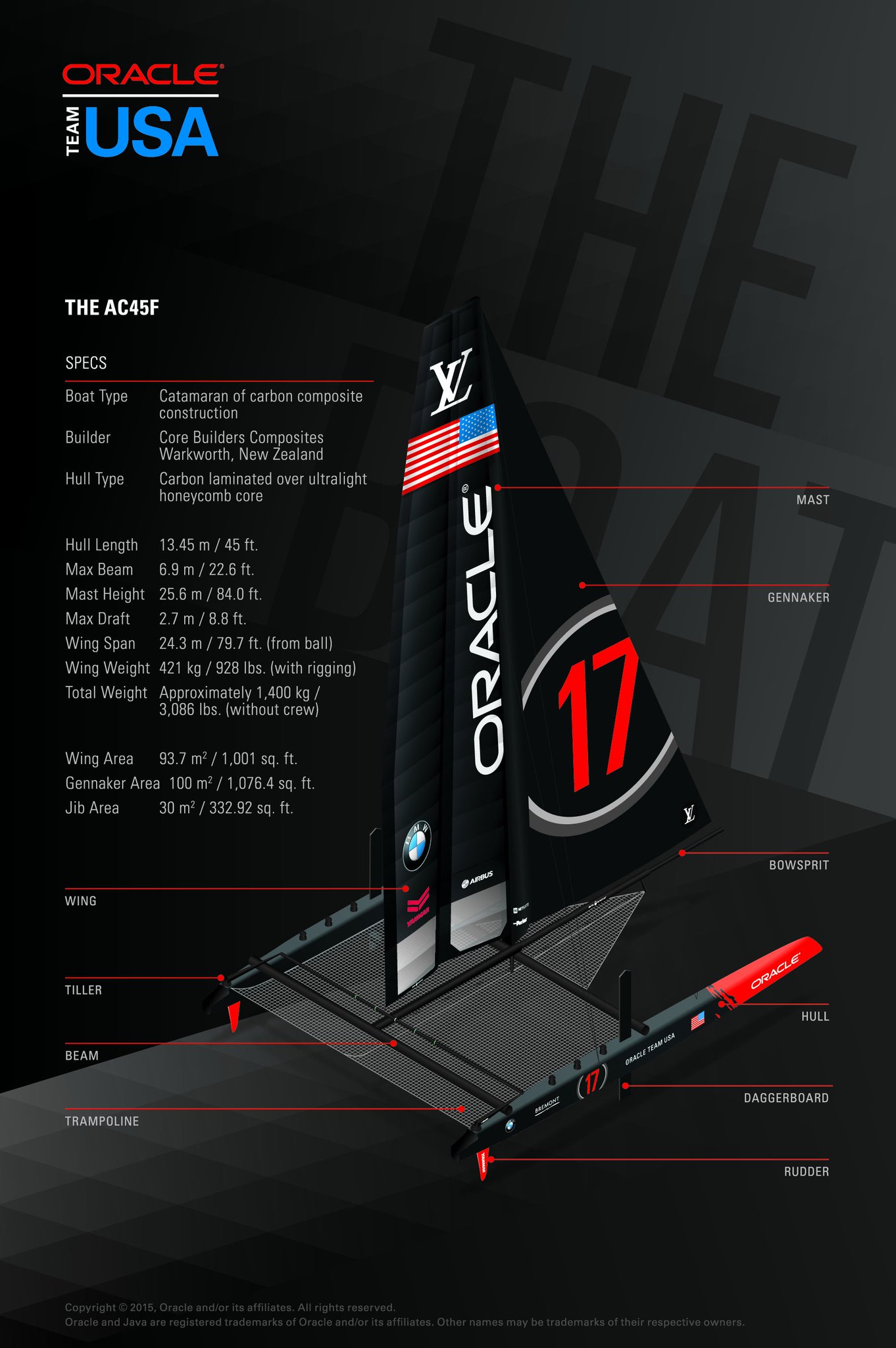
Now it can be told! The foiling tack is a game-changer.
SoftBank Team Japan and then ORACLE TEAM USA, started foil-tacking upwind back in April.
Earlier this summer, ORACLE TEAM USA, added the move to its repertoire when sailing in full manual-mode, and now the race is on to get around the race course without coming down off the foils.
"It’s very likely that the boat that can make it around the racecourse without touching the water will win this America’s Cup," said tactician/sailing team manager Tom Slingsby.


