Saturday, March 22, 2014

Dakuwaqa's Garden - Underwater footage from Fiji & Tonga

Underwater footage shot whilst scuba diving in the Fiji islands and Tonga.
Featuring colorful coral reefs, huge schools of tropical fish, sharks, humpback whales, underwater caves, scuba divers and much more marine life from the south Pacific.

Friday, March 21, 2014

Seeing equinoxes and solstices from space

The four changes of the seasons, related to the position of sunlight on the planet, are captured in this view from Earth orbit.

From NASA

One of the most frequently misunderstood concepts in science is the reason for Earth’s seasons.
As we experience the September equinox today—anyone try to balance an egg yet?—we thought we’d offer a space-based view of what’s going on.
Around 6 a.m. local time each day, the Sun, Earth, and any geosynchronous satellite form a right angle, affording a nadir (straight down) view of the terminator, the edge between the shadows of nightfall and the sunlight of dusk and dawn.
The shape of this line between night and day varies with the seasons, which means different lengths of days and differing amounts of warming sunshine.
(The line is actually a curve because the Earth is round, but satellite images only show it in two-dimensions.)
The Spinning Enhanced Visible and Infrared Imager (SEVIRI) on EUMETSAT's Meteosat-9 captured these four views of Earth from geosynchronous orbit.

 acquired December 21, 2010 - September 20, 2011

acquired December 21, 2010 download large winter solstice image (1 MB, JPEG, 3712x3712)
acquired March 20, 2011 download large spring equinox image (1 MB, JPEG, 3712x3712)
acquired June 21, 2011 download large summer solstice image (1 MB, JPEG, 3712x3712)
acquired September 20, 2011 download large fall equinox image (1 MB, JPEG, 3712x3712)
acquired September 19, 2010 - September 19, 2011 download high definition animation (23 MB, QuickTime)
The images show how sunlight fell on the Earth on December 21, 2010 (upper left), and March 20 (upper right), June 21 (lower left), and September 20, 2011 (lower right).
Each image was taken at 6:12 a.m. local time.
On March 20 and September 20, the terminator is a straight north-south line, and the Sun is said to sit directly above the equator.
On December 21, the Sun resides directly over the Tropic of Capricorn when viewed from the ground, and sunlight spreads over more of the Southern Hemisphere.
On June 21, the Sun sits above the Tropic of Cancer, spreading more sunlight in the north and turning the tables on the south.

The bulge of our spherical Earth blocks sunlight from the far hemisphere at the solstices; that same curvature allows the Sun’s rays to spread over more area near the top and bottom of the globe.
Of course, it is not the Sun that is moving north or south through the seasons, but a change in the orientation and angles between the Earth and its nearest star.
The axis of the Earth is tilted 23.5 degrees relative to the Sun and the ecliptic plane.
The axis is tilted away from the Sun at the December solstice and toward the Sun at the June solstice, spreading more and less light on each hemisphere.
At the equinoxes, the tilt is at a right angle to the Sun and the light is spread evenly.
The equinox and changing of the seasons occurs on September 23, 2011 at 9:05 a.m. Universal Time. (Our September image above is a few days early.)
Equinox means "equal night" in Latin, capturing the idea that daytime and nighttime are equal lengths everywhere on the planet.
That is true of the Sun's presence above the horizon, though it does not account for twilight, when the Sun's rays extend from beyond the horizon to illuminate our gas-filled atmosphere.

Read more about the March Equinox from Date and Time

Related Reading

  1. Stern, D. (2005) From Stargazers to Starships: Seasons of the Year. Accessed September 22, 2011.
  2. U.S. Naval Observatory Day and Night Across the Earth. Accessed September 22, 2011.
  3. U.S. Naval Oceanographer Earth's Seasons. Accessed September 22, 2011.

Thursday, March 20, 2014

Has the time come for floating cities?

Koen Olthuis (1971) "the Floating Dutchman" studied Architecture and Industrial Design at the Delft University of Technology.
In 2007 he was chosen as nr. 122 on the Time Magazine list of most influential people in the world due to the worldwide interest in water developments.
The French magazine Terra Eco chooses him as one of the 100 green persons that will change the world in 2011.
In his vision today's designers are an essential part of the climate change generation and should start to enhance their perspective on urban components to become dynamic instead of static.
His solution called City Apps, are floating urban components that add a certain function to the existing static grid of a city.
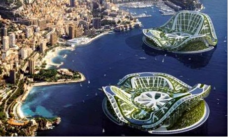
Using existing urban water as building ground offers space for new density, offering worldwide opportunities for cities to respond flexibly to climate change and urbanization.
The first city, in which this vision is being developed, is The Westland, near The Hague in Holland. This project incorporates both floating social housing, floating islands, and floating apartment buildings. In 2010, the government of the Maldives agreed to develop a floating city, floating islands, floating golf courses, floating hotels and a floating conference centre in a joint venture, as a solution to the problems caused by rising sea levels and also to encourage social and economic advancement.
A sustainable future lies beyond the waterfront!

From The Guardian by Jessa Gamble 

From schools at sea to a city that perpetually sails the oceans, is climate change creating a bold new era of floating urban design?

Until the late 1980s, nestled behind the Yan Ma Tei breakwater in Hong Kong's Causeway Bay, you could find tens of thousands of boat-dwellers who formed a bustling, floating district.
The residents were members of the Tanka community, and their ancestors were fishermen who retreated from warfare on land to live permanently in their vessels.
Until the mid-20th century, these traditional outcasts were forbidden even to step ashore.
The typhoon shelter was famous for its restaurants' cuisine – including Under Bridge Spicy Crab – and it was a nightlife hub, alive with mahjong games and hired singers.
Shops on sampan (flat boats) catered to the floating district's needs.
It may seem like science fiction, but as rising sea levels threaten low-lying nations around the world, neighbourhoods like this may become more common.
Whereas some coastal cities will double down on sea defences, others are beginning to explore a solution that welcomes approaching tides.
What if our cities themselves were to take to the seas?

Grocery store in Makoko, Lagos, Nigeria 
Grocery store in Makoko, Lagos, Nigeria. Photograph: Devesh Uba
 
A floating village at London's Royal Docks has the official nod, and Rotterdam has a Rijnhaven waterfront development experiment well under way.
Eventually, whole neighbourhoods of water-threatened land could be given over to the seas.
After decades of speculation and small-scale applications, the floating solution is finally enjoying political momentum – and serious investment.

The immediate and most numerous victims of climate change are sure to be in the developing world. In Lagos, the sprawling slum of Makoko regularly suffers floods, and its stilted houses are shored up with each new inundation.
It's under threat of razing by authorities.
The Nigerian-born architect Kunlé Adeyemi proposes a series of A-frame floating houses to replace the existing slum.
As proof of concept, his team constructed a floating school for the community.
Still, many buildings do not make a city: infrastructure remains a problem here.
One solution would be to use docking stations with centralised services, rather like hooking up a caravan to power, water and drainage lines at a campground.

You could extend an existing city like London into the water quite far before ever being seriously challenged by infrastructure issues.
But some ideas for floating life move well beyond the urban extension model.
In the 1960s, futurist Buckminster Fuller designed a floating city, Triton, for 100,000 residents, and even had his plans approved by the US Navy. UK designer Phil Pauley has updated Fuller's geodesic concept: a ring of spherical modules, his SubBiosphere2 would float in fair weather, then submerge whenever the seas became rough.

Florida architect Jacque Fresco, meanwhile, foresees a time when humans must colonise the sea, to escape land made uninhabitable by overpopulation.
He has spent his career designing cities of the future, and himself lives in a dome-shaped prototype. Fresco's floating city designs – generally gear-shaped – prescribe the use of "memory metals". Compressed into small cubes, they are easily towed out to sea, where they can be snapped back to the size of buildings.

Floating cities - Sub-Biosphere 2  
Sub-Biosphere 2 is a closed, self-sustaining underwater habitat designed by Phil Pauley 
 
Mobility among the waves lends floating communities a degree of political independence.
The Seasteading Institute, founded by Patri Friedman (grandson of Milton), proposes a series of floating villages, and claims to be in active negotiations with potential host nations that would give the villages political autonomy.
Billed as a startup incubator for political systems, the aquatic communities would serve as experiments in governance – and represent a rejection of what Seasteaders see as big government intrusion.

The Seasteading Institute proposes a series of floating villages – and claims to be in active negotiations with potential host nations.
Photograph: Seasteading Institute

In an implementation plan for these Seasteading cities [pdf], the Dutch engineering firm DeltaSync has proposed a modular building strategy.
It too would have movable parts, for gradual growth and financing, and a dynamic geography: if new friends decide to be neighbours, they could simply tow their houses together.
At first the villages would aggregate in protected waters.
Later, they would cut ties with land altogether.
That's when all the trappings of civic life would be either abandoned or reproduced in microcosm on the rafted village.
Many of the technical components of DeltaSync's plan are well-trodden territory for engineers.
Platforms and mooring systems are not so different from those required for large boats or oil rigs.
Along with reclaimed land, floating additions to city infrastructure are becoming a regular part of municipal planning.
Airports are particularly prime for floating: they essentially require a large platform that is close to the destination city without being intrusive.
As for infrastructure solutions, they range from the well-tested to the speculative.
The abundant wind available at sea could power turbines.
Ocean thermal energy conversion could harness the temperature difference between the surface and the depths – a process that also provides fresh water as a byproduct.
DeltaSync even envisions residents cultivating aquaculture in lieu of gardens, manufacturing their food requirements from nutrients found in upwellings at the edge of continental shelves.
A so-called "Blue Revolution" in aquaculture would be required for the oceans to provide this level of sustenance.
(Even without cities at sea, though, ocean harvesting may be our best hope, as land-based agriculture faces salinated soils and a critical phosphorus shortage.)

Ooffshore eco-platforms : The Stewards of the Seas

For untethered floating societies, it's not just physical infrastructure that needs to be planned out – it's the social infrastructure, too.
Floating citizens still need jobs to do; they need to do their shopping and educate their children.
When the worst happens, they need access to medical care.
A full-service floating city already exists for residents of The World, a 644-foot yacht that continuously circles the planet.
Launched in 2002, the ship contains 165 condominium spaces that sell for millions.
And it may soon be upstaged. Freedom Ship would essentially be a mile-long flat-bottomed barge with a high-rise building on top.
Weighing 3 million tonnes and with a top speed of 10 knots, the floating city would circle the globe every three years, stopping 12 miles offshore at each port for a week at a time.
High-speed ferries would connect the 40,000 residents and 20,000 crew to the mainland and bring back visitors.
"We won't just be visiting those countries," says Freedom Ship director and executive vice president Roger Gooch.
"We anticipate those countries visiting us."
Freedom Ship's size – and its $11bn price tag – gives it a credibility problem.
But Gooch has "two or three irons in the fire in Asia" to secure his team's capital for the three-year construction process.
It will be too big for any existing shipyard to build, so the ship must be constructed in pieces and – a familiar idea by now – towed out to be assembled at sea.

Floating cities - Freedom Ship 2 
Credibility problem? … the perpetually sailing Freedom Ship would have enough room for 50,000 permanent residents.
Photograph: Roger Gooch-FSI 
 
The thriving Hong Kong sampan-dwelling community of Causeway Bay was not to last.
There was no garbage or sewerage treatment system, and fire constantly threatened the wooden structures.
Breakwaters that made up the typhoon shelter also limited water circulation, leaving pollution to accumulate in the harbour.
The wastewater from the moored vessels combined with leaked sewer discharge and storm drain runoff to create unsanitary living conditions.
When Tanka families were offered public housing on land in the 1980s, most chose this option.
Now only a few traditional sampans are left, used as ferries to take tourists to their luxury yachts. Despite sewerage improvement schemes, E Coli levels remain high, and tests show alarmingly high levels of tributyltin, a toxic biocide, in the water.
If floating communities are the way of the future, we will have to learn this lesson well: we can no longer simply outrun our own refuse.
Untethering from land seems a big moment for a floating city, akin to blasting off to colonise another planet.
To reject our ancestral habitat to this degree seems like hubris.
How could a group of people survive alone among the waves?
But it is a fallacy to imagine we're self-sustaining even in our land-based communities.
Many of our essential goods arrive by tanker anyway – a sea-based location would be all the more convenient.
Far from impractical utopias, floating cities could be every bit as integrated into global society as the ones we already have on land.

Links :

Wednesday, March 19, 2014

Northeast Greenland ice loss accelerating, researchers say

 Glaciers of Greenland
According to previous measurements and aerial photographs, the northeast Greenland ice sheet margin appeared to be stable for 25 years -- until 2003.
 Around that time, a string of especially warm summers triggered increased melting and calving events, which have continued to the present day.

From Ohio State University

All margins of ice sheet now unstable—and contributing to sea level rise

An international team of scientists has discovered that the last remaining stable portion of the Greenland ice sheet is stable no more.

The finding, which will likely boost estimates of expected global sea level rise in the future, appears in the March 16 issue of the journal Nature Climate Change [DOI:10.1038/NCLIMATE2161].
The new result focuses on ice loss due to a major retreat of an outlet glacier connected to a long “river” of ice—known as an ice stream—that drains ice from the interior of the ice sheet.

 Open water in northeast Greenland, where ice loss is accelerating.
Photo by Finn Bo Madsen, courtesy of The Ohio State University.

The Zachariae ice stream retreated about 20 kilometers (12.4 miles) over the last decade, the researchers concluded.
For comparison, one of the fastest moving glaciers, the Jakobshavn ice stream in southwest Greenland, has retreated 35 kilometers (21.7 miles) over the last 150 years.
Ice streams drain ice basins, the same way the Amazon River drains the very large Amazon water basin. Zachariae is the largest ice stream in a drainage basin that covers 16 percent of the Greenland ice sheet—an area twice as large as the one drained by Jakobshavn.

Composite photograph of a GNET GPS unit implanted in the southeastern Greenland bedrock.
Image by Dana Caccamise, courtesy of Ohio State University.
This paper represents the latest finding from GNET, the GPS network in Greenland that measures ice loss by weighing the ice sheet as it presses down on the bedrock.
“Northeast Greenland is very cold. It used to be considered the last stable part of the Greenland ice sheet,” explained GNET lead investigator Michael Bevis of The Ohio State University. “This study shows that ice loss in the northeast is now accelerating. So, now it seems that all of the margins of the Greenland ice sheet are unstable.”

 This map shows major ice drainages in Greenland, along with measured ice surface velocities.
The northeast Greenland ice stream (NEGIS) now appears to be retreating as rapidly, or perhaps more rapidly, than other parts of the ice sheet, including Jakobshavn Isbræ (JI), Helheim Glacier (HG) and Kangerdlugssuaq (KG).
Catchments for those regions are outlined on the map.
(Image credit: The Ohio State University, Natural History Museum of Denmark)

Historically, Zachariae drained slowly, since it had to fight its way through a bay choked with floating ice debris.
Now that the ice is retreating, the ice barrier in the bay is reduced, allowing the glacier to speed up—and draw down the ice mass from the entire basin.
“This suggests a possible positive feedback mechanism whereby retreat of the outlet glacier, in part due to warming of the air and in part due to glacier dynamics, leads to increased dynamic loss of ice upstream. This suggests that Greenland's contribution to global sea level rise may be even higher in the future,” said Bevis, who is also the Ohio Eminent Scholar in Geodynamics and professor of earth sciences at Ohio State.

Study leader Shfaqat Abbas Khan, a senior researcher at the National Space Institute at the Technical University of Denmark, said that the finding is cause for concern.
“The fact that the mass loss of the Greenland Ice Sheet has generally increased over the last decades is well known,” Khan said, “but the increasing contribution from the northeastern part of the ice sheet is new and very surprising.”

GNET, short for “Greenland GPS Network,” uses the earth’s natural elasticity to measure the mass of the ice sheet. As previous Ohio State studies revealed, ice weighs down bedrock, and when the ice melts away, the bedrock rises measurably in response.
More than 50 GNET stations along Greenland’s coast weigh the ice sheet like a giant bathroom scale.

Khan and his colleagues combined GNET data with ice thickness measurements taken by four different satellites: the Airborne Topographic Mapper (ATM), the Ice, Cloud and Land Elevation Satellite (ICESat), and the Land, Vegetation and Ice Sensor (LVIS) from NASA; and the Environmental Satellite (ENVISAT) from the European Space Agency.

They found that the northeast Greenland ice sheet lost about 10 billion tons of ice per year from April 2003 to April 2012.
According to previous measurements and aerial photographs, the northeast Greenland ice sheet margin appeared to be stable for 25 years—until 2003.
Around that time, a string of especially warm summers triggered increased melting and calving events, which have continued to the present day.
A large calving event at the Zachariae glacier made the news in May 2013, and Khan and his team witnessed and filmed a similar event in July.

 This map shows difference from average wind speed across the Northern Hemisphere for January-February 2014. Blues indicate areas with wind speeds that were higher than the 1981-2010 average; browns indicate winds were lower than average.
In the North Atlantic, an unusually high number of hurricane-force storms have left splashes of dark blue off southeastern Greenland, Norway, Europe, and the western Mediterranean.
(Map credit: NOAA)
Increased ice flow in this region is particularly troubling, Khan said, because the northeast ice stream stretches more than 600 kilometers (about 373 miles) into the center of the ice sheet, where it connects with the heart of Greenland’s ice reservoir.
“This implies that changes at the margin can affect the mass balance deep in the center of the ice sheet. Furthermore, due to the huge size of the northeast Greenland ice stream, it has the potential of significantly changing the total mass balance of the ice sheet in the near future,” he added.
Bevis agreed: “The fact that this ice loss is associated with a major ice stream that channels ice from deep in the interior of the ice sheet does add some additional concern about what might happen.”
The Greenland ice sheet is thought to be one of the largest contributors to global sea level rise over the past 20 years, accounting for 0.5 millimeters of the current total of 3.2 millimeters of sea level rise per year.

Tuesday, March 18, 2014

Great white shark's epic ocean trek

How OCEARCH tagged and released the first great white in Florida waters, Lydia.

From BBC

A great white shark called Lydia is about to make history as the first of its species to be seen crossing from one side of the Atlantic to the other.
The satellite-tagged 4.4m-long female is currently swimming above the mid-Atlantic ridge - which marks a rough boundary line between east and west.
Lydia was first tagged off Florida as part of the Ocearch scientific project.
The shark has travelled more than 30,500km (19,000 miles) since the tracking device was attached.


Dr Gregory Skomal, senior fisheries biologist with Massachusetts Marine Fisheries, told BBC News: "No white sharks have crossed from west to east or east to west."
Lydia is now roughly 1,600km (1,000 miles) from the coasts of County Cork in Ireland and Cornwall in Britain, and nearly 4,800km (3,000 miles) from Jacksonville, Florida, where she was tagged by scientists in March 2013.


Researchers are using a hydraulic platform to tag the sharks safely - including Lydia (pictured)

Dr Skomal explained: "Although Lydia is closer to Europe than North America, she technically does not cross the Atlantic until she crosses the mid-Atlantic ridge, which she has yet to do.
"She would be the first documented white shark to cross into the eastern Atlantic."
The mere act of tagging a great white shark (Carcharodon carcharias) is a feat in itself.
The scientists have been using a custom-built 34,000kg (75,000lb) capacity hydraulic platform, operated from their research vessel the M/V Ocearch, to safely lift mature sharks so that researchers can tag and study them.

 Lydia is over the underwater mountain system known as the Mid-Atlantic ridge and is now roughly 1,600km (1,000 miles) away from the British Isles
see Ocearch shark tracker

The Ocearch project was initiated to gather data on the movements, biology and health of sharks for conservation purposes as well as for public safety and education.
Though Lydia's journey is impressive, the sharks are known for their marathon migrations of thousands of kilometres.
A great white nicknamed Nicole travelled from South Africa to Australia and back - a circuit of more than 20,000km (12,400 miles) - over a period of nine months between November 2003 and August 2004.
As for where Lydia might go next, Dr Skomal explained: "We have no idea how far she will go, but Europe, the Med, and the coast of Africa are all feasible."

Links :
  • BBC : Transatlantic great white shark 'may be pregnant'
  • Wired : Spending 15 minutes with a great white shark on a boat deck

Monday, March 17, 2014

Soft robotic fish moves like the real thing

Autonomous, self-contained soft robotic fish at MIT

From MIT news

Soft robots — which don’t just have soft exteriors but are also powered by fluid flowing through flexible channels — have become a sufficiently popular research topic that they now have their own journal, Soft Robotics.
In the first issue of that journal, out this month, MIT researchers report the first self-contained autonomous soft robot capable of rapid body motion: a “fish” that can execute an escape maneuver, convulsing its body to change direction in just a fraction of a second, or almost as quickly as a real fish can.

“We’re excited about soft robots for a variety of reasons,” says Daniela Rus, a professor of computer science and engineering, director of MIT’s Computer Science and Artificial Intelligence Laboratory, and one of the researchers who designed and built the fish.
“As robots penetrate the physical world and start interacting with people more and more, it’s much easier to make robots safe if their bodies are so wonderfully soft that there’s no danger if they whack you.”

Another reason to study soft robots, Rus says, is that “with soft machines, the whole robotic planning problem changes.”
In most robotic motion-planning systems, avoiding collisions with the environment is the highest priority.
That frequently leads to inefficient motion, because the robot has to settle for collision-free trajectories that it can find quickly.

With soft robots, collision poses little danger to either the robot or the environment.
“In some cases, it is actually advantageous for these robots to bump into the environment, because they can use these points of contact as means of getting to the destination faster,” Rus says.

But the new robotic fish was designed to explore yet a third advantage of soft robots: “The fact that the body deforms continuously gives these machines an infinite range of configurations, and this is not achievable with machines that are hinged,” Rus says.
The continuous curvature of the fish’s body when it flexes is what allows it to change direction so quickly.
“A rigid-body robot could not do continuous bending,” she says.


Escape velocity

The robotic fish was built by Andrew Marchese, a graduate student in MIT’s Department of Electrical Engineering and Computer Science and lead author on the new paper, where he’s joined by Rus and postdoc Cagdas D. Onal.
Each side of the fish’s tail is bored through with a long, tightly undulating channel.
Carbon dioxide released from a canister in the fish’s abdomen causes the channel to inflate, bending the tail in the opposite direction.

Each half of the fish tail has just two control parameters: the diameter of the nozzle that releases gas into the channel and the amount of time it’s left open.
In experiments, Marchese found that the angle at which the fish changes direction — which can be as extreme as 100 degrees — is almost entirely determined by the duration of inflation, while its speed is almost entirely determined by the nozzle diameter.
That “decoupling” of the two parameters, he says, is something that biologists had observed in real fish.
“To be honest, that’s not something I designed for,” Marchese says. “I designed for it to look like a fish, but we got the same inherent parameter decoupling that real fish have.”

That points to yet another possible application of soft robotics, Rus says, in biomechanics.
“If you build an artificial creature with a particular bio-inspired behavior, perhaps the solution for the engineered behavior could serve as a hypothesis for understanding whether nature might do it in the same way,” she says.

Marchese built the fish in Rus’ lab, where other researchers are working on printable robotics.
He used the lab’s 3-D printer to build the mold in which he cast the fish’s tail and head from silicone rubber and the polymer ring that protects the electronics in the fish’s guts.


A new flexible robotic fish is the first soft robot
with an onboard power source that can move its body at high speed

The long haul

The fish can perform 20 or 30 escape maneuvers, depending on their velocity and angle, before it exhausts its carbon dioxide canister.
But the comparatively simple maneuver of swimming back and forth across a tank drains the canister quickly.
“The fish was designed to explore performance capabilities, not long-term operation,” Marchese says. “Next steps for future research are taking that system and building something that’s compromised on performance a little bit but increases longevity.”

A new version of the fish that should be able to swim continuously for around 30 minutes will use pumped water instead of carbon dioxide to inflate the channels, but otherwise, it will use the same body design, Marchese says.
Rus envisions that such a robot could infiltrate schools of real fish to gather detailed information about their behavior in the natural habitat.

“All of our algorithms and control theory are pretty much designed with the idea that we’ve got rigid systems with defined joints,” says Barry Trimmer, a biology professor at Tufts University who specializes in biomimetic soft robots.
“That works really, really well as long as the world is pretty predictable. If you’re in a world that is not — which, to be honest, is everywhere outside a factory situation — then you start to lose some of your advantage.”

The premise of soft robotics, Trimmer says, is that “if we learn how to incorporate all these other sorts of materials whose response you can’t predict exactly, if we can learn to engineer that to deal with the uncertainty and still be able to control the machines, then we’re going to have much better machines.”

The MIT researchers’ robot fish “is a great demonstration of that principle,” Trimmer says. “It’s an early stage of saying, ‘We know the actuator isn’t giving us all the control we’d like, but can we actually still exploit it to get the performance we want?’ And they’re able to show that yes, they can.”

Sunday, March 16, 2014

Hammerhead shark swarm


It's just a regular dive off the coast of Mozambique -- a dolphin pod here, a few kingfish there -- until a swarm (and we mean dozens!) of hammerhead sharks show up (01:24).
Here's what it's like to find yourself surrounded by hammerheads!
The distinctive-looking sharks are highly threatened by the fin trade, so it's special to see them converge in such large numbers.