In between two of the islands of Indonesia, there’s an ancient line that is both real and… not real.
Saturday, May 27, 2023
Friday, May 26, 2023
Rising suspicion: satellite Sentinel-6 detects elusive El Niño in the making
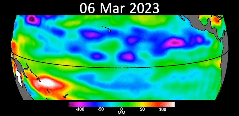
This animation shows a series of waves, called Kelvin waves, moving warm water across the equatorial Pacific Ocean from west to east during March and April.
The signals can be an early sign of a developing El Niño, and were detected by the Sentinel-6 Michael Freilich sea level satellite.
Credit: NASA/JPL-Caltech
From ScitechDaily by Jet Populsion Lab
Kelvin waves, a potential precursor of El Niño conditions in the ocean, are rolling across the equatorial Pacific toward the coast of South America.
Sentinel-6 Michael Freilich satellite data indicates early signs of a potential El Niño, a climate phenomenon known to disrupt global weather patterns.
The data shows Kelvin waves carrying warmer water and higher sea levels across the Pacific, with potential global weather impacts anticipated.
The most recent sea level data from the U.S.-European satellite Sentinel-6 Michael Freilich indicates early signs of a developing El Niño across the equatorial Pacific Ocean.
The data shows Kelvin waves – which are roughly 2 to 4 inches (5 to 10 centimeters) high at the ocean surface and hundreds of miles wide – moving from west to east along the equator toward the west coast of South America.
When they form at the equator, Kelvin waves bring warm water, which is associated with higher sea levels, from the western Pacific to the eastern Pacific.
A series of Kelvin waves starting in spring is a well-known precursor to an El Niño, a periodic climate phenomenon that can affect weather patterns around the world.
It is characterized by higher sea levels and warmer-than-average ocean temperatures along the western coasts of the Americas.
Water expands as it warms, so sea levels tend to be higher in places with warmer water.
El Niño is also associated with a weakening of the trade winds.
The condition can bring cooler, wetter conditions to the U.S.
Southwest and drought to countries in the western Pacific, such as Indonesia and Australia.
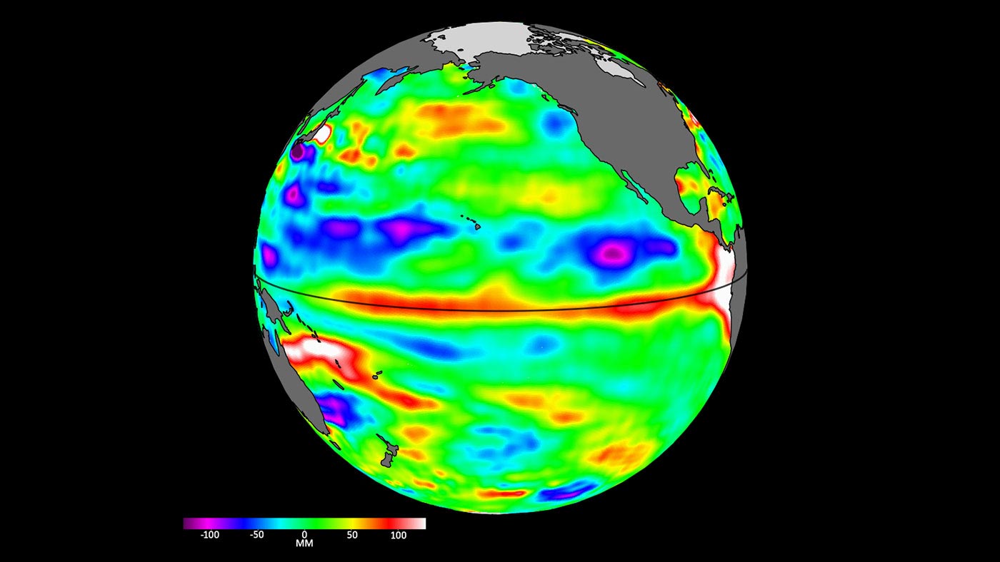
Sea level data from the Sentinel-6 Michael Freilich satellite on April 24 shows relatively higher (shown in red and white) and warmer ocean water at the equator and the west coast of South America.
Water expands as it warms, so sea levels tend to be higher in places with warmer water.
Credit: NASA/JPL-Caltech
Water expands as it warms, so sea levels tend to be higher in places with warmer water.
Credit: NASA/JPL-Caltech
The Sentinel-6 Michael Freilich satellite data shown here covers the period between the beginning of March and the end of April 2023.
By April 24, Kelvin waves had piled up warmer water and higher sea levels (shown in red and white) off the coasts of Peru, Ecuador, and Colombia.
Satellites like Sentinel-6 Michael Freilich can detect Kelvin waves with a radar altimeter, which uses microwave signals to measure the height of the ocean’s surface.
When an altimeter passes over areas that are warmer than others, the data will show higher sea levels.
“We’ll be watching this El Niño like a hawk,” said Josh Willis, Sentinel-6 Michael Freilich project scientist at NASA’s Jet Propulsion Laboratory in Southern California.
“If it’s a big one, the globe will see record warming, but here in the Southwest U.S.
we could be looking at another wet winter, right on the heels of the soaking we got last winter.”
Both the U.S. National Oceanic and Atmospheric Administration (NOAA) and the World Meteorological Organization have recently reported increased chances that El Niño will develop by the end of the summer.
Continued monitoring of ocean conditions in the Pacific by instruments and satellites such as Sentinel-6 Michael Freilich should help to clarify in the coming months how strong it could become.
“When we measure sea level from space using satellite altimeters, we know not only the shape and height of water, but also its movement, like Kelvin and other waves,” said Nadya Vinogradova Shiffer, NASA program scientist and manager for Sentinel-6 Michael Freilich in Washington.
“Ocean waves slosh heat around the planet, bringing heat and moisture to our coasts and changing our weather.”
More About the Mission
Sentinel-6 Michael Freilich, named after former NASA Earth Science Division Director Michael Freilich, is one of two satellites that compose the Copernicus Sentinel-6/Jason-CS (Continuity of Service) mission.
Sentinel-6/Jason-CS was jointly developed by ESA (European Space Agency), the European Organisation for the Exploitation of Meteorological Satellites (EUMETSAT), NASA, and NOAA, with funding support from the European Commission and technical support on performance from the French space agency CNES (Centre National d’Études Spatiales).
Spacecraft monitoring and control, as well as the processing of all the altimeter science data, is carried out by EUMETSAT on behalf of the European Union’s Copernicus program, with the support of all partner agencies.
JPL, a division of Caltech in Pasadena, contributed three science instruments for each Sentinel-6 satellite: the Advanced Microwave Radiometer, the Global Navigation Satellite System – Radio Occultation, and the Laser Retroreflector Array.
NASA also contributed launch services, ground systems supporting operation of the NASA science instruments, the science data processors for two of these instruments, and support for the U.S.
members of the international Ocean Surface Topography Science Team.
Links :
Thursday, May 25, 2023
Lusitania: the maritime disaster that changed World War I
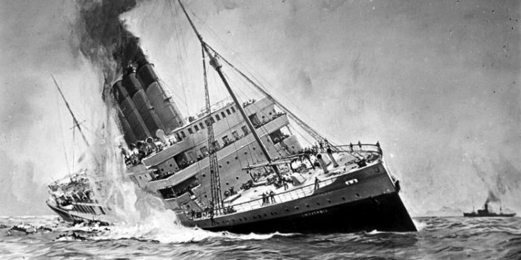
The Lusitania was launched by the Cunard Line in 1906 and was one of the largest ocean liners of its time.
It undertook its first voyage in 1907 and went on to win the Blue Riband, the unofficial award for the fastest transatlantic crossing.
The outbreak of the First World War saw Britain impose a blockade on German ports, which prompted the German Navy to attempt the same on the British Isles.
However, the Royal Navy limited the impact of Germany’s blockade so the Lusitania was able to continue its journeys between Liverpool and New York City.
On 4 February 1915 the commander of the German High Seas Fleet announced that German submarines would begin unrestricted warfare and sink allied ships in the waters around the British Isles. Prior to the Lusitania’s scheduled voyage from the USA on 1 May, the German Embassy in Washington took out newspaper adverts warning that passengers undertook the voyage at their own risk. 1,962 people and around 173 tons of war munitions were on board the Lusitania when it left New York under Captain William Thomas Turner.
Having crossed the Atlantic, the ship was hit on its starboard side at 2.10pm by a torpedo fired by U-20. The Lusitania sank in just 18 minutes and 1,198 people lost their lives.
The German government attempted to justify the sinking, but it was met with outrage in the Allied countries.
Despite the deaths of American civilians, President Wilson chose to remain neutral in the war.
Germany abandoned unrestricted submarine warfare in August, but resumed it in early 1917.
This, and the discovery of the Zimmermann Telegram, led to Wilson’s decision to declare war.
From Safety4Sea
Three years after the Titanic sinking, the maritime route between UK and US was shaken by another major tragedy; the sinking of RMS Lusitania which took lives of almost 1,200 people.
Despite the high death toll, the casualty is less known for the fatalities and mostly known for its contribution to the fueling of the anti-German sentiment that set off a chain of events leading to World War I.
Accident details: At a glance
Type of accident: Sinking
Vessel(s) involved: RMS Lusitania (ocean liner)
Date: 7 May 1915
Place: Atlantic Ocean, off Ireland
Fatalities: 1,198
Pollution: No
Vessel(s) involved: RMS Lusitania (ocean liner)
Date: 7 May 1915
Place: Atlantic Ocean, off Ireland
Fatalities: 1,198
Pollution: No
The incident
On 7 May 1915, the 240-meter-long ocean liner Lusitania was en route from New York, US, to Liverpool, UK, with a total of 1,962 people onboard, including 1,266 passengers and 696 crew members.
The British ship was popular for its speed and luxury and claimed the title of the world’s second-largest ship, surpassed only by its sister ship Mauritania.
While nearing the end of its 202nd journey on the afternoon of 7 May 1915, a torpedo launched by a German U-boat submarine without warning struck and exploded amidships on its starboard side.
Almost immediately, the crew attempted to launch lifeboats, but the ship’s severe list made it impossible.
Only six out of 48 lifeboats were launched successfully.
Shortly after, a heavier explosion occurred, possibly caused by damage to the ship’s steam engines and pipes.
This took the ship down within 20 minutes.
Fatalities
Of the 1,962 passengers and crew aboard Lusitania at the time of the sinking, 1,198 lost their lives.
Shortly following the sinking, several survivors and search and rescue forces from Ireland managed to rescue 764 people, three of whom later died from injuries sustained during the sinking.

Did you know?
The largest death toll ever reported at sea by a torpedo was at the sinking of Wilhelm Gustloff, in January 1945, which killed over 9,000 people.
This also claims the title of the largest ever death toll by a sinking ship.
Probable causes
In contrast to safety mishaps that are to blame in most maritime tragedies, this incident is purely attributed to diplomatic causes.
In the spring of 1915, Germany had declared the seas around the United Kingdom a war zone, in response to the UK declaring the North Sea a war zone some months earlier.
This gave Germany the opportunity to stop following the “prize law”, under which a ship should be warned of submarine presence.
After the incident, Germany supported that it had the right to destroy the ship, regardless of any passengers aboard, because the ship was carrying war munitions onboard and it operated under the control of the Admiralty, so it could be converted into an armed auxiliary cruiser to join the war at any time.
This means the Lusitania was a non-neutral vessel in a declared war zone.
On the other hand, the ship was not armed for battle and was carrying hundreds of civilian passengers, which made the ground for the British government to accuse the Germans of breaching the cruiser rules, which indicate that an unarmed vessel should not be attacked without warning.
In addition, when the ship departed New York on 1st May, the German embassy in the United States placed newspaper advertisements warning people of the dangers of sailing on Lusitania.
The cautions were ignored as it was assumed Germany would still allow passengers to get into lifeboats prior to an attack.
After the incident, the British argued that threatening to torpedo all ships indiscriminately was wrong, whether it was announced in advance or not.
According to Britannica, reports of submarine activity off Ireland prompted the British Admiralty to warn the Lusitania to avoid the area and to recommend adopting the evasive tactic of zigzagging, changing course every few minutes at irregular intervals to confuse any attempt by U-boats to plot its course for torpedoing.
However, the ship’s captain ignored these recommendations.
The aftermath
The sinking caused a storm of protest in the United States because 128 American citizens were among the dead.
The Lusitania disaster was not the single reason why the US entered the war, but it certainly solidified the public perception of the US against Germany, so it is considered one of the factors in the declaration of war nearly two years later.
The fact that Germany took a stance on the attack after the tragedy, arguing that it was fair, boosted the anti-German sentiment also in London, where riots broke out.
The tip of the iceberg was the disclosure of the Zimmerman telegram, under which a potential alliance between Germany and Mexico was discussed in case the US entered the war.
Overall, the sinking of Lusitania negatively affected the image of Germany, signaling to the US that neutrality was not an option.
Links :
Wednesday, May 24, 2023
Why it’s time we changed our view of the world (again)
This blog was originally written as a TEDxBoston talk by Richard Vevers, March 2023.
Is our view of the world fundamentally flawed?
Richard Vevers thinks so. In this fun and insightful talk Vevers reveals how our terrestrial view and beliefs about the world makes us subconsciously ignore the ocean and its importance.
He explains how this is undermining our ability to understand and solve ocean issues especially the biggest one of them all... climate change.
Climate Change, Education, Environment, Oceans Richard Vevers is an ocean conservationist best know for his leading role in the Netflix Film Chasing Coral and for inventing the camera that took Google Street View underwater.
This talk was given at a TEDx event using the TED conference format but independently organized by a local community.
From The Ocean Agency by Richard Vevers
How our terrestrial perspective undermines our ability to solve global issues like climate change
Our view of our world has changed dramatically through the ages.
We once believed that the world was flat — that we could fall right off the edge.
We once believed our world was at the center of the universe — that everything revolved around us.
Our beliefs about the world have improved over time, but not as much as you might imagine.
We still have a view of our world that is fundamentally flawed: We look at the world from a terrestrial perspective that makes us subconsciously ignore the ocean and its importance.
It’s as if the ocean is not part of our world at all.
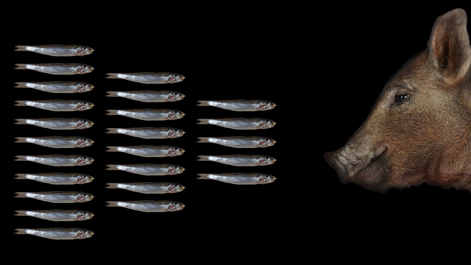
To illustrate our terrestrial perspective, let’s start with a simple question: What’s the most common animal on the planet?
We once believed that the world was flat — that we could fall right off the edge.
We once believed our world was at the center of the universe — that everything revolved around us.
Our beliefs about the world have improved over time, but not as much as you might imagine.
We still have a view of our world that is fundamentally flawed: We look at the world from a terrestrial perspective that makes us subconsciously ignore the ocean and its importance.
It’s as if the ocean is not part of our world at all.
To illustrate our terrestrial perspective, let’s start with a simple question: What’s the most common animal on the planet?
We asked school teachers this question, but less than 5% got the answer right.
So take this Ernst Haeckel illustration as a clue...
So take this Ernst Haeckel illustration as a clue...
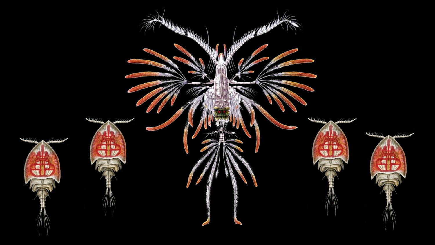
It’s a copepod.
There are a staggering 20 billion copepods in the world for every human.
And most of us haven’t even heard of them.
Here are two more questions: What’s the longest animal? It’s a siphonophore.
These creatures can swarm in the billions, and one was recently discovered that was about four times the length of a blue whale.
Now, what’s the most common form of communication? (Not one of the teachers got this question right…) It’s bioluminescence, which is not that surprising when you consider most animals live in the darkness of the deep ocean.
The reality is that there are so many facts about our world we think we know, but we don’t, because we look at it from a terrestrial perspective and ignore the ocean: the tallest mountain, deepest valley, oldest animal, largest plant… it’s a long list.
Sure, we occasionally think about animals that stick their heads above water or find themselves on our dinner plates.
But pretty much everything else about the ocean we tend to ignore.
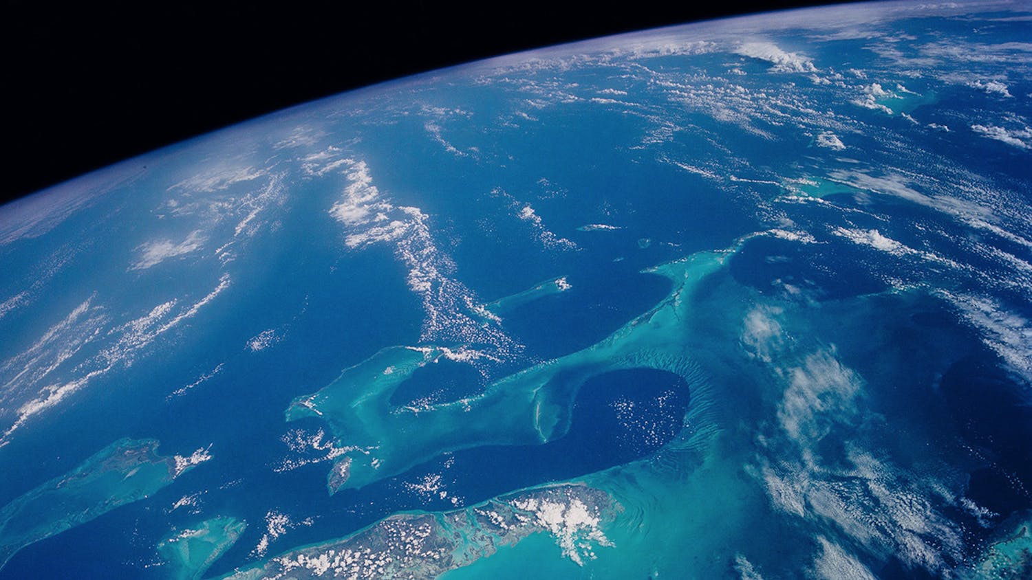
The Bahamas from space, photo NASA
This lack of understanding matters, because the ocean couldn’t be more important.
It’s what makes life on Earth possible.
Its energy, currents and life have been proven to impact every aspect of our lives — from our security to our health and even our wealth.
It’s the driver of catastrophic events like hurricanes, famines, wars and disease outbreaks.
It is also the source of marvels of life that are key to our future.
It couldn’t be more influential in our lives.
But we don’t see any of this from our terrestrial perspective, so we ignore the ocean, not even trying to understand it.
We develop a shallow relationship with it that’s almost entirely based on the enjoyment and food we can get from it.
We don’t even see the point in educating our kids about the ocean.
Over 95% of countries don’t have ocean education in their curricula.
One billion kids are currently growing up without an ocean education, just like their parents and grandparents.
Think about how bizarre that is for a moment.
We don’t teach our kids about the one thing that’s essential to life on Earth.
By not teaching about the ocean, we reinforce the idea that the ocean isn’t important, and the belief becomes self-perpetuating.
It also helps instill a widespread fear of the ocean; a fear of the unknown.
By not teaching about the ocean, we reinforce the idea that the ocean isn’t important.
Now, I’m no different from everyone else.
I grew up loving the ocean — but without an ocean education — and I rarely thought about its importance.
It’s only recently that I’ve learned to look at our world from a different perspective and try to understand it better.
I’m fascinated by communication about the ocean but the one thing that always surprised me is just how difficult it is to engage people, even those who claim to love the ocean.
You have to go to extreme lengths to get public interest.
For the longest time, I really struggled to understand why ocean communication was so hard.
Then I had an experience that completely changed my view.
I went for a snorkel in the open ocean.
It was in a location way beyond sight of land, in water that was crystal-clear and a couple of miles deep, making it an incredible dark blue color.
When I jumped in, what I saw took my breath away.
It wasn’t a whale or shark — there wasn’t even a fish in sight.
It was something completely different.
It was the energy.
The magical rays of light were spotlighting microscopic life before disappearing into the darkness; the swell was interacting with the waves.
Everything was moving.
Absolutely nothing was still.
Having everything move and nothing be still is something we almost never experience in life.
The whole scene seemed full of energy.
It felt like I was seeing the ocean for the first time – I could sense its power, and I certainly felt my own vulnerability.
The experience reminded me a lot of something astronauts talk about: the Overview Effect.
It’s the profound experience you get when seeing the Earth from a new perspective.
So, I started calling my experience the Oceanview Effectand began trying to find other people who’ve had the same experience.
I found two groups: ocean scientists and offshore sailors.
Both head out into the open ocean and occasionally jump in.
Scientists and sailors alike lit up when asked about the Oceanview Effect and talked vividly about it.
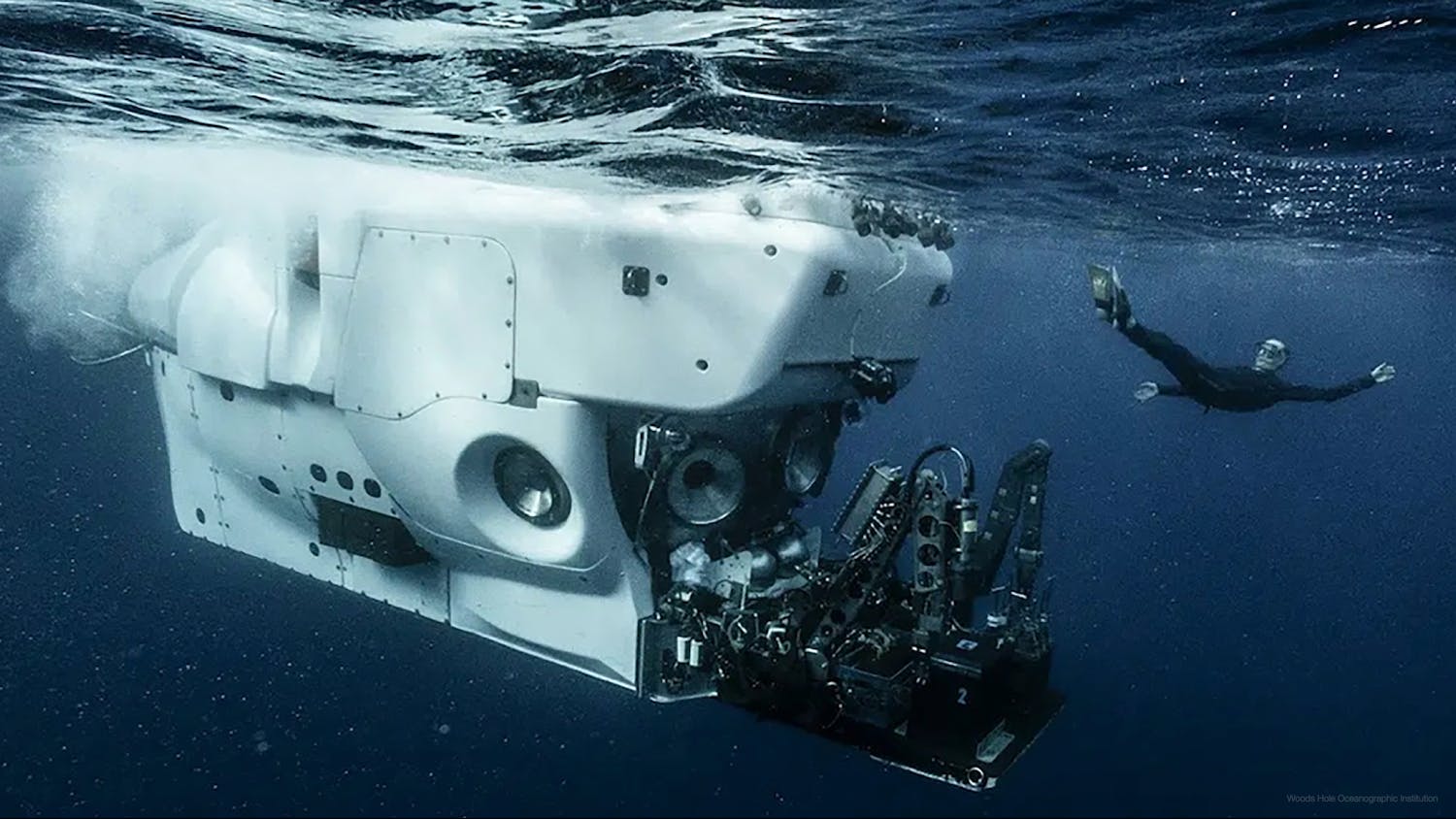
Photo Woods Hole Oceanographic Institution
It was these conversations that inspired me to investigate the phenomenon more deeply.
I read a book called Sea People that was about Ancient Polynesian voyagers who described their view of the ocean.
Polynesians didn’t refer to the ocean as a body of water like we do.
Instead, they referred to it as energy.
They saw it as the energy of life, with the power to create and destroy.
They even described the ocean as an actual relative, which makes sense when you consider the water in our bodies was once in the ocean.
In fact, we’re about 60% ocean.
What I found most insightful, though, was that Polynesians described the ocean that was visible from shore very differently than the ocean beyond the horizon.
They called the ocean close to shore “dead” and the ocean beyond the reef and horizon “alive.” They weren’t referring to the lack of marine life in coastal waters — life was abundant there.
They were simply referring to the nature and energy of the ocean.
We tend to look at the ocean from the shore, and we almost never see its true nature.
So, what would happen if we accepted that we have a false perspective of our world and made a conscious effort to think about it from an ocean perspective, prioritize our understanding of the ocean, even — dare I say it — teach ocean education in schools?
For starters, we’d understand the issue of climate change far better.
There’s currently little awareness about even the basic concepts governing the ocean’s fundamental role in the issue.
The deep blue color of the ocean helps it absorb over 90% of the extra heat energy.
And it’s this energy that’s powering climate change impacts on land.
The ocean creates a delaying effect so we don’t experience the full impacts on land for about two decades.
This means the issue is about 20 years more advanced than most people realize.
We should all have this kind of basic understanding, and it should be driving our response.
Ocean awareness wouldn’t just help us understand the climate issue.
It would help us solve it.
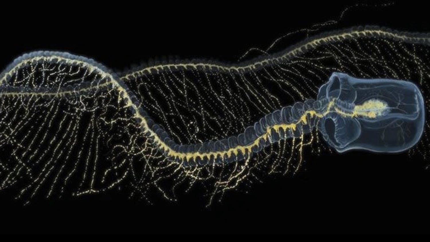
Photo Woods Hole Oceanographic Institution
This is where it gets exciting.
Most people aren’t aware of simple, yet amazing concepts.
For example, carbon travels down in the ocean, not up.
Those copepods we mentioned earlier? They’re little carbon-capturing devices that eat carbon and excrete it to the ocean floor.
And there are 20 billion of them for every one of us.
We focus on building carbon-capturing machines on land, but we rarely think about the potential of protecting and nurturing our countless billions of copepods.
Siphonphones and their relatives, salps, are even better carbon-capturing devices.
They’re voracious predators that can clone themselves.
Some can double in size every 10 hours.
That’s right —nature has already invented cloning carbon-capturing devices! And they’re already removing about the same amount of carbon as the civil aviation industry emits.
Imagine if we understood how to safely leverage that process.
If we better supported ocean science, we could get these answers.
Ocean awareness would also make us notice just how bizarre some of our actions seem to be: We catch fish to feed to livestock.
Tens of millions of tons of fish.
We transform a fabulous climate solution into a climate problem – even subsiding the process.
We trawl the seafloor, where carbon is safely being stored, in search of seafood.
Again transforming a fabulous climate solution into a climate problem.
To put it bluntly, we’re making elementary mistakes because we didn’t get taught about the ocean in elementary school.
Fortunately, our view of the ocean, and our understanding of it, is going to change.
I think this is inevitable.
Our need to solve climate change is forcing us to finally consider the ocean’s role and its importance.
The only question is how quickly this will happen — whether we learn fast enough to help solve climate change.
And that’s where you come in.
You can act on this idea and be one of the first to change your perspective of our world and learn about the ocean.
It’s not difficult.
You can even help others do the same by spreading the idea.
If you do, I bet you’ll see that there is a lot more we can be doing to solve climate change, and it will make you feel a lot more optimistic about the future.
Links :
Tuesday, May 23, 2023
Their boat hit a whale and sank. The Internet saved their lives.

The Raindancer’s hull was reinforced to withstand an impact, its owner said, but the whale’s impact caused cracks that sent water into the sailboat in a matter of seconds.
Credit... Tommy Joyce
After the collision in the Pacific Ocean this month, Rick Rodriguez and three other sailors were rescued by a fellow boater, with an assist from a satellite internet signal.
When Rick Rodriguez’s sailboat collided with a whale in the middle of the Pacific Ocean earlier this month, it sank within about 15 minutes.
But not before he and his three fellow mariners had escaped with essential supplies and cutting-edge communications gear.
One was a pocket-size satellite device that allowed Mr. Rodriguez to call his brother, who was thousands of miles away on land, from a life raft.
That call would set in motion a successful rescue effort by other sailors in the area who had satellite internet access on their boats.
“Technology saved our lives,” Mr. Rodriguez later wrote in an account that he typed on his iPhone from the sailboat that had rescued him and his crew.
People involved in the roughly nine-hour rescue say it illustrates how newer satellite technologies, especially Starlink internet systems, operated by the rocket company SpaceX since 2019, have dramatically improved emergency communication options for sailors stranded at sea — and the people trying to find them.
“All sailors want to help out,” said Tommy Joyce, a friend of Mr Rodriguez who helped organize the rescue effort from his own sailboat.
“But this just makes it so much easier to coordinate and help boaters in distress.”
Starlink’s service gives vessels access to satellite signals that reach oceans and seas around the globe, according to the company.
The fee-based connection allows sailors to reach other vessels on their own, instead of relying solely on sending distress signals to government-rescue agencies that use older, satellite-based communication technologies.
But the rapid rescue would not have been possible without the battery-powered satellite device that Mr.
Rodriguez used to call his brother.
Such devices have only been used by recreational sailors for about a decade, according to the United States Coast Guard.
This one’s manufacturer, Iridium, said in a statement that the device is “incredibly popular with the sailing community.”

A SpaceX rocket carrying a batch of Starlink satellites lifting off this month from Cape Canaveral, Fla.Credit...Craig Bailey/Florida Today, via Associated Press
“The recent adoption of more capable satellite systems now means sailors can broadcast distress to a closed or public chat group, sometimes online, and get an instant response,” said Paul Tetlow, the managing director of the World Cruising Club, a sailing organization whose members participated in the rescue.
A sinking feeling
Whales don’t normally hit boats.
In a famous exception, one rammed the whaling vessel Essex as it crisscrossed the Pacific Ocean in 1820, an accident that was among the inspirations for Herman Melville’s 1851 novel “Moby Dick.”
In Mr. Rodriguez’s case, a whale interrupted a three-week voyage by his 44-foot sailboat, Raindancer, from the Galápagos Islands in Ecuador to French Polynesia.
At the time of the impact on March 13, the boat was cruising at about seven miles per hour and its crew was busy eating homemade pizza.
Mr. Rodriguez would later write that making contact with the whale — just as he dipped a slice into ranch dressing — felt like hitting a concrete wall.
Even as the boat sank, “I felt like it was just a scene out of a movie," Alana Litz, a friend of Mr. Rodriguez and one of the sailors on Raindancer, told NBC’s “Today” program last week.
The story of the rescue had been reported earlier by The Washington Post.

Whales surfacing in the waters off the Galápagos Islands in the Pacific Ocean in 2016.
They don’t normally hit boats, but one is believed to be the culprit behind the sinking of Raindancer off the coast of Peru.Credit...Reinhard Dirscherl\Ullstein Bild, via Getty Images
They don’t normally hit boats, but one is believed to be the culprit behind the sinking of Raindancer off the coast of Peru.Credit...Reinhard Dirscherl\Ullstein Bild, via Getty Images
Raindancer’s hull was reinforced to withstand an impact with something as large and heavy as a cargo container.
But the collision created multiple cracks near the stern, Mr. Rodriguez later wrote, and water rose to the floorboards within about 30 seconds.
Minutes later, he and his friends had all escaped from the boat with food, water and other essential supplies.
When he looked back, he saw the last 10 feet of the mast sinking quickly.
As a line that had been tying the raft to the boat started to come under tension, he cut it with a knife.
That left the Raindancer crew floating in the open ocean, about 2,400 miles west of Lima, Peru, and 1,800 miles southeast of Tahiti.
“The sun began to set and soon it was pitch dark,” Mr. Rodriguez, who was not available for an interview, wrote in an account of the journey that he shared with other sailors.
“And we were floating right smack in the middle of the Pacific Ocean with a dinghy and a life raft.
Hopeful that we would be rescued soon.”
‘Not a drill’
Before Raindancer sank, Mr. Rodriguez activated a satellite radio beacon that instantly sent a distress alert to coast guard authorities in Peru, the country with search and rescue authority over that part of the Pacific, and the United States, where his boat was registered.
In 2009, a U.S Coast Guard helicopter rescued a sailboat crewwhose vessel had collided with a whale and sank about 70 miles off the coast of Mexico.
But Raindancer’s remote location made a rescue like that one impossible.
So in the hour after it sank, U.S. Coast Guard officials used decades-old satellite communications technology to contact commercial vessels near the site of the accident.
One vessel responded to say that it was about 10 hours away and willing to divert.
But, in the end, that was not necessary because Mr. Rodriguez’s satellite phone call to his brother Roger had already set a separate, successful rescue effort in motion.
Mr. Rodriguez’s brother contacted Mr. Joyce, whose own boat, Southern Cross, had left the Galápagos around the same time and was about 200 miles behind Raindancer when it sank.
Because Southern Cross had a Starlink internet connection, it became a hub for a rescue effort that Mr. Joyce, 40, coordinated with other boats using WhatsApp, Facebook and several smartphone apps that track wind speed, tides and boat positions.
“Not a drill,” Mr. Joyce, who works in the biotech industry, often from his boat, wrote on WhatsApp to other sailors who were in the area.
“We are in the Pacific headed that direction but there are closer vessels.”
After a flurry of communication, several boats began sailing as quickly as possible toward Raindancer’s last known coordinates.

Tommy Joyce, communicating from the cabin of the Southern Cross.
He organized the rescue effort from his sailboat after the Raindancer sank earlier this month.Credit...Tommy Joyce
He organized the rescue effort from his sailboat after the Raindancer sank earlier this month.Credit...Tommy Joyce
SpaceX did not respond to an inquiry about the system’s coverage in the Pacific.
But Douglas Samp, who oversees the Coast Guard’s search and rescue operations in the Pacific, said in a phone interview that vessels only began using Starlink internet service in the open ocean this year.
Mr. Joyce said that satellite internet had been key to finding boats that were close to the stranded crew.
“They were all using Starlink,” he said, speaking in a video interview from his boat as it sailed to Tahiti.
“Can you imagine if we didn’t have access?”
Of course, there was one sailboat captain without a Starlink signal during the rescue: Mr. Rodriguez.
After night fell over the Pacific, he and his fellow sailors resorted to the ancient method of sitting in a life raft and hoping for the best.
In the darkness, the wind picked up and flying fish jumped into their dinghy, according to Mr. Rodriguez’s account.
Every hour or so, they placed a mayday call on a hand-held radio, hoping that a ship might happen to pass within its range.
None did.
But after a few more hours of anxious waiting, they saw the lights of a catamaran and heard the voice of its American captain crackling over their radio.
That is when they screamed in relief.
Links :
Monday, May 22, 2023
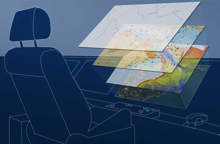
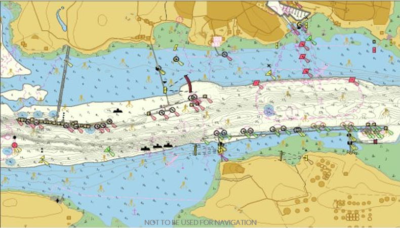
Rescheming and improving GB Electronic Navigational Chart data
While this data will still be presented seamlessly to users when displayed in ECDIS, it will result in improved consistency of both the scale of data and features within the ENCs.
From Admiralty
In
readiness for the next generation of navigational solutions, the UK
Hydrographic Office (UKHO) has embarked on a project to enhance the
content of its GB Electronic Navigational Charts (ENCs) and other
ADMIRALTY products.
This data improvement will enhance consistency, safety and the overall user experience for mariners. 
Preparing for a digital future
The UKHO is continuing to build the foundations to develop new ADMIRALTY digital solutions underpinned by the International Hydrographic Organization’s new data standard: S-100.
The UKHO is continuing to build the foundations to develop new ADMIRALTY digital solutions underpinned by the International Hydrographic Organization’s new data standard: S-100.
The standard will enable interoperable layers of data to seamlessly bring together a wide range of information, including next-generation ENCs (S-101), bathymetric surface data (S-102), water levels (S-104) and surface currents data (S-111).
Powered by satellite connectivity, this data will be delivered more dynamically and in near real-time to provide an even more accurate picture of the marine environment.
Undoubtably, this will bring significant safety and efficiency benefits including voyage optimisation for many users.
What is scheming?
In this case, a scheming refers to the scale of the data and position of the limits between individual products, such as paper charts or ENCs.
Existing GB ENCs (using the S-57 standard) currently use a scheme that has been derived from their paper chart origins.
What is scheming?
In this case, a scheming refers to the scale of the data and position of the limits between individual products, such as paper charts or ENCs.
Existing GB ENCs (using the S-57 standard) currently use a scheme that has been derived from their paper chart origins.
However, the new technical generation of ENCs (using the S-101 standard) will be compiled using a new, standardised gridded scheme to ensure seamless interoperability with other S-100 data sets.
Why rescheme existing ENC limits?
With S-101 ENCs becoming carriage compliant by 2026, the UKHO is now working to rescheme its S-57 GB ENCs into a gridded format in readiness for the transition.
Why rescheme existing ENC limits?
With S-101 ENCs becoming carriage compliant by 2026, the UKHO is now working to rescheme its S-57 GB ENCs into a gridded format in readiness for the transition.
By supplying data in a regular and consistent shape, this will enable additional information (using the S-100 data standard) to be overlaid in an interoperable ‘data stack’ in the future.
Rescheming will not only help prepare for future data products, but it will also result in a more consistent scheming and improved content for existing S-57 ENCs.
Rescheming will not only help prepare for future data products, but it will also result in a more consistent scheming and improved content for existing S-57 ENCs.
While data in current S-57 ENCs appears seamless when viewed by the mariner in ECDIS, its paper chart origins have resulted in some variation in scale and content when viewed across data limits, which we are aware has been noticed by the user community.
Current variations across data limits do not present any danger to today’s mariners.
Current variations across data limits do not present any danger to today’s mariners.
However, user feedback has shown that inconsistences can undermine confidence in the eyes of the navigator.
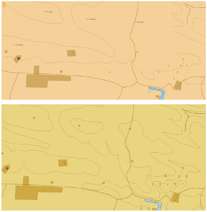
An example of this is variations in contour intervals.
For instance, one chart may display contour intervals of 2m, 5m, 10m, 15m and 20m, while an adjacent chart may only show intervals of 2m, 5m, 10m and 20m.
For instance, one chart may display contour intervals of 2m, 5m, 10m, 15m and 20m, while an adjacent chart may only show intervals of 2m, 5m, 10m and 20m.
While this does not present a danger, it can result in confusion when making navigational decisions; this is something the project seeks to address.
Our approach
Due to the paper chart origins of the current data limits, the data coverage does not match the limits of the grid when the new scheme is applied.
To put the mariners’ needs at the forefront of all decisions made, we are taking a flexible approach to this task.
With each instance of inconsistency, we have been asking: can the data be adjoined to the adjacent ENC?
With each instance of inconsistency, we have been asking: can the data be adjoined to the adjacent ENC?
Does it offer any useful information, or can it be deleted?
Or can any additional information be captured to complete a new ‘square’ of the grid?
By considering the unique requirements for each ENC cell, we have been able to make more flexible, user-oriented decisions to result in more harmonised, consistent coverage.
By considering the unique requirements for each ENC cell, we have been able to make more flexible, user-oriented decisions to result in more harmonised, consistent coverage.
At the heart of each decision, we have prioritised mariner safety and overall value.
Safety
To ensure the mariner has the information they need, we have been carefully assessing instances that may result in important features being divided across two separate ENCs. Similarly, we have considered where strategic decisions have been made in the original scheming to include certain navigational features, scales and sizes. Crucially, prior to any reschemed ENC being published, our teams have been conducting considerable testing to ensure they are fit for purpose.
We have been collaborating closely with stakeholders, such as local port authorities, to ensure they meet the needs of users. We are also engaging closely with other national hydrographic offices who use a gridded scheme and have found that regardless of the chosen scheming (i.e. paper chart scheme or gridded scheme) data will still be presented seamlessly to users when displayed in ECDIS.
As the UKHO is responsible for providing coverage for UK waters and more than 63 nations worldwide, we recognise it is essential for this scheme to work successfully on a global scale and will be working with other national hydrographic offices across the globe to ensure alignment.
Value
As the rescheme is seeking to improve consistency and create more regular data limits, this will inevitably create more GB ENCs as a result.
However, we have chosen to take a flexible approach as outlined above to ensure these rescheme ENCs will meet the informational needs of the mariner.
As part of our thorough testing process, we have conducted trials to ensure the size of each ENC best represents the navigational features and source data contained within it.
Improving GB ENC data
As part of this rescheming, the project has also presented opportunities to improve the data shown on the ENC in response to customer feedback:
Consistency - By identifying areas in which adjacent ENCs have different scale source data (and potentially different contour intervals or chart content), we are seeking to improve overall consistency of both the scale of data and the features within the ENCs.
High density contours - We are also providing additional ‘high density’ ENCs for key areas (where supported by suitable data). These HD ENCs are contoured at 1m or 0.5m intervals, enabling the mariner to choose the most appropriate safety contour for the draught of their vessel and more clearly visualise navigable water – particularly in confined or shallow waterways.
Enriched topography - User feedback has indicated that mariners would prefer more topographic detail as a visual reference (enabling them to match the information on their ECDIS and RADAR with the view out their window). Therefore, we have been able to enrich the interval frequency of topographic contours and update urban areas, as shown.
What progress has been made so far?
We have already published the first reschemed ENCs, containing improved coverage of Milford Haven in Wales – a large port frequented by oil, chemical and LNG tankers, as well as pleasure and sailing vessels.
Here, we worked closely with pilots at the Port of Milford Haven to consider their local knowledge when focusing on the area.
This data improvement resulted in the publication of new HD ENC coverage, which was developed and tested with the Port Authority.
These new ENCs will enable ships to navigate with enhanced precision and greater confidence of their under-keel clearance.
Representatives from the Port of Milford Haven commented:
“The HD ENCs have been absolutely fantastic. Choke point areas in the past have now gone as a result of the user having more water space; the pilots are now using parts of the channel that they wouldn’t have used in the past.”
What's next?
Representatives from the Port of Milford Haven commented:
“The HD ENCs have been absolutely fantastic. Choke point areas in the past have now gone as a result of the user having more water space; the pilots are now using parts of the channel that they wouldn’t have used in the past.”
What's next?
Addressing inconsistences and variations in data is a necessary step in the transition towards S-101 ENCs.
Once the coverage has been successfully reschemed, the UKHO will be in a position to begin converting S-57 data into S-101 in readiness for future ECDIS carriage compliance regulations in 2026, in line with its ambitions to be at the forefront of the development of next-generation data solutions.
Links :
- GeoGarage blog : Rescheming NOAA ENCs is underway. What does that mean?
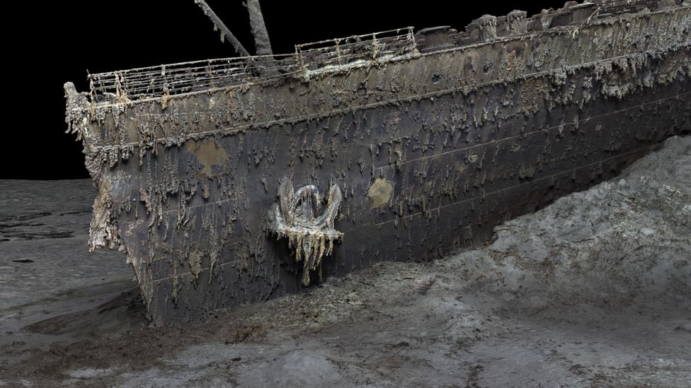
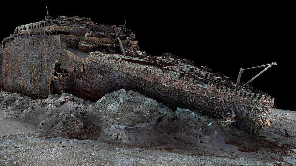
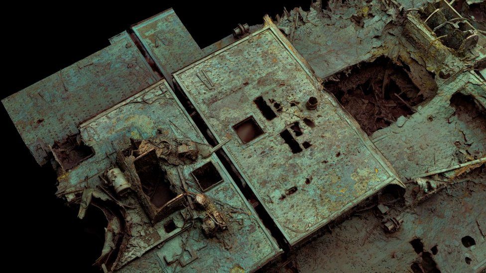
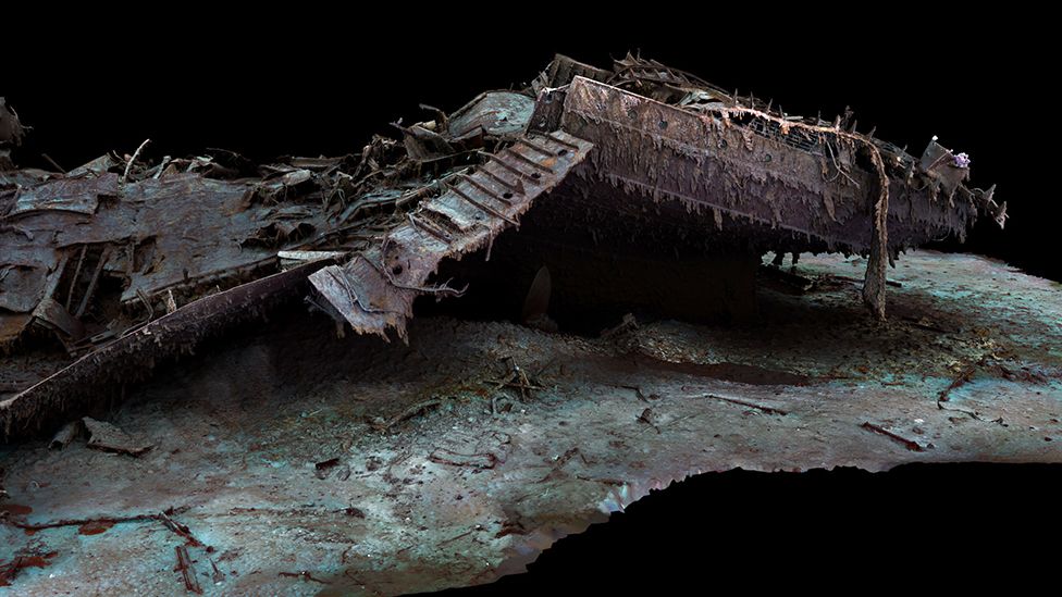
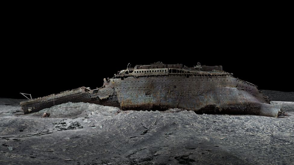
Titanic: First ever full-sized scans reveal wreck as never seen before
3D scanning technology will allow us to study the Titanic from the comfort of dry land.
Magellan, a deep sea mapping company, has completed a full scan of the vessel as it lies on the ocean floor.
From BBC by Rebecca Morelle & Alison Francis
The world's most famous shipwreck has been revealed as never seen before.
The first full-sized digital scan of the Titanic, which lies 3,800m (12,500ft) down in the Atlantic, has been created using deep-sea mapping.
It provides a unique 3D view of the entire ship, enabling it to be seen as if the water has been drained away.
The hope is that this will shed new light on exactly what happened to the liner, which sank in 1912.
More than 1,500 people died when the ship struck an iceberg on its maiden voyage from Southampton to New York.
"There are still questions, basic questions, that need to be answered about the ship," Parks Stephenson, a Titanic analyst, told BBC News.
He said the model was "one of the first major steps to driving the Titanic story towards evidence-based research - and not speculation."
 Atlantic Productions/Magellan
The bow of the Titanic is still instantly recognisable even after so long underwater
The Titanic has been extensively explored since the wreck was discovered in 1985.
But it's so huge that in the gloom of the deep, cameras can only ever show us tantalizing snapshots of the decaying ship - never the whole thing.
The new scan captures the wreck in its entirety, revealing a complete view of the Titanic.
The new scan captures the wreck in its entirety, revealing a complete view of the Titanic.
It lies in two parts, with the bow and the stern separated by about 800m (2,600ft).
A huge debris field surrounds the broken vessel.
The scan was carried out in summer 2022 by Magellan Ltd, a deep-sea mapping company, and Atlantic Productions, who are making a documentary about the project.
Submersibles, remotely controlled by a team on board a specialist ship, spent more than 200 hours surveying the length and breadth of the wreck.
They took more than 700,000 images from every angle, creating an exact 3D reconstruction.
 Atlantic Productions/Magellan
The scan is made up from 700,000 images captured by submersibles
 Atlantic Productions/Magellan
The large hole to the right of the boat deck opens over where the grand staircase once stood
Magellan's Gerhard Seiffert, who led the planning for the expedition, said it was the largest underwater scanning project he'd ever undertaken.
"The depth of it, almost 4,000m, represents a challenge, and you have currents at the site, too - and we're not allowed to touch anything so as not to damage the wreck," he explained.
"And the other challenge is that you have to map every square centimetre - even uninteresting parts, like on the debris field you have to map mud, but you need this to fill in between all these interesting objects."
The scan shows both the scale of the ship, as well as some minute details, such as the serial number on one of the propellers.
 Atlantic Productions/Magellan
The stern, which has separated from the bow, is a chaotic tangle of steel
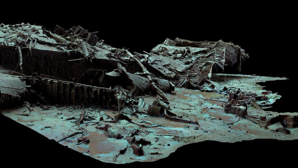 Atlantic Productions/Magellan
The stern corkscrewed into the seabed as it plunged into the depths
The bow, now covered in stalactites of rust, is still instantly recognisable even 100 years after the ship was lost.
Sitting on top is the boat deck, where a gaping hole provides a glimpse into a void where the grand staircase once stood.
The stern though, is a chaotic mess of metal.
The stern though, is a chaotic mess of metal.
This part of the ship collapsed as it corkscrewed into the sea floor.
In the surrounding debris field, items are scattered, including ornate metalwork from the ship, statues and unopened champagne bottles.
In the surrounding debris field, items are scattered, including ornate metalwork from the ship, statues and unopened champagne bottles.
There are also personal possessions, including dozens of shoes resting on the sediment.
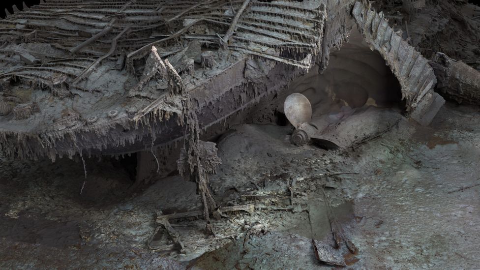 Atlantic Productions/Magellan
Extraordinary detail can be seen of the ship
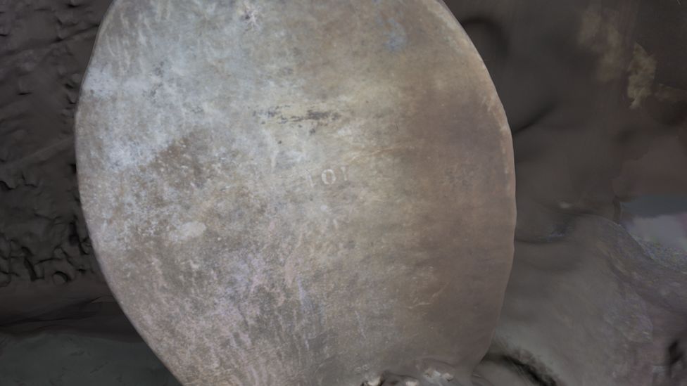 Atlantic Productions/Magellan
The serial number on a propeller can be made out
Parks Stephenson, who has studied the Titanic for many years, said he was "blown away" when he first saw the scans.
"It allows you to see the wreck as you can never see it from a submersible, and you can see the wreck in its entirety, you can see it in context and perspective. And what it's showing you now is the true state of the wreck."
He said that studying the scans could offer new insight into what happened to the Titanic on that fateful night of 1912.
"We really don't understand the character of the collision with the iceberg. We don't even know if she hit it along the starboard side, as is shown in all the movies - she might have grounded on the iceberg," he explained.
Studying the stern, he added, could reveal the mechanics of how the ship struck the sea floor.
 Atlantic Productions/Magellan
The hope is that the scan could reveal more about what happened on the night the Titanic was lost
The sea is taking its toll on the wreck, microbes are eating away at it and parts are disintegrating. Historians are well aware that time is running out to fully understand the maritime disaster.
But the scan now freezes the wreck in time, and will allow experts to pore over every tiny detail.
The hope is the Titanic may yet give up its secrets.
Links :
- BBC : 'Haunting' new footage of Titanic shipwreck / The book that records all disasters at sea
- ExplorersWeb : New Photos of the Titanic as You’ve Never Seen It
- NYTimes : ‘Digital Twin’ of the Titanic Shows the Shipwreck in Stunning Detail
- DailyMail : What happened to the missing passengers of the Titanic? As eerie new photos show shoes left in the wreckage, experts reveal to MailOnline where the 1,160 are likely to be / Treasures of the Titanic: From the violin played by musician Wallace Hartley as the ship sank to the watch frozen in time, how surviving items have resurfaced in auctions
- GeoGarage blog : Maritime infographic: The fall of the mighty ... / Explorers can take Titanic's Marconi ... / Titanic sinks in real time / Challenge to Titanic sinking theory / New images of Titanic wreck revealed / Titanic items to be sold 100 years after sinking / New expedition to Titanic site will create 3D ... / The Titanic disaster and its aftermath / A 26-year-old Titanic mystery solved. The discovery leads to new ... / How to escape a sinking ship (like, say, the Titanic) / Titanic sank due to enormous uncontrollable fire, not iceberg ... / First map of entire Titanic wreck site sheds new light on ... / Vow to “virtually raise the Titanic”: new 3-D images taken of ... / Challenge to Titanic sinking theory / Her tale will go on: Titanic survivor's story sold at auction / Titanic threat: why do ships still hit icebergs?
Sunday, May 21, 2023
Tiger shark attacks kayak fisherman off Oahu
Noon on May 12, 2023.
Windward side of Oahu. 55ft deep, less than 2 miles from shore.
Heard a "whooshing" sound, looked up and saw a wide brown thing on the side of the kayak.
Thought it was a turtle at first.
Happened so fast.
Didn't realize I took my left foot out of the water to brace myself from impact and actually pushed the shark's head off with it.
If you asked me to do that again, even without the shark, I don't think I'd have that flexiblity.
I actually only thought the shark rammed the kayak until I saw the video at home.
From CBS news by Alex Sundby
A shark attacked a man fishing from his kayak off the coast of Hawaii in a harrowing encounter that he caught on video.
The man wasn't hurt in the brief attack.
Scott Haraguchi was fishing less than 2 miles off the island of Oahu around midday Friday.
After he caught a fish, he told a local TV station he left his GoPro camera running.
"It was incredibly bad luck but incredibly good luck to capture it," Haraguchi told KITV.
In the video, which Haraguchi posted to YouTube, the shark is seen coming straight at the kayak and opening its large mouth right before ramming the small watercraft.
Haraguchi screams as the shark's head slides along the side of the kayak and closer to him during the collision.
Haraguchi manages to kick the shark with his left foot, and it goes back into the water.
Haraguchi manages to kick the shark with his left foot, and it goes back into the water.
He said later he initially thought the animal was a turtle before he realized he just had a close encounter with a shark.
"Tiger shark!" Haraguchi yells out in the video after the attack.
"Tiger shark!" Haraguchi yells out in the video after the attack.
"Tiger shark rammed me. Holy f-."
He wrote on YouTube that it all happened so fast he didn't realize exactly what happened until he checked out the GoPro footage at home.
"If you asked me to do that again, even without the shark, I don't think I'd have that flexibility," Haraguchi wrote on YouTube.
He told KITV he assumed the shark was looking for a wounded seal he spotted nearby.
"I'm thinking that the shark actually disabled and wounded the seal … was waiting for it to die, came back and thought I was the seal and attacked me instead," he told the station.
Subscribe to:
Posts (Atom)