On the surf spot of Bondi Beach in Sydney
Saturday, July 23, 2016
Friday, July 22, 2016
Super slippery coatings are good for way more than ketchup bottles

courtesy of Getty Images
From Wired by Sarah Zhang
Who among us can deny the satisfying whoosh of ketchup coming clean out of a bottle?
You might remember the ketchup video that lit up the Internet a couple years ago: an anonymous hand tipping a glass bottle of ketchup, which slid out with nary a streak of red. It was magic.
OK, fine.
It was physics.
And the physics of slippery surfaces could be far more revolutionary than a trick for saving a few ounces of condiment.
Sticky stuff sticking to surfaces is a fact of life: Plates and utensils get crusted with food and someone has to wash them each and every time.
But in a world of super slippery coatings, the very concept of “cleaning” goes away.
Startups like SLIPS Technologies and LiquiGlide, the latter of which made the viral ketchup video, are now branching out into the world of industrial applications.
Think ketchup is hard to get out?
Try crude oil.
Or barnacles that attach themselves to a ship like, well, barnacles.
Or bacteria building up a slimy layer in IV lines.
The two companies’ coatings share a basic principle: the liquid-impregnated surface.
As weird as that may sound, it comes out of the idea that to make a surface slippery, you want to make it as smooth as possible.
“The problem is you can’t take a solid surface and make it perfectly smooth on a molecular level,” says Daniel Behr, CEO of SLIPS Technologies.
Instead, these companies coat the jagged surface with a thin layer of liquid, which is smooth.
Both companies are creating a suite of liquid-impregnated surfaces tailored to different applications. The exact formulation of the liquid depends on what you’re trying to keep off the surface—whether ketchup or crude oil or the glue barnacles use to stick to ships.
The key difference is that SLIPS’s uses more liquid over the surface than LiquiGlide’s.
One of SLIPS’s biggest projects right now is combatting the problem of barnacles and mussels—one that actually wastes a huge amount of fuel.
When barnacles and mussels take over a ship’s once-smooth hull, they create drag.
More drag means more fuel to travel the same distance.
The Harvard team that created SLIPS won a $2.7 million Department of Energy grant and is now monitoring square meter patches of its slippery anti-barnacle paint on ships everywhere from New England to the United Kingdom to the Indian Ocean.
Similar coatings could make stents, catheters, and IV lines safer.
Bacteria often grow into a film on these devices, only to make trouble when they infect the body. SLIPS vice president Scott Healy said his company is working with four different medical device companies to test their coatings, though he declined to name them or give specifics.
And last year, just before LiquiGlide made a splash partnering with Elmer’s for glue bottles, it announced with less fanfare that it was getting into the oil and gas industry.
Thick, sticky oil can flow through miles of pipeline before it reaches your house.
The company said it was experimenting with coatings for piles and large, stainless steel tanks.
“We remain excited about [consumer packaged goods] space,” CEO Dave Smith said in an email. “We are also actively exploring applications in other industries.”
Financially, these coatings seem to make sense in places when they would actually save you money, i.e. with an expensive product.
(So not ketchup.)
“It could be very attractive for high end, high sensitivity applications,” says Ali Erdemir, who works on coatings at Argonne National Laboratories.
For example, he speculated, lenses on minimally invasive surgical equipment—or those on surveillance drones and planes flying high in the sky.
The joke goes that if you’re a hammer, everything looks like a nail.
And it you’re super slippery coating, everything looks like a sticky surface to make no-stick.
Bigger than the weather: A corporate cover-up on the high seas

In 2015, 3 South African seamen disappeared in the Southern Ocean.
What happened to them ?
(Bansi cyclone)
From Daily Maverick by Kevin Bloom
In 2015, after three South African seamen went missing somewhere in the vastness of the Southern Ocean, their families tried to trace their final movements.
Uncovering the truth would require going to war with the world’s largest tourism conglomerate, a €20-billion-a-year monolith that had no interest in fielding questions.
Sailing routes and Cyclone Bansi path.
Credit: Andrea Teagle/CARTO
Unscrambled by computers at Nasa’s Earth Observatory, the picture looked like a scene from a sci-fi film.
Perhaps the swirling violet abyss at the photograph’s focal core reminded Nasa’s engineers of the wormhole into which Hollywood astronauts occasionally disappear – and if so, at least for the families of those caught in the vortex, the analogy was apt.
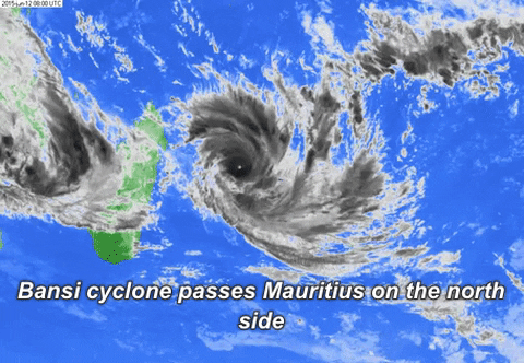
The churning neon thing was the lightning-lit eye of Cyclone Bansi, which had formed the day before and was now gusting at 185km per hour, or 99.89 knots.
It would crest twice over the next few days, into category 4 (113 to 136 knots) and category 5 (137 knots plus), before petering out into a weak extra-tropical system by 19 January.

A view of Cyclone Bansi from the International Space Station.
Credit: NASA
Into this maelstrom sailed a new Leopard 44 catamaran, assembled in Cape Town by boat builders Robertson and Caine.
Under different circumstances, the yacht would have taken the slower and safer route from Cape Town to the Thai island of Phuket, but TUI Marine, the world’s largest yacht charter operator – and the new owner of the Leopard 44 – had a reputation for getting its assets delivered fast.

An image of the upturned hull of what was likely Moorings A5130, Indian Ocean, May 2015; co-ordinates 27-26.4S and 064-30.0E
Saturday, 23rd January. Catamaran hull located adrift at sea:
At 15h30, Saturday, 23rd January, NSRI Agulhas duty crew launched a Sea Rescue craft to attempt to locate a capsized catamaran reportedly sighted approximately 42 nautical miles off-shore of Agulhas. NSRI Hermanus launched a sea rescue craft to stand-by in the area as back-up.
The floating capsized casualty Catamaran has reportedly been sighted on numerous occasions and hopes are that she is the Catamaran Sunsail that has been missing for a year.
On arrival on the scene, following a brief search, the upturned hull of the Catamaran was photographed by NSRI and NSRI rescue swimmers free dived to investigate markings and as much as could be investigated under the hull. NSRI could not positively identify her as Sunsail.
Video by NSRI Agulhas.
For delivery skippers out of South Africa, as for hotel staff, travel agents and cruise ship crews the world over, TUI had become synonymous with employment itself.
If a contractor had issues with a weather forecast – even one as potentially catastrophic as a tropical cyclone – it was odds-on that he’d be replaced.
Read the full Daily Maverick investigation
Wednesday, July 20, 2016
Just where exactly did China get the South China Sea nine-dash line from?
An animated infographic depicting China’s territorial disputes.
Is China trying to expand its territory?
From Time by Hannah Beech
China's territorial claims in the South China Sea are made on the basis of a nine-dash line now ruled spurious by an international court.
But where did the line originate from and why is Beijing so sensitive about it?
A UN-backed tribunal is on Tuesday expected to deliver its verdict on a Philippine challenge over Chinese-occupied territory in the South China Sea.
China claims most of the sea, even waters approaching neighbouring countries, based on a vaguely defined "nine-dash-line" found on a 1940s Chinese map.
The Philippines, and other countries, dispute this claim.
China claims most of the sea, even waters approaching neighbouring countries, based on a vaguely defined "nine-dash-line" found on a 1940s Chinese map.
The Philippines, and other countries, dispute this claim.
Then, on July 12, 2016, an international tribunal ruled that the now nine-dash demarcation could not be used by Beijing to make historic claims to the South China Sea, parts of which are claimed by six governments.
The line, first inscribed on a Chinese map in 1947, had “no legal basis” for maritime claims, deemed the Permanent Court of Arbitration in the Hague.
Beijing reacted with outrage to the judgment, which delegitimized China’s maritime ambitions according to international law.
On July 18, China’s naval chief Wu Shengli told the visiting U.S.
chief of naval operations that Beijing would not halt its controversial campaign to turn the contested South China Sea reefs it controls into artificial islands complete with military-ready airstrips.
China “will never give up halfway” on its island-building efforts, said Wu, according to Chinese state media.
Also on Monday, the Chinese air force announced that it had sent bombers on “normal battle patrols” over Scarborough Shoal, a disputed reef that Beijing effectively seized from Manila in 2012.
Analysts worry that China could next build on Scarborough Shoal, placing a militarized Chinese island off the Philippine coast.
Far from hewing to the international court’s July 12 judgement on the nine-dash line, and contested features within that boundary, Beijing has made clear it considers the award null and void.
Wang Ying, a Chinese marine geographer, also feels aggrieved by the tribunal’s award.
“They didn’t respect history,” she says, of the international court.
“I totally agree with the response of our government.”
The 81-year-old member of the prestigious Chinese Academy of Sciences is the disciple of Yang Huairen, a Chinese geographer who, in 1947, helped etch the U-shaped, 11-dash line on Chinese maps to demarcate roughly 90% of the contested South China Sea for his homeland.
“All the lines have a scientific basis,” says Wang, who still teaches at Nanjing University in eastern China.
“I’m a scientist, not someone in politics.”
Most international law experts believe that China's so-called "indisputable sovereignty" over its maritime claim in the South China Sea has little merit, and is illegal under the United Convention on the Law of the Sea.
The United States said that China's expansive claim increases the risk of confrontation, undermines regional stability, and dims the prospects for diplomacy, and paved the way for "US pivot" to Pacific.
Philippines declares the claim is illegal and violates Philippines' and other nations' sovereign rights under UNCLOS.
The Vietnamese president said that it has no legal foundation and scientific basis and rejected China's assertion.
China defends its claim citing historical basis, most of which were taken from its imperial archives and ancient records.
It has recently intensified its claim in the South China Sea which many believe to be a "gunboat diplomacy" against its weaker maritime neighbors.
South China Sea is composed of three main areas: Spratlys, (the biggest); Paracel, (the next biggest); and Scarborough Shoal (the smallest).
South China Sea is composed of three main areas: Spratlys, (the biggest); Paracel, (the next biggest); and Scarborough Shoal (the smallest).
All of them are being claimed by People's Republic of China and Taiwan.
Spratlys is also being claimed partly by the Philippines, Vietnam, Brunei, Malaysia, and Indonesia; Scarborough by the Philippines; and Paracel by Vietnam.
Spratlys is also being claimed partly by the Philippines, Vietnam, Brunei, Malaysia, and Indonesia; Scarborough by the Philippines; and Paracel by Vietnam.
Although the phrase nine-dash line is used commonly outside of China — to the point where an international arbitration court was asked by the Philippines to adjudicate on its legality — the words rarely appear in official Chinese media.
Research by David Bandurski of the China Media Project in Hong Kong found that through July 12, the phrase was only used in six articles in the People’s Daily, the mouthpiece of the ruling Chinese Communist Party.
After the tribunal’s judgment was made, state media began a campaign to defend China’s maritime claims, encapsulated by the phrase “not one [dash] less.”
Wang says the line is broken up because it’s a maritime boundary.
“It’s not like a fixed borderline on land,” she explains.
“As a scientist, I’d say it’s impossible to have a fixed border on the sea … the waves in the ocean move.” Wang also contends that the dotted line is a “very clear” divide between the deep ocean that is China’s domain and a Southeast Asia that doesn’t have much in the way of a continental shelf.
(Southeast Asian nations like Vietnam, which has a long continental shelf, would disagree.) “When we made the line, we stressed a humanitarian spirit,” Wang says.
“We allow the neighboring countries to pass through it without obstacles.” (In fact, international maritime law allows for such transit.)

DigitalGlobe overview imagery comparing Fiery Cross Reef from May 31, 2014, to June 3, 2016.
Fiery Cross is located in the western part of the Spratly Islands group.
Fiery Cross is located in the western part of the Spratly Islands group.
DigitalGlobe/Getty Images
Humanitarian spirit was not shown to Yang, Wang’s mentor.
Born in 1917 and educated in Britain, Yang was employed by the Nationalist government of China.
As politicians looked to strengthen a nation emerging from war and privation, Yang began cataloguing what the Kuomintang government claimed were China’s maritime treasures.
In 1947, he worked on the map introducing the 11-dash line and 286 bits of rock and turf in the South China Sea.
Yang helped to officially name each chunk of rock and reef, referring to the territory collectively as the “South China Sea Islands.” But two years later, the Nationalists lost to the communists in China’s civil war.
During the Cultural Revolution, Yang was persecuted as an “antirevolutionary academic authority” because of his association with the defeated nationalists.
“He never talked about the line he made in the South China Sea again,” says Wang of her academic guide’s latter years.
“He was treated badly.” (Yang died in 2009.)
Wang nurtures other historic grievances.
Chairman Mao’s decision, through Premier Zhou Enlai, to hand over the Gulf of Tonkin to Vietnam in 1952, thereby removing two of the 11 South China Sea dashes, still rankles.
“It was stupid,” she says.
“Mao Zedong should not have given it up.” By contrast, she contends, Mao went to war with India over a border tiff.
Why the difference? “China was a continental kingdom not a maritime one,” she says.
“Historically, we did not pay much attention to the oceans.” Indeed, after a burst of seafaring exploration during the Ming dynasty (1368-1644), China’s emperors largely shut their empire off from the seas.
As a consequence, Wang says, cartographic proof of China’s claims to the South China Sea is scarce.
“We had no good maps during the Qing dynasty,” she says of the imperial age that replaced the Ming and ended in 1911.
“The Qing just showed the South China Sea as a small lake.”
Still, like other Chinese scholars, Wang contends that plenty of historical evidence supports Beijing’s claims of ancient sovereignty over the South China Sea — from pottery shards to navigational handbooks used by Chinese fishermen.
Of course, other nations that share the waterway, such as Vietnam, Malaysia and the Philippines, have their own archeological finds that they say prove their peoples also roamed the South China Sea.
Besides, international maritime convention, to which China is party, pays less heed to history when it comes to deciding claims to the sea by nonarchipelagic nations.
For decades, Chinese schoolchildren have been taught that their homeland’s furthest southern reach was the underwater James Shoal (known in Chinese as Zengmu, a transliteration of “James”), which is located around 50 miles off the coast of Malaysia.
Waters around the shoal are home to Malaysian oil and gas platforms.
This geography lesson notwithstanding, Chinese maps gave scant attention to the South China Sea.
That began to change after 2009, when a map with the nine-dash line was attached in a submission to the U.N.
during a dispute with Vietnam.
Today, Chinese passports are emblazoned with a map with nine dashes through the South China Sea—plus a 10th that ensures Taiwan, to which the Nationalists retreated in 1949, is counted as Chinese territory.
Curiously, though, the dashes on the 2009 map (and on current Chinese passports) are located in slightly different places from those on the original 1947 map.
In several cases, the new dashes hug the coasts of other Southeast Asian nations more closely, giving China an even more expansive claim to the waterway “Because the people who made the [newer] map were not strict, they didn’t follow the right image scale,” says geographer Wang.
“Some people are not working that rigorously.” And though China also makes territorial claims in the East and Yellow Seas, these specks of land are not marked by dotted boundaries.
Dashes, it appears, are reserved for the South China Sea.
Born in 1917 and educated in Britain, Yang was employed by the Nationalist government of China.
As politicians looked to strengthen a nation emerging from war and privation, Yang began cataloguing what the Kuomintang government claimed were China’s maritime treasures.
In 1947, he worked on the map introducing the 11-dash line and 286 bits of rock and turf in the South China Sea.
Yang helped to officially name each chunk of rock and reef, referring to the territory collectively as the “South China Sea Islands.” But two years later, the Nationalists lost to the communists in China’s civil war.
During the Cultural Revolution, Yang was persecuted as an “antirevolutionary academic authority” because of his association with the defeated nationalists.
“He never talked about the line he made in the South China Sea again,” says Wang of her academic guide’s latter years.
“He was treated badly.” (Yang died in 2009.)
Wang nurtures other historic grievances.
Chairman Mao’s decision, through Premier Zhou Enlai, to hand over the Gulf of Tonkin to Vietnam in 1952, thereby removing two of the 11 South China Sea dashes, still rankles.
“It was stupid,” she says.
“Mao Zedong should not have given it up.” By contrast, she contends, Mao went to war with India over a border tiff.
Why the difference? “China was a continental kingdom not a maritime one,” she says.
“Historically, we did not pay much attention to the oceans.” Indeed, after a burst of seafaring exploration during the Ming dynasty (1368-1644), China’s emperors largely shut their empire off from the seas.
As a consequence, Wang says, cartographic proof of China’s claims to the South China Sea is scarce.
“We had no good maps during the Qing dynasty,” she says of the imperial age that replaced the Ming and ended in 1911.
“The Qing just showed the South China Sea as a small lake.”
China claims 90% of the South China Sea with with overarching 9-dash line that encroaches within Philippines, Vietnam, Malaysia, Brunei and Indonesia's sovereign territories and exclusive economic zone citing its own ancient historical basis.
However, what China believes is very different from the universally accepted historical accounts and facts according some Philippines arguments.
Still, like other Chinese scholars, Wang contends that plenty of historical evidence supports Beijing’s claims of ancient sovereignty over the South China Sea — from pottery shards to navigational handbooks used by Chinese fishermen.
Of course, other nations that share the waterway, such as Vietnam, Malaysia and the Philippines, have their own archeological finds that they say prove their peoples also roamed the South China Sea.
Besides, international maritime convention, to which China is party, pays less heed to history when it comes to deciding claims to the sea by nonarchipelagic nations.
For decades, Chinese schoolchildren have been taught that their homeland’s furthest southern reach was the underwater James Shoal (known in Chinese as Zengmu, a transliteration of “James”), which is located around 50 miles off the coast of Malaysia.
Waters around the shoal are home to Malaysian oil and gas platforms.
This geography lesson notwithstanding, Chinese maps gave scant attention to the South China Sea.
That began to change after 2009, when a map with the nine-dash line was attached in a submission to the U.N.
during a dispute with Vietnam.
Today, Chinese passports are emblazoned with a map with nine dashes through the South China Sea—plus a 10th that ensures Taiwan, to which the Nationalists retreated in 1949, is counted as Chinese territory.
Curiously, though, the dashes on the 2009 map (and on current Chinese passports) are located in slightly different places from those on the original 1947 map.
In several cases, the new dashes hug the coasts of other Southeast Asian nations more closely, giving China an even more expansive claim to the waterway “Because the people who made the [newer] map were not strict, they didn’t follow the right image scale,” says geographer Wang.
“Some people are not working that rigorously.” And though China also makes territorial claims in the East and Yellow Seas, these specks of land are not marked by dotted boundaries.
Dashes, it appears, are reserved for the South China Sea.

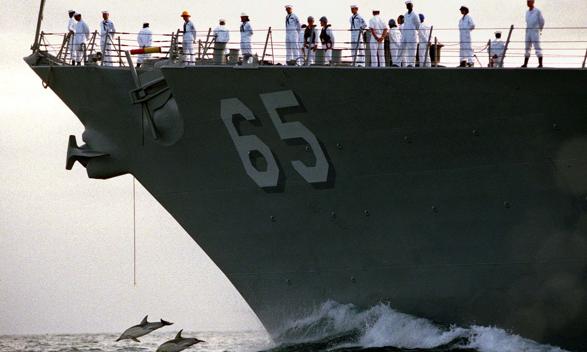
Missile destroyer
Guangzhou launches an air-defense missile during a military exercise in
the water area near south China’s Hainan Island and Xisha islands on
July 8, 2016
Xinhua News Agency—Xinhua News Agency/Getty Images
Xinhua News Agency—Xinhua News Agency/Getty Images
Ultimately, it’s not even clear what the nine-dash line means to China.
Is it all water within the boundary or all territorial features? For the average Chinese, every drop of sea within the dashes is clearly China’s.
“The discontinuous line,” says Wang, “means the national border on the sea.” The geographer clarifies further.
“The dash lines mean the ocean, islands and reefs all belong to China and that China has sovereign rights,” she says.
“But it’s discontinuous, meaning that other countries can pass through the lines freely.”
Certainly, some of China’s actions seem to support that definition of the line.
In 2012, a fleet of Chinese maritime surveillance cutters patrolled the South China Sea in what was dubbed a “regular rights defense patrol.” A Chinese state TV crew was brought along for part of the ride.
Andrew Chubb, a Ph.D.
student at University of Western Australia who studies Chinese policy on the South China Sea, noted in his research that the route that Chinese ships took, which was documented on state TV, echoed the nine-dash line.
Chinese audiences would be left with the natural impression that the dotted demarcation was the extent of Chinese sovereignty.
In addition, as recently as 2012, Chinese boats cut seismic cables used for energy exploration by Vietnam.
The cable-cutting occurred near the western extent of the nine-dash line, again suggesting that these waters were China’s.
But international maritime law, which was formed after China’s dotted line was created, doesn’t see it that way.
Even if China controlled every contested Spratly rock and reef — currently Beijing holds a minority of all Spratly features, which they have built into artificial islands — the law of the sea would not give China rights to all waters within the nine-dash line.
Back in 2014, Wu Shichun, the influential head of the Chinese government-funded National Institute for South China Sea Studies, told TIME that the nine-dash line did not represent a blanket claim to all maritime space.
“China has never claimed all waters in the U-shaped line,” he said.
“From the historical archives from Taiwan and China, it’s clear that the line shows ownership of insular features within the U-shaped line.” A government statement reacting to the July 12 award may hint that official policy agrees that the line denotes all territory within the dotted demarcation, not all waters.
Either way, the fact that ambiguity remains at all proves the complicated legacy of the nine-dash line.
Meanwhile, tensions remain in the wake of the July 12 ruling.
The Philippines, which lodged the case against China with the international tribunal in 2013, had said it would dispatch a former President to Beijing to negotiate on South China Sea issues.
But on Tuesday Philippine Foreign Minister Perfecto Yasay told local broadcaster ABS-CBN that Beijing’s wish not to discuss the international tribunal’s judgment made bilateral talks tough.
A day earlier, Beijing announced another set of military drills in the South China Sea, following live-fire action earlier in the month.
China is cordoning off part of the South China Sea for war games from July 19 to 21.
Entrance to these waters by foreign ships, China’s Maritime Safety Administration said, will be “prohibited.”
Links :
- GeoGarage blog : What the South China Sea ruling means for the world / Philippines vs China: Why a South China Sea ruling may change Asia / China’s ‘Historic Rights’ in the South China Sea: Made in America?
- The Diplomat : The South China Sea Is Really a Fishery Dispute
- Quartz : The line on a 70-year-old map that threatens to set off a war in East Asia
- NYTimes : Philippines v. China: Q. and A. on South China Sea Case / Ruling on South China Sea Nears in a Case Beijing Has Tried to Ignore
Tuesday, July 19, 2016
US Navy banned from using sonar that harms dolphins and walruses
Dolphins in front of US Navy ship Benfold. Marine life will now be protected from Navy sonar.
Photograph: Mark Wilson/Reuters
From BBC
Low-frequency sonar used for training and testing can injure whales and other marine life, and disrupt their feeding and mating
A federal appeals court ruled on Friday that the US Navy was wrongly allowed to use sonar in the nation’s oceans that could harm whales and other marine life.
The ninth circuit court of appeals reversed a lower court decision upholding approval granted in 2012 for the Navy to use low-frequency sonar for training, testing and routine operations.
The five-year approval covered peacetime operations in the Pacific, Atlantic and Indian Oceans and the Mediterranean Sea.
The appellate panel sent the matter back to the lower court for further proceedings.
A message seeking comment from representatives of the US Pacific Fleet in Honolulu was not immediately returned.
Sonar, used to detect submarines, can injure whales, seals, dolphins and walruses and disrupt their feeding and mating.
The 2012 rules adopted by the National Marine Fisheries Service permitted Navy sonar use to affect about 30 whales and two dozen pinnipeds; marine mammals with front and rear flippers such as seals and sea lions, each year.
The Navy was required to shut down or delay sonar use if a marine mammal was detected near the ship. Loud sonar pulses also were banned near coastlines and in certain protected waters.
Environmental groups, led by the Natural Resources Defense Council, filed a lawsuit in San Francisco in 2012, arguing the approval violated the Marine Mammal Protection Act.
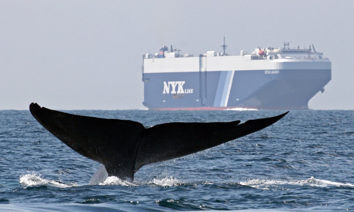
A blue whale swims near a cargo ship in the Santa Barbara Channel off the California coast. Photograph: John Calambokidis/AP/Cascadia Research
The appellate court ruled 3-0 that the approval rules failed to meet a section of the protection act requiring peacetime oceanic programs to have “the least practicable adverse impact on marine mammals”.
“We have every reason to believe that the Navy has been deliberate and thoughtful in its plans to follow NMFS guidelines and limit unnecessary harassment and harm to marine mammals,” the appellate ruling said.
However, the panel concluded the fisheries service “did not give adequate protection to areas of the world’s oceans flagged by its own experts as biologically important,” according to a summary accompanying the court’s decision.
“The result is that a meaningful proportion of the world’s marine mammal habitat is under-protected,” according to the decision.
Links :
- Scientific America : Does Military Sonar Kill Marine Wildlife?
- The Guardian : Whales to gain 'long-sought protections' as navy limits sonar use, activists say / Navy sonar devices could signal threat to whales and other marine animals / 'A deaf whale is a dead whale': US navy sonars could be cause of strandings / Why are so many whales dying on California's shores?
- CS Monitor : Why a federal court ruled against the US Navy, in favor of whales
- Wired : The sea will get a lot quieter without the Navy's whale-killing sonar
- GeoGarage blog : Boom! There goes the neighborhood / Stemming the rise of a sea of noise / Slew of whale deaths mystifies scientists / Noise pollution could frustrate fish /
Monday, July 18, 2016
Tackling illegal fishing in western Africa could create 300,000 jobs
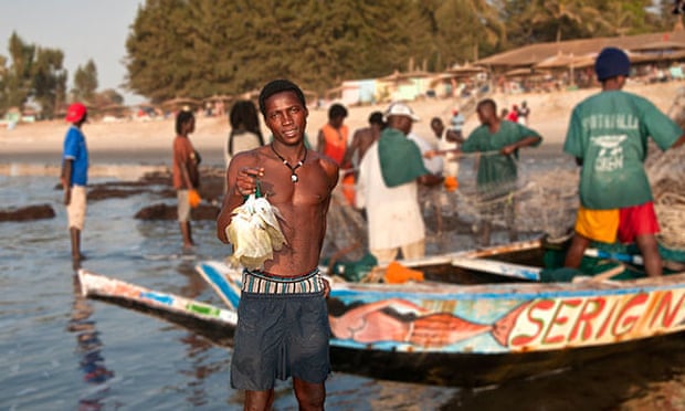
A fisherman with a catch of angelfish, near Serrekunda in the Gambia.
The report says if regional governments build up fish processing
industries and indigenous fishing fleets, they could generate $3.3bn.
Photograph: Alamy
From The Guardian by Jo Griffin
Overseas Development Institute report says crackdown on illegal fishing, and building up national fleets, could generate billions of dollars for the region
If governments in western Africa could end illegal fishing by foreign
commercial vessels and build up national fleets and processing
industries, they could generate billions of dollars in extra wealth and
create around 300,000 jobs, according to a new report (pdf).
The devastating, social, economic and human consequences of overfishing in western Africa’s coastal waters have been well documented but the report, Western Africa’s Missing Fish, by the Overseas Development Institute and Spanish investigative journalists porCausa, lays bare the extent of lost opportunities across countries including Senegal, Mauritania, Liberia, Ghana and Sierra Leone.
The devastating, social, economic and human consequences of overfishing in western Africa’s coastal waters have been well documented but the report, Western Africa’s Missing Fish, by the Overseas Development Institute and Spanish investigative journalists porCausa, lays bare the extent of lost opportunities across countries including Senegal, Mauritania, Liberia, Ghana and Sierra Leone.
“The scale of the losses is enormous. Instead of jobs and
development, the livelihoods of artisanal fishers are being decimated by
foreign fishing fleets, which operate virtually unchecked,” says
Alfonso Daniels, lead author of the report, which presents new evidence
of the extent and pattern of illegal, unreported and unregulated fishing
(IUU) in the region – a global “epicentre” of overfishing.


For the first time, researchers used detailed satellite and tracking
data to analyse the two main practices of IUU fishing: the activities of
reefers – large-scale commercial vessels that receive and freeze fish
at sea – and the transportation of fish in large refrigerated containers
that are subject to less strict reporting requirements.
In 2013, they followed reefers off the coast of western Africa and found vessels from China, Holland and South Korea operating there, with fish exported globally.
Among the 35 reefers operating in the region that year, routes were consistent with the transfer of catches from fishing vessels to reefers, including inside the exclusive fishing waters of Senegal and Ivory Coast, countries that have banned ship-to-ship transfers of catches.

Daniels says that 84% of illegal fish is taken out of the region in this way, making it hard to stop illegally caught fish entering the global supply chain.
“Container ships are ignored,” he says.
“Whether willingly or not, the industry has found a way to take out fish under the radar.”
The report says that a “crisis of global governance on the world’s oceans” has meant that international efforts to prevent the plunder of marine resources are likely to fail.
Daniels says it is essential to address all parts of the chain, highlighting three measures to combat IUU fishing: a ban on transferring fish at sea, strengthening regulations, and investment in patrols in “hot spots” of IUU fishing.
Artisanal fishers are at the frontline of the crisis.
Usmane Kpanabum, a fisherman on the island of Sherbro off Sierra Leone, says his nets were slashed by South Korean trawlers that fish inside the five-mile coastal zone reserved for artisanal fishers.
Sierra Leone had just two coastguard boats to patrol its entire coastline in 2013.
If regional governments end illegal fishing and build up fish processing industries and indigenous fishing fleets, they could generate $3.3bn (£2.5bn), eight times the $400m they currently raise by selling foreign rights, says the report.
It could also have a significant impact on food security, improving the diet and nutrition of people in the region as more households would consume fish protein normally exported by foreign vessels.
Daniels says: “We have a situation not only of missed opportunity but where resources are being exhausted very quickly – Nigeria and Senegal have very little left at all.”
According to one previous estimate, more than half of the stocks in the stretch of coast from Senegal to Nigeria alone have been overfished, with IUU fishing believed to account for between one third and half of the total catch. In 2012, according to data from USAid, Senegal was losing around $300m due to IUU fishing – equivalent to 2% of GDP.
“There are several global epicentres of overfishing – including the Pacific and South America – but western Africa is one of the worst because of the impact of overfishing on problems such as the drugs trade, organised crime and illegal migration,” Daniels says.
Links :
In 2013, they followed reefers off the coast of western Africa and found vessels from China, Holland and South Korea operating there, with fish exported globally.
Among the 35 reefers operating in the region that year, routes were consistent with the transfer of catches from fishing vessels to reefers, including inside the exclusive fishing waters of Senegal and Ivory Coast, countries that have banned ship-to-ship transfers of catches.
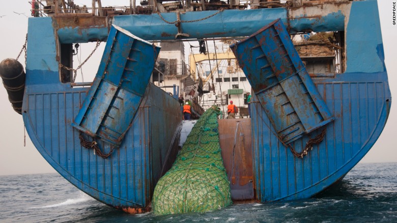
The 120 m long Russian super trawler trawler Mikhail Verbitsky ishing in West Africa waters. Foreign fleets are plundering the West African waters while fish stocks are diminishing
Bycatch like dolphins end up dead or dying in the giant nets of the super trawler
The
tracking data also revealed the extent of IUU fishing via transfers on
to container ships.Daniels says that 84% of illegal fish is taken out of the region in this way, making it hard to stop illegally caught fish entering the global supply chain.
“Container ships are ignored,” he says.
“Whether willingly or not, the industry has found a way to take out fish under the radar.”
The report says that a “crisis of global governance on the world’s oceans” has meant that international efforts to prevent the plunder of marine resources are likely to fail.
Daniels says it is essential to address all parts of the chain, highlighting three measures to combat IUU fishing: a ban on transferring fish at sea, strengthening regulations, and investment in patrols in “hot spots” of IUU fishing.
Artisanal fishers are at the frontline of the crisis.
Usmane Kpanabum, a fisherman on the island of Sherbro off Sierra Leone, says his nets were slashed by South Korean trawlers that fish inside the five-mile coastal zone reserved for artisanal fishers.
Sierra Leone had just two coastguard boats to patrol its entire coastline in 2013.
If regional governments end illegal fishing and build up fish processing industries and indigenous fishing fleets, they could generate $3.3bn (£2.5bn), eight times the $400m they currently raise by selling foreign rights, says the report.
It could also have a significant impact on food security, improving the diet and nutrition of people in the region as more households would consume fish protein normally exported by foreign vessels.
Daniels says: “We have a situation not only of missed opportunity but where resources are being exhausted very quickly – Nigeria and Senegal have very little left at all.”
According to one previous estimate, more than half of the stocks in the stretch of coast from Senegal to Nigeria alone have been overfished, with IUU fishing believed to account for between one third and half of the total catch. In 2012, according to data from USAid, Senegal was losing around $300m due to IUU fishing – equivalent to 2% of GDP.
“There are several global epicentres of overfishing – including the Pacific and South America – but western Africa is one of the worst because of the impact of overfishing on problems such as the drugs trade, organised crime and illegal migration,” Daniels says.
Links :
Sunday, July 17, 2016
Navy ships in the storm
D-646 Latouche-Treville, French fregate for anti-submarine warfare,
class F-70 Georges Leygues, 139 m length, 4910 tons vessel, with 240 crew members.
A part of this movie is visible in the movie "Oceans" of Jacques Perrin & Jacques Cluzaud.
A part of this movie is visible in the movie "Oceans" of Jacques Perrin & Jacques Cluzaud.
The RNZN vessel HMNZS Otago sailing through a storm in the Southern Ocean.
20m swells with 80KMph winds.
Subscribe to:
Posts (Atom)