Saturday, October 16, 2021

British Isles & misc. (UKHO) update in the GeoGarage platform

1835
 
UKHO nautical maps in the GeoGarage platform for British islands in the West Indies


Old chart of the Antilles or Caribs islands with the Virgin islands
by L.S. de la Rochette (1784)

Hell or High Seas - Official Trailer


HELL OR HIGH SEAS follows U.S. Navy veteran Taylor Grieger and writer Stephen O’Shea as they embark on the adventure of a lifetime — sailing around Cape Horn, the world’s most treacherous ocean waters.
The documentary is a moving portrait of a veteran using his own painful journey with PTSD to find healing for himself, and to pave a smoother path for veterans returning to civilian life.
HELL OR HIGH SEAS is an adventure film with a deep, universal message about perseverance and hope.
 

Every day in America over 20 veterans die of suicide.
It’s a dark, ironic fact that the transition for military personnel into civilian life can be more deadly than combat itself.

A portion of the proceeds from ticket sales will go to american odysseus sailing foundation, the tax exempt 501(c)3 co-founded by Taylor Grieger.
Their mission is providing assistance and relief to service members and veterans with PTSD through adventure therapy with offshore sailing expeditions. (see https://www.amodsailing.org/)

Friday, October 15, 2021

When seas and maps impact geostrategy and the future

 
 From RedAnalysis by Héléne Lavoix

Sovereign territory is key for power and for activities.
This principle will most probably remain more or less so in the foreseeable future.
Thus, what is the territory over which each state is sovereign?
What is the size of each of these territories?
And where are these territories located?
How does the geographical international world look like?

We think we, of course, know the answers to these questions.
Certainly, for example, the largest states must be Russia, the U.S., Canada and China.
Certainly, European states are strong only in geographical Europe.
But what if these answers were wrong? What if the real international and global world within which we live and will live looked quite differently from the representations to which we are most often used?

Using maps, this article focuses on a representation of the world that is coherent with reality.
It insists on the importance to consider the seas and sovereignty over maritime territories globally rather than to look solely at outdated representations centred on landmass.
It highlights geo-strategic consequences of this “revised” territorial representation of the world and underlines a few recommendations.

Classical representation of the world

Representation of the world, maps and strategy

Representations of the world embodied as maps define how we think, plan ahead, act.

Representations influence how we think strategically.
If we want to design and implement successful strategies, then we need to make sure our mental representations are close enough to reality.

Our conceptions of the geographical space within which we live will constrain and enable what we deem as possible, our vision and objectives, how we design and carry out strategies to realise our objectives, planning and implementation of policies.

They are keys in terms of envisioning global power interplay, which country we think has most chances to win or lose, to be a superpower or not, to be part significantly of the international order or not.
They are keys in terms of defense and security, from classical defence and war to planning ahead for threats stemming from climate change, biodiversity loss and more generally ecosystems’ changes.
The are key in economic terms.
They are key in terms of deciding where to locate factories and offices.
They are key in terms of logistics.

Changing our representation of space may change what we do and how we conceptualise ourselves, as well as our relationship to others.

For example, modern geography and especially mapping has been critical in the development of nation-ness and the idea of a nation.
It has been no less critical in allowing for the imposition of the principles of the modern nation-state worldwide – i.e.
sovereignty, territoriality and independence (see with a related bibliography Hélène Lavoix, “The Power of Maps“, The Red Team Analysis Society, 2012).

A classical focus on landmass

One of the most ancient maps of the world, a Mappa Mundi, is the Tabula Peutingeriana, possibly a medieval copy of a Roman map (ca.
250) created around 1250 (Ulrich Harsch Bibliotheca Augustana).

It looks as illustrated in the images below:


Tabula Peutingeriana, 1-4th century CE.
Facsimile edition by Konrad Miller, 1887/1888, Public Domain via Wikimedia Commons – Click on image to access on ZoomViewer.

The focus is on major landmass displaying road networks, cities, some geographical features such as rivers and mountains, with nonetheless known seas and islands, as shown here with Corsica and Sardinia (first image).
The political centredness of Rome is also highlighted (second image).

Currently, the 21st century Mappa Mundi to which we are used looks as below:
 
This is a typical political map of the world.
The source of the map, the CIA World Factbook, tells us that it is indeed the most common and widespread perception of the world in terms international security, international relations, and geopolitics, as well as economic activity.

With this type of maps, we focus on known land-mass, with small and tiny islands powered over oceans.
We also look at distance between sovereign, independent and territorial states.
We are interested in borders and especially contested boundaries.

In case of disputes on boundaries, then we focus on more precise and detailed maps, such as the one below for the potential for conflict in the East and South China Sea.

Similar maps are drawn according to domains and interests, from energy to mining, through military commands and armies.

Whatever the outlook, the framework for the representation is landmass first, accessorily, unfortunately or even unimportantly in the middle of oceans, handled through ports and transportation lanes.

Seeing the Seas and under the Seas

Updating maps


Now, this focus on main continental landmasses gives us a wrong picture of reality.
Two fundamental elements are lacking: exclusive economic zones (EEZ) and continental shelf, which led to claims for extended continental shelf (ECS).

Maybe the easiest way to understand what the EEZ and the continental shelf represent in geopolitical terms is first to imagine the earth without the oceans.
Emerged lands (the current landmasses) would then appear as the top of more or less large mountains and plateaux.
What we perceive usually as a state’s territory would be located starting from the top of these mountains or plateaux to the coast line (or land boundary as agreed with neighbours).
Another slice of territory would be located around the country and spread over 12 nautical miles (the territorial sea).
Then another much larger territory would be located within the next “boundary” line, at 200 nautical miles (the EEZ) from the coastline.
Finally, a last slice of territory would spread, if it exists, over 360 nautical miles of the continental shelf to which the mountain or plateau belongs, starting from the coast line, or if the continental shelf is smaller than 350 nautical miles, then its end.*
Jean-Benoît Bouron provides a very clear graphic showing these different zones in « Mesurer les Zones Économiques Exclusives », Géoconfluences, mars 2017

All the ground within the last ECS revisited boundary is under the sovereign jurisdiction of the state, more or less as for usual emerged landmass*, which includes all exploitation rights.

Then you can fill in again the depth with the water of the seas and oceans.
All the water that is within the 200 nautical miles is under the sovereign juridiction of the state.

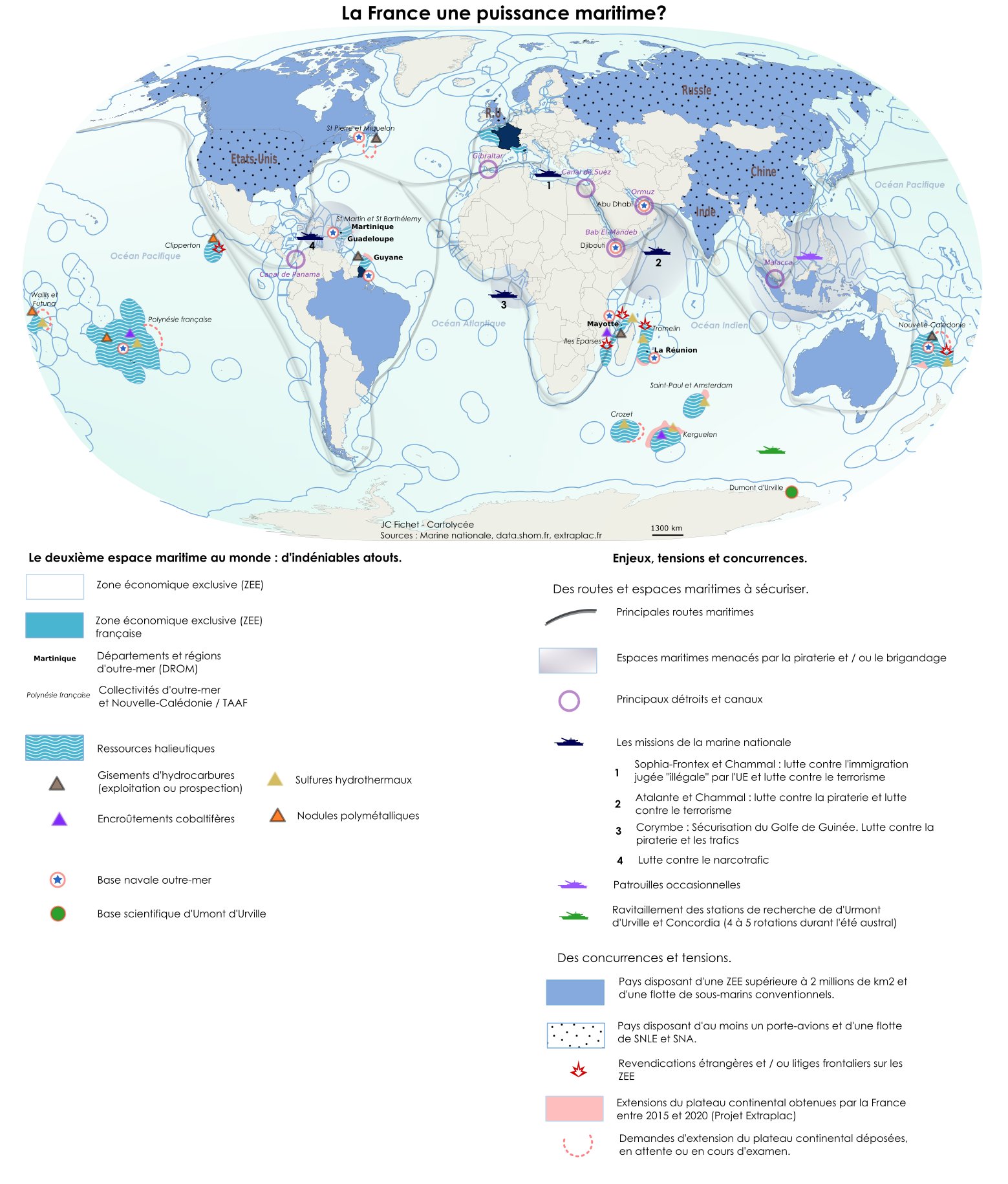
For the European Union, for example, the right map with the EEZs looks like the image below (access through the European Marine Observation and Data Network (EMODnet) portal).

EMODnet Map of the EU countries plus the UK and their EEZ – 13 November 2020 – Click on image to access interactive map

Yet, even this much better map is not completely correct.
We must add to it the extended continental shelf (ECS) claims each country had to submit by 13 May 2009 (for more details, Helene Lavoix, “The Deep-Sea Resources Brief“, updated 5 January 2018).
We can see what these claims cover on the picture below.
 

If you click on an area, on the interactive mapping website by GRID Arendal, then you will see which country laid claim to this area, as well as the status of the claim.

Now, if we combine all maps, we obtain a representation of the world that is very different indeed from what we are used to (note that Antarctica territories are still missing from these maps**).

Which international actors are truly global powers?

The only truly geographically global power is the European Union, as long as it remains united.
The loss of Great Britain was a serious blow in geopolitical terms, with the loss of South Atlantic supremacy.
Comparatively, the U.S. is a Pacific power.
Furthermore, the EU’s total EEZs represent 20,07 million km2, while the next power, the U.S., only totals 12,17 million km2 (Jean-Benoît Bouron, “Mesurer les Zones Économiques Exclusives“, Géoconfluences, 23 Mars 2017).

First image: EMODnet Map of the EU countries plus the UK and their EEZ – 13 November 2020.
 

Second image: NOAA’s Exclusive Economic Zone (EEZ) of the United States and affiliated islands (dark blue).

 
China Exclusive Economic Zones and disputes by ASDFGHJ, CC BY-SA 3.0, via Wikimedia Commons

China remains within its traditional boundaries, to which the disputed South and East China Sea zones must be added.
The absence of maritime and continental shelf possessions for China contributes strongly to explain its extremely active multinational and international vision as well as its related efforts with the International Seabed Authority (ISA), regarding the Arctic and Antarctica (see Helene Lavoix, “The Ultimate Key Technologies of the Future (3) – Extreme Environments“, The Red Team Analysis Society, June 2021; Jean-Michel Valantin, “Antarctic China (2) – China’s Planetary Game” and “Antarctic China (1): Strategies for a Very Cold Place“, 31 May & 28 June 2021, as well as Jean Michel Valantin articles on the Arctic, The Red Team Analysis Society).
If China wants to be a global power with a corresponding geographical basis, it has no other choice.
China’s space strategy may also be seen within this framework as, by completely displacing the “theatre of operations”, and making it planetary and not only earthly, then China could make partly obsolete its worldwide lack of presence on the globe.

Changing a component of power: a different ranking relative to territory

With the new global map revisited to add the EEZs and ECSs, the real size and potential power of states changes.


Global territory per international actor (in millions of km2) – ranked per EEZs and ECS and ranked per total territory – Sources: mainly Bouron, “Mesurer les Zones Économiques Exclusives“, Ibid; USGS and NOAA; Portail national des limites maritimes; Wikipedia.

Russia is the largest international actor, closely followed the EU.
The U.S. arrives next.
China is far beyond.
India is even further away.
Australia then Canada, however, arrive right after the U.S.
Yet, Canada EEZs is exclusively located around its landmass, nonetheless making it an Arctic power.
Australia has, thanks to the sea and its EEZs, a substantial presence in the Indian Ocean.

In terms of states, despite small initial landmasses, France becomes the 7th largest country in the world – on a par with China – while New Zealand and the UK respectively become the 9th and 10th largest countries.
Germany ranks far below and was added only for the sake of comparison.

France, indeed, has the second largest maritime territory after the U.S. and this territory is spread principally in the Pacific and Indian Oceans.
The U.S. is absent from the Indian Ocean.
Even though it is not visible on the maps, the U.S. is an Arctic power but not an Antarctic one, while France is an Antarctic power but not and Arctic one.
The UK with also a global presence is especially strong in the South Atlantic Ocean.


The U.S. EEZs territory (left) and France 2014 EEZs and ECS territory (right)
Left: NOAA’s Exclusive Economic Zone (EEZ) of the United States and affiliated islands (dark blue).

Taking stock of the maritime dimension of territory and power


Hence, it would be logical, strategically, that France, the UK and the EU conceptualise their power in terms of territory and notably maritime territory.
This may come easily to the UK considering its history, but may be much harder for the EU and France.

On the contrary, China, and in a lesser way Russia, are fundamentally land-based powers, which, of course, is far from stopping them to develop maritime power (Valantin, Arctic articles, Ibid.).
Yet, in the case of China, it has to do so without “points d’appuis”, hence the critical importance of the maritime part of the Chinese Belt and Road, that supplements China’s lack of substantial maritime territory (Valantin, “Militarizing the Maritime New Silk Road“, The Red Team Analysis Society, 3 April 2017).

The importance of this maritime territory seems to start being considered at the EU level, as, for example, the “EU extend[ed] trade defence rules to continental shelf and exclusive economic zones of Member States” on 3rd July 2019.
Yet trade is only a part of the instruments of power.
Further detailed research and assessment would be needed here.

A difficult adaptation: the complex case of France?


If we look, as another example, at the official 2019 French Army document, France and Security in the Indo-Pacific, it appears quite clearly that old representations are hard-lived.
It seems to be difficult to fully start thinking in terms of global territoriality, as shown in the first map of the gallery below.

This does not mean that all French actors have an outdated vision, as shown for example, by the Ifremer, the report of the French Economic Social and Environmental Council (CESE) mentioned below, or the more recent portail national des limites maritimes, using only the maps they provide as weak signals (second, third and fourth map in the gallery below).

First image: French Army, France and Security in the Indo-Pacific, 2019 p.3
 
Second Image: Ifremer
 
Third image: SHOM interactive map, access from portail national des limites maritimes

Fourth Image: Gérard Grignon, “Extension of the Continental shelf beyond 200 nautical miles:an asset for France“, Economic Social and Environmental Council, 2013, p.74

Yet, be it for lack of understanding, vision or something else, for unknown reasons, in 2009, France withdrew the filing of the preliminary information regarding the ECS of Clipperton, thus abandoning or postponing the assertion of sovereign rights.
This was done under President Sarkozy, of the Republican Party (right, LR).
This abandon was denounced, for example, by the special report of the French Economic Social and Environmental Council (CESE), which is only consultative (Gérard Grignon, “Extension of the Continental shelf beyond 200 nautical miles:an asset for France“, 2013, pp.
25 & 33, 125-129), as: “an unacceptable abandoning of the sovereignty of France over its legitimate pretentions.”Grignon, “Extension of the Continental shelf beyond 200 nautical miles:an asset for France“, p.33

Obviously, nothing has been done to remedy this incredible action and submit the claim as recommended, as the official website of the national maritime limits does not list any ECS for Clipperton (portail national des limites maritimes, “tableau des superficies”, access 15 sept 2021), despite French rights, the existence of resources such as hydrothermal sulfur (Grignon, ibid.
p.141 using Ifremer, note N°3 Ocean Mineral Resources, September 21, 2012), and possibly polymetallic nodules.

In general, considering the overall French territory, it looks like the French ECS are particularly small.
Indeed, for example, apart from Clipperton, other territories were not followed up and no preliminary information was filed for them during the Sarkozy and then Holland Presidency (Grignon, Ibid., p.61, 125-133).
As a whole, it would seem that 725.297 km2 of ECS have been recognised (“tableau des superficies”), when the CESE calculates that 2.510.544 km2 could be claimed (Grignon, pp.134-135).
2.5 million km2 correspond to 3,7 times the French emerged territory.

The diversity of visions – and actions – of the various French actors should not be a surprise and has long presided over the destiny of the country, notably when exploration and overseas territory are concerned (from Jacques Cartier and the Nouvelle France, to the “Loss of India” – actually trade posts – under Louis XV, through settlements in the French American territories, support of the Americans in the War of Independence, the necessity to go against Napoleon III for a global vision, or the refusal to rely on and completely consider Protectorates and Colonies during World War II, despite demands by the people of these territories – e.g. among others, Raoul Girardet, L’Idée Coloniale en France, (Paris, Hachette/Pluriel, [1972], 1978); Catherine Coquery-Vidrovitch, « La colonisation française 1931-1939;» in Histoire de La France Coloniale : III.
Le Déclin, ed. Vol.3 (Paris: Armand Colin, Agora, 1991); Helene Lavoix, ‘Nationalism’ and ‘genocide’ : the construction of nation-ness, authority, and opposition – the case of Cambodia (1861-1979) – PhD Thesis – School of Oriental and African Studies, University of London, 2005).

Yet, France is de facto the first power in the Indian Ocean.
It is also a very strong power in the Pacific possibly on a par with the United States (for the Southern part).

Interestingly, if we think about the old 19th century idea of François Guizot, the policy of “points d’appuis” across the globe allowing for force’s projection (and initially coal and other supplies for steamboats in the then competition with the UK, see Lavoix, Nationalism and Genocide, Ibid.), then the French Caribbean Islands and Clipperton are important locations to reach French areas in the Pacific.

Improbable neighbours

Another consequence of looking globally at the territory of international actors is to become fully aware of the existence of “improbable” neighbours.
For example, Australia and France are neighbours, around the Kerguelen islands and New Caledonia.
Australia and Norway similarly are neighbours (North of Antarctica).
These relationships exist also considering neighbourhood on Antarctica**.

This entails possibly thinking differently about alliances or to the least strong cooperation.

Why does that matter and recommendations

Among the crucial factors that will shape our future, we find climate change and biodiversity loss, or more largely ecosystems’ changes, and ressources (including energy) rarefaction, all leading us to increasingly use new, more extreme, territories.

One such extreme territory is the deep-sea, which involves knowing it, protecting it yet using it.
As a result, being able to exploit in a truly sustainable way the abyss, to then transport the obtained ressources where they are needed, to police the related areas and secure them will be of primary importance.

Being sovereign over such territories, which are de facto maritime, will be a factor of wealth and survival.
Being able to use these territories strategically is no less important, as shown by the Chinese efforts and successes in this field (e.g. Lavoix, “The Ultimate Key Technologies…”, Ibid.).

The links between the global maritime domain and space should be neither forgotten nor underestimated as space is key for navigation and communications for example.

Halieutic resources and their preservation, of course, should not be forgotten.

Groups of interested players, be they public, private or mix, should move forward to invest and develop sustainable capabilities and management of flows in the EEZs and ECS, more particularly in the deep-sea.
They should include start-ups and make sure innovation and multi-disciplinary research is fully included.
They may have to apply lobbying pressure on states.
This strategy could be particularly useful when or if official rulers and administrations happily practice neglect to the point of default.

Companies should rethink their strategies to consider how the world truly looks like and how related alliances and tensions may evolve and impact their activity.

States, diplomats and armies should make sure they have and will have the means to ensure the security of the territory under their sovereignty, especially considering the increasingly tense context and the rising challenges of the future.

Note

* We are here adopting a geopolitical approach, not an international law dispute vision.
Our purpose is not discuss the differences between sovereignty and boundaries related to territorial sea, EEZs, preeminence of the law of the sea, etc, nor the relationships between power, force, international relations, international law, international system, etc.

**”As the Washington Treaty of 1 December 1959 froze all claims to the Antarctic continent, possessor states, such as France, cannot exercise sovereignty or jurisdiction over the waters beyond the Antarctic territory they claim.
Requests to extend the continental shelf are also suspended.
As a result, the maritime spaces relating to Adelie Land are not included in the maritime spaces currently in force for France.” (Limites maritimes, Tableau des superficies, 2021).

Links : 

Thursday, October 14, 2021

The global transition to remote and autonomous operations

 
From Hydro by By Hugh Parker, Ross Macfarlane

The Benefits and Challenges Facing the Maritime Industry

Over the next five years, we will witness a significant reduction in the maritime industry’s reliance on larger vessels, as the focus on compact and agile uncrewed surface vessels (USVs) increases and a wider transition towards remote marine operations continues to gather momentum.
The benefits as well as the legal framework challenges of remote and autonomous operations will have a profound impact on the energy and maritime industries.

The ability to plan, manage and monitor offshore projects, and to maintain assets and infrastructure, through remote operations and autonomous capabilities is increasingly critical within the energy and maritime industries.
Through their flexible deployment and good connectivity with onshore remote operations centres (ROCs), USVs can acquire data to support these objectives faster than ever before.

 Safety and Sustainability

USVs also provide significant benefits when it comes to safety: used as force multipliers alongside crewed parent vessels, they allow crewed vessels to remain at a safe distance from assets such as wind turbines and avoid unnecessary risk for those onboard.
This has the potential to translate into a 100% reduction in human exposure to hazardous offshore environments where, rather than transmitting their situational awareness and vessel status data to personnel onboard parent vessels, USVs will ultimately be solely controlled from the safety of an onshore location, such as one of Fugro’s ROCs.

Additionally, clients are increasingly looking to reduce the environmental impact of their operations in line with the zero emission targets presented in the UK government’s Maritime 2050 route map.
The global transition towards remote and autonomous working will help to reduce the greenhouse gases emitted by the maritime industry, as hybrid USVs consume up to 95% less fuel than conventional vessels.

However, despite these obvious advantages, as innovation outpaces regulation, the legal framework in which USVs operate remains a challenge.

Fugro’s Blue Shadow next-generation uncrewed surface vehicle.

Maritime Legislation for Uncrewed Vessels

The safety of life at sea is a core value of all maritime authorities around the globe.
The current maritime legislation has been carefully crafted over many decades with the safety of the mariner at its core; however, we are now transitioning to a future where vessels no longer have a mariner onboard, which creates a gap in the current legislation.
This poses an interesting problem of how to legislate for both crewed and uncrewed vessels operating side by side.
 
Safety Standards

As is the case with the rapid development of any new technology, it is challenging to create fixed ruling that leaves room for constant innovation and the continued progression of new methods of working.

One of the first attempts at this will be the revised workboat code being developed by the Maritime and Coastguard Agency (MCA), expected by the start of 2022.
The workboat code document will apply to commercial vessels up to 24m long and include new regulations covering MASS.
This reflects the fact that many USVs in development or already operating are smaller than their conventional crewed vessel counterparts.

The focus of this forthcoming legislation is expected to shift from the safety of crew onboard to the safety of other seagoing vessels and the wider environment.
This is particularly the case with the adoption and creation of rules to ensure that vessels can maintain an awareness of their surroundings and take appropriate action to prevent incidents.
At present, vessels have two clear ways to achieve this: through remote monitoring and control by a human operator and/or using onboard situational awareness and collision avoidance software.
 
Fugro’s Blue Shadow hydrographic survey operations displayed onscreen in a Fugro remote operations centre.
 
Trusting Uncrewed and Remote Technology

Much like self-driving cars, societal acceptance is crucial to the adoption of these new technologies, where they are expected to work correctly 100% of the time with no margin for error.
While collision avoidance systems are being developed to improve USVs’ navigation safety, the question of public trust remains: can we trust a USV to be left alone at sea and respond as a conventional crewed vessel would? If not, how do we ensure that the people who are remotely monitoring and controlling them have the same situational awareness as they would onboard?

The regulations which eventually come into force will need to balance the developmental freedom to truly revolutionize the way in which the maritime industry operates with the ongoing protection of those human lives still at sea, while also improving safety standards and protecting the environment.

Trialled and Tested USV Operations

Fugro’s Blue Shadow is a globally deployed, next-generation 9m autonomous and uncrewed hydrographic survey platform delivering nearshore seabed insights faster.
Part of Fugro’s overall hydrographic solution, Blue Shadow is one of many from its fleet of USVs ranging from 9m to 24m, within the suite of remote and autonomous capabilities that are more sustainable when compared to conventional vessels.
Sustainability of USVs is an advantage built into their design concept from the beginning: vessels whose function is purely to survey and acquire data can of course be much smaller than traditional vessels, which are designed to transport people and cargo.

Fugro recently completed its first remotely operated hydrographic survey using Blue Shadow to capture hydrographic and bathymetric data to support safe navigation, nautical charting, marine site characterization and resource management activities.

Fugro’s Blue Shadow performing its autonomous survey trials off the coast of Portchester, UK.

Executed during challenging environmental conditions, including waves of up to 2m, the compact, wave-piercing design of the USV allowed it to acquire high-quality data in conditions that would have been unworkable for conventional vessels.
This lengthening of the potential work window increases surety of project delivery, providing more opportunities throughout the year to acquire much-needed data for clients.

The survey operations also achieved, depending on the sea conditions, a 61% to 96% reduction in greenhouse gas emissions through significantly reduced fuel consumption.
Moreover, the innovative collision avoidance and advanced spatial awareness technology built into the Blue Shadow ensured its autonomous operations met the highest safety standards.

What Next?

While the development and deployment of new remote and autonomous solutions progress, the legal framework will continue to play an essential role in influencing the design and engineering parameters for next-generation USVs and other MASS.
We are currently in a critical phase of the global transition to remote and autonomous maritime operations and it is essential that the legal framework is swiftly put in place to allow these technologies to flourish.

 
Fugro’s Blue Essence USV, part of Fugro’s remote and autonomous operations solution, carrying out inspection operations.

Wednesday, October 13, 2021

The harsh history behind the internet's favorite sea shanty


From Mashable by Chris Taylor
 
No, "tonguing" doesn't mean what you think it means.

It's easy to see why "Soon May the Wellerman Come" became TikTok's first viral hit of 2021.
This jaunty 19th century earworm, sung so earnestly by a postman with a thick Scottish brogue, is perfect for remixing with multiple layers.
Though musicologists will tell you it's technically a ballad, "Wellerman" fits our concept of a sea shanty as snugly as a cable-knit sweater.
We've spent months in isolation, yearning for the day when this ship of weirdness will reach the port of normalcy.

But at the risk of raining on the internet's fun, the cheeriness of the tune is deceptive.
"Wellerman" reveals a harsh history of exploitation and cruelty, hiding in plain sight in the lyrics.
For example, the original singers' awaited "sugar and tea and rum" not because they loved candy, caffeine, and booze, but because they generally didn't get actual money: This was their pay packet.
And as hilarious as "tonguing" sounds to us, it describes one of the worst jobs ever invented — stripping the blubber out of a rotting whale carcass.

No wonder they wanted to take their leave and go.

The right whale, or the whale right now
 
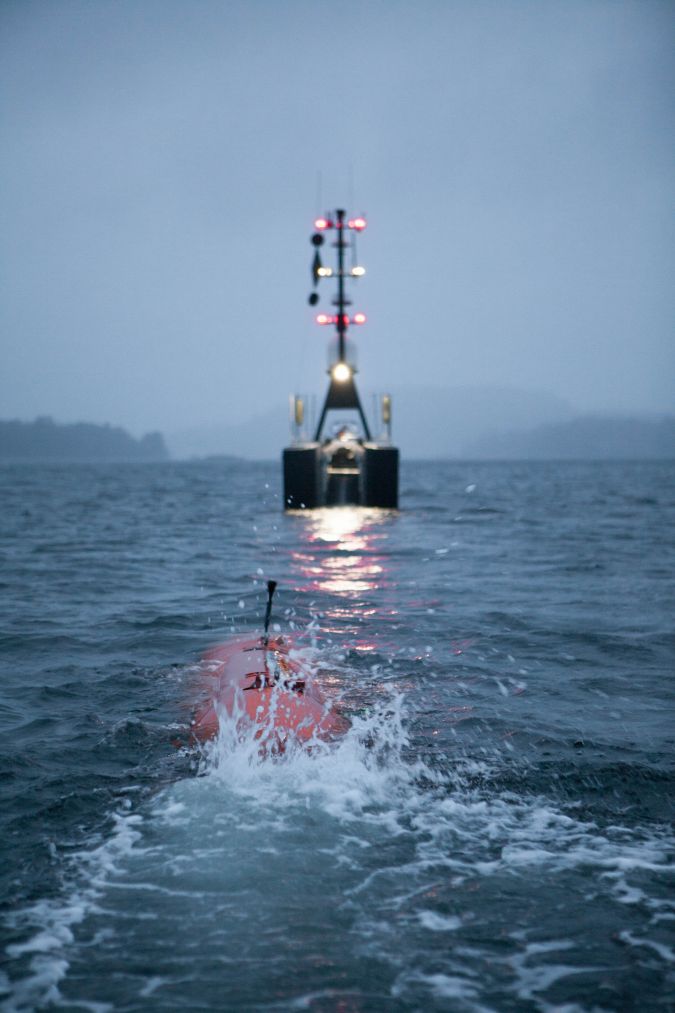
''South Sea Whale Fishery,' painted in 1836 — when the Wellerman company was most active.
Credit: Print Collector / Getty Images
 
It's hard to believe, in our everything-is-archived world, that such a catchy tune as "Wellerman" might easily have been lost forever.
The song hails from New Zealand, likely some time in the 1830s.
We only have it because a 1960s musician named Neil Colquhoun was in the habit of recording old folk tunes; this was one he heard from a man in his 80s, who'd learned it from his uncle.

Colquhoun first published the song in 1965; by sheer coincidence, this was the same year New Zealand banned whaling.

Thus ended a horrific form of hunting that began in 1791, when British ships bringing convicts to Australia started harpooning whales near New Zealand on their way home.
(New Zealand's original settlers, the Maori, generally used whales that had been washed ashore rather than hunting them.)

Whale oil was a foul-smelling thing, but its usefulness in lamps, candles, soap, food and industrial lubricants outweighed the odor.
Whale bone was a sturdy material that could be thinly sliced and was used in brushes, corsets and especially umbrellas, before steel was a thing.
In short, there was money in them thar whales.
 
 
An illustration for an 1845 book shows all the ways whale oil was used.
Credit: SSPL Via Getty Images
 
Anyone who has read Herman Melville's Moby-Dick (1851), or was forced to read it at school, has learned that whale oil was as "rare as the milk of queens."
They also learned that whalers could literally be driven mad or drowned in pursuit of their giant quarry, and that New Zealand — mentioned a dozen times in Melville's book — was one of the centers of this global trade.

Here in the 1830s, dozens of lonely whaling station teams hunted southern right whales, which could yield 75 barrels of whale oil each.

The prices varied wildly from place to place, but in the U.S.
that much whale oil could net you at least $150,000 in today's money, not counting the whale bone.
That might help explain why the Billy o' Tea, the ship in the verses of "Wellerman," spent two weeks looking for a right whale and more than 40 days trying to kill the thing.

The Billy o' Tea — a "Billy" is a pot used for heating water — appears to be a fictional ship.

The listener is left to wonder whether this is a whaler's tall tale or, like Moby-Dick, a metaphor for human hubris.
Can a captain really spend 40 days getting pulled around by a whale his crew harpooned, losing four other vessels in the process?
Melville's Captain Ahab might have something to say about that.

When the Wellerman came

 
An engraving of life aboard a whaling ship, circa 1850 Credit: Fotosearch / Getty Images
 
So who was the Wellerman in the song, then, who arrives like a deus ex machina to supply the Billy o' Tea?
Why, he was literally the man from Weller — as in Weller Bros., one of the earliest whaling and trading companies to make a fortune in New Zealand and Australia.
Mellville actually worked on one of their ships in 1842, meaning that for one brief moment the author of Moby-Dick was a Weller man.

Company founder Joseph Weller was an expat Brit, a wealthy landowner from Kent.
He took his family to Australia in the hope it would improve his health; he had a lifelong struggle with tuberculosis.
On arrival, Weller and his three sons got into the trading game, and in 1831 they founded remote Otago whaling station on New Zealand's south island.
If there was any particular location for a group of shanty singers to be doing the hated tonguing, it was Otago.

The Wellers were doing a brisk trade, bringing in about 300 right whales per season and employing 80 people.
But for as little as they paid in actual wages, they also paid a high personal price.
In 1832 a Maori raiding party burned down Otago station for reasons unknown — possibly because the Wellers hadn't consulted the locals before blundering onto their land — and holding Joseph's son Edward hostage until dad paid up.
Joseph rebuilt Otago in 1833, but lost his battle with tuberculosis there in 1835; his body was shipped back to Sydney in a cask of rum.
(Presumably that was one cask not later used to pay his employees.)

Edward Weller left Otago in 1840, never to return.
The number of right whales began to decline.
The Weller company went bankrupt shortly afterwards.
Otago continued as a supply station for other whaling companies, which had started to shift focus to more lucrative and long-distance hunts for sperm whales.
Edward reportedly died in a flood in New South Wales in 1893.
 
What was left of their greedy, invasive, abusive, whale-slaughtering enterprise?Merely a song, invented by their roughneck employees, passed down generation to generation.
"Wellerman" was recorded a dozen times since Colquhoun captured the song — most recently by The Longest Johns, whose version inspired the TikTok perfomance.
No doubt the Wellers would be delighted to know their name has been immortalized on a global network where songs are shared and re-sung.

But context is key.
So the next time you hit play on a version of "Wellerman," take a moment to remember the gruesome whale oil business it describes.
Perhaps one day shanties will be sung about modern-day oil companies that are even more damaging to the environment; a rapidly warming planet would certainly be better off if they would take their leave and go.

Links :

Tuesday, October 12, 2021

France’s new marine protection strategy should include stronger safeguards, experts say


Right: SHOM map 2014 – used on the “Tableau des superficies” webpage, Limites Maritimes 

From Pew by Jérôme Petit

In January, France unveiled its new global marine conservation strategy with a goal of protecting 30% of its waters by 2022; a third of that would be shielded by “high protections” under the plan, meaning that extractive activities would not be allowed in the areas.
Achieving these goals would be a major step forward for global ocean health because France has the world’s second-largest exclusive economic zone (EEZ)—covering 11,691,000 square kilometers (4,514,000 square miles)—largely because of its numerous overseas territories, including French Polynesia, New Caledonia, and the French Southern and Antarctic Lands (TAAF)

Leading up to France’s announcement, the Pew Bertarelli Ocean Legacy Project partnered with the International Union for Conservation of Nature (IUCN) French Committee to bring experts and stakeholders together in a series of online conferences exploring the need for, and benefits and importance of, high marine protection—which should be the government’s focus now, given that it has almost achieved the 30% goal.


Marine protected areas benefit ocean health and coastal communities

The first conference of this series, held in September 2020, featured 12 French experts focused on ocean health and effective approaches to conserving biodiversity, including establishing fully safeguarded, well-managed marine protected areas (MPAs).

The experts explained that MPAs, specifically those with a high level of protection, provide measurable benefits to marine ecosystems and surrounding communities.
Such MPAs can protect seagrasses and reefs, which buffer coastal communities from the full impact of waves and safeguard coastlines from erosion.
They also can promote carbon sequestration by preserving mangrove forests, which can absorb at least three times as much carbon as terrestrial tropical forests.

In addition, conference participants highlighted how MPAs can benefit local economies. Research proves that fish are larger and more numerous inside an MPA than outside.
As fish populations mature and grow, they spill over into fishing grounds, generating greater catch and income for fisherman. MPAs can also help generate significant revenue related to tourism. 
 
French Military Presence in the Indo-Pacific

The importance of high protection

The potential benefits of MPAs can be fully realized only if those areas are large and highly protected, according to experts.
Although 23.5% of French maritime waters are designated as MPAs, some still permit activities such as industrial fishing that undermine the intended conservation benefits of the protections.
According to a recent paper published in the journal Marine Policy, less than 2% of French waters are fully or highly protected, and 80% of that total is concentrated in a single overseas territory: TAAF.

Panelists at another conference, held online in November 2020, noted that these highly protected waters are predominantly located in overseas territories with little traffic and less exposure to human pressures and therefore indicate a “lack of representativeness” of France’s marine habitats worldwide.
During the conference, experts recommended that France establish more highly protected MPAs—that better represent key habitats—across its territorial waters.

As part of its strategy announcement, France pledged to develop three three-year action plans with input from its overseas territories.
The first of these plans was released in January, and the implementation of this plan provides France with an opportunity to enhance its marine protection in order to deliver significant ecological benefits.
This would require it to create highly protected MPAs that restrict all extractive and damaging activities, such as industrial fishing.

A global call for action

The best available science tells us that we need to protect at least 30% of the ocean to conserve biodiversity and ecosystems, improve long-term food security, and protect ocean-based livelihoods.
Today, more than 70 countries, including France, have publicly committed to achieve this goal by 2030, and more than 100 countries are united in their support for a global biodiversity target to significantly increase the protection and conservation of the planet’s ocean over the next decade.
France plays a leading role in promoting the 30% global target through the High Ambition Coalition.
With this global momentum, countries can deliver a post-2020 framework at the 15th Conference of the Parties to the Convention on Biological Diversity later this year; that framework should include a robust ocean target that calls for effective marine protections, with the focus on areas important for biodiversity and ecosystem services.

Monday, October 11, 2021

AI breakthroughs could improve weather forecasts : finding patterns in the data

Oscar Wong / Getty Images

From LifeWire by Sascha Brodsky

Key Takeaways
  • Artificial intelligence is combing through vast amounts of data to create more accurate weather forecasts.
  • The UK’s weather service has developed an AI tool that can accurately predict the likelihood of rain in the next 90 minutes.
  • Spire Global is one company that’s already using AI to enhance forecasts.

Your next weather update may be coming to you courtesy of artificial intelligence (AI).

Britain's national weather service has developed an AI tool that it claims can accurately predict the likelihood of rain in the next 90 minutes.
Making accurate weather predictions is a challenging problem that has resisted millenniums of effort. But researchers hope AI could revolutionize weather forecasting.

"Any industry that is weather-sensitive is looking into ways to use AI to improve safety and operations," Renny Vandewege, the vice president of weather operations at data analytics company DTN, told Lifewire in an email interview. 
"For example, utilities are using AI to identify and predict grid resiliency and potential outages." 
 

Today's weather forecasts all come from the most powerful computers on Earth, and they can't even tell you accurately if it's going to rain or not tomorrow.
They rely on millions of calculations with heavy mathematic algorithms to try to predict the weather. What if we could replace all this with artificial intelligence by analyzing weather patterns of the past 40 years to predict the future?
This would not have been imaginable 10 years ago, and we are not far from it today. 
 
Nowcasting Rain

London is known for gloomy skies, but at least you may have a better warning when sprinkles start. Working with the UK's national weather service, AI company DeepMind has developed a deep-learning tool called DGMR for forecasting.

Experts judged DGMR's forecasts to be the best across a range of factors—including its predictions of the location, extent, movement, and intensity of the rain—89% of the time, according to a paper recently published in the journal Nature.
The company calls the technique "nowcasting" because it's so timely.

"We use an approach known as generative modeling to make detailed and plausible predictions of future radar based on past radar," DeepMind wrote on its website
"Conceptually, this is a problem of generating radar movies. With such methods, we can both accurately capture large-scale events, while also generating many alternative rain scenarios (known as ensemble predictions), allowing rainfall uncertainty to be explored."

Appu Shaji, an AI scientist not involved in the DeepMind study, called the company's work "impressive" in an email interview with Lifewire.
"That being said, these works are still in their infancy, and we should expect to see considerable advancement in accuracy and forecasting possibilities in the coming years," he added.

Predicting Chaos

Weather is a chaotic process that's difficult to predict with precision.
"Advanced weather models and technology, like AI, improve forecasting to help us to better plan, prepare and lessen the impact of weather events," Vandewege said.
"As weather events become more frequent and extreme, accurate forecasts with a longer lead time mean businesses, communities and the public have more time and more information to make better decisions."

Weather simulations are currently run using computer models, Vikram Saletore, an AI expert at Intel, told Lifewire in an email interview.
But, he said, weather models need to be run frequently as the environment changes for accurate forecasting.
"AI dramatically improves weather forecasting by enabling and accelerating significantly these simulation environments to take in massive amounts of historical models with the current environment as input and run predictions on potential outcomes," Saletore added.

Spire Global is one company that's already using AI programs to enhance forecasts.
The PredictWind program provides wind forecasts to maritime and leisure sporting users by processing satellite data with computer algorithms.
"Climate change is increasing the likelihood of extreme weather and global operations open businesses to the threat of weather disruptions anywhere in the world," Matthew Lennie, an AI expert Spire Global, told Lifewire in an email interview.

Computing power has been a bottleneck for weather forecasting.
As a result, some of the most powerful supercomputers have been built specifically to crunch forecasting numbers.


Ryan McGinnis / Getty Images

"AI has an amazing chance to reduce this dependency on powerful engines and potentially run these models to get as good as or better results with significantly less computational load," Shaji said.
"Deep learning doesn't try to solve these formulae directly, but predicts them based on observable patterns."

The AI method is similar to how stock market investors watch patterns over long periods, Shaji pointed out. "Deep learning has more accuracy," he added.
"The predictive accuracy and capability of models will only become better in the future."
 

Sunday, October 10, 2021

How deep ocean really go


From Nerdist by Matthew Hart 
 
Despite the fact that we’re all inundated with stories of oceans and lakes both adventurous and horrific, “the depths,” so to speak, all tend to blend together.
In a new video, animator and YouTuber MetaBallStudios helps to tease apart the dark waters of the world. And if you think you know how deep the ocean really is, you may need to think again.
MetaBallStudios (or MBS), a Spanish animator whose real is name is Alvaro Gracia Montoya, recently posted the above video to his channel.
For those unfamiliar, MBS has cranked out countless animated comparison videos before.
The animator has, for example, compared the sizes of various spaceships from Star Wars.
As well as how big various comets in our solar system are.
In this comparison, MBS goes for depth instead of his usual size angle.
The video begins with the Sea of Azov, which is in Eastern Europe and has an average depth of only 23 feet.
From there, MBS slowly works down into deeper and deeper bodies of water, providing familiar structures and event sites as references.
At about 90 seconds in, for example, MBS shows that the average depth of the Timor Sea is 270 feet deeper than the Eiffel Tower is tall.
(That would be over 1,060 feet.) 

A visualization of the depths of various bodies of water referenced with well-known structures, such as the Eiffel Tower.MetaBallStudios
As the comparison continues, the depths become more and more dizzying.
The average depths of the Argentine Sea, the Arctic Ocean, and the Black Sea all cluster around 4,000 feet deep.
Which seems deep, until the animation pulls back, revealing depths that grow to tens of thousands of feet.
With the Mediterranean really bringing the “abyss staring into you” factor to 11 with a depth of more than 17,000 feet.

The Atlantic Ocean crushes that depth, however, deepening in(?) at a whopping 27,000 feet deep.
For reference, that’s approximately as deep as Mount Everest is tall.


The deepest floor of any ocean on Earth, however, is the Mariana Trench, which is in the western Pacific Ocean.
The trench, which is home to alien crustaceans and sounds that will send chills down your spine, is an astounding 36,000 feet deep.
What’s just as astounding, however, is that explorers have visited there and sadly found plastic waste

Links :