How cute this baby skates look at the legs.😍😍😍😍😍 pic.twitter.com/BLK0Y1ZdX4
— the observer (@Omar1983175) August 20, 2020
Saturday, October 18, 2025
How cute this baby skates look at the legs
Friday, October 17, 2025
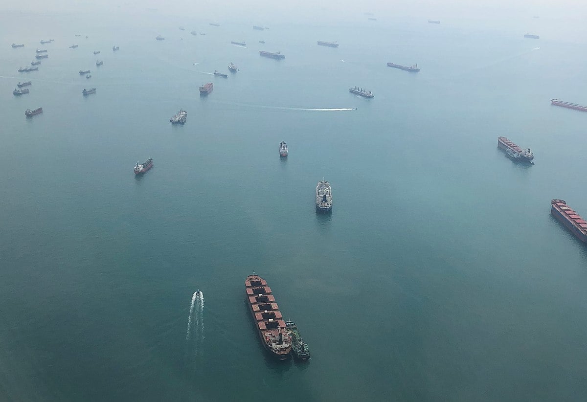
Calls for vigilance due to rise in piracy and robberies in 2025
 Arrests near the Singapore Strait contributed to a marked decrease in robberies (file photo)
From Maritime Executive
The merchant shipping industry continues to face the threats of piracy and armed robberies, but the ICC International Maritime Bureau, in its latest report, also points to progress, including the arrest of two gangs that were terrorizing the area around the Singapore Strait.
With a slight increase in activity and areas of higher concern, the group says it must reinforce the need for vigilance and that there is no room for complacency.
The ICC International Maritime Bureau (IMB) admits the world is far from winning the war on piracy and armed robberies despite the continued overall reduction in global incident levels over the years.
Between January to September 2025, it recorded a total of 116 incidents, up from 79 in the same period last year.
The incidents are the highest reported nine-month figures since 2021.
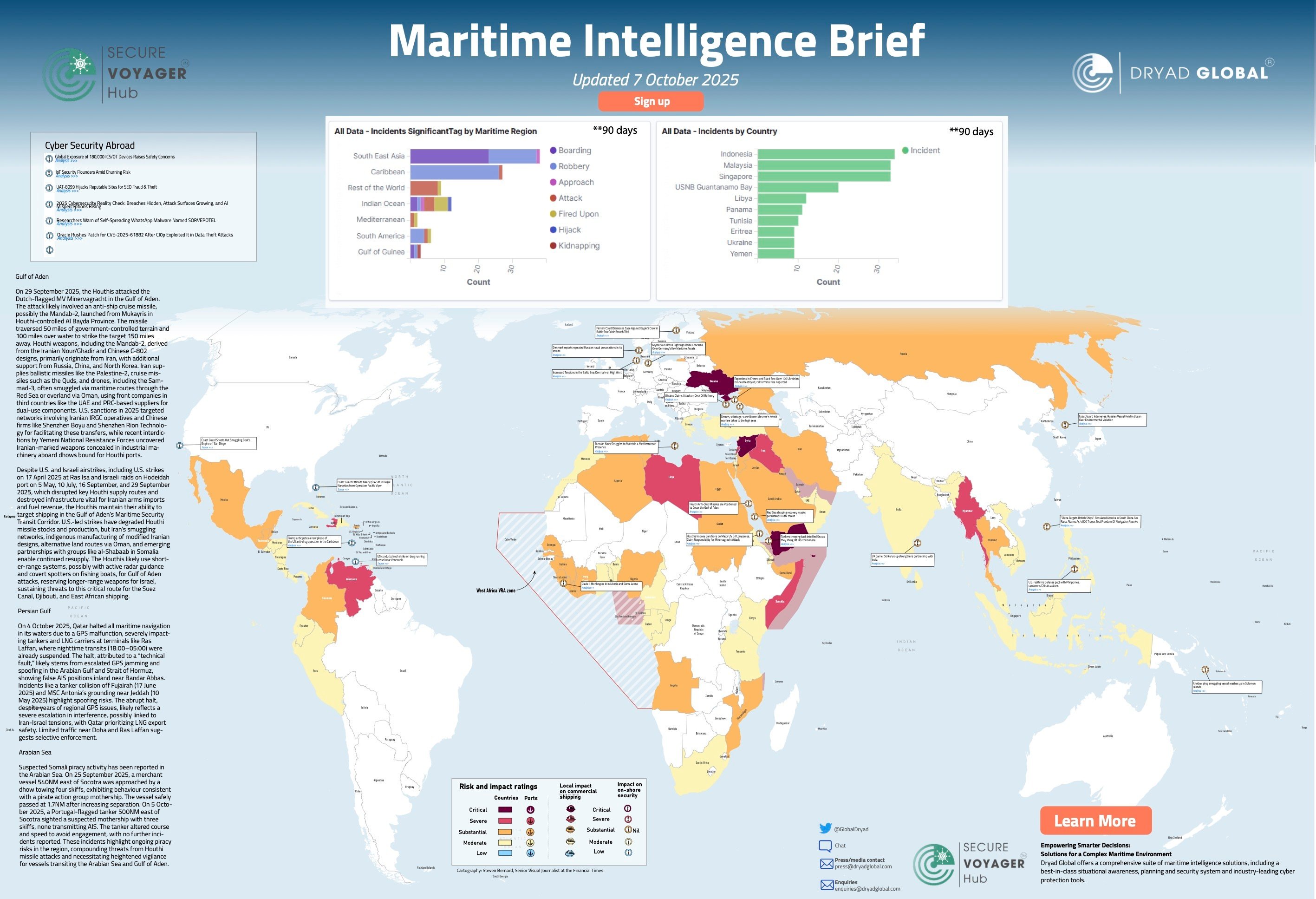
The fact that criminal gangs remain a threat to shipping is evident considering that 102 vessels reported being boarded, while nine faced attempted boardings, four were hijacked, and one was fired upon.
Notably, in nearly all the incidents, perpetrators successfully gained access to the vessel, with most boarding incidents occurring at night.
Another concern is the high number of incidents where weapons were involved.
In the first nine months of this year, 55 percent of the reports cited the use of a weapon, with 33 percent of the cases involving guns.
IMB highlights this is the highest level since 2017.
IMB and its Piracy Reporting Center continue to focus on the dangers in the Singapore Straits, which handles nearly a third of global trade flows, and continues to be the hotspot of piracy and armed robberies.
Of all the reported incidents, a total of 73 were in the Singapore Straits, the highest number recorded since 1991.
The high rate of incidents at the busy strait, however, has forced authorities into action.
In July, the Indonesian Marine Police (IMP) carried out a crackdown on organized gangs targeting international vessels, leading to the arrest of 11 suspected pirates in the Riau Islands.
There is finally some hope in the area which has been plagued by boardings and robberies in recent years.
The IMB reports that there has been a “marked reduction in incidents” since the arrests in July.

The report also shows that the Gulf of Guinea, which a few years ago had replaced waters near Somalia as the epicenter of piracy, continues to record low numbers of incidents.
In the nine-month period, 15 incidents were reported compared to 12 in the same period of 2024.
Of these, 10 were armed robberies, and the remaining five were piracy incidents.
IMB highlights that the low numbers do not mean an absence of risk to crews.
In the Gulf of Guinea waters, 14 crew were kidnapped while perpetrators continue to demonstrate the capability to target vessels out at sea.
A case in point was in late August when the Danish-flagged product tanker Hafnia Phoenix with a crew of 13 was boarded off the coast of Ghana.
The enhanced surveillance and collaborations in the fight against piracy have improved in waters off Somalia and the Gulf of Aden.
During the third quarter of the year, no incident was reported, a development that was, however, in part also attributed to the prevailing southwest monsoon conditions.
In the first half, 26 crewmembers were taken hostage, but the events were mostly in coastal waters and involved two fishing vessels and one dhow.
“This is an important time to reinforce the need for vigilance.
There can be no room for complacency, and globally, vessel owners and operators are encouraged to follow industry guidelines and report incidents promptly,” said IBM Director Michael Howlett.
Links :
- ModernDiplomacy : Piracy in the Gulf of Guinea: Maritime Crime and Insecury
- Safety4Sea : IMB: Optimism despite rise in incidents in the first nine months of 2025
- Dryad :
Wednesday, October 15, 2025
Bridging land and sea: FMSDI and the future of coastal insight
 Courtesy GNFMS / NOAA
From Maritime Executive by Dr. Ingo Simonis
Dr. Ingo Simonis, Ph.D. is CTO of the Open Geospatial Consortium (OGC).
To learn more, access pilot results, or explore how your organization can participate in the next phase, visit ogc.org or contact OGC directly to join the dialogue.
Coasts are places of convergence.
They are where ships meet ports, where cities meet tides, and where human infrastructure must coexist with dynamic natural forces.
They are also where our data systems often fall apart.
On land, survey agencies and municipalities maintain elevation models, cadastral records, and infrastructure maps.
At sea, hydrographic offices chart depths, currents, and hazards.
Each operates in its own world, with its own standards, coordinate systems, and governance.
At the shoreline—the “white ribbon,” as some hydrographers call it—these systems collide.
The result is uncertainty precisely where clarity matters most.
For centuries, mariners coped with charts that ended at the low-water mark, while land surveyors mapped shorelines as static boundaries.
In the age of climate change and globalized trade, those divisions no longer suffice.
Storm surges, rising seas, and shifting coastlines demand integrated models of land and sea.
Ports and shipping require seamless data to manage traffic, dredging, and safety.
Coastal communities need accurate, shared information to plan resilience.
This is the story of the Federated Marine Spatial Data Infrastructure (FMSDI) initiative: a global effort to connect the worlds of land and sea through shared data, common standards, and federated access.
The White Ribbon Problem
The “white ribbon” is more than a metaphor.
It is the literal band on digital maps where land-based elevation models and marine bathymetric charts fail to meet.
This happens because each domain uses different vertical reference systems—mean sea level on land, chart datums at sea.
Coordinate systems don’t always align.
Surveys occur at different times and resolutions.
For a port authority, this might mean not knowing exactly where dredging is needed.
For a shipping company, it can mean uncertainty about safe approach depths.
For emergency planners, it can mean blind spots in storm surge modeling.
For coastal managers, it complicates habitat mapping and climate resilience planning.
In short: fragmented data creates fragmented decisions.
A Federated Approach
Rather than building one massive system, OGC and its partners launched FMSDI in 2021 to test a federated model.
The premise is simple: agencies and operators should keep control of their own data but connect them through open standards so they can be discovered, accessed, and integrated in real time.
By Phase 5 in 2024, the initiative had grown into a collaboration among the UK Hydrographic Office, NOAA, the National Geospatial-Intelligence Agency, Natural Resources Canada, Singapore Land Authority and Maritime Port Authority, Esri, Hexagon, TCarta, and others.
The pilots aimed to do two things: develop best practices for interoperability at the land–sea interface; and demonstrate live, technical solutions that show how integration can work in practice.
Demonstrations that Made it Real
The pilots produced three compelling technology showcases.
Compusult built unified operational pictures that combined terrestrial elevation, bathymetry, and tidal data.
In The Solent (UK) and Chesapeake Bay (USA), the system showed how vessels could be routed based on current tidal conditions and combined topographic-bathymetric models.
The result: safer, more efficient navigation in dynamic coastal environments.
Pangaea Innovations applied a 4D Discrete Global Grid System (DGGS) to index data across space and time.
This approach allowed direct queries across terrestrial and marine datasets without complex harmonization.
For port operations, this means infrastructure and navigation data can be analyzed together through a single framework.
TCarta demonstrated satellite-derived shoreline monitoring.
By tying vectors to tidal states, they produced near real-time updates of where the coast actually is.
This provides a scalable, cost-effective way to keep intertidal models current—a critical need as sea-level rise accelerates shoreline change.
All demonstrations were anchored in OGC APIs and IHO S-100 standards, ensuring that the work could plug into existing GIS and marine information systems.
Why This Matters for the Maritime World
These demonstrations may sound technical, but their implications are far-reaching:Navigation and safety: Accurate land–sea integration reduces risks for vessels in port approaches and congested waters.
Port and logistics efficiency: Seamless data improves berth planning, dredging strategies, and overall traffic management.
Resilience and climate adaptation: Harmonized vertical datums allow storm surge and flood risk models to extend across the true land–sea continuum.
Environmental stewardship: Integrated datasets enable monitoring of coastal habitats, wetlands, and marine protected areas.
Security and defense: Cross-border data sharing improves situational awareness in contested or vulnerable intertidal zones.
Insurance and finance: Trusted, authoritative datasets underpin risk models that affect insurance premiums and infrastructure investment.
Five Best Practices Emerging from FMSDI
The pilots distilled their lessons into five principles that any maritime nation or organization can adopt:Unified geospatial reference: Aligning datums across land and sea eliminates discontinuities that undermine models.
FAIR data principles: Ensuring data is Findable, Accessible, Interoperable, and Reusable supports discovery and automation.
Mind the gap: Filling intertidal data voids through targeted surveys or satellite-derived products ensures continuity.
Coordinated governance: Frameworks like IGIF-Hydro clarify responsibilities and reduce duplication across agencies.
Scalable resolution management: Integrating high-resolution data where needed, without losing regional context, balances detail with scale.
International Momentum
FMSDI is not operating in a vacuum.
It aligns with global efforts such as:UN-GGIM’s Integrated Geospatial Information Framework (IGIF): A strategic guide developed by the United Nations to help countries strengthen their geospatial information management and infrastructure for sustainable development.
IGIF-Hydro: A thematic extension of IGIF focused specifically on water-related geospatial data, supporting integrated water resource management and decision-making across sectors.
IHO’s S-100 framework: Modernizing the way marine data is structured and exchanged, from navigation to tides to marine protected areas.
Regional initiatives in Europe, Asia, and the Americas: Where federated SDIs are becoming part of digital public infrastructure.
By grounding its work in frameworks like IGIF, IGIF-Hydro, and S-100, FMSDI ensures that the solutions tested locally can scale internationally and contribute directly to global goals for resilience, sustainability, and efficiency.
Looking Ahead
The shoreline is not static, and neither is the FMSDI initiative.
The next phases will focus on:Operationalizing vertical datum transformation services.
Expanding satellite-based shoreline and bathymetry monitoring.
Broader adoption of DGGS indexing for multi-domain integration.
Deeper engagement with port authorities, coastal states, and private operators.
Integration on different concepts of real-world objects (a lighthouse is an obstacle when in flight, a navigation help when on ship, and possibly a tourist attraction while on land)
The vision is clear: a global fabric of federated marine and terrestrial datasets that can support resilience, efficiency, and innovation.
A Coastline of Possibility
The white ribbon once represented a barrier.
Today, it represents an opportunity.
By bridging land and sea through federated approaches, we can transform fragmented data into a foundation for smarter navigation, safer coasts, and more resilient communities.
The Federated Marine Spatial Data Infrastructure initiative shows that technical obstacles can be overcome, agencies and companies can collaborate, and open standards can provide the glue.
For the maritime sector, this is more than a technical breakthrough.
It is a path to greater trust, efficiency, and foresight in a world where the coast is never still.
The Open Geospatial Consortium (OGC) continues to coordinate this work with hydrographic offices, space agencies, research institutions, and industry partners worldwide.
Links :

Lidar + Sonar = a revolution in seafloor mapping

Seamless topobathymetric Lidar digital elevation model (DEM) of an area of the Dry Tortugas National Park, Florida.

From Hydro by Ryan Cross, Dave Neff, Karen Hart
How the ambitious Florida Seafloor Mapping Initiative is setting the standard for our understanding of coastal environments
Beneath the sunlit waves of Florida lies an intricate underwater world that few have seen but many depend on.
Through the Florida Seafloor Mapping Initiative, Woolpert and partners are capturing this hidden landscape in unprecedented detail.
Using aircraft, ships and uncrewed vessels equipped with Lidar and sonar, they have mapped tens of thousands of square kilometres despite hurricanes and rough seas.
The resulting seafloor model will enhance navigation, habitat protection and coastal resilience while deepening understanding of Florida’s marine environment.
There are few regions of the United States as defined by or as dependent upon their coastal waters as the state of Florida.
Florida’s annual maritime economy is valued at US$402 billion, incorporating tourism, commerce and trade.
Cruise and cargo operations alone contribute to at least US$117 billion and over 900,000 direct and indirect jobs across the state, according to the Florida Ports Council.
Florida Seafloor Mapping Initiative
At a time when shifting climate patterns are affecting coastal regions around the world in myriad, often undetermined ways, and with a need to understand coastal vulnerabilities and other issues, Woolpert and partners embarked on the ambitious Florida Seafloor Mapping Initiative (FSMI), a multifaceted project led by the Florida Department of Environmental Protection (FDEP) to create a high-resolution seafloor surface model of the state’s coastal waters.
Deploying aircraft, ships and uncrewed surface vessels, the team mapped tens of thousands of square kilometres of the Florida coast.
Using Lidar sensors from the air and multibeam sonar technology from the sea – a combination of technologies deployed at a scale not previously attempted – the team has generated highly-detailed imaging of Florida’s underwater environment.
Since October 2023, experts and technicians have faced down hurricanes, freezing winds and weeks spent on ships far offshore.
But with significant and wide-ranging project outcomes expected, the effort is deemed worth the challenges.
Slated for hosting on the website of the National Centers for Environmental Informationand the Florida Geographic Information Office, this sophisticated mapping database will help with habitat and ecological management, promote methods for safer navigation and assist with fishery and other resource management efforts.
It is also expected to aid with coastal resilience efforts, the identification of precise locations of shipwrecks and other popular underwater tourism sites, and provide a host of yet-to-be-determined returns.
What is more, making the data available to the public allows anyone – from recreational fishers to curious students anywhere in the world – to see and experience exactly what lies underneath Florida’s coastline.

RV Thunder is owned and operated by Woolpert.
This purpose-built vessel surveyed in both the Gulf of Mexico and on the Atlantic coast.
Mapping from the air
Woolpert’s topographic-bathymetric (topobathy) Lidar mapping efforts focus on FSMI’s Region 3, covering nearly 27,000 square kilometres off the southern coast of Florida, including the Florida Keys, the remote Dry Tortugas National Park and parts of the south-east Gulf of Mexico.
Since October 2023, four aircraft equipped with Leica Chiroptera-5 and HawkEye-5 sensors have conducted five mapping expeditions, collecting seafloor data to depths of 48 metres.
With priorities centred on shallow-water regions, the Lidar imaging has uncovered submerged channels critical for navigation, blue holes and carbonate banks.
It also generated detailed datasets for habitat systems and environments crucial to the health of manatee populations, coral reefs and mangrove forests in places such as the Big Sable Creek mangrove forest ecosystem in the Everglades National Park.
The ability of topobathy Lidar to collect huge swathes of data using a single flight line makes it a key tool for completing projects quickly and accurately.
 Bathymetric data acquired in 85 metre depths off Florida’s Atlantic coast.
The dunes are about 15 metres tall and continue for hundreds of kilometres.
And from the sea
Deploying up to eight boats ranging from 50 to 130 feet in size, the sonar surveying operations have covered nearly 18,000 square kilometres of seafloor in areas within regions 1 (north-east Florida), 5 (the Big Bend region) and 6 (the Florida Panhandle).
To improve the efficiency of the sonar operation, sections of the mapping process saw a dual-head setup on ships that supported a wide swathe of surveying, boosting coverage areas to five times the water depth in shallow water.
Woolpert exclusively uses R2Sonic (2022, 2024 and 2026) multibeam sonar surveying technology systems that can scan more than 200 metres beneath the surface of the sea.
While some of these coastal areas have been mapped in the past, this project stands out in its ability to deliver higher resolution and image quality than achieved before to establish a new level of clarity.
And while past projects have relied on autonomous vessel mapping, this FSMI project is the first of its scale to deploy over-the-horizon autonomous systems, meaning these vessels are operating uncrewed and alone in open water.
Satellite technologies such as Starlink enable surveyors and technicians to be on the vessels, virtually.
Project technicians remotely operated the autonomous, uncrewed vessel MC29, which can work for weeks at a time using Starlink communications.
Woolpert installed its equipment on the 29-foot-long vessel, which was operated by Chance Maritime pilots, to map around 2,150 square kilometres of seafloor.
This remote MC29 operation made the project far more efficient than when requiring a traditional crewed vessel.
Woolpert deployed a ‘follow the sun’ system, whereby data collectors based in South Carolina, Alaska, Australia and Ireland maintained a 24-hour system to collect data remotely and in real time.
 More than a dozen wrecks were mapped in the bathymetric data including this 170 by 70-metre floating drydock that was sunk in 40 metres of water to create an artificial reef.
Far-reaching goals
The scale and ambition of the FSMI project served up challenges and opportunities to propel new advancements in equal measure.
In similar projects, mapping is conducted typically only during the summer months, when surface water conditions are relatively calm.
This short mapping season could have turned the FSMI project into a three- to five-year endeavour, but the Woolpert team kept working throughout the year, often in challenging sea conditions.
Florida’s coastal waters routinely face weather not seen in most other parts of the world.
For five months of the year, hurricanes can be a major concern for residents, businesses and tourists.
Allocating vessels while attempting to anticipate storm tracks as they rolled through western Florida during the second half of 2024 proved to be a challenge for project managers working to keep the FSMI project on track.
In October 2024, Hurricane Milton, the strongest tropical cyclone to have occurred anywhere in the world that year, wreaked havoc across Florida’s peninsular coast in the form of widespread damage and fatalities.
Another daunting challenge was managing and processing petabytes of data.
Data collection from multiple sensors on up to four different aircraft could have resulted in significant variances in datasets.
To remedy this potential obstacle, the Woolpert team automated much of the offshore processing, including such processes as noise removal, to save significant time and align with the project budget.
Occasionally, environmental challenges such as water turbidity resulted in the need for reflown flight lines.
 MC29 uncrewed surface vehicle that acquired over 2,500 square kilometres of bathymetric data in the Panhandle Region of Florida.
Opportunities to innovate
The FSMI project presented the team with more than just challenges; it also offered opportunities for learning and adaptation, opening the door for more innovation going forward.
After Hurricane Milton hit the Tampa Bay region, a nearby Woolpert research vessel quickly mobilized to map the artificially dredged shipping channel leading into Tampa Bay to identify any debris blockages.
This effort enabled large tanker traffic to quickly enter the bay in the crucial hours and days following the devastating hurricane.
Moreover, in past projects, vessels typically went offshore for days or weeks at a time, returning with massive banks of data.
To support a more continuous project schedule, the Woolpert team developed a data workflow plan leveraging automation, autonomy and innovative new technology.
Now, thanks in part to satellite systems such as Starlink, that data can be received and processed in a continuous, steady feed in real time, cutting out potential data transfer bottlenecks and uneven demands for computing power – two issues that can significantly disrupt the flow of a project of this scale.
In addition to the technical learnings the project has presented, the team uncovered a host of critical environmental data points.
For example, when coastlines require repair in the aftermath of storms – an issue that many scientists expect to become more prominent in the years ahead – repair crews will know exactly where to look for the large underwater sand deposits essential to completing the projects, thanks to the mapping efforts.
What is more, we know that reefs can act as a buffer to protect metropolitan areas from storms and sea surges.
Finding and mapping those reefs now means that communities may be better prepared to deal with the adverse effects of severe weather events.
By bringing together a host of contractors and interests to map its state waters, FDEP has displayed remarkable ambition and teamwork.
And with an estimated US$28 million annual return on investment, Florida seafloor mapping is an asset that is set to pay off for Floridians today, tomorrow and well into the future.
Tuesday, October 14, 2025
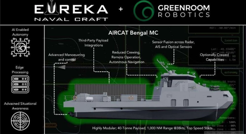
“It’s a warship with no captain”: the AIRCAT Bengal MC can launch Tomahawks on its own—and it just changed naval warfare forever
Illustration of the AIRCAT Bengal MC, an advanced autonomous naval vessel equipped with missile launch capabilities.
From AfricaTimes by Eirwen Williams
“It’s a Warship With No Captain”: The AIRCAT Bengal MC Can Launch Tomahawks on Its Own—and It Just Changed Naval Warfare Forever
In a groundbreaking development for naval warfare, the unveiling of the AIRCAT Bengal MC—a state-of-the-art autonomous vessel designed by Eureka Naval Craft in collaboration with Greenroom Robotics—promises to redefine strategic capabilities with its unmatched speed, payload capacity, and advanced missile systems.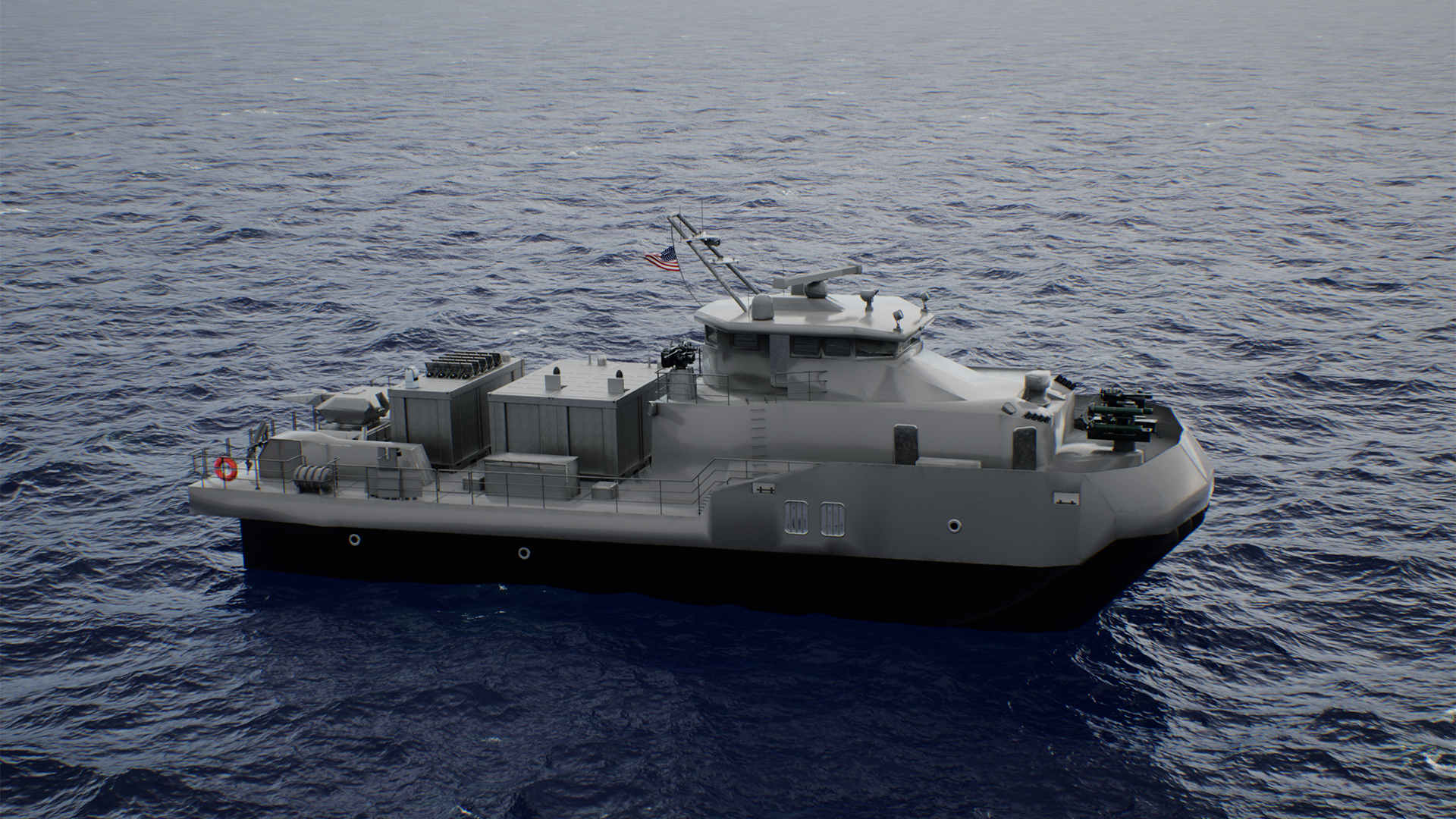 An artist’s rendition of the Bengal-MC fitted with a modular mission payload,
From AfricaTimes by Eirwen Williams
“It’s a Warship With No Captain”: The AIRCAT Bengal MC Can Launch Tomahawks on Its Own—and It Just Changed Naval Warfare Forever
In a groundbreaking development for naval warfare, the unveiling of the AIRCAT Bengal MC—a state-of-the-art autonomous vessel designed by Eureka Naval Craft in collaboration with Greenroom Robotics—promises to redefine strategic capabilities with its unmatched speed, payload capacity, and advanced missile systems.
- The AIRCAT Bengal MC is a cutting-edge autonomous naval vessel, transforming strategic capabilities in warfare.
- Equipped with Tomahawk cruise missiles and Naval Strike Missiles, it enhances military power while reducing costs.
- It features a modular design and superior fuel efficiency, offering versatility and cost-effective operations.
- Developed with Greenroom Robotics, it sets new standards in autonomous navigation and naval warfare.
The unveiling of the AIRCAT Bengal MC represents a significant leap forward in naval technology, marking a new era in autonomous warfare capabilities.
Developed by Eureka Naval Craft in collaboration with Greenroom Robotics, this vessel is hailed as the world’s most advanced autonomous naval ship.
With its sleek design and impressive capabilities, the Bengal MC is poised to revolutionize naval warfare.
This state-of-the-art vessel can be operated both autonomously and with a crew, providing unparalleled flexibility and strategic advantage.
As geopolitical tensions continue to rise, such technological advancements are becoming increasingly vital for maintaining military superiority on the global stage.
in this case a set of loitering munitions.
Eureka Naval Craft
Revolutionizing Naval Warfare with Advanced Capabilities
The AIRCAT Bengal MC is a remarkable feat of engineering, offering capabilities that set it apart from traditional naval vessels.
The AIRCAT Bengal MC is a remarkable feat of engineering, offering capabilities that set it apart from traditional naval vessels.
Its ability to carry a substantial payload of 44 tons, including two 40-foot ISO footprint modules, is matched by its impressive speed, exceeding 50 knots.
With a range of 1,000 nautical miles, the vessel can reach distant operational theaters without frequent refueling stops.
This strategic asset is equipped to launch Tomahawk cruise missiles and Naval Strike Missiles, enhancing its lethality while reducing reliance on larger, more expensive crewed warships.
This vessel is particularly attractive to major naval powers such as the US Navy, the US Marine Corps, and allied nations within AUKUS and NATO.
This vessel is particularly attractive to major naval powers such as the US Navy, the US Marine Corps, and allied nations within AUKUS and NATO.
Additionally, countries like Japan, South Korea, Vietnam, and the Philippines may find its capabilities beneficial to their own naval operations.
The Bengal MC’s autonomous operations and advanced missile compatibility make it a formidable force in modern naval warfare, offering strategic advantages that are hard to match.
Enhanced Lethality with Missile Launch Capabilities
The Bengal MC’s missile launch capabilities represent a major shift in naval strategy.
The Bengal MC’s missile launch capabilities represent a major shift in naval strategy.
Traditionally, missions requiring missile deployment necessitated the use of larger vessels, which came with significant costs and logistical challenges.
The Bengal MC disrupts this paradigm by offering a smaller, faster, and heavily armed alternative.
This innovation reduces costs while increasing operational efficiency, a critical factor in today’s budget-conscious military environments.
Bo Jardine, CEO of Eureka Naval Craft, highlights the importance of such advancements in the current naval landscape.
Bo Jardine, CEO of Eureka Naval Craft, highlights the importance of such advancements in the current naval landscape.
This vessel is not only about speed and firepower; it enhances strategic flexibility and adaptability.
The Bengal MC’s ability to carry heavier payloads at high speeds allows for rapid response to threats and opportunities, providing a tactical advantage that is increasingly necessary in complex maritime environments.
Unmatched Efficiency and Versatility
Fuel efficiency and cost-effectiveness are among the Bengal MC’s standout features, making it an appealing option for navies looking to optimize their budgets.
Fuel efficiency and cost-effectiveness are among the Bengal MC’s standout features, making it an appealing option for navies looking to optimize their budgets.
The vessel’s modular design allows it to fulfill multiple roles, from troop transport to electronic warfare and mine operations.
This versatility ensures that it can be customized to meet specific operational needs, offering a tailored solution to diverse maritime challenges.
The partnership with Greenroom Robotics enhances the vessel’s capabilities by integrating the most advanced autonomous navigation system available.
The partnership with Greenroom Robotics enhances the vessel’s capabilities by integrating the most advanced autonomous navigation system available.
This technology ensures seamless operation across all mission phases, supported by extensive trials that validate its reliability and performance.
The Greenroom Advanced Maritime Autonomy Software system represents a significant advancement in naval technology, setting new standards for autonomous operations across the globe.
Expanding the Fleet with Modular Design
The AIRCAT Bengal MC is part of a broader strategy to expand and diversify naval capabilities.
Expanding the Fleet with Modular Design
The AIRCAT Bengal MC is part of a broader strategy to expand and diversify naval capabilities.
Each vessel within the fleet is designed for specific missions, whether it be fast attack, reconnaissance, or high-speed troop transport.
The modular design philosophy allows each vessel to be customized to meet the unique demands of its mission, providing the flexibility needed in a rapidly changing naval landscape.
Eureka Naval Craft’s commitment to innovation is evident in its expanding fleet and strategic partnerships.
Eureka Naval Craft’s commitment to innovation is evident in its expanding fleet and strategic partnerships.
The collaboration with Greenroom Robotics exemplifies a forward-thinking approach to maritime autonomy.
As the naval landscape continues to evolve, the Bengal MC represents a bold step forward in military technology, offering strategic advantages that are hard to ignore.
As the AIRCAT Bengal MC sets sail, it raises important questions about the future of naval warfare. How will such autonomous technology reshape global naval strategies, and what challenges and opportunities will arise as a result?
As the AIRCAT Bengal MC sets sail, it raises important questions about the future of naval warfare. How will such autonomous technology reshape global naval strategies, and what challenges and opportunities will arise as a result?
The answers will undoubtedly influence the next generation of military innovation and strategic planning.
Links :
- TWZ : Bengal-MC Air Cushion Catamaran Aims To Be The Navy’s Future Ultra-Adaptable Combat Ship
- News release from Eureka Naval Craft, US naval defense company and Australian maritime autonomy company, Greenroom Robotics
- New Atlas : Autonomous, armed, and fast: Meet the Bengal MC warship
- Energy Reporters : “44 Tons at 57 Miles Per Hour”: US Unveils First Autonomous Warship Carrying Tomahawk Missiles Without Any Crew
Monday, October 13, 2025
French sailor won round-the-world solo race while treating himself for cancer
Credit: AFP via Getty Images/Loic Venance
From The Telegraph by Tom Cary
Charlie Dalin set record time of 64 days, 19 hours, 22 minutes and 49 seconds, all the while receiving immunotherap
The Vendée Globe round-the-world yacht race is known as the “Everest of the Seas” for good reason. Requiring competitors to sail alone for months on end, in isolated seas, performing all boat repairs unassisted, enduring extreme sleep deprivation, it is about as tough a physical and mental challenge as it is possible to imagine.
But the winner of the last edition, Frenchman Charlie Dalin, has now revealed that, at the same time as he was battling the elements, he was also undergoing treatment for cancer.
Dalin, 41, completed the toughest single-handed yacht race in the world in January this year in a record time of 64 days, 19 hours, 22 minutes and 49 seconds despite a diagnosis that came roughly a year before the start.
Dalin was diagnosed with a gastrointestinal stromal tumour in late 2023.
“I had a tumour 15 centimetres long on my intestine,” Dalin told L’Equipe in an interview ahead of Thursday’s publication of his book La Force du Destin (The Force of Destiny) in which he recounts his illness and treatment.
“They removed it in February [2024], but it came back elsewhere in April.”
Dalin, who races for MerConcept, the Concarneau-based team founded by François Gabart, said he underwent immunotherapy throughout the race.
“I was lucky to tolerate the treatment very well during the Vendée Globe,” he said. “Continuing to do what I love helped me focus on something other than the disease.”
Dalin said he first felt symptoms in late 2023 during a training sail.
⛵️ CHARLIE DALIN REMPORTE LE VENDÉE GLOBE
— la chaine L'Équipe (@lachainelequipe) January 14, 2025
Le skipper pulvérise le record avec un tour du monde bouclé en 64 jours, 19 heures, 22 minutes et 52 secondes. Une performance exceptionnelle ! 🏆 pic.twitter.com/SpXfkMr88h
Dalin, who races for MerConcept, the Concarneau-based team founded by François Gabart, said he underwent immunotherapy throughout the race.
“I was lucky to tolerate the treatment very well during the Vendée Globe,” he said. “Continuing to do what I love helped me focus on something other than the disease.”
Dalin said he first felt symptoms in late 2023 during a training sail.
He underwent emergency scans and began treatment immediately, determined not to delay.
“There’s no logic to it. I don’t drink, I don’t smoke, I’m fit. Why me? No reason – just bad luck,” he said. “At first you see it as an injustice. Then you accept it.”
“There’s no logic to it. I don’t drink, I don’t smoke, I’m fit. Why me? No reason – just bad luck,” he said. “At first you see it as an injustice. Then you accept it.”
Dalin learnt of his cancer diagnosis roughly a year before the start of the non-stop Vendee Globe race Credit: Getty Images/Sebastien Salom-Gomis
In a separate interview with AFP, he added: “I stuck to my strategy, sleeping an average of 6½ hours per 24 hours, which is more than on my first Vendée. I had stomach pains, but I just told myself: you don’t have time to worry about that. The pains went away as quickly as they had come. By the time I got back to shore, I had almost forgotten about them.”
Dalin’s win in January was particularly well received because the Frenchman famously finished second in his first attempt at the Vendée four years earlier, despite having crossed the line first.
Dalin took line honours in Les Sables d’Olonne in January 2021, only for his compatriot, Yannick Bestaven, to be awarded the win despite crossing the line in third place.
Bestaven was awarded a time compensation of 10 hours and 15 minutes for his role in the dramatic rescue of fellow competitor Kevin Escoffier.
Such rescues are part and parcel of the Vendée Globe, a race in which competitors are sometimes so isolated their nearest human neighbours are on the International Space Station.
Such rescues are part and parcel of the Vendée Globe, a race in which competitors are sometimes so isolated their nearest human neighbours are on the International Space Station.
If you get into trouble, and you cannot rescue yourself, invariably it is your fellow competitors who need to come to your aid.
Jean Le Cam, the skipper who eventually rescued Escoffier after his boat “folded in two” on day 23 in 2020, was himself saved by Vincent Riou in 2009.
Jean Le Cam, the skipper who eventually rescued Escoffier after his boat “folded in two” on day 23 in 2020, was himself saved by Vincent Riou in 2009.
Briton Pete Goss famously rescued Raphaël Dinelli in the 1996 Vendée Globe.
Alex Thomson was rescued by Mike Golding in the Velux 5 Oceans race in 2006.
Briton Pip Hare lost her mast in the Southern Ocean in the last Vendée Globe, but was able to fashion a makeshift rig before “limping” 800 nautical miles to Melbourne.
Briton Pip Hare lost her mast in the Southern Ocean in the last Vendée Globe, but was able to fashion a makeshift rig before “limping” 800 nautical miles to Melbourne.
She penned an emotional column for Telegraph Sport about the experience.
Of 240 race starts in the history of the Vendée Globe, only 146 have resulted in a classified finish.
Dalin remains under medical treatment, but hopes to rebuild strength after losing about 10 kilograms. “It’s stabilised now, thankfully. I just need to regain some muscle,” he said.
The sailor said Macif, his sponsor, has confirmed its continued support, with future plans due to be announced on October 13.
He may attend the start of the Transat Jacques-Vabre later this month, but is focused for now on recovery.
“To be at the start of the Vendée Globe, that was incredible. A year earlier I was in hospital, unsure if I would live,” he said. “Winning it – after all that – felt like I’d already won once before.”
He also told Voiles et Voiliers: “Frankly, if a screenwriter had imagined a script around the Vendée, he would never have dared to write the story of a sailor with cancer, who returns to the race of his dreams and wins it after crossing the line first.”
Links :
- NYTimes : Charlie Dalin won Vendee Globe in record time while undergoing cancer treatment
- VendeeGlobe : Discovering Dalin
Sunday, October 12, 2025

Subscribe to:
Posts (Atom)