Flysufer kiteboarding rider Fly Fisch his new edit is truly a special
one, making us jealous, out alone on the Mediterranean sea, in pure
silence, foiling his way around beautiful Talamone Bay in Italy.
Saturday, June 9, 2018
Adrift
From Weather4D by Francis Fustier
Adrift, a drama adventure movie about sailing the high seas is in theaters since June first.
The story begins on September 23, 1983. Tami Oldham (Shailene Woodley) and Richard Sharp (Sam Claflin) leave Tahiti.
They believe this will be a side trip on their cruise around the South Pacific and New Zealand.
A British couple hired them in Papeete to deliver their 44-foot yacht, Hazana, to San Diego while the couple flies home on a family emergency.
However, Tami and Richard couldn’t anticipate they would be sailing directly into Raymond, one of the most catastrophic hurricanes in recorded history.
In Adrift, Tami awakens in aftermath of the storm to find Richard badly injured and their boat in ruins.
With no hope of rescue, Tami must find the strength and determination to save herself and the only man she has ever loved.
Based on a true story
Real life wasn’t as forgiving as the movie. Richard Sharp lost his life, Tami Oldham spent 41 days in survival mode alone on the ocean while suffering severe head injuries.
It took her years to cope with the trauma caused by the loss of her fiancé and the violence of the hurricane.
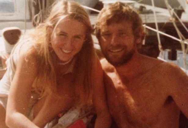
Tami Oldham Ashcraft and Richard Sharp
Oldham eventually wrote the story of her ordeal in a book titled “Red Sky In Mourning: The True Story Of A Woman’s Courage And Survival At Sea” from which Adrift is inspired.
Why did this happen in the first place?
Back in the 1980s, weather forecasting and telecommunications weren’t as advanced as they are today by any means.
Sailors used to listen to radio broadcasts on shortwave receivers, a boat makes noise at sea, and there wasn’t a replay button in case part of the weather forecast wasn’t fully heard or understood.
In 1978, the first hurricane-tracking model based on atmospheric dynamics – the movable fine-mesh (MFM) model – began operating.
It was actually not until well in the 1980s that numerical weather prediction gained credibility.
It consistently outperformed statistical models only in the 1990s.
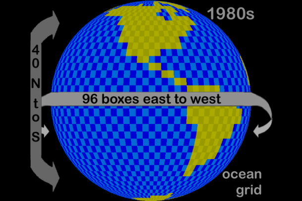
Ocean grid in the 1980s
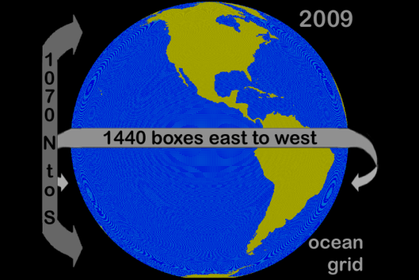
Ocean grid in 2009
Later in the mid-1980s, it became an operational model.
The National Weather Service started using this model in 1995 and kept improving it.
This is more than 10 years after Tami and Richard relied on statistical models received from the weather channel WWV aboard Hazana.
While there were some hints, it wasn’t obvious to decipher what was in the making even four days before they got hit by the hurricane.
It seems there was a lot of unknown : “Richard later scribbled ‘Cyclonic’? in the logbook” — Tami describes Richard as not appearing overly concerned and they continue their route North East to San Diego.
They started paying close attention to the depression on October 9th.
It was then 1300 NM away, moving West at 12 knots towards them, almost twice their boat’s max speed.
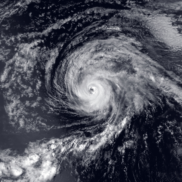
Hurricane Raymond 1983
Within 48 hours, Raymond’s trajectory changed and it was heading further to the Northwest.
Tami and Richard simply could not escape it at that point.
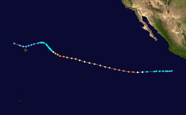
Hurricane Raymond track 1983
Unfortunately the book doesn’t explain the rationale to make the decision to head North instead of South to get closer to the safer Equatorial zone.
Would have they been short on food, water and fuel in that case?
What has changed since 1983?
Three fundamental things have dramatically improved safety at sea
Weather models have become way more sophisticated and hence forecasts are more accurate.
GRIB files and satellites make weather models accessible anywhere at anytime
One no longer needs to decipher an audio message coming from a shortwave radio.
Rich animated graphic representations of wind, waves and currents have made weather forecasts incredibly precise and intuitive.
Furthermore, the data can be crunched to produce simulations and suggest optimal routes.
What remains the same?
The need to analyze forecast data to anticipate the worst possible conditions.
Departure date and time must depend on weather conditions to be on the safe side.
The need to do it at least once a day and to adjust the route if necessary.
While routing calculation estimates x numbers of days at sea, add 15-20% to that value and make it your benchmark for food, water and fuel supplies.
Avoid sailing in tropical regions during hurricane season.
My last major sailing trip was to deliver a 42 footer catamaran from Cuba to France.
I got the offer on a Saturday and landed in Havana just three days later.
It was late June and hurricane season was around the corner.
It was consequently much safer to go as early as possible with a crew of two rather than spending time recruiting a crew of four which would have delayed our departure and potentially exposed us to extreme weather.
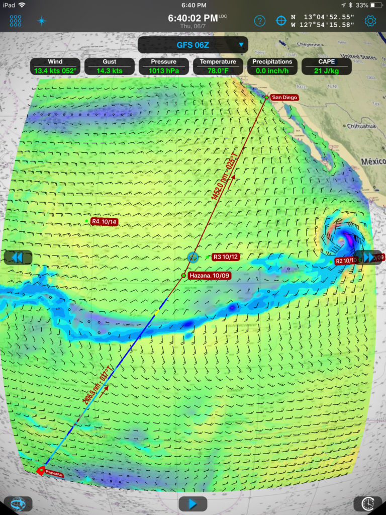
Hazana versus Raymond locations in 1983 layered with 06/07/2018 GFS model
Sources:
- https://www.imdb.com/title/tt6306064/
- https://en.wikipedia.org/wiki/1983_Pacific_hurricane_season#Hurricane_Raymond
- http://articles.chicagotribune.com/2003-03-19/features/0303180492_1_sailing-cabin-south-pacific
- https://www.gfdl.noaa.gov/climate-modeling
- Outside : The Real Survival Story Behind 'Adrift'
- Allthatinteresting : The True Story Of “Adrift” And Tami Oldham Ashcraft’s Survival At Sea
- HistoryHollywood : Adrift
Friday, June 8, 2018
World Oceans Day focuses on stopping plastic pollution

June 8th
From Eco Watch by Pete Stauffer
Ever since the United Nations declared June 8th to be World Oceans Day in 2002, people and groups from around the world have used the occasion to celebrate the ocean and take steps to protect it.
Now, with the ocean facing more threats than ever, it's time for all of us to come together to protect our treasured marine environment.

Unsplash
Our federal leaders are waging an unprecedented assault on the ocean.
The Trump administration has proposed new offshore drilling in more than 90 percent of U.S. waters, while targeting marine protections for potential repeal.
Meanwhile, plastic pollution continues to proliferate in our ocean, choking and entangling marine wildlife, as government leaders and corporate interests refuse to take meaningful steps to address the problem.
This is why grassroots action is desperately needed to protect the health of our ocean.
As Mahatma Gandhi famously said, "If the people lead, the leaders will follow."
So, on June 8th, let us all be reminded of our responsibility as ocean advocates to protect this incredible resource for now and the future.
Celebrate World Ocean Day with NOAA's National Ocean Service.
What do you know about our ocean?
Here are three ways to take action on #WorldOceansDay 2018.

1. Tell Your Federal Leaders to Stop the Rollback of Ocean Protections
The administration and members of congress need to hear from people who value the ocean and oppose proposals that would damage the marine environment.
Please visit Surfrider's Stop Offshore Drilling campaign page to learn how you can take action to defend our coastlines from new oil rigs.
Please also complete this action alert to urge your representatives to support our Marine Sanctuaries and National Monuments.
Or better yet, pick up the phone and call your representatives in the Senate and House!
For more information on Surfrider's Ocean Protection initiative click here.
2. Reduce Your Consumption of Plastics With a #ZeroPlasticLunch!
Plastic pollution represents one of the greatest threats to the health of our ocean.
Every year, millions of tons of plastic enters marine waters, wreaking havoc on wildlife and ecosystems.
That's why the theme of this year's World Oceans Day is preventing plastic pollution and encouraging solutions for a healthy ocean.
Surfrider is partnering with CNN to ask students around the world to celebrate #WorldOceansDay with a #ZeroPlasticLunch.
Join by sharing photos of your lunch on social media using the hashtag #ZeroPlasticLunch and tagging @surfrider with changes you made to your meal and why.
For more tips on reducing your consumption of plastics, please visit Surfrider's Rise Above Plastics page.
3. Join the March for the Ocean (or Wear Blue to Show Support)
On Saturday, June 9th, ocean advocates are assembling in Washington DC and sister events around the country to March for the Ocean.
The goal is to show grassroots support for stopping offshore drilling, reducing plastic pollution, and preserving coastlines in the face of rising seas.
Surfrider Foundation will have a strong presence at the march, with chapter members and staff traveling to our nation's capital for the event.
Those who can't make it to Washington DC are encouraged to 'Wear Blue for the Ocean' to show their support in local communities and on social media.
For more information go to: www.marchforocean.com and engage with #MarchForOcean on your favorite social channels.
Links :
- Surfrider Foundation: Home
- How a Small Piece of Plastic Wrap Likely Killed a Harp Seal
- Parley Continues Its Innovative Campaign to Save Our Oceans With ...
- A Fishing Town in India Is Building a Road to a Plastic-Free Ocean
- Future of plastic
Thursday, June 7, 2018
High seas fishing isn’t just destructive—it’s unprofitable

Government funds prop up more than half of fishing in the open ocean, a new study reveal
A fish’s journey from ocean to plate may not be as straightforward as it sounds.
Most people are aware that a fisher, a grocer and a cook were involved in that journey.
But a new study finds that governments lend a hand, too—and a mighty big one.
A paper, published Wednesday in the journal Science Advances, found that as much as 54 percent of high seas fishing would be unprofitable were it not for governments covering some of the industry's costs.
To a lesser degree, the study also found that exploited labor and underreported catch may explain how large vessels afford to fish in international waters.
“The study confirmed that much of the high seas fishing does not make sense,” says study author and National Geographic Explorer-in-Residence Enric Sala.
“If it's ecologically destructive and economically unprofitable, why don't we end all high seas fishing?”

A fisherman checks his fishing lines while fishing on the high seas.
The
high seas is defined as the open waters outside a country's exclusive
economic zone, generally 200 miles past the shore.
Photograph by Chris Johns, National Geographic Creative
In 2016, just over 3,600 vessels actively fished on the high seas—the open ocean outside any country's jurisdiction.
To better understand this impact, the research team of ecologists, data scientists, and economists looked at the most recent cost datasets available, from 2014.
They found that the total cost of fishing in that year ranged anywhere from 6.2 to 8 billion USD and that subsidies totaled around 4.2 billion USD.

This boat is fishing for tuna, a species commonly fished out of the high seas.
Photograph by Paul Nicklen, National Geographic Creative
By far, their data showed that China and Taiwan net the fewest profits in the sector, while exerting some of the most effort.
Russia was also shown to have an unprofitable fishing industry, even with subsidies.
However, subsidies weren't just given to unprofitable fishing vessels.
The study also found that marginally profitable companies in Japan, South Korea, Spain, and the U.S.
had their profits boosted by government subsidies.
“There are three different categories [of subsidies],” says University of British Columbia economist Rashid Sumaila, one of the study's authors.
He and his colleagues began compiling data on fishing subsidies in 2000, and they found that not all subsidies were harmful.
Some were ambiguous and hard to categorize.
Others were beneficial and went toward activities like sustainable management, research, and regulation enforcement.
Other subsidies helped companies increase their carrying capacity—essentially these allowed boats to fish more in fisheries that might be at risk of depletion.
Rather than directly providing a fishing company with a check, governments may offer tax breaks, help pay for fuel costs, provide money to upgrade gear, or fund infrastructure like ports.
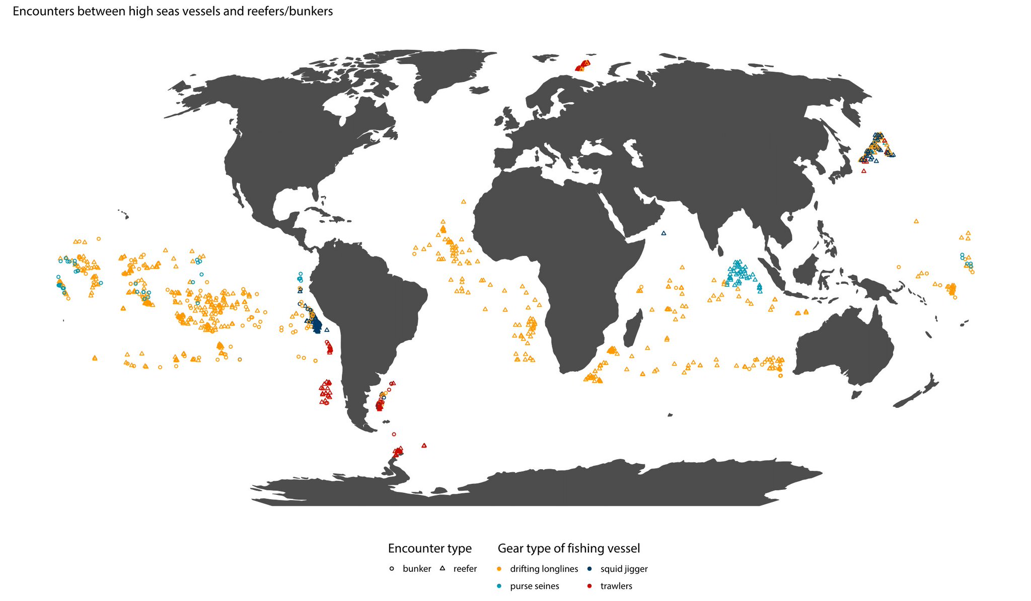
Encounters between high seas vessels and reefers/bunkers
Spying from space
Open ocean outside EEZs, generally 200 miles beyond the shore, is free game.
The UN's Food and Agriculture Organization outlines a code of conduct on these high seas, but regulation is minimal and enforcement is scant.
What's more, vessels often have a competitive interest in not sharing details about their activities.
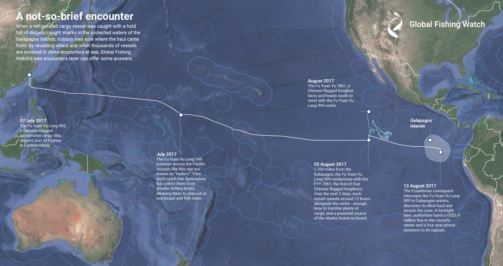
Global Fishing Watch's new encounters layer reveals for the first time where and when thousands of vessels are involved in close encounters at sea.
To detect pairs of vessels meeting at sea, analysts applied machine learning algorithms to more than 30 billion Automatic Identification System (AIS) messages from ocean-going boats to find tell-tale transshipment behaviour, such as two vessels alongside each other long enough to transfer catch, crew, or supplies.
To detect pairs of vessels meeting at sea, analysts applied machine learning algorithms to more than 30 billion Automatic Identification System (AIS) messages from ocean-going boats to find tell-tale transshipment behaviour, such as two vessels alongside each other long enough to transfer catch, crew, or supplies.
To compile data for one of the world's most inaccessible regions, marine data scientist and study author Juan Mayorga turned to a program called Global Fishing Watch that tracks vessels from space using the satellite-transmitted signal from AIS—Automatic Identification System—that vessels are required to transmit.
Earlier this year, he used the data to find that industrial fishing covers a third of the planet.
“When we first came up with this idea, we did not have a good handle on what fishing on the high seas looked like,” says Mayorga.
Over a two-year period, he determined how many vessels were operating in the high seas and how often, though he adds that the study's data can't account for all high seas fishing activity.
Some vessels forego AIS or turn it off to intentionally be covert.
With the data for the ships they could measure, Mayorga used models to estimate fuel costs based on a vessel's size, location, distance traveled, and speed.
He could also see the type of vessel and what it was fishing for, which helped him estimate needed labor.
Looking at existing information on minimum wage laws and typical cost of labor, Mayorga was able to estimate labor costs on a scale.
He notes, however, that this estimate is the least certain part of the study, because reports from several non-governmental organizations show the fishing industry has a history of exploitative labor practices, verging on or directly resulting in slave labor in some regions.
“Labor is what drives the uncertainty in our analyses,” he says.
With his range of operating costs, Mayorga then estimated the haul each vessel was bringing to market.
The study's authors suspect that catch may be underreported in some cases.

Bottom trawling is one of the most destructive fishing practices.
It
commonly drags coral from the ocean floor, like this large piece of
Paragorgia coral dredged from waters near New Zealand.
Impacts
All-in-all, industrial fishing on the high seas is a relatively small portion of global fishing—accounting for only six percent of all fishing activity.
Fishing subsidies in EEZs have been controversial, with the World Trade Organization considering banning them in the past decade.
So why subsidize fishing for more expensive fleets that yield smaller returns, the study's authors ask.
According to a representative from the UN's Food and Agriculture Organization, food security is often cited as a major reason for providing subsidies to fishing industries.
But a statement published by the agency in 2016 acknowledges a need to regulate subsidies to ensure sustainability.
“Fisheries subsidies warrant concern,” says FAO representative Christopher Emsden, adding, “Care is needed as they can serve development purposes in some cases, (although these would likely be for small-scale fishers and not those featuring in the study).”

The study identified squid fishing as an unsustainable but government-funded fishing practice.This fisherman holds a squid in the green light they use to bait them.
Photograph by Ben Horton, National Geographic Creative
Photograph by Ben Horton, National Geographic Creative
In addition to depleting fisheries, high seas fishing subsidies also threaten important natural habitats, says Sala.
Deep-sea bottom trawling, one of more common high-seas fishing practices, is problematic, he notes.
“Trawling is one of the most destructive practices on the planet,” says Sala.
“They have nets so large they can hold a dozen 747 jets.
These huge nets destroy everything in their path, including deep-sea corals.
And it would not be profitable without subsidies.”
In addition, all three researchers noted that high-seas fishing may perpetuate exploitation.
“[Unprofitability] has implications about the extent to which unfair labor practices drive fishing on the high seas,” notes Mayorga.
What if we could save the fishing industry and protect the ocean at the
same time?
Marine ecologist Enric Sala shares his bold plan to safeguard
the high seas -- some of the last wild places on earth, which fall
outside the jurisdiction of any single country -- by creating a giant
marine reserve that covers two-thirds of the world's ocean.
By
protecting the high seas, Sala believes we will restore the ecological,
economic and social benefits of the ocean.
"When we can align economic
needs with conservation, miracles can happen," Sala says.
The future of high-seas fishing
Transparency, whether because industry officials intentionally withheld information or governments lacked records, presented a major hurdle for how researchers comprehensively assessed the high-seas fishing industry.
To combat what they say is an economically and environmentally unsound practice, the research team says increasing transparency is key.
More stringently enforcing AIS, for example, is one way Sala says regulators could monitor the full impact of high-seas fishing.
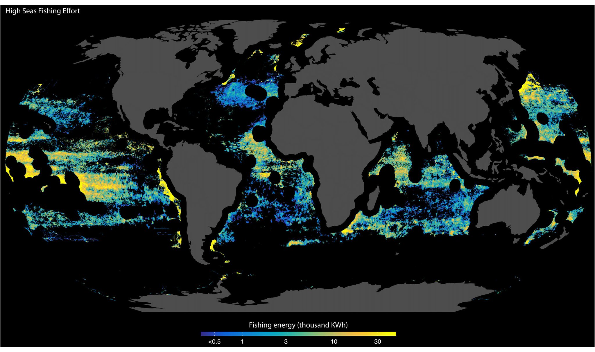
High seas fishing effort (energy in kWh)
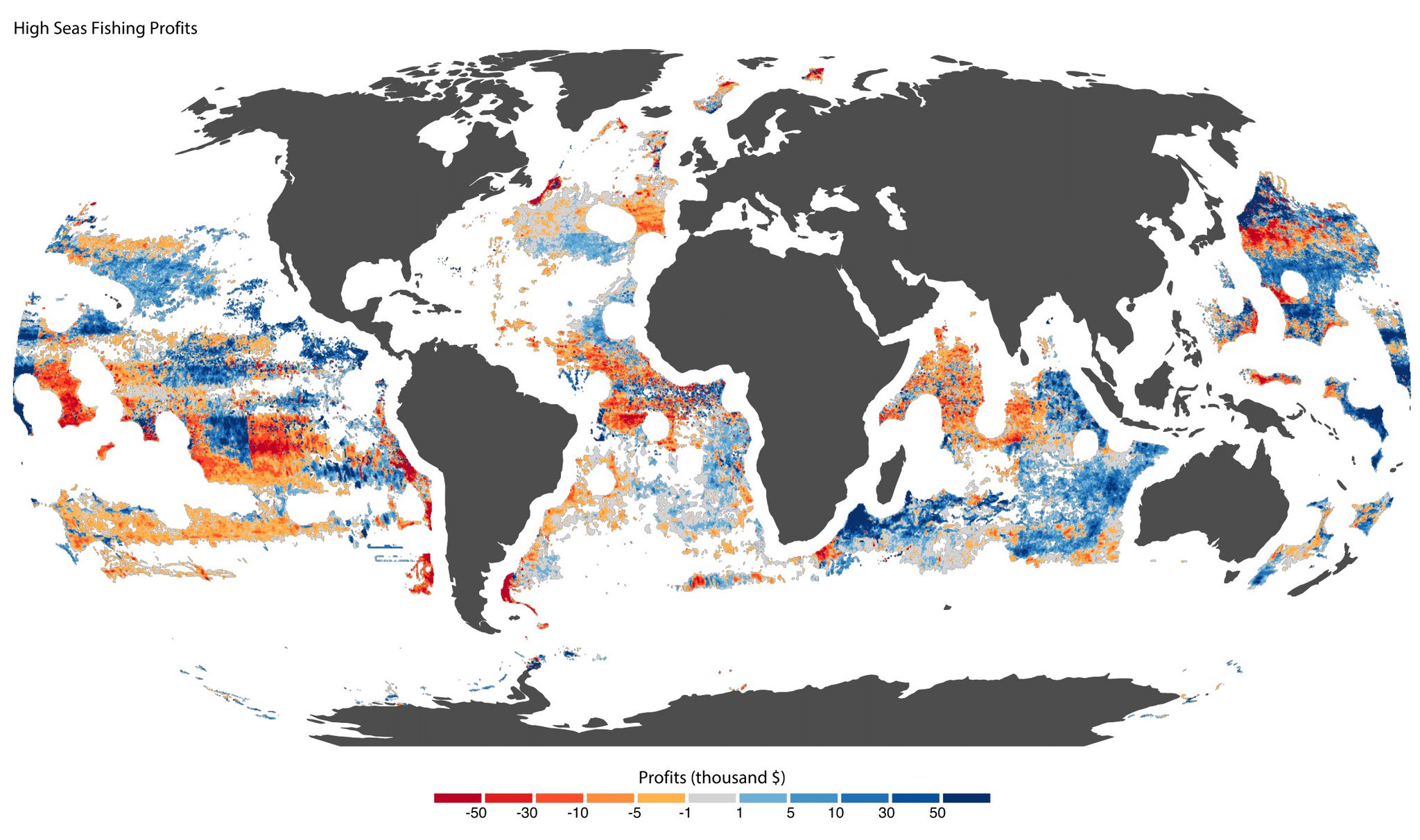
High seas fishing profits in thousands US$
courtesy of Global Fishing Watch
courtesy of Global Fishing Watch
Sumaila would like to see the World Trade Organization ban or roll back fishing subsidies, but despite extensive discussion at the organization progress has been minimal.
The last vote was shot down in December of last year, primarily due to procedural hurdles.
The WTO will consider changes to fishing subsidies again in 2019.
The high seas have sometimes been seen as an avenue for countries to compensate for other overfished waters.
China, for instance, has experienced extensive overfishing in its own waters, and a study published in April 2017 found the country trying to compensate by fishing in waters as far as western Africa.
Depleting fisheries is a growing problem.
Of the 600 fisheries monitored by the FAO, more than half are depleted to the point of yielding little to no catch.
Last December, the U.N. also began talks to create a framework to protect high-seas biodiversity.
Negotiations are expected to be ongoing for the next two years.
The high seas doesn't belong to any one country, which means regional governments often clash during negotiations.
In the past, some have objected to long-term changes, hoping to leave the door open to commercial opportunity, while others are worried they may be impacted by declining biodiversity.
Links :
- Sciences Advances : The economics of fishing the high seas
- Phys : Study on economics of fishing on the high seas
- Earth : High seas fishing is unprofitable without government subsidies
- Nature : How to save the high seas
- Pew : What Do You Know About Illegal Fishing?
- Pacific Standard : This Satellite-Based Monitoring System Could Be a Game-Changer for ...
- BBC : How to spot the secretive activities of rogue fishing boats
- Reuters Graphics : Casting a wider net, how fishing fleets comb the ocean
- GeoGarage blog : New maps show the utterly massive imprint of fishing on the world's ... / The way the world catches fish defies all economic ... / How illegal fishing is being tracked from space / Nine of world's biggest fishing firms sign up to ... / Fighting illegal fishing with Big Data / Big brother at sea / An ingenious use of big data helped expose a ... / Global Fishing Watch lets you track 35000 fishing ... / Google's global fishing watch is using 'manipulated ... / How satellite technology is helping to fight illegal fishing / The plan to map illegal fishing from Space
Wednesday, June 6, 2018
US Coast Guard chart old nautical charts
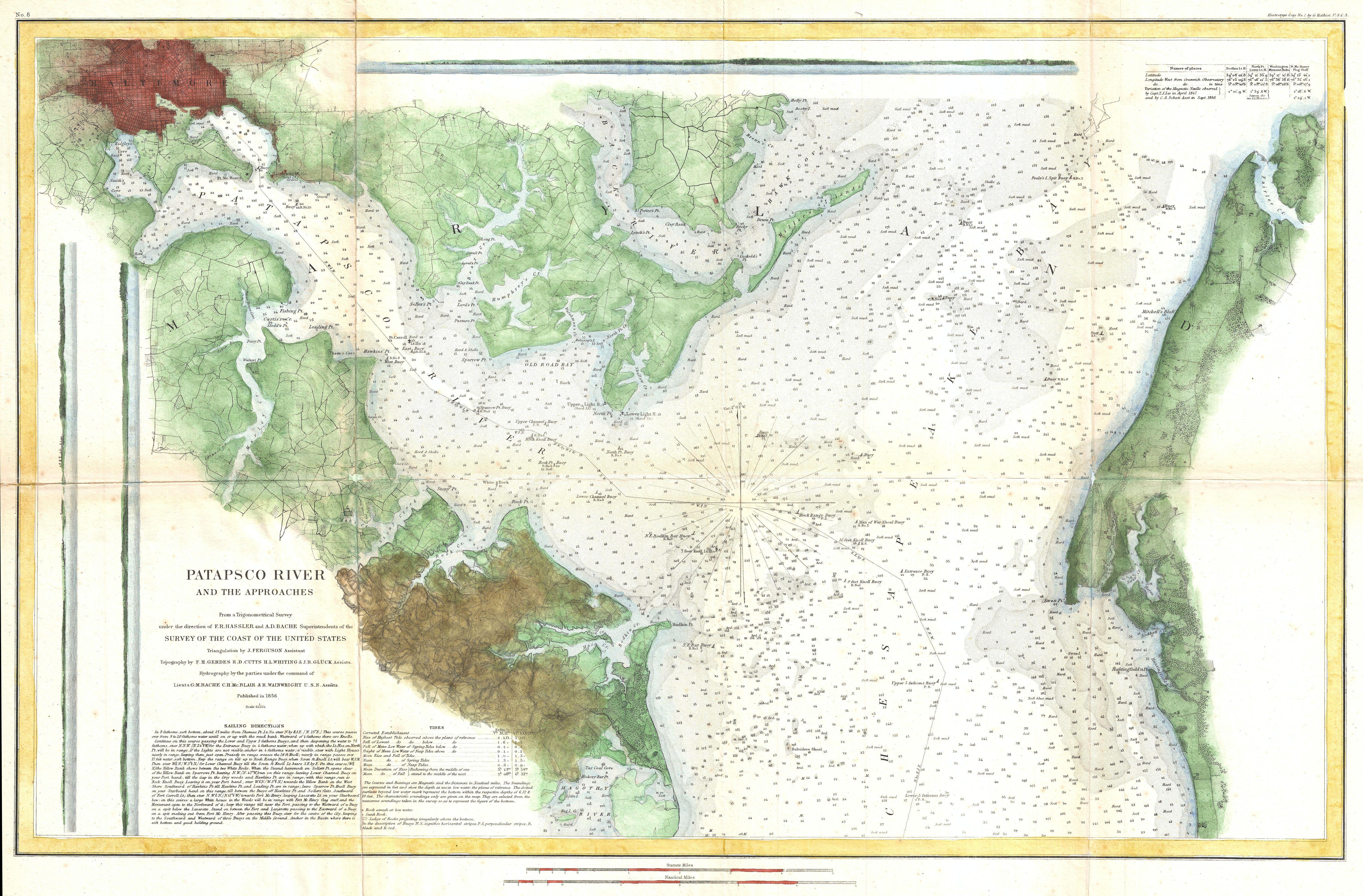
Patapsco River, Chesapeake Bay, Baltimore 1856

Patapsco River, Chesapeake Bay, Baltimore with the GeoGarage platform (2018 NOAA chart)
 Plymouth, MA (1857, scale 1:20,000)

Plymouth, MA with the GeoGarage platform (2018 NOAA chart)

Plymouth, MA with the GeoGarage platform (2018 NOAA chart)
_-_Geographicus_-_SanAntonioCreek-uscs-1857.jpg)

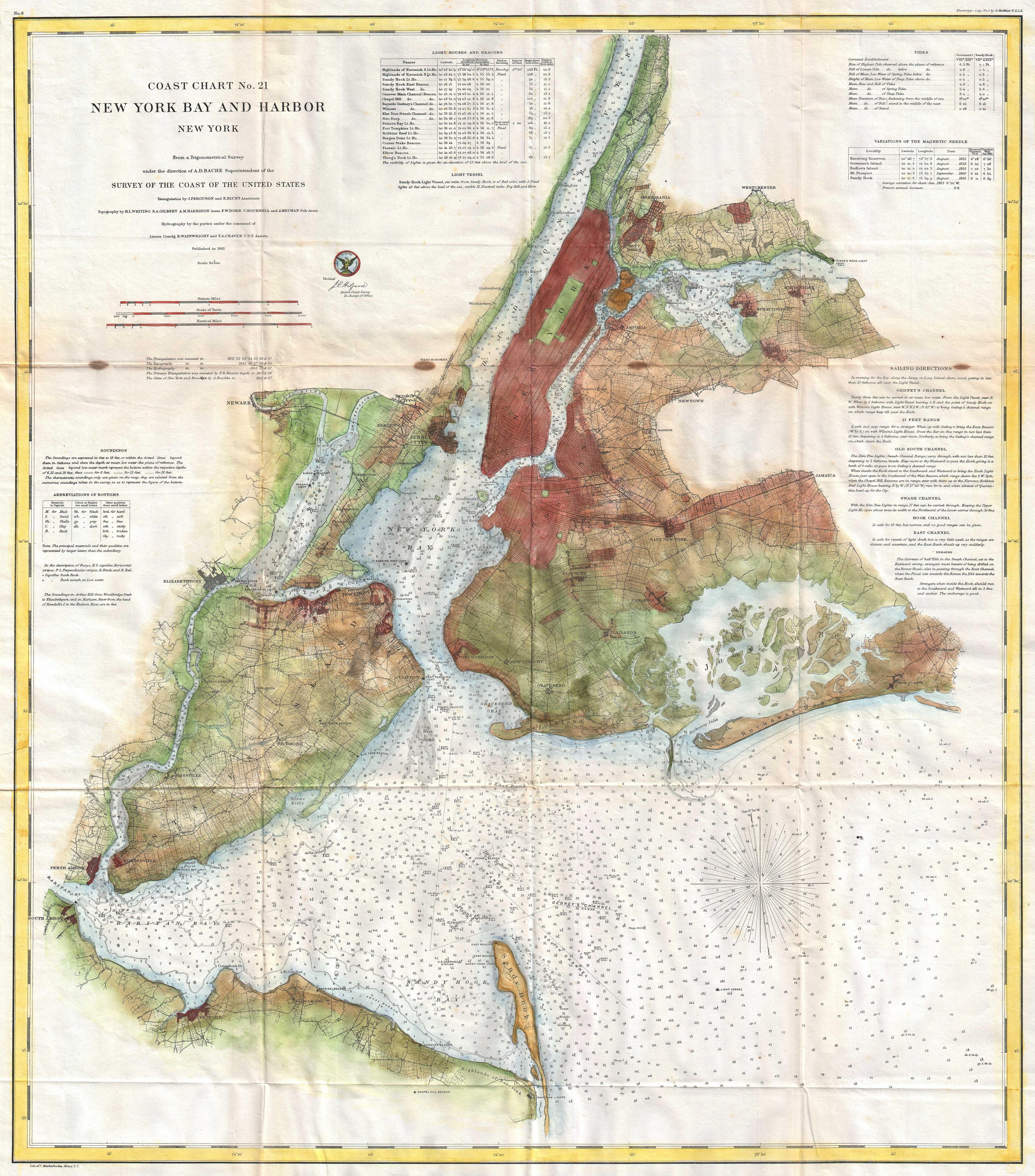
New York Bay and Harbor 1861

New York Bay and Harbor with the GeoGarage platform (2018 NOAA chart)
Links :
- NOAA : Charting History

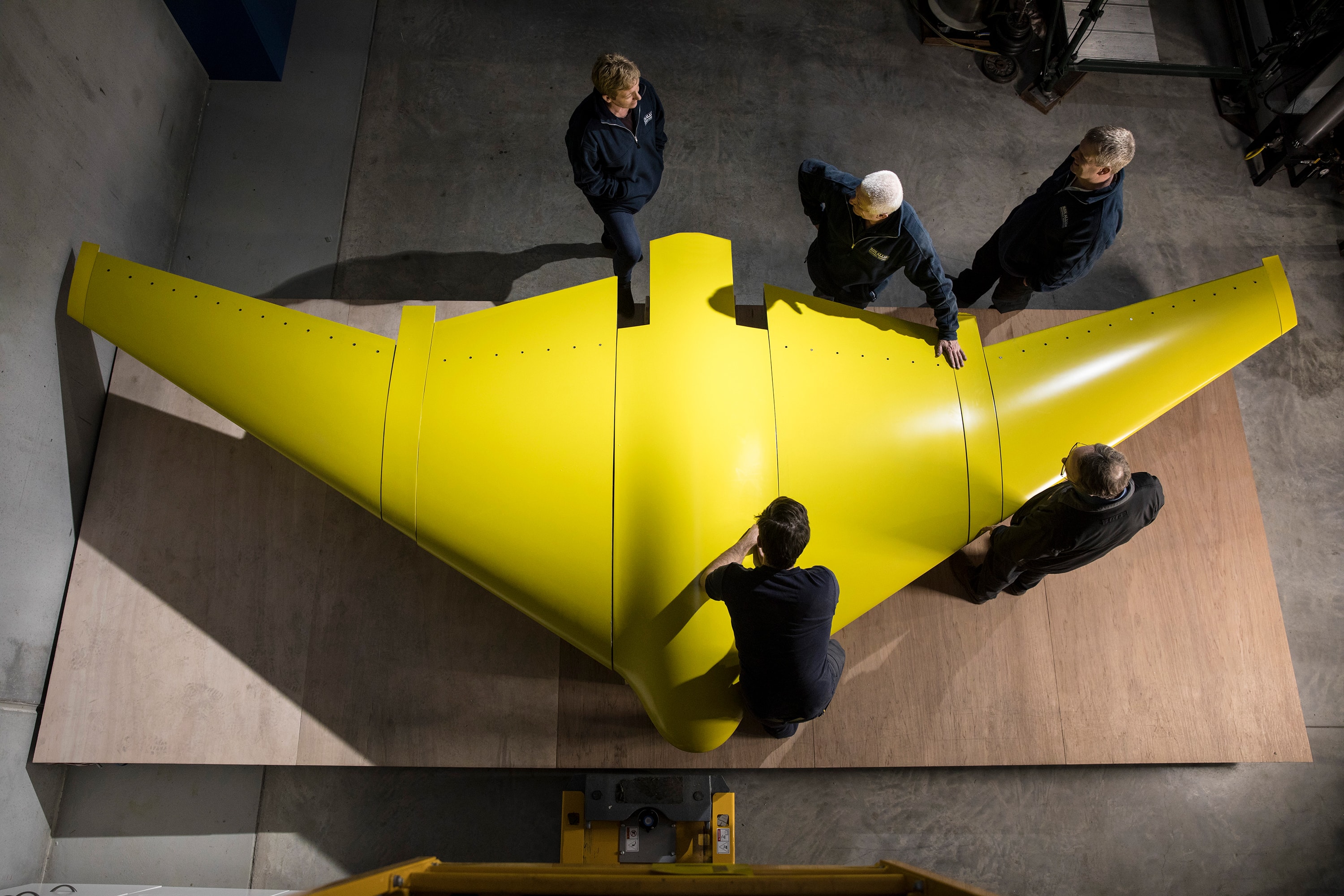
Defence underwater glider may be future of ocean military surveillance
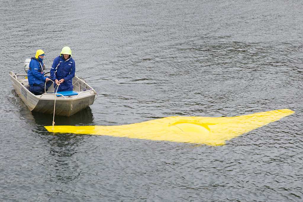
The Sun Ray glider being tested in Woronora Dam in Sydney.
Photo: Defence Media Australia
These are the first images of the experimental Sun Ray military undersea surveillance glider, a $3.17 million defence project which looks as though it has come straight out of a James Bond movie.
Shaped like a stingray, the prototype was built in a western Sydney suburb and has just undergone trials in Woronora Dam.
It could be the forerunner of technology to be used one day in anti-submarine warfare or to monitor vessels illegally entering Australian waters.
The link to the movie industry is actually quite real.
The designer of the Sun Ray is Ron Allum who also built the Deepsea Challenger underwater vehicle for US film director James Cameron.
The director then piloted it to the bottom of the Mariana Trench, the deepest place in the ocean, in 2012.
Allum was also a member of Cameron’s historic Titanic expedition team in 2001.
Underwater inventor Ron Allum with the Sun Ray glider.
The glider contains an internal buoyancy vessel that can be flooded or pumped out to change the vehicle's displacement, making it sink or rise.
The resulting movement of water over the wing's surface generates forward thrust, removing the need for propeller or water-jet propulsion.
It is built partly of the same lightweight composite foam as the Deepsea Challenger and holds its shape even at extreme pressures, giving the glider greater depth capability than manned submarines.
It may allow missions of up to three months, gliding more than 2000 nautical miles.
The Defence Science and Technology group says to meet future requirements for "military undersea surveillance", a new breed of autonomous equipment is required.
"High performance 'cross country' underwater gliders show great promise as mobile acoustic surveillance platforms," it states.
Mr Allum said the oil and gas industry had also shown interest in the high tech structural foam but it was defence that had shown most enthusiasm.
"Defence came to us and said could we build something that could go deeper and faster and we said yes. The Sun Ray can also carry a payload that is of interest to scientists and we are now looking at getting other contracts," he said.
"Gliders are very quiet and that is certainly the advantage of this vehicle. It does use the motors for a few minutes when it could be detected but then the noise stops and it can be deadly quiet."
Likely uses for the glider which is funded by the Defence Innovation Hub, could include the monitoring of marine life, mapping the sea bed and taking temperature measurements for climate change research.
But it could also come into its own in the event of the loss of an aircraft, Mr Allum said.
"The glider may not be the ideal vehicle to find MH370 but if you had a fleet of these gliders in the ocean, then if something like that happened you would be able to pinpoint that plane straight away. It would be like having satellites in the sky," Mr Allum said.
David Liebing, Research Leader at the Defence and Science Technology group was slightly more circumspect about the way gliders could be utilised in the future.
"It's about putting sensors on it that will give us information about what's happening under the ocean," he said.
"What we are trying to do is, basically, take measurements under the ocean of everything from the temperature, the oceanography to measuring the ambient noise in the ocean and to knowing, for example, what marine life is around.
"We are exploring concepts, we are trying to make them fly underwater correctly. What we are concentrating on is the technology.
"It's a sensor that is out there, that can have long endurance, that we can measure the physical properties of what's happening under the water. It's no different to any other manned platform we have out there with sonar on it."
Asked if the glider could be used to detect submarines, he said: "This project is not specifically about that and that is a long bow to draw at this time.
It can listen under the water.
At this stage we are looking at sensing the undersea environment and seeing what defence can make of that.
"People dream about unmanned combat aircraft, we are nowhere near that sort of stage in the undersea environment. A manned submarine comes with intelligence, this doesn't come with intelligence yet. That's a huge step."
Links :
Tuesday, June 5, 2018
A maritime revolution is coming, and no one’s in the wheelhouse
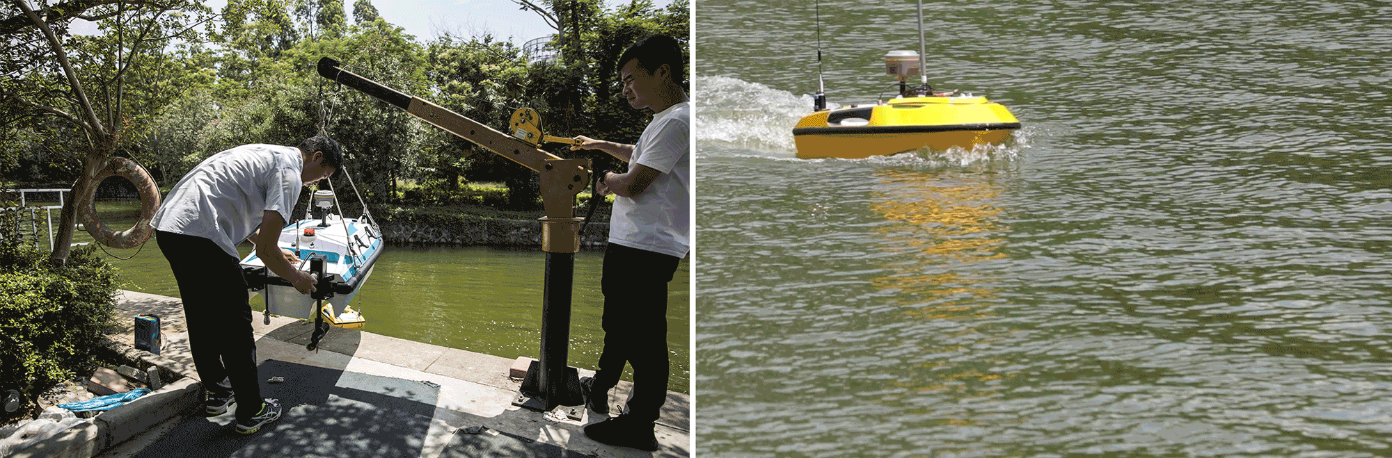
USV for water quality monitoring, bathymetric survey...
From Bloomberg by Blake Schmidt
Oceanalpha wants to build the world’s first autonomous cargo ship.
In the vast, freezing Ross Sea, China’s “Snow Dragon” icebreaker needed to find a safe anchorage before it could begin its mission to set up China’s fifth Antarctic research station.
The solution was to deploy one of Zhang Yunfei’s freezer-tested boat drones to map the ocean floor.
For Zhang, it was the latest in a string of government contracts — from surveying Tibetan lakes to testing river pollution — that have helped him turn a university project into China’s largest unmanned surface vessel company, one that has fired the interest of some of China’s biggest venture capitalists.
In a pending round of funding, Oceanalpha Co. Ltd. may be valued at $780 million — about 40 times revenue — despite never having turned a profit.
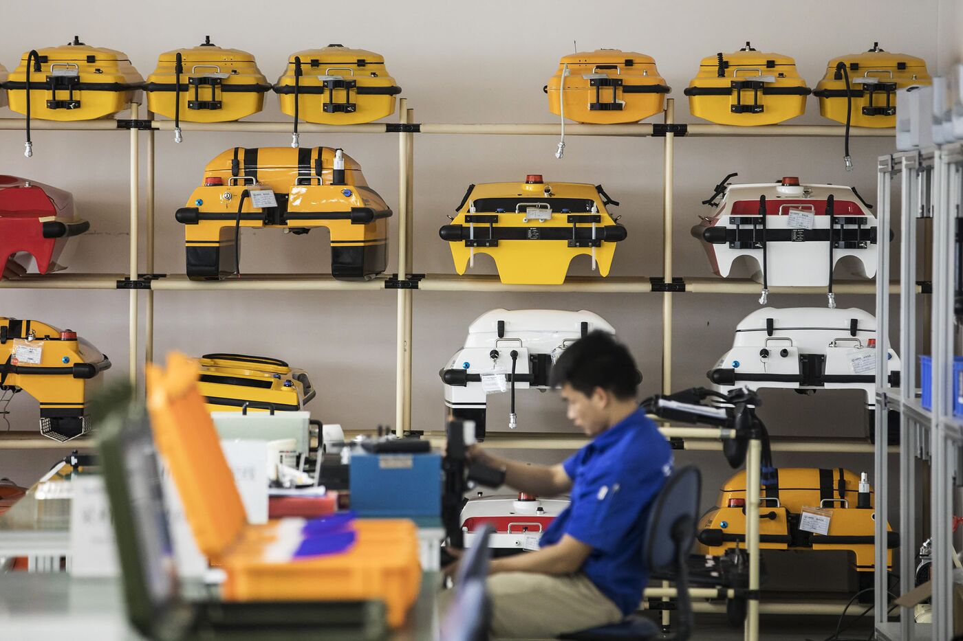
Drones on a rack at Oceanalpha’s facility in Zhuhai.
Photographer: Qilai Shen/Bloomberg
Photographer: Qilai Shen/Bloomberg
“If you look at Chinese traditional culture, we’re not as close to the ocean as Western countries.
But now we’re getting closer,” Zhang, 34, said at his offices in Zhuhai, a seaside city next to Macau.
“We want to change the relationship that human beings have with the sea."
Outside, workers are building the company’s new $40 million waterfront headquarters on land leased at a steep discount from the government, fashioned like a giant 10-story catamaran, including topographical pools for testing.
Alongside a private dock are prototypes of various sizes, from boats that can fit several people to motorized life savers for rescue missions.
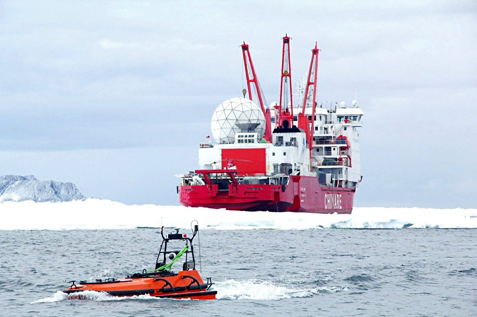
Oceanalpha's drone with the "Snow Dragon" icebreaker in Antarctica.
Source: Oceanalpha
Source: Oceanalpha
While Shenzhen-based DJI led the charge in the competitive consumer market for aerial drones and China has used unmanned submersibles to probe the depths of the South China Sea, Oceanalpha is one of a handful of companies around the globe specializing in ocean-going drones that operate on the surface.
“Zhang found a unique niche,” said Derrick Xiong, a co-founder of EHang Inc., which is developing aerial drones for swarms, deliveries and air taxis in nearby Guangzhou.
Oceanalpha’s advantage is being in China, where capital is readily available and leader Xi Jinping is promoting both technology to move up the manufacturing value chain and maritime industries to enhance the nation’s overseas interests.
As its trading empire has grown, so has China’s interest in the oceans, with the construction of a modern navy, trading ports and an armada of merchant vessels.
It’s a turnaround from what China’s textbooks call the “century of humiliation,” when the nation’s weakness at sea allowed a period of foreign interventions beginning with the Opium Wars.
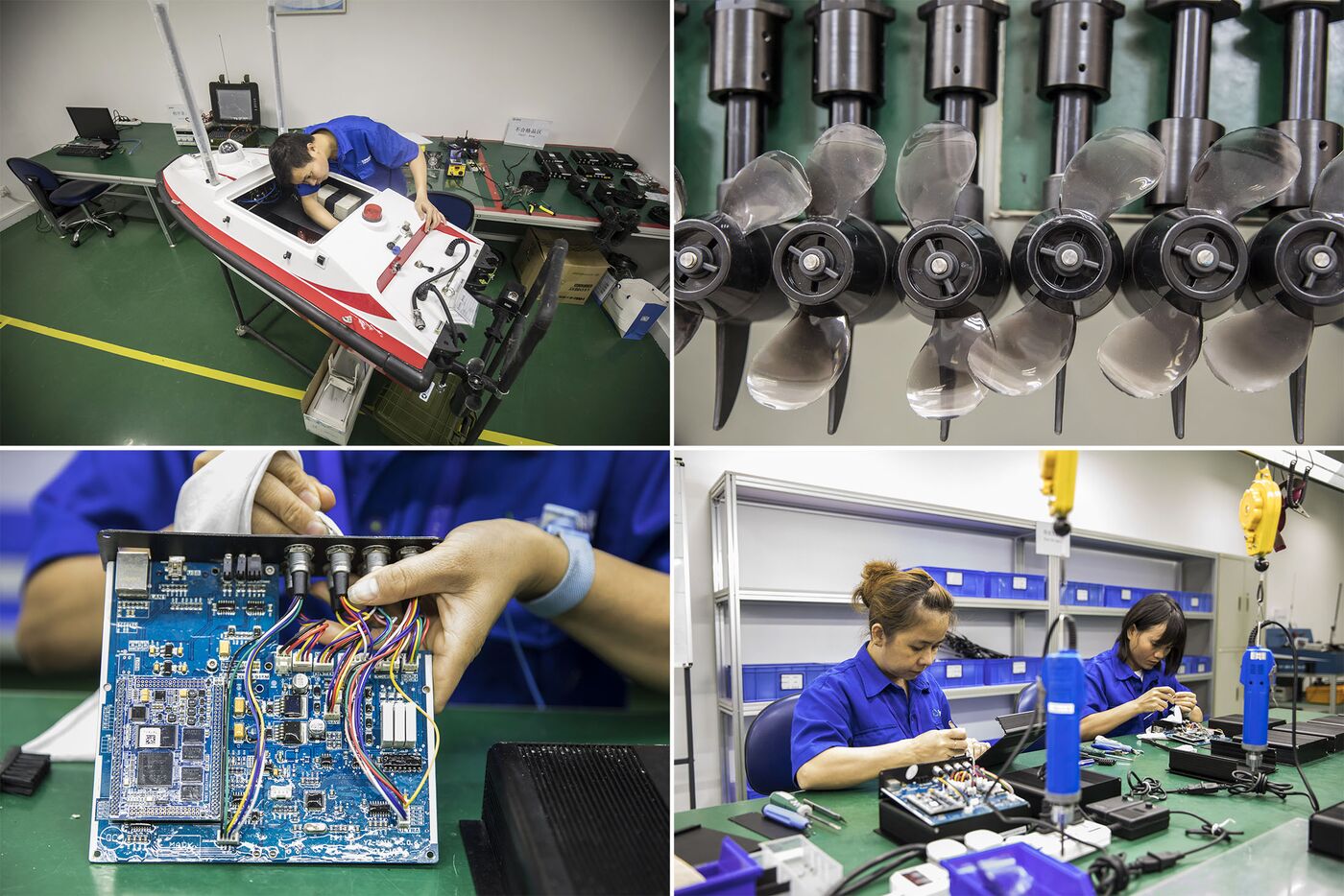
Top: A technician builds a vessel at the company’s facility.
Bottom: Workers assemble main control modules.
Photographer: Qilai Shen/Bloomberg
Photographer: Qilai Shen/Bloomberg
Zhang says venture capitalists began hounding him ever since his start-up won the China Innovation & Entrepreneurship competition in 2013.
Zhen Fund and GGV Capital are both investors.
Now, after nearly a decade focusing on research and development, Oceanalpha is expanding from water sampling and hydrological surveys into search and rescue, surveillance and other segments.
The company may seek a public listing after 2020.
The big prize is cargo.
Zhang has a new partnership with Wuhan University of Technology, China’s Classification Society and Zhuhai municipal government that will use artificial intelligence to direct autonomous container vessels.
“There will be a huge revolution in the maritime industry within three years,” Zhang said.
“Cargo ships will be autonomous before cars.”
The project, called Cloudrift — a reference to the Chinese legend of the monkey king, who could summon a cloud on which he traveled — is racing against rivals to build an unmanned cargo ship this year.
Norway has created a test area for pilotless vessels in the Trondheim Fjord in a joint effort by the Norwegian University of Science Technology and companies including Rolls Royce.
Cloudrift’s ship would be battery powered and use China’s BeiDou satellite navigation system.
The 50-meter vessel would have a loading capacity of 500 metric tons and a range of 500 nautical miles per charge.
The company is building a test site of its own among islands about 50 kilometers from Zhuhai and the group is investing $10 million in cargo technology and $50 million in USV field-test development.
Zhang is in the right place.
Zhuhai was one of the fastest-growing commercial ports in China last year and the Pearl River Delta, now calling itself the Greater Bay Area as it turns high-tech, is one of China’s two giant logistics regions for container ships, along with the area around Shanghai.
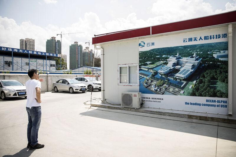
A poster featuring the new Oceanalpha headquarters in Zhuhai.
Photographer: Qilai Shen/Bloomberg
Photographer: Qilai Shen/Bloomberg
Raised largely in Shenzhen by parents who worked at state-owned Chinese IT companies, Zhang’s path into boat drones began across the bay at Hong Kong University of Science and Technology, whose alumni include Frank Wang, founder of DJI and the first drone billionaire.
Zhang and two PhD schoolmates, Cheng Liang and Wang Mingyu, convinced a chemistry professor to sell them sensors, which they mounted on a prototype to test the local seawater.
The three went on to found Oceanalpha, which now employs 260 people.
Wang later left to join DJI.
Cheng is general manager at Oceanalpha.
Technicians test Oceanalpha drones on a pond at the company's office in Zhuhai.
Photographer: Qilai Shen/Bloomberg
Photographer: Qilai Shen/Bloomberg
With the results of the university project, Zhang went on the road in 2009 for 10 months, showing local environmental agencies in nearly a dozen provinces how the vessels could help them collect water samples.
He scored deals and started making boats that could suck water samples up through the hull and detect illegal pipelines spewing effluent into rivers.
“That trip gave us the confidence that the market needs this kind of technology,” he said over sugary coffee with milk and platefuls of toffee candies.
Water sampling and hydrological surveying for government agencies and local authorities gave Oceanalpha cashflow to support research and explore other opportunities, including surveillance.
In the factory paint shop, where workers put the finishing touches to different colored drones, a camouflaged version will help China’s Coast Guard monitor port security.
A recent tie-up with industry giant Teledyne Technologies Inc. will also explore strategic opportunities, Zhang said.
The Thousand Oaks, California-based company didn’t respond to a request for comment.
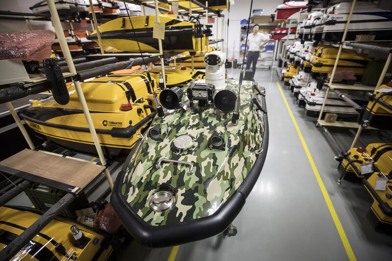
A camouflaged boat drone at Oceanalpha’s facility.
Photographer: Qilai Shen/Bloomberg
Photographer: Qilai Shen/Bloomberg
But its Zhang’s ties with Chinese government agencies that remain the impetus behind the company, in which the Zhuhai government holds a small stake.
A wall of awards in his office shows photographs of Zhang with high-level Party officials.
In one, he hands a model drone to Premier Li Keqiang in front of Russian Prime Minister Dmitry Medvedev.
Li heads China’s Made in 2025 initiative, which targets 10 areas for innovation, including maritime engineering.
The program’s subsidies have become a point of tension in U.S.-China trade talks.
One day Zhang hopes to have a picture with Xi, who may lead the country beyond 2023 after China recently scrapped presidential term limits.
“Perhaps you’ll see it next time you visit,” he said.
Links :
- The Star Online : Robot boats propel one of China’s hottest startups
- Hydro : OceanAlpha Delivers Innovative USV Solution to Mining Industry
- The Maritime Executive : Chinese Shipbuilders Pursue Vessel Autonomy
- OpenGov Asia : China building test site for unmanned ships in Guangdong Province
Monday, June 4, 2018
Why melting icebergs don’t affect sea level
Images of icebergs melting or the disappearing sea ice in the Arctic are generally associated with rising sea level – a widely-held belief that is simply not true.
Though many of my regular blog readers know this, over the last several years I have presented to hundreds of audiences.

A freshwater ice cube floats in a beaker of concentrated saltwater.
Note
that the ice cube floats much higher in the saltwater than it would in a
glass of freshwater because saltwater has a greater density.

When the freshwater ice melts, it raises the water level.
Freshwater is
not as dense as saltwater; so the floating ice cube displaced less
volume than it contributed once it melted.
Nearly everyone is surprised to learn that floating ice has no effect on sea level as it melts.
I usually explain it with a reference to Archimedes Principle, or a simple demonstration of ice cubes floating in a glass.
But the other day, talking to a small group in San Francisco, it occurred to me that I often do not explain the science behind why melting ice does not raise water level, so that is my topic for this week. As most substances cool, the molecules become more tightly packed, making the material “denser.”
In a liquid, dense objects sink to the bottom.
Through most of its temperature range, water gets more dense as it cools.

As the Arctic and Antarctic melt, there are more icebergs.
Surprisingly,
they do not add to sea level as they melt.
(Photo credit: Clemens
Vanderwerf)
So for example, colder water in oceans and lakes will normally be found near the bottom.
However as water cools towards freezing, at about 39 degree Fahrenheit, or 4 degrees Celsius, water does something strange and extraordinary: it gets less dense.
Technically it’s because the totally fluid water molecules which are tightly packed, transform into the very rigid crystal structure of ice, which occupies more space.
In fact ice is almost 9% less dense than the water that forms it.
As a result ice floats.
Saltwater is a few percent more dense than freshwater due to the dissolved minerals, the “salts.” Icebergs that calve off from glaciers are almost pure freshwater, since the glaciers largely result from snowfall.
Thus freshwater icebergs rise even a little more than nine percent above the ocean surface.
This is the typical rule-of-thumb that icebergs are roughly ten percent above the surface and ninety percent below.
As icebergs melt and the water warms back into the “normal” ocean temperature range above 39 degrees F (4 degrees C) the density increases, reducing the volume.
As a result, the actual melting of ice does not add to the level of the water – regardless whether the liquid is your glass of iced tea, or the ocean – though it does defy intuition and seems perplexing.
It is truly one of nature’s phenomena.
Understanding that melting icebergs and even the sea ice in the Arctic Ocean and the marine ice shelves in Antarctica do not add to sea level rise is important in the growing debate and understanding about rising sea level.
At the global level, rising sea level is primarily caused by ice on land melting, mostly from Greenland and Antarctica, either in the form of: meltwater flowing to the ocean, in some cases essentially as rivers, adding to sea level, (just as adding water to a glass adds to the level), or large pieces of ice break off from a glacier and enter the sea, becoming a new iceberg.
Any new icebergs entering the ocean, they do add to sea level adding more than 90% of their volume, (just as adding an ice cube adds to the level of water in a glass).
Another factor in sea level rise, not as obvious as the above two forms, is something called thermal expansion of seawater.
Again referring back to the previous description that warmer substances normally expand, including water above 39 degrees F (4 degrees C) the warming ocean is slightly expanding because global average temperature is now measurably higher.
Average global temperature today is approximately 16 degrees Celsius (60.5 degrees Fahrenheit) an increase of roughly one degree Celsius from the pre-industrial era.
In addition to those global factors of rising sea level, there are regional and local reasons for sea level to change.
Most commonly, land subsidence or uplift – land actually moving downward or upwards, due to movements of the earth’s crust or compaction of silts, can add to or subtract from global sea level rise.
(Examples: Jakarta and New Orleans have had extreme subsidence and higher sea level; Alaska and Scandinavia have generally had land uplifting causing sea level to fall slightly.)
There are many factors that contribute to sea level rise, but melting icebergs and sea ice are not among them.
It is important that we avoid the confusion and keep the world’s focus on what will increase sea level – fundamentally it is the warming global temperature, with the greatest effect being the melting of the glaciers and ice sheets on land, entering the sea as new icebergs or meltwater.
Links :
Sunday, June 3, 2018
The greatest rides from maxing Cloudbreak May 26th-27th, 2018
Minds were blown as the highlight clips trickled in during the mega swell that hit Fiji this past weekend.
From the viral moments like Ramon Navarro’s massive tube and Makua Rothman’s foamball pitch, to unseen footage of the heavy paddle sessions, watch three minutes of the hard-charging glory and carnage that transpired at maxing Cloudbreak.
Featuring Ramon Navarro, Billy Kemper, Landon McNamara, Kelly Slater, Luke Shepardson, Nathan Florence, Evan Valiere, Laurie Towner, Makua Rothman, Koa Rothman, Sai Smiley, and a handful of other chargers.
 Swellnet : Analysis: New buoy records Fiji swells
Featuring Ramon Navarro, Billy Kemper, Landon McNamara, Kelly Slater, Luke Shepardson, Nathan Florence, Evan Valiere, Laurie Towner, Makua Rothman, Koa Rothman, Sai Smiley, and a handful of other chargers.
Subscribe to:
Posts (Atom)