Saturday, April 9, 2022

Curiosities at the chart makers Imray

From Yachting Monthly by Katy Stickland
 
Katy Stickland goes behind the scenes at Imray and discovers the treasures held by the nautical publisher
 
‘Great Andaman where Inhabitants are said to be Cannibals’.
These ominous words hang in the air, which is thick with the smell of old paper, ink and dust as we gingerly leaf through piles of ‘blueback’ charts in the basement of Imray, Laurie, Norie and Wilson Ltd.

Yachting Monthly is being given a tour of the nautical publisher’s HQ in Wych House in St Ives, Cambridgeshire.

We are poring over some of the company’s oldest charts including this one from 1784 of Andaman and the Nicobar Islands in the Indian Ocean.

The chart is marked in black and red ink, with everything in red highlighting an amendment.

Old Imray chart of the Andaman Islands
A 1784 chart of the Andaman Islands with amendments in red ink. Credit: Katy Stickland

It also includes remarks from one Captain Phineas Hunt, detailing the Nicobar Islands’ channels and harbours as well as where there is an ‘abundance of Hogs & Fowls’, vital information for Merchant Navy ship captains in the 18th and 19th centuries.

Although Imray as it is today was incorporated in 1904, the roots of the three chart publishers that formed it – James Imray & Son, Norie & Wilson and RH Laurie – can be traced back to the mid 1700s.

For centuries these London-based firms, along with a few other companies, were responsible for producing what became known as blueback charts because of the distinct blue manila paper which was used to back them.

This not only strengthened but also distinguished them from the British Admiralty charts, which were published on heavier-weight paper.

These privately printed charts were mainly used by the Merchant Navy; publications for recreational sailors only really became available from the 1890s.

Old charts at Imray
Imray director Lucy Wilsons shows YM some of the firm’s old blueback charts.
Credit: Theo Stocker

By then, competition from Admiralty charts was damaging the traditional private chart trade, a threat that would eventually lead to the amalgamation of the three firms.

It was Norie & Wilson which took the prudent step in publishing Fore and Aft Seamanship for Yachtsmen: With Names of Ropes, Sails, and Spars in a Cutter, Yawl, or Schooner in 1878.

But it wasn’t until after the First World War that recreational sailing started to become the focus of Imray’s business, partly because of the growth of yachting in the UK.

The C and Y series charts were launched in the late 1920s.

Opposite Wych House’s basement are a framed 1962 C4 chart of the Needles Channel to Portland, and a 1947 chart of the London Docks and the River Thames.

Decades later, the yellow and green colouring on the C4 is still almost psychedelic, competing for eye gaze with the vibrant reds and greens used for colouring the London chart.

Old Imray chart
Some of the early charts feature the routes of ships

The C4 also has some of the same features of the original bluebacks.

Within the chart are smaller charts for Weymouth Harbour, Christchurch and Lulworth Cove.

The addition of large scale harbour plans were always considered good value for money by Merchant seamen, as it meant they didn’t have to buy additional charts, a continuation which was warmly welcomed by recreational sailors.

Today, Imray C charts cover the whole of the British Isles and parts of Europe.

Imray also rewrote some of its pilot books to include anchorages and passages accessible by smaller sailing boats.

modern Imray chart
Imray still retains the ethos of its founders: to produce charts using accurate hydrographic data

Previously, pilot books had just concentrated on the needs of larger ships.

The Pilot’s Guide to the English Channel and The Pilot’s Guide to the Thames Estuary and the Norfolk Broads were both rewritten by Eric Wilson and published in 1932 and 1934.

The initial success of Imray’s foray into the yachting market was abruptly halted by the start of the Second World War, which saw Imray move its offices from London to Cambridgeshire.

St Ives was chosen because the print works Enderby & Co were based there, and it had lithographic printers large enough to print charts.

Norie's Nautical Tables
Modern and older versions of Norie’s Nautical Tables for astro navigation

Throughout the 1960s and 1970s Imray established itself as a publisher for cruising sailors.

It started producing folded charts, and in 1979 ended the lining of charts with blue manila paper.

In 1999, the first digitally drawn charts using GIS (geographic information system) software were produced.

Recently Imray has undergone another major change in its production system allowing it to develop new products such as Imray Electronic Navigation Charts (ENCs), update products more frequently, align book, chart and digital products more closely with each other and receive and manipulate data more easily.

Despite advances in technology, Imray still retains the ethos of those three original publishers: to produce charts using accurate hydrographic data.

It is appropriate our tour ends in the boardroom, where the portraits of those early founders stare down at us, alongside the tools of their trade.

The brass protractor belonging to Norie’s founder William Heather; Lord Nelson’s favourite chair which was given to Heather by a friend who served with Nelson on the HMS Boreas and the early editions of Norie’s Nautical Tables, still produced by the company.

Links :

Circumnavigate : the story of the Long Paddle trailer

Adventure SUP Documentary from Will Reddaway
Stand up paddleboard adventurer Brendon Prince embarks on a never before completed challenge to circumnavigate mainland Britain. 

Friday, April 8, 2022

Great seamanship: Taken by the wind


Tom Cunliffe introduces and extract from Taken by the Wind
Memoirs of a 1970s pacific voyage, which reveals a time when sailors had to rely on their own pilotage skills for safe passage
 
From YachtingWorld by Tom Cunliffe


Mike Jacker is a retired orthopaedic surgeon living in Illinois.
Among many other activities he still sails his boat, now mainly on Lake Michigan, but he has a long memory.
In 1976, shortly after graduating from college, he and two friends set off in a Cal 30 production yacht from New Orleans for a year’s cruise in the South Pacific.

The unusual thing about his account of this voyage is that it was not written until 2020, looking back on a different age with all the wisdom of a life fully lived.

I sailed away into the blue myself at the same time, and I find his notes on the total lack of backup, no weather forecasting, no GPS and no communication with the outside world, ring absolutely true. Nobody sailing with all the benefits available in the modern world should forget that, just one lifetime ago, things were very different indeed.

We join Mike and his shipmates leaving Belize, bound on a tricky traverse to Panama…

Taken by the Wind extract


On 15 September 1976, we cast off Rhiannon’s dock lines and cleared the mud bar at the mouth of Haulover Creek.
We were officially destined for the Panama Canal Zone, conservatively estimating arrival within two weeks.
We had already learned from experience that potential calms, equipment failures, and headwinds precluded overly optimistic predictions for any passage.

In letters mailed from Belize to our families back home, we even added a few extra days to our estimates.
We never wanted relatives to believe that we might be overdue in port.
If we did not contact them when they expected, we feared that perhaps they might initiate some sort of search for us; we were already dealing with enough angst of our own without any added concerns about someone launching an unwarranted search.


Mike Jacker taking a sun sight in the Pacific

We never filed any sort of float plan or formal itinerary. In most places we were travelling, no organised search agency or rescue authority even existed.
Louis, Clark, and I knew that we were always alone, dependent on our own ingenuity and the limited resources of our fragile little boat.

A quick glance at any map or nautical chart of the Western Caribbean immediately reveals the most prominent coastal feature.
The eastern point of land in Central America where the Coco River forms the border between Honduras and Nicaragua, is a cape known as Cabo Gracias a Dios.
When voyaging south­ward along the Central American coast, one must travel eastward against the prevailing contrary wind and current to pass this formidable promontory.

The name, meaning ‘Thanks to God’, is attributed to Christopher Columbus.
On his fourth voyage in 1502, coincidentally also during September, Columbus required 29 days of rough sailing to reach this cape from Trujillo on the northern Honduras coast.
He endured horrible storms and endless headwinds before finally turning south into fair weather.
The passage was so miserable, even for the great ‘Admiral of the Ocean Seas’, that he gave thanks to God for rounding this point of land. Louis, Clark, and I were not bold explorers, but we fully understood the reputation of Cabo Gracias a Dios and girded our loins for the impending battle.

Our course took us toward the south-east after passing the south end of Turneffe Island. Cabo Gracias a Dios lay some 325 miles away.
We remained well offshore of Glover Reef, attempting to make as much easting as possible.
We then continued south on a port tack in moderate south-east winds.
On the second evening I noted that ‘we saw a magnificent rainbow, a meteor that lit up the area as day… and several flying fish landed on the deck’.


Clark and Mike sailing in the Marquesas

Later that night we tacked back and forth, rail down, as we were struck by intermittent gusty squalls packing 35-knot winds.
Rhiannon punched into the steep waves.
Despite the slog, we only made 10 miles of easting all night. During that night, we spoke to a nearby freighter by radio.
They provided a favourable weather forecast for the next day.
This was welcome news, especially considering our disheartening progress.

The following day we reached the Bay Islands of Honduras: Roatan and Guanaja. In the distance, a rain squall including a waterspout was drifting away, leaving us in fair weather.
With our track leading directly toward the gap between the two verdant Bay Islands, we held our course, cautiously avoiding the shoals east of Roatan.

That morning the sailing was perfect!
The sea was absolutely calm, the air was warm, the skies were clear, and the islands looked magnificent.
We saw no other people or vessels, even as we later tacked toward the east, following the south shore of Guanaja.

Paradise islands

This was our first taste of enjoying an idyllic paradise all to ourselves.
Our thoughts turned in awe to the feats of the early European explorers who, amazingly, had sailed through these same waters, without even a chart.
We had no clue of the tourist playground that this virgin region would become in the following decades.
I noted in my journal that if severe weather were to crop up over the following days, we knew of a place where we could easily return to seek shelter.

After passing the Bay Islands, we continued to tack eastwards, experiencing rain squalls alternating with calms.
On the short-wave receiver we were able to pick up the Caribbean weather forecast from Miami relayed through a repeater on Swan Island.
Thankfully, there were no storms predicted for the following three days.

On September 18, during one of several rain squalls, Clark suddenly called out, “What was that?!… I just saw a huge dorsal fin.” Louis and I wore eye-glasses, so could see little through our rain-covered lenses and even less with our glasses removed.
Nonetheless, I also soon spotted our visitors. It was a pod of small black whales.
Their smooth, sleek backs repeatedly broke the surface as close as 10ft from our starboard beam. Although we could not identify them at the time, these most likely were pilot whales.


Rhiannon at Bora Bora

They disappeared as quickly as they’d arrived.
We sighted no other whales during our time in the Caribbean.
In 1976, populations of the great whales had become alarmingly small, as most species had been decimated by the whaling factory ships prowling the oceans at that time.

Unlike whales, dolphins were more abundant in the 1970s than they are today.
Over-fishing had not yet critically depleted their food sources.
Dolphins have always been man’s greatest companions at sea.
They consistently thrilled us whenever they arrived.

Sometimes solitary but usually in groups, dolphins loved to play around the bow wave, dive beneath the keel, and perform acrobatics while keeping pace alongside the boat.
I was always delighted by the random appearance of dolphins during my night watches.
Frequently, I would be alerted unexpectedly to their presence by the characteristic breathy ‘puh-heee’ sound of a dolphin exhaling and inhaling as it broke the surface.
Soon others would join the first one, cheering me through my night watch.
Often, the lively underwater chatter of a pod would reverberate loudly through Rhiannon’s resonant hull, waking the off watch as well.

During this passage, I became acutely aware of the pelagic birds, the flying fish, and the leaping tunas, as well as the playful cetaceans that entered our world.
In truth we were the strangers invading their world, aliens to the sea.
But, occasionally, other members of the land-based world also paid us a visit.
Fishing boats frequently appeared and disappeared over the horizon as we neared coasts.
Aircraft contrails occasionally crossed the sky.


Rhiannon in the Panama Canal

However, to me, the most notable visitors were the ones who, like us, were most removed from their own element.
I easily empathised with the shore birds that had been lost or blown off course, ending up at sea.

I imagine that those birds, not accustomed to long overwater migration, would often meet death in the waves as soon as they became exhausted.
A few were lucky and found Rhiannon, the witch, transporting her own ‘three birds’.

Off the coast of Honduras, just beyond sight of land, on September 18, two small land birds came aboard.
One was a finch, and the other a smaller yellow-throated bird.
They walked over Clark as he lounged in the cockpit and took turns exploring the cabin.
As we tacked back toward the coast, they swiftly departed the moment land was in sight.
These visits aboard our floating home were always magically uplifting.

Storms avoided


Fortunately, we never met the fierce storms and daunting conditions described by Christopher Columbus.
However, consistent east winds forced us to tack back and forth repeatedly.
All afternoon on September 19, we could see a headland that we had hoped was the fabled cape.
But as we drew near, the contours of the coast and alignment of the shore informed us instead that this was Cabo Falso, the ‘false cape’ that had given Columbus false hope of having reached the true eastern promontory.

Beyond Cabo Falso, with 21 miles left to Gracias a Dios, we tacked to within 100 yards of the beach just before sunset.
A lone man was walking at water’s edge along the calm seashore.
Even though we’d been sailing for four days and were so close to the Honduran coast, we did not land.
As darkness fell, we cautiously came about onto starboard tack to head back offshore.
As long as the wind blew, we needed to continue toward Panama without stopping.

Louis tending lines on the foredeck in the Panama Canal

We then faced our greatest navigational dilemma thus far.
The sky had become overcast, and the wind had backed slightly to the north-east at about 15 knots.
This wind was perfect for a night rounding of the Cape.

However, there were no lighthouses, buoys, or other aids to navigation.
The charts indicated multiple areas of shoal water inshore, as well as many small reefs and islets, called Miskito Cays, extending well offshore from the Cape.
A cloudy sky prohibited celestial navigation.

Coastal piloting without any visible landmarks on shore would have been impossible in the dark.
We knew that dead reckoning using the compass would surely be helpful.
But strong, uncharted currents of uncertain direction precluded safe rounding of the Cape using only the compass and sumlog.
Unfortunately, the nearest radio beacons were scores of miles away.

Therefore, we carefully studied the charts to consider our alternatives.
One plan would involve sailing far offshore, bypassing all the hazards near the coast. But that would add a full day to our trip.


The sailing attire of the time protects against squalls
 
Following the contours

Just then I saw another possible way forward.
I ran my idea past Louis and Clark. A contour line on the chart denoting a depth of four fathoms (24ft, or 7m) described a broad, meandering arc that rounded the entire Cape while threading between all the obstacles.
The north-east wind would enable us to navigate the entire passage, sailing on a comfortable reach. We all agreed this would be our plan.
Next, we confirmed that our depth sounder was functioning properly.
Just in case the depth sounder might fail, we readied our lead line as a backup.

The flashing red dot on the face of the circular depth sounder indicated we were in 50ft of water.
We eased the sails, falling off toward shore.
Slowly, the bottom rose toward Rhiannon’s keel as we met the shallow water.
At just under 25ft, we intercepted the imaginary four-fathom contour line and adjusted our course.

For the next four hours, all three of us remained vigilant on deck.
We passed several unlit fishing stakes but otherwise kept well clear of hazards, as we walked a virtual tightrope between the prominent point and the treacherous reefs.
Once we had successfully passed Cabo Gracias a Dios, feeling immense relief, we set our course offshore, toward Panama. Louis, Clark, and I had accomplished in days what had taken Columbus weeks.

Thursday, April 7, 2022

Cuba (GeoCuba) layer update in the GeoGarage platform


 20 nautical raster charts added

1855 (Direccion de Hidrografia de España)
source : CNIG

Links :

ArcticInfo ‒ A digital service for safer seaborne voyages in the Arctic


From Framsenteret by Anders Røeggen // BarentsWatch and Anne Grethe Nilsen // Norwegian Coastal Administration

ArcticInfo provides important information on sailing conditions in the Arctic, supporting decisions for safer navigation in Arctic waters.
Map-based and accessible to all, ArcticInfo covers large areas off the coasts of Norway, Iceland, Russia, Canada, and Greenland, plus the Barents and North Seas.

Low temperatures and extreme weather conditions, limited daylight over long periods of time, limited communication and infrastructure, poor charts, and large distances are some of the challenges that navigators face in Arctic waters.
On top of this, there are almost always very limited resources nearby if accidents occur.
To strengthen maritime safety and protect the environment, the Norwegian Coastal Administration has gathered voyage-related information in one place: ArcticInfo, available via BarentsWatch.

Users must register to get full access to the service, though much information is available without registration.
Registered users can edit data about their own vessel, such as maximum speed, ice class, gross tonnage, rescue capacity, communication capabilities, helicopter deck, and a doctor/nurse onboard.
 
 
 The actual framework of the service is the map, which shows a number of layers of data that the user has easily accessible.
Illustration: BarentsWatch

ArcticInfo provides information about icebergs around Greenland, icing, ice concentration from the Meteorological Institute in Denmark and Norway (drift ice and solid ice), storm warnings for Norway, Canada, Iceland, and Russia.
Weather stations and ship information based on AIS (Automatic Identification System) from the Norwegian Coastal Administration are included.

“We want to offer a regularly improved service that can support navigators in making well deliberated and safe choices along the way,” explains Jon Leon Ervik, Head of the Department for Navigation Technology and Pilotage Management at the Norwegian Coastal Administration.

Maps showing the ice edge, wind, current and temperature, depth curves, quay conditions, and Norwegian maritime borders are included in the service.
You will find an option to send your voyage plan digitally to the Greenlandic authorities.
 
A user-based service

Since its launch in early 2020, ArcticInfo’s user group has proven to be very diverse.
A starting point for the service was the increasing cruise traffic prior to the Covid-19 pandemic, but fishing boats, the coast guard, and research and expedition vessels have used the information service.

Taitsianguaq Olsen is a marine pilot based in Nuuk, and co-owner of the company Imaq Pilot.
In addition to pilot assignments, they offer services for mariners in relation to the Polar Code and a service for yachts and other larger recreational vessels.

“I use ArcticInfo to check vessel movements in the waters around Greenland,” says Olsen.
“Depending on the time of year, I use the function ‘Ice concentration’ to see the ice edge in the map.”

Olsen hopes to use the service more when cruise ships can once again sail along the coast of Greenland, hopefully from next year.

Terje Solberg Johansen from the Joint Arctic Command in the Faroe Islands says they use ArcticInfo as a supplement to other navigation equipment onboard their vessels.
“We especially use it in connection with AIS to see which vessels operate in the Faroese fisheries zone 200 nautical miles from the baseline and to the border to Norwegian waters. But, most of all, we use the service to see Danish navigation warnings for our area.”

The Faroese Command is based in Mjørkadalur on Streymoy.
It is the command authority of the Danish Armed Forces under the Danish Navy Operative Command. In addition to safeguarding the sovereignty of the Danish Commonwealth, they also carry out tasks such as fisheries inspection, search and rescue, medical transport, and other public service tasks.
 
 
Jon Leon Ervik, Head of the Department for Navigation Technology and Pilotage Management at the Norwegian Coastal Administration.
Photo: Anders Røeggen

The Arctic Monitoring and Assessment Programme (AMAP) is an international organisation that is now part of the Arctic Council, and aims to obtain information about the status of and threats to the Arctic environment.
“Together with many other partners, we carry out environmental assessments of the consequences of climate change in the Arctic Ocean. In this work, it is important for us to know how many and what types of vessels use the area,” explains Mario Acquarone at the AMAP Secretariat.

For the Norwegian Maritime Authority, ArcticInfo is also a useful tool.
“I plan on using the service to observe ship movements in the polar region, and to identify the conditions in areas where ships operate,” explains Port State Coordinator Bjørn Ove Hansen, who works with Port State Control.

Through the project “the Nansen Legacy”, Charlotte Stark, from UiT The Arctic University of Norway, uses ArcticInfo actively to encourage the public to follow the research vessel Kronprins Haakon on an expedition in the Barents Sea.
“We want interested parties to follow the vessel and see where it is. When scientists are on important missions in the Arctic, we share this information with people who follow the project, including on Facebook. We have tried to find a suitable service that could show the vessel in real time and came across the service from BarentsWatch, which is also easy to use,” says Stark.
“It’s nice to be able to follow the research vessel in an interactive map, which is available through the BarentsWatch service.”

Jon Leon Ervik greatly appreciates feedback from users.
“Our objective was to create an information service that provides navigators with important and useful information that supports safer voyages for navigators in the High North,” says Ervik. “The feedback we have received so far not only confirms that we are on the right track to that end, but that the service is also useful for others. Even though we have broad expertise that contributes to good decision-making in the Norwegian Coastal Administration, it is the feedback from users that ‒ ultimately ‒ will enable us to develop and deliver good services.”
 
Will further develop the service

The Danish Maritime Authority was to develop ArcticInfo, but due to reorganisation and lack of funds, the Norwegian Coastal Administration was asked to take over the development and operation of the information service.

“As this task was a perfect fit with BarentsWatch’s mandate, we agreed on a collaboration where BarentsWatch would develop the new information service based on data from the Norwegian Coastal Administration.”

Once conditions allow people to meet safely, the Norwegian Coastal Administration plans to host a user conference.
“We want a dialogue on how we can further develop the service to meet the needs of our users. Today, we have basic information that contributes to navigation safety and environmental protection, but there is great potential for creating an even better user experience. In the long term, we envisage integrating information that can support tourism, fisheries, cruise traffic, and public administration.”

Today, users can add important information for authorities responsible for emergency preparedness and search and rescue services in Arctic areas.
In the long term, the next step would be to add digital sailing routes for Svalbard, information about ice routes and icebergs, and whale observations.

“The service already includes Navigational Warnings and Notices to Mariners for Denmark, Greenland, and the Faroe Islands. We are now working to include similar information for Norwegian waters, and we hope to have this in place by the end of 2022. Our vision is a comprehensive and reliable information service where navigators can find important and useful information for safer voyages in the High North.”
 
Links :

Wednesday, April 6, 2022

Bristish Isles & misc. (UKHO) layer update in the GeoGarage platform

 
The North Sea, Ireland & the British Isles - 1865

The French Connection series in The Ocean Race

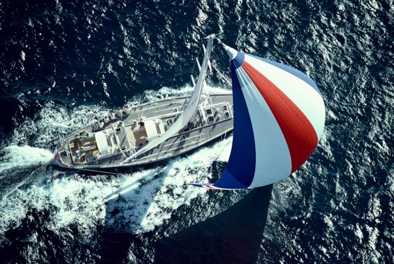
Sayula II, rounding Cape Horn, at the 1973-74 Whitbread Round the World Race
 © Bernardo Arsuaga Private Collection

From SailWorld part I / part II by The Ocean Race
 

part 1: Pioneers of the crewed round the world race

This is the first in a series of features celebrating the strong French heritage of The Ocean Race. Produced in cooperation with IMOCA Class, these stories highlight 50 years of the 'French Connection' dating back to the inception of the Whitbread Round the World Race in 1973.

In a year's time, they'll be riding the Indian Ocean swell in The Ocean Race (*) where the IMOCA Class is making its race debut, alongside the familiar VO65 one-designs. Spanning 12,750 miles, or 23,613 km, never before has one leg - between Cape Town in South Africa and Itajaí in Brazil - been so long.
Fifty years ago, sailors from all different backgrounds were competing in the very first crewed sprint around the planet known as the Whitbread Round the World Race.
Half a century on, IMOCA and The Ocean Race are rekindling their ties with this crazy epic in a bid to continue its legacy.

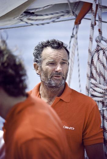
Eric Tabarly, skipper of Pen Duick VI for the 1973-74 inaugural edition of the race and legendary father of French sailing © www.pplmedia.com

On 8 September 1973, nineteen sailboats from seven nations, a third of which were French, set sail from Portsmouth and the green waters of the Solent bound for South Africa.
Not only was the atmosphere imbued with the inherent stress of any race start, but also a hefty dose of the unknown as the sailors had to negotiate a 27,000-mile sea passage, punctuated by the Roaring Forties and the Furious Fifties in the Indian and then the Pacific Ocean.
The story goes that a few years earlier, the former aviator Sir Francis Chichester, winner at sixty years of age of the first OSTAR, some four years before Eric Tabarly's triumph, came up with the idea of a crewed round-the-world race with some of the UK's leading lights, including Robin Knox-Johnston, winner of the Golden Globe in 1969, and Admiral Otto Steiner.
It was known as the Whitbread Round the World Race as it was sponsored by the famous British brewer.
This first marathon around the planet comprised four long legs from Portsmouth and back via Cape Town, Sydney and Rio.
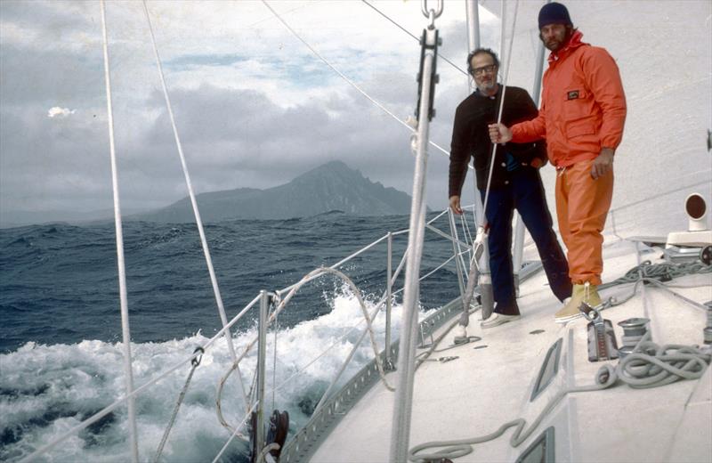
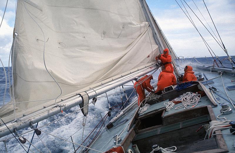
A certain black boat did not go unnoticed dockside. Pen Duick VI, a 22-metre ketch, was specially designed for the race by André Mauric and was equipped with a depleted uranium keel and titanium components.
The yacht was skippered by Eric Tabarly, who was accompanied by a young and talented crew whose names would soon be familiar to many - Olivier de Kersauson, Philippe Poupon and Marc Pajot...
The majority of the yachts were slow and heavy, loaded to the gunwales with tins of food and jerrycans of water.

Back in 1973, freeze-dried food and watermakers were not available on boats, but they did boast soft berths, back-up heating to try to dry vinyl oilskins from the fishing industry and even slippers.
Given the unreliability of the SSB communications, it was considered good form to have both a doctor on board - the future explorer Jean-Louis Etienne on Pen Duick for example - and a cook, who floated between watches and worked at the home-style galley stove.


Racer-cruiser yachts as strong as they are comfortable

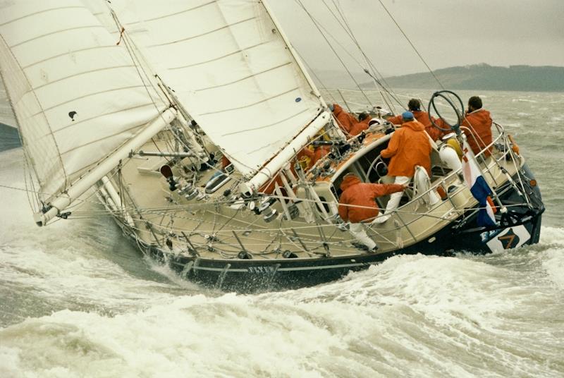
The British press promises an epic head-to-head battle between Eric Tabarly and Chay Blyth on Great Britain II.
Tabarly had become headline news when he took victory in the 1964 OSTAR, whilst former Paratrooper Blyth had won renown after setting a single-handed round-the-world record against the prevailing winds in a time of 292 days in 1971.
The two sailors were clearly in it to win it.
Recruited by Blyth, his crew were sturdy chaps but hardly sailors, and they complained of having to survive solely on stodgy curry-based meals.
It was borderline mutiny.
Upon making landfall in South Africa, Blyth admitted that "even parachutists are human beings...", which provides some insight into the atmosphere that had developed on board.

It was a very different scenario aboard Sayula II, a Swan 65, designed by the prestigious American firm Sparkman & Stephens, built in Finland and considered back then to be the Rolls Royce of racer-cruisers. Mexican billionaire Ramon Carlin had it all figured out.
He enlisted his son, an amateur yachtsman, but also some brilliant sailors.
Whilst the youngsters got on with the sailing on deck, the skipper and his guests made the most of it.
"We have alcohol aboard and we sometimes have a drink together after dinner or at the end of the watch when we're soaked and chilled to the bone", explained the bon viveur. "Some pay no heed whatsoever to the fact that we have some women aboard (notably Paquita his wife). Their presence in an excellent thing..." 
All the same, the legend doesn't really explain how many women there actually were on board and, ultimately, the preferred option was that all of them would step off the boat in Cape Town and join their spouses at the stopovers instead.

A 25-year-old fair-haired boy by the name of Peter Blake

Aboard Pen Duick VI, though, there's a guitar, songbooks and Châteauneuf du Pape - Tabarly's favourite wine - the accommodation is much less cosy, the crew opting to push the boat hard.
The on board footage shows the off-watch crew bounding up on deck in their underpants with no harnesses on to help douse the massive spinnaker during a broach in a fierce squall, the boat rolling from side to side.
It's a miracle that there aren't any casualties.
The race favourite will lose all hope of securing the win when the mast breaks and a new one had to be stepped in South Africa.
This was another crew who spent more time using their toolbox than racing.
On the British-flagged boat, a 25-year-old blond-haired New Zealander is competing in the first of his five consecutive Whitbreads. He goes by the name of Blake and he's enlisted as a general all-rounder.
In his logbook he says: "We've never sailed on this boat before and the race start heralds our first ever sea passage on her! We finish off the interior accommodation in the Solent.
Fortunately, the weather's fine...
However, we fail to check that the heads are disconnected and after a week at sea, we realise that everything's draining into the bilge where the tinned food is stored.
In the panic of the start, we've stowed the tins without referencing them and now the labels have come off so when we open one it's always a surprise!"

Philippe Facque: "I was 21 and I got the opportunity to race around the world!"


Following a month at sea, Sayula II takes the win on corrected time ahead of the comfortable Nicholson 55 named Adventure, and Grand Louis skippered by Frenchman André Viant.
Tragically, three souls are lost at sea, including Frenchman Dominique Guillet, co-skipper of 33 Export, and five boats fail to finish.
The race is merciless and the skipper of the Polish boat Otago, a good seaman but a registered amateur, says out loud what a lot of people are thinking: 
"It's really tough to live in such a limited space in very close quarters. Even rats couldn't live on top of one another like that without quarrelling from time to time!"


Listening to Philippe Facque, today the Managing Director of the CDK Technologies yard, and crew for André Viant in 1973, his memories have a rather different flavour.
Two years earlier, and much to the displeasure of his parents, he had traded his A-level oral exams for a shot at his first transatlantic sea passage. With André Viant quickly spotting his talent for driving a boat, he was offered a ride aboard Grand Louis for the first Whitbread.

"I was 21 years of age and I had the opportunity to race around the world. It was just great! In contrast with Kriter helmed by Jack Grout, which only had the big names aboard who didn't get on, there was a fantastic atmosphere on our boat and the unity and trust we felt are essential in a race like this. There were ten of us, with three people on watch at a time - one on deck, one on standby and one in the bunk. It was a mixed crew comprising the family of André Viant, a polytechnic graduate, company director and an incredible sailor - his daughters Françou and Sylvie, his son Jimmy and his son-in-law Michel Vanek... as well as young sailors like Loïc Caradec and me. Grand Louis was a comfortable schooner, but she was a sluggish tank. I recall cooking pancakes to kill time in the Indian Ocean... As it was the first race around the globe, everyone set sail with heavy, solid boats. We didn't know quite what to expect."

Today, despite running the CDK Technologies yard, which has built countless IMOCA yachts, including six Vendée Globe winners and the latest 11th Hour Racing Team, Philippe Facque has never sailed one of these boats. 
"What's amazing with these foilers is that they outperform the 60-foot ORMA trimarans from thirty years ago. These boats are fabulous, but with a crew of five in the Southern Ocean, it's bound to be full-on and physically demanding. These carbon hulls are incredible echo chambers. At the same time though, racing has become so much more professional in the past fifty years and today's sailors are meticulously prepared and even 'tougher' than we were. I sometimes wonder whether I'd enjoy a crewed round-the-world race on these extraordinary machines if I were their age today (he's now 70). I think I would... They go three times faster, they certainly do less cooking aboard than we did, but they get to experience what is an exceptional, unique and quite rare adventure," he concludes, laughing. 


part 2: The incredible technological laboratory
 
Flyer, winner of the 1977–78 Whitbread Round the World Race, skippered by Conny van Rietschoten
© PPL

Conny van Rietschoten © Christian Février

In part two of this series devoted to the history of the French in the round-the-world crewed race, IMOCA and The Ocean Race revisit the technological evolution that has coloured a race, which witnessed the first French victory in 1985-86 and the burgeoning career of a certain Franck Cammas.

When Mexican Ramon Carlin snatched glory in 1974 on the Swan 65 Sayula II, others were keen to emulate his performance.
Cornelis 'Conny' Van Rietschoten, a Dutch industrialist, began construction of a 20-metre Sparkman & Stephens ketch, a near sistership to Sayula, albeit made of aluminium, with a longer waterline and carrying more sail area.
Named Flyer, the ketch secured victory in the second Whitbread Round the World Race (1977-78) in 119 days.

By then the race had grabbed the attention of young naval architects, like New Zealanders Ron Holland and Bruce Farr, Frenchmen Philippe Briand, Gilles Vaton, Michel Joubert and Bernard Nivelt, as well as the Argentinian German Frers.
The Whitbread was not just a fantastic technological laboratory, but also a wonderful showcase for the major yards responsible for production cruising yachts like Nautor Swan, Bowman and Camper & Nicholson.
Some of the more notable innovations tested in the rigours of the Whitbread race included fractional rigs, rigid vangs, honeycomb core bulkheads and twin steering wheels.

In 1981, Rietschoten decided to defend his title with a new boat, Flyer II, designed by German Frers. Somewhat larger (23.16 m), the sloop was an example of the latest trend, fitting out a Maxi IOR (International Offshore Rule) to secure a win on both elapsed and corrected time.
His crew included Frenchman Daniel Wlochovski in charge of navigation, as well as a 20-year-old New Zealander, Grant Dalton, who designed the sails.

Heart attack in the Southern Ocean


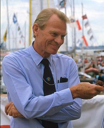
The race was not without incident however. In the South Pacific, Rietschoten came close to tragedy after suffering a heart attack.
The skipper forbade his crew from divulging this news and prevented the onboard doctor from contacting a colleague - who happened to be close by aboard rival boat Ceramco New Zealand, skippered by Peter Blake. 
"The Kiwis were hot on our heels", Rietschoten explained on his arrival dockside.
"Had they known that I had a health problem, they'd have pushed all the harder."
Miraculously, Rietschoten recovered and Flyer II took the race win, just ahead of Frenchman Alain Gabbay on Charles Heidsieck III and Kriter IX helmed by André Viant. 'Conny' is still the only skipper in history to have won two editions.


photo © DR The Ocean Race

Brittany's youth step up to the plate

Three Bretons, aged between 18 and 21, also had their hearts set on this legendary race.
Teaming up with Gabriel Guilly, they built a 'little' prototype in a shed in Etel in Brittany's Morbihan region.
She measured under fifteen metres and was designed by the Joubert-Nivelt pairing.
She went by the name Mor Bihan.
The trio signed up some renowned sailors: Eugène Riguidel, Philippe Poupon, Jean-François Coste, Halvard Mabire and Jean-François Le Mennec...
Nearly ten metres shorter than Flyer II, Mor Bihan bagged the win on corrected time in the third strenuous leg between Auckland and Mar del Plata.
Eugène Riguidel, skipper for this victorious leg via the Horn, said aloud what many others were thinking: "A race that pits such different boats against one another is doomed. An event with a fixed rating per category would be much better..."
He was proven right less than fifteen years later with the arrival of the VOR 60s.


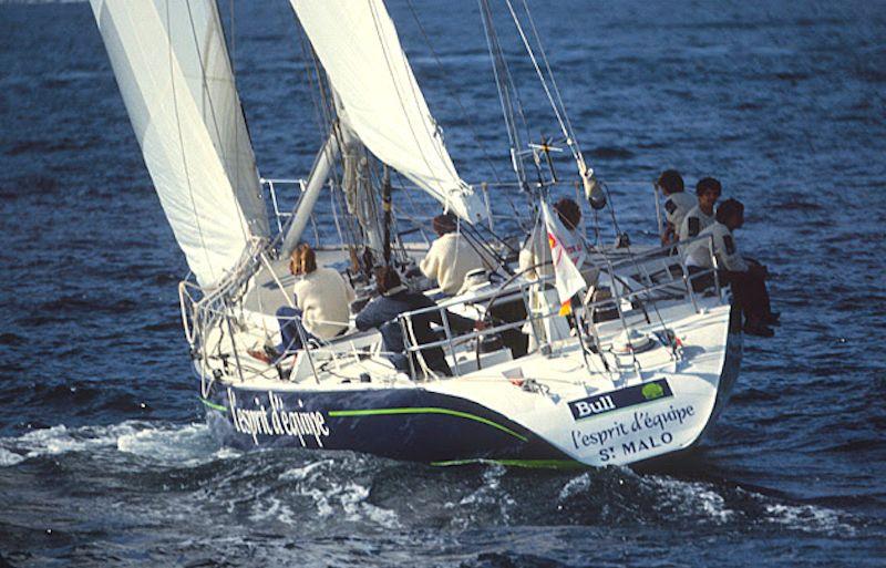
1986, Lionel Péan rather than Éric Tabarly

"The media and authorities hold a tremendous grudge against Bull - a nationalised French company specialising in professional computer systems - for favouring me over Éric Tabarly on his third participation", recalled Lionel Péan. Tabarly was after a Maxi - he had Côte d'Or built - and Bull thought, compared to their 'team spirit' slogan, 'L'Esprit d'Équipe', the double OSTAR champion had an image with a heavy singlehanded bias.

Péan continues: "I realised that the Whitbread wasn't won by the quickest boats, rather it favoured those who make good headway in relation to their handicap.
When we bought 33 Export designed by Philippe Briand, we clipped her wings."
The latter pair knew each other very well and liked one another.
In fact, Lionel went to the same secondary school as Philippe in La Rochelle.

"We had to increase the buoyancy between the measurement points. We kept the same sail area and increased the surface area of the keel, which meant we were highly versatile on every point of sail. It's worth noting that we still had Dacron sails back then. There was no carbon in the hulls. We also had halyards that were a mixture of wire and rope."

This strong skipper sailed with a group of seven young sailors.
He had a floating position aboard, as did the guy doing the cooking, rotating each day.
"We sailed our outward and return leg of the Atlantic at an average of 7.8 knots, and the two legs from Cape Town-Auckland and Auckland-Punta del Este at 9.8 knots, on a boat measuring just 56 feet and dating back to 1981.
Today, when you see the performances posted by IMOCAs, you get the sense that our boats were "Retromobiles"!

Everyone carried heavy packs of mineral water and tinned food galore, and we were the only ones to set sail with just an industrial watermaker.
It was enough to produce our water and prepare the freeze-dried food. In IOR, the boats were measured empty so it was important to keep weight to a minimum."

Seventeen days without seeing the horizon


"It was the early days of SATNAV and, when it worked, we had a position about every four hours... In the Deep South, upon setting sail from Auckland, we spent 17 days in a complete pea-souper, so it was impossible to use the sextant."

Before leaving New Zealand, Péan put an extra five spinnakers aboard, so he had eleven in all.
After completing a circumnavigation of the globe outstandingly well, Lionel Péan and his crew became the first French sailors to win the Whitbread, completing the course in 111 days.


Cammas discovers sailing through Tabarly's book about the Whitbread

Since its creation in 1973, the Whitbread has inspired a whole generation.
Such is the case for one young schoolboy born a year before the first edition, who loved hanging around in a bookshop in Aix-en-Provence after lessons
 He came across a book entitled "Le tour du monde de Pen Duick VI" (Pen Duick VI's circumnavigation of the globe) by Éric Tabarly, which his father gifted to him. 
"I'd never gone sailing in my life and I didn't understand much about it as there were a lot of technical terms. I re-read it three or four times over the summer whilst we spent our holidays in the Alps... with a dictionary to hand. I was so inspired by the book that I kept badgering my parents, who were more mountain than sea, to sign me up for a beginner's course on an Optimist in Marseille."

Not yet ten, this kid was called Franck Cammas.
From his opening tacks on the water, he was smitten, and onlookers were impressed by the speed with which he learned how to sail.
"Fairly quickly, I told myself that the most fantastic thing would be to compete in this race one day."
After his record-setting voyage in the Jules Verne Trophy and the Route du Rhum in 2010, the sailor from Aix-en-Provence was preparing to compete in the most prestigious of round-the-world races, the Volvo Ocean Race.

In preparation for the start, at the end of 2011, he acquired the winning boat from the previous edition, Ericsson.
He formed an entourage of specialists in the event, including a number of Anglo-Saxons to get a better understanding of the subtleties of this unique challenge, putting together a crew combining specialists from the round the world race, the Solitaire du Figaro and close-contact racing.
Cammas launched a new boat, Groupama 4 designed by his team and the Argentinian naval architect Juan Kouyoumdjian, who'd learned his craft with Philippe Briand.


Those familiar with the crewed round the world race weren't suspicious of this sailor.
He may have already earned a lot of wins in solo format, but this time he was discovering a world he didn't know. Indeed, during the first leg, he was still in learning mode.
With the passing miles though, Groupama 4 evolved and the team upped their game before taking the lead and winning the eighth and penultimate leg between Lisbon and Lorient...

During the French stopover, whilst the overseas crews headed off for a round of golf or to have some fun, Cammas and his team further optimised their boat, to the extent that they cut away the companionway steps to save a few extra grams before the final sprint to Galway.
The French team sailed an absolute blinder and Franck Cammas took victory in the Volvo Ocean Race in 2012, something which his idol Éric Tabarly was not able to do.

Aboard the boat was a certain Charles Caudrelier, helmsman-trimmer, who would go on to be promoted to the rank of skipper of Dongfeng Race Team, a French-Chinese campaign.
He too secured a win two editions later (2017-18) at the head of an accomplished international crew.
 
Links :

Tuesday, April 5, 2022

Antarctic ice shelves are shattering. How fast will seas rise?


The Thwaites ice shelf in West Antarctica is the floating end of the Thwaites Glacier, where the glacier flows into the sea. Already, about two-thirds of the ice shelf has fallen apart. 
n December 2021, scientists saw worrisome signs of disintegration in the remaining bit.
Ice shelves slow the flow of ice from land to sea, keeping sea level rise in check. 
Photo by Jim Yungel, NASA Earth Observatory

From National Geographic by Alejandra Borunda

An unexpected ice shelf collapse in East Antarctica, after temperatures spiked 70°F above normal, highlights bigger problems in the West, where one glacier could singlehandedly raise global sea levels several feet.

All scientist Erin Pettit could see when she looked at the satellite photos of the ice shelf in front of the Thwaites Glacier in West Antarctica was the giant crack that stretched across most of the image.

Two years before, when she and her colleagues were deciding where to put their research camp, the entire floating ice shelf—a tongue of ice poking out from the enormous glacier behind it—was solid.
It was plenty safe to plan a camp there, they thought.

But last December, when they were preparing to go to the camp, the images revealed enormous cracks in the ice pointing straight at it.

It was unlikely the cracks would grow fast enough to endanger them.
But to Pettit, it signified something even scarier: the start of ice shelf's disintegration, which is a step toward a larger disintegration of the glacier itself.

In March, East Antarctica—the other, colder side of the continent—saw its first-ever ice-shelf collapse.
As a late Austral summer heat wave brought extraordinary temperatures and high winds to the region, the Conger ice shelf disintegrated within days.
The unexpected collapse highlighted the importance of—and uncertainty about—the continent’s ice shelves, which act like bottle stoppers controlling the flow of ice from land to sea.
Their incipient demise, scientists fear, could be the beginning of more ice loss—and much more sea level rise that would affect countries all over the world.

Despite Conger’s collapse, the most pressing concern is still the ice shelves fringing West Antarctica, where Pettit works.
Their December 2021 discovery suggested the Thwaites ice shelf could disintegrate within the decade, leaving the enormous and unusually precarious glacier unprotected.
 
 
The size of Florida, the Thwaites Glacier holds enough ice to raise global sea levels two feet.
It’s also a bottleneck protecting the larger West Antarctic ice sheet, which would raise sea level 10 feet if it were to melt completely.
And because of some crucial, frightening quirks of geology and geography, Thwaites could one day become one of the most significant drivers of global sea level rise.
“It is the most important glacier in the world,” says Julia Wellner, a marine geologist at the University of Houston.

And the trajectory it seems to be on is “alarming,” says University of Colorado glaciologist Ted Scambos, who co-leads a major multi-year research program at Thwaites.
“All by itself, it could change the story. It could change the game of what we need to do by the end of the century” and beyond to adapt to sea level rise, he says—from building “hard” protection like seawalls or levees, to retreating from the coast.
 
NASA

Seas are rising now

Though a precise forecast is impossible, it's clear where sea level is headed: Up, possibly a lot, possibly soon.
Most coastal communities are struggling even to acknowledge the reality, says A.R. Siders, a sociologist at the University of Delaware.
“It’s not a question of if seas will rise two feet, it’s when. We just have to make the decision [to adapt], even with some uncertainty.”

Globally, seas have risen a little over 8 inches since 1900, but the rise is accelerating: A quarter of it has happened since 2006.
In the latest reportfrom the Intergovernmental Panel on Climate Change (IPCC), released in 2021, scientists determined global average sea level is now rising around 0.15 inch (3.7 millimeters) each year.
The IPCC projected with “medium confidence” that it would rise another 15 to 30 inches by 2100, and will keep rising for centuries.

Some regions are seeing a faster rise than the global average.
The U.S. East Coast, for example, is hit harder in part because the Gulf Stream is slowing and funneling less water away from the coast. U.S. coasts on average will likely see a foot of sea level rise by 2050 and two feet by 2100, the National Oceanic and Atmospheric Administration projected earlier this year.

Already, some 110 million people worldwide live in zones vulnerable to flooding by high tides.
With seas a foot higher, hundreds of thousands of U.S. homes on all its coasts, but particularly in the East and Gulf regions, could find themselves flooding as often as weekly.
Two feet would submerge much of the Maldives and other small island nations.

But even by 2100 the sea level rise could be greater than two feet. If we don’t control emissions and the planet warms 9ºF, the NOAA report says, there’s a 50 percent chance of seas rising more than three feet by 2100—and a 10 percent chance of them rising more than six feet.

The biggest source of uncertainty, aside from how fast we’ll choose to curtail emissions, is how fast an overheated ice sheet can crumble and melt—especially the Antarctic ice sheets, which hold enough water to raise sea level by 190 feet.

Billions of tons of Antarctic ice are already falling into the sea each year, but they contribute only a small fraction, about 10 percent, of total sea level rise.
The bulk of the rise comes from seawater expanding as it gets warmer, from mountain glaciers, and from melting Greenland ice, which will likely accelerate toward the end of the century.

Sometime in the future, Antarctica will also start discharging a lot more melt into the oceans.
The question is whether that change will take centuries to play out, reshaping coastlines slowly enough that communities might adapt, or whether it will happen faster.

But the dynamics of the ice shelves and glaciers are fiendishly difficult to predict, especially because warming of this speed and magnitude is unprecedented during the era of human observation.
"We are probably not going to definitively figure this out in the next few decades," says Bob Kopp, a sea level rise expert at Rutgers University.

In the meantime, he and other scientists fear, West Antarctica could cross a tipping point beyond which massive, accelerating ice loss becomes inevitable.
 

Sea ice area fraction in the Antarctic region, displayed on the Mercator Ocean MyOcean Viewer from September 2021 to February 2022.
Credit: Copernicus Marine Service
 
The vicious cycle threatening Thwaites

One place they are watching very closely for signs of catastrophe is the Thwaites Glacier, which is already responsible for 4 percent of global sea level rise.

Unlike most of the ice sheets in Greenland and East Antarctica, most of the West Antarctic one sits on bedrock that lies below sea level.
The ice, well over 6000 feet thick in some places, overflows a deep basin, only the rim of which pokes up above current sea level.
Beyond the rim the ice meets the ocean at the “grounding zone”—a giant underwater wall that rises from the seafloor.
At the surface the ice continues out to sea as a floating shelf, a bit like a mushroom cap.

As warm air and seawater melt the ice, the grounding line retreats.
A scary moment will come when it retreats past the rim of the rock basin; beyond that point, the bedrock under the ice slopes downward toward the Antarctic interior.
Any further retreat will just make the underwater ice-wall taller, exposing more ice to water, which can then melt it faster, which pushes the grounding even farther back—a vicious cycle of retreat.
The technical term for this effect is “marine ice sheet instability,” known as MISI.

At the Thwaites Glacier, the grounding line is already right near the rim of the bowl.

But there’s another risk that could accelerate the ice’s demise, one that scientists first recognized only a few years ago. It’s called the “marine ice cliff instability,” or MICI.

As a glacier loses its fringing ice shelf, its front becomes a tall, vertical ice cliff extending from the seafloor up above the sea surface.
Such a bare cliff is likely to be fundamentally unstable, “like a sandcastle,” says Jeremy Bassis of the University of Michigan.
That's because there’s a physical limit beyond which the material—sand or ice—can’t hold itself up anymore.

In 2012, Bassis and Catherine Walker suggested that if ice cliffs got taller than about 1,000 meters (3,200 feet)—a very real possibility in the Thwaites Basin—they might start to catastrophically collapse, accelerating the retreat and exposing ever taller ice cliffs, and so on.
Like the marine ice shelf instability, but on steroids.

When other scientists added this process into their models of the ice sheet, they found something shocking.
In a 2016 study, a team showed that under the worst-case emissions scenario, nearly all the West Antarctic ice sheet could be lost within 500 years.
By 2100 the region’s melt could add an extra 2.5 feet to the world’s oceans.


The Conger ice shelf, in East Antarctica, recently broke apart during an unusually warm spell at the end of Austral summer. It had been slowly disintegrating for years but then collapsed quickly, as winds rose and temperatures spiked as much as 70ºF above normal (to a still-chilly 10ºF).
Photo by NASA via AP

Since then, more detailed studies have quelled that fear somewhat, primarily by finding that when ice cliffs get too high, they may slump rather than collapse.
That slows ice loss considerably, cutting West Antarctica’s contribution to sea level rise to an extra 13 inches by 2100.
It could even be substantially less—just a few inches—if emissions get slashed immediately.
 

The first sign: a collapsing ice shelf

The first step in the disintegration of the Thwaites glacier is the disintegration of its protective ice shelves, which buttress it and slow its inexorable slide into the sea.
They have already disappeared along two-thirds of the glacier’s 75-mile-long coastline. In those places, ice flows away three times as fast.

That’s why Erin Pettit was so stunned last year when she saw the cracks cutting through the ice shelf near her camp, on the last 25-mile stretch.

The shelf there has been held in place by a tenuous connection to a ridge on the ocean floor that reached high enough to snag the bottom of the ice.
But this season, Pettit and her colleagues found that the ice shelf was no longer touching the ridge—and was beginning to come apart faster than they could have imagined.

This part of the ice shelf, Pettit explains, is shot through with thin breaks that are barely holding together.
It is “likely to shatter into hundreds of icebergs, just like your car window,” she says. That disintegration is likely within the decade and possible as soon as three years from now.

It won’t add to sea level because the ice shelf is already floating; it’s already in the ocean.
But the faster the glacier behind it spills more ice into the sea, the faster sea levels will rise.

How much, how fast?

The geometry of the West Antarctic is such that if the Thwaites Glacier were to collapse, a lot more ice would follow it.
It’s fairly certain, though, that Thwaites won’t have much effect on sea level before 2050, says Ben Hamlington, a sea level rise expert at Cal Tech’s Jet Propulsion Laboratory and one of the authors of the recent NOAA report.
Beyond that, he says, things get much less certain—because of the complex interplay between ice shelves, ice sheets, the shape of the bedrock, and uncertainty about how more carbon humans will emit,

Here we go again -- another Antarctic heatwave may be coming soon.
In the 10-day forecast, areas near the South Pole may reach more than 30C (54F) above average.
The heat will also be impacting West Antarctica and the Thwaites glacier.
 
While some the processes that could cause rapid, dramatic losses of ice could begin within the next few decades, their full effects are unlikely to spin up until well into the 2100s.

It’s not yet clear whether Thwaites has crossed the threshold of irreversible change, and a recent study suggests there’s still time to stave it off.
Keeping global warming to less than 2ºC, or 3.6ºF—the goal of the Paris Agreement, and still technically possible—should be enough to stave off, or at least dramatically slow, the decline of Thwaites and many other Antarctic glaciers, the study says.
The planet has already warmed 1.1C.

The instability of the West Antarctic Ice Sheet is, in essence, a tipping point: Cross it and there’s little hope of return.
Sustained warming of more than 3ºC, for example, could lock Earth into an eventual sea level rise of 20 to 40 feet over the next several hundred or 1000 years.
Even if in the future it became possible to remove enough carbon dioxide from the atmosphere to bring temperatures back down, the ice sheets would probably be unrecoverable: They are much harder to grow than to break.
“Already, we’re seeing much more retreat than can regrow in a human lifetime,” says Wellner.
 
Links :

Monday, April 4, 2022

Do you know what happens to a ship when it’s too old to sail anymore?


Above image is used for illustration purposes only
 
 From Safety4Sea

The average lifespan of a ship is 25-30 years.
After this span, the ship may become too expensive to operate, but most importantly, to become unseaworthy putting human safety at risk.
So, have you ever wondered what happens to a ship when it is too old to sail?

A great deal of discussions surrounds the adverse consequences of shipbreaking in Southeast Asian yards, that has been strongly criticized by global NGOs and environmental organizations for many years, with marine pollution, hazardous waste dumping and unsafe working conditions, as well as the illegal exploitation of child workers, being among the key areas of concern.

However, we are sure you understand that this is not how things are supposed to be for old ships, but it constitutes a common industry malpractice for financial gains.

So, let us explore all the possible scenarios for the fate of an old ship!

Five most common scenarios
  • Environmentally friendly ship recycling
Ship recycling (also seen as ship demolition, ship dismantling or ship breaking) is by far the most environmentally friendly and economically sound way of getting rid of old ships, as it allows the materials from the ship, especially steel, iron, aluminum and plastics, to be recycled and made into new products.

Among others, this lowers the demand for mined iron ore and reduces energy use in the steelmaking process.

Meanwhile, all types of household items, like furniture, washing machines, sanitary fittings, etc., are sold at a premium after removal from ships.

Why is this the best practice?
This tactic practically means that about 90% of the ship and its components are reused or, at least, properly treated to prevent any pollution, hardly leaving any waste behind.

Unfortunately, however, only a fraction of end-of-life ships is handled in this safe and clean manner.
  • Beaching
End-of-life ships can contain various amounts of toxic materials in their structure, which need to be properly identified and removed, so lack of standardization can make ship dismantling a very risky task.

Dangerous shipbreaking (mostly in the form of beaching) is a heavy industry that exposes both workers and the environment to great risks.

Currently, about 70% of the end-of-life ships end up in three main shipbreaking yards of Southeast Asia, where they are broken under rudimentary conditions:

Alang ship recycling yard

The common practice in these yards is lack of proper waste reception facilities and poor training of workers, who are often exploited migrants.

This leads to significant human and environmental costs, felt by many.
These negative consequences are better summarized in the following statement by the NGO Shipbreaking Platform:
On the one hand, workers lose their lives and suffer injuries and occupational diseases due to unsafe working conditions and exposure to toxic substances.
On the other hand, coastal ecosystems and the local communities depending on them are devastated by toxic spills and other types of pollution.

The problem in numbers
To put the issue into perspective, approximately 50,000 ships sail the world’s oceans at any given time.
About 1,000 ocean-going commercial vessels reach end of service life each year.
Around 70% of these end up in beaches of India, Bangladesh and Pakistan.
674 ocean-going commercial ships and offshore units were sold to scrap yards in 2019, latest data from NGO Shipbreaking Platform showed.
 
Credit: Coleen Marine Inc
  • Becoming home for marine habitats
As an alternative to ship recycling, ships may be sunk to create artificial reefs after removal of hazardous materials, in order to promote marine life or support recreational diving.

See the sinking of ‘Twin Capes’ ferry for this purpose here: 


Sometimes, ships sink accidentally “in the right place”.
For instance, the passenger ship Bianca C sank off Grand Anse in Granada back in 1961, accounting for one of the world’s best dive wrecks until today.
  • Passed along
In some cases, luxury cruise ships pass to a less-luxurious cruise line within the same company towards the end of their lives.
For example, in 2017, the passenger ship ‘Dawn Princess’ owned by Princess Cruises was sold to sister company P&O Cruises Australia, sustained a makeover and was renamed to Pacific Explorer.
Sometimes old ships are sold on the second-hand market to budget cruise lines that don’t want to invest in new tonnage.
We have also seen ships being refitted to become floating hotels, convention centres, restaurants or anything else.
For example, Queen Mary retired in 1967 and is still docked off California serving as a movie set.
The vessel ‘Rotterdam’ is today moored in Rotterdam serving as a hotel and restaurant venue.
 
Vessel Rotterdam
  • Abandoned
It is also common that wrecked ships just stay lying on site, constituting a tourist attraction.
For example, the cruise vessel World Discoverer struck a reef off Solomon Islands in 2000 and remains on site as locals have opposed to salvage operations.

Another example is the famous shipwreck of Olympia off Amorgos Island, Greece, that grounded in 1980 but today constitutes a popular diving spot and tourist attraction.

Despite being a tourist attraction, shipwrecks can pose a navigation hazard and are typically considered adverse for the environment.

Regulatory framework at a glance

Adopted in Kenya in 2007, the Nairobi International Convention on the Removal of Wrecks provides the legal basis for States to remove, or have removed, shipwrecks that may have the potential to affect adversely the safety of lives, goods and property at sea, as well as the marine environment.
It entered into force in 2015.
Adopted in Hong Kong in 2009, the Hong Kong Convention aims at ensuring that ships, when being recycled after reaching the end of their operational lives, do not pose any unnecessary risk to human health and safety or to the environment.
The Convention will enter into force 24 months after ratification by 15 States.
Adopted in 1989, the Basel Convention was introduced to regulate, and to some extent discourage, the transboundary movement of hazardous wastes, by subjecting each such movement to the prior informed consent of the competent regulators in the state of export of the waste, the intended state of import and any transit states.
Being into force since 31 December 2018, the EU Ship recycling regulationmandates the recycling of all large sea-going vessels sailing under an EU flag can only take place in yards included in the European List of ship recycling facilities. 
 
Links :