The film follows storm-chasing legend Thomas Traversa as he embarks on a perilous journey in search of a mythical storm, the likes of which the world has never witnessed.
A genre-blurring docu-drama about the profound encounters between humans and nature at its extremes.
Great shearwaters flock to where humpback whales are feeding, hoping to pick up the scraps. Because of this, following the birds is an effective way to find whales. Photo by Steve De Neef
By tracking tagged seabirds, conservationists have hit on a roundabout way to follow humpback whales.
A black rope had rubbed the whale’s flesh raw and white, making it easier for marine mammal rescuers to see the months-old humpback entangled in fishing gear off Cape Cod, Massachusetts. Using a nine-meter pole tipped with a sharp hook, rescuers from the Center for Coastal Studies (CCS) cut away the tangled gear—one of several similar rescue operations the team conducts each year.
The vast majority of the team’s rescue attempts are a success. But to Bob Lynch, CCS’s rescue operations manager, their efforts are a band-aid fix. There are many whales they can’t get to, he says. Beyond that, while disentanglement can save a whale, it can’t save the species, says Lynch. “What we’re doing is not a solution to the problem whatsoever.” Preventing whales from getting entangled in the first place will have a larger impact on their protection.
Vessel strikes and entanglement in fishing gear are the leading causes of human-caused mortality for humpbacks and other baleen whales. Over the past several years, scientists and conservation managers around the world have tried all sorts of things to prevent entanglements, including testing ropeless gear, increasing marine litter cleanup efforts, and implementing seasonal closures of areas that whales frequent. But off the Massachusetts coast, research led by Tammy Silva, a marine ecologist at the Stellwagen Bank National Marine Sanctuary (SBNMS), hints at another way to find whales and hopefully prevent their entanglement. Key to the approach is the overlap of habitat use between humpback whales and one kind of seabird—the brown-washed great shearwater.
North of Cape Cod Bay, in the choppy waters off the SBNMS, great shearwaters often gather in the hundreds. Through tracking studies, Silva and her colleagues have shown that a congregation of great shearwaters can signal that a pod of humpback whales is swimming below. Both species are preparing for an offshore feast—the whales ascend from the deep to capture sand lance, a silver eel-like fish. Shearwaters lie in wait to pick from what the whales miss.
While it’s possible to track whales directly using satellite tags, the approach can be expensive, and the tags have a short life span. Catching and tagging seabirds, says Dave Wiley, SBNMS’s research coordinator, is also much easier than tagging a humpback whale.
Tracking shearwaters starts with getting birds in hand, Silva explains. Because great shearwaters spend the bulk of their lives on the open ocean, traveling to land only to breed, researchers have to capture them at sea. So, each year since 2012, the team has choreographed what Silva describes as an alien abduction.
Launching in a small inflatable boat from their mother ship, a 15-meter vessel in the Gulf of Maine, three or four team members set out after a raft of shearwaters. One team member tosses chopped mackerel and squid to lure birds in, while the others use long handheld nets to scoop the birds into the boat. Working quickly to minimize stress on the animals, they place each bird in a cat carrier to relax.
After they’ve caught several birds, they head back to the mother ship. There, the scientists collect samples to gauge each bird’s health and diet, and stitch a small solar-powered satellite tag to the skin between its wings.
Tagging and tracking 58 birds over five years has revealed the significant overlap between where and when great shearwaters and humpback whales meet en masse. Now, Silva and her colleagues hope to use this data to save humpbacks from life-threatening entanglements.
Identifying overlaps in known persistent hotspots, like SBNMS, means that now they can look farther offshore. “Take Georges Bank,” says Wiley, “no one’s going to Georges Bank to look for humpback whales.” But if enough shearwaters show up in the area between Cape Cod and Nova Scotia during a particular time frame, there’s a good chance that humpbacks are in the area, too.
There’s still a lot of work left in developing their real-time bird-based system for predicting the presence of humpback whales. But the team hopes that, in the future, detecting an aggregation of tagged birds could trigger action from marine management teams. Fishermen could be required to move gear, and boaters could be asked to steer clear of the area.
It’s a lot like how a phone or smartwatch can track its owner’s location through a constant update of information. “It’s really an extension of our everyday lives,” says Silva, “taking in real-time data and applying that to conservation.”
Maintaining the long-term data collection from shearwaters is central to both Wiley and Silva’s hopes for the future of the project—as highly mobile species, seabirds are a top indicator of ocean patterns and can help answer key questions about the health of marine life, including whales. To protect humpbacks, we have to change our approach, Silva says. “Ultimately, coexistence is what we’re after.”
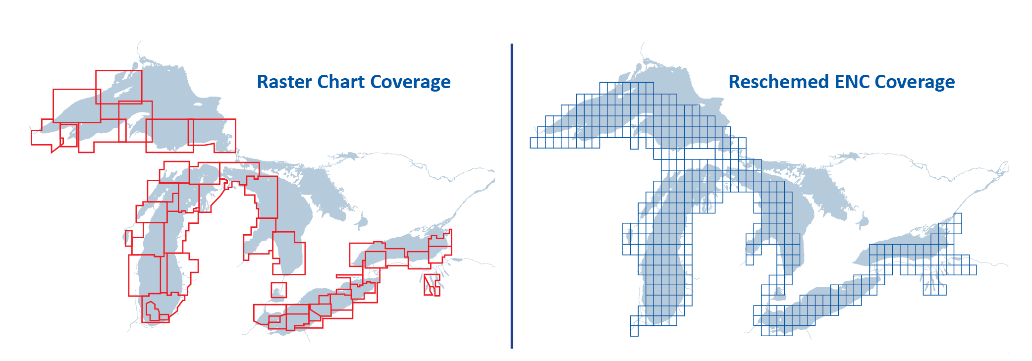
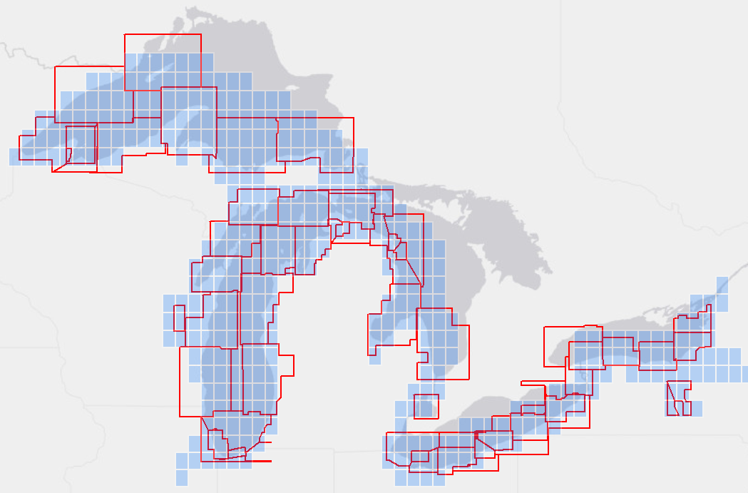
2017 NOAA’s Office of Coast Survey - Marine Chart Division has been engaged in a multi-year project to transform its nautical chart production system from a cell based CAD model to a database driven GIS.
In addition to its goal of elevating Electronic Navigational Charts to the Nation's primary source of data for navigation, the nearly complete system will support a complete product suite re-scheming for improved data consistency, product planning and customer satisfaction.
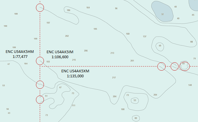
The arrangement or layout of a set of charts is called a scheme – a systematic configuration of chart "footprints".
NOAA is creating a new gridded layout of rectangularly shaped charts for its electronic navigational chart (NOAA ENC) product suite.
In the early 1990s, NOAA began digitizing data from its paper nautical charts to create content for a new digital chart product, the electronic navigational chart.
NOAA ENC catalogue
The scale and limits of each ENC chart (called a cell) were inherited directly from its corresponding paper chart.
The resulting ENC product suite consisted of over 1200 irregularly shaped ENC cells, compiled in over 100 different scales.
Below, the original layout of the "approach scale" ENCs in the Great Lakes is shown in red.
The new gridded scheme for the same coverage is shown in blue.
Comparison of old and reschemed ENC coverage over the Great Lakes
Why NOAA is focusing efforts on improving the ENC?
There is a growing need for ever more detailed nautical charts.
This is driven by several factors, including larger ships now entering ports and transiting channels with the tightest of under keel clearances - requiring more precise depth information, the greater adoption of (in some cases, the requirement for) use of digital charts, electronic navigational systems, and GPS - requiring greater positional accuracy.
Since July 2018, the International Maritime Organization (IMO) has required nearly all commercial ships on international voyages to use an Electronic Chart Display and Information System (ECDIS) and ENCs (as specified in the International Convention for the Safety of Life at Sea (SOLAS), Chapter V, Regulation 19, "Carriage requirements for shipborne navigational systems and equipment"). ECDIS is a sophisticated navigation system that is integrated with other ship equipment and sensors, such as GPS, gyroscopes, and sometimes radar.
In 2016, the U.S. Coast Guard (USCG) published Vessel Inspection Circular No. 01-16 (NVIC 01-16). This announced that commercial ships on domestic voyages within U.S. waters may now use ENCs in lieu of paper nautical charts. Recreational boaters are also making greater use of ENCs and developers of navigation and chart display systems have responded by making ENC compatible equipment available to a broader community of users.
Schedule
Reschemed ENC design
ENC usage bands and standard scales
Paper nautical charts and ENCs are created at various scales for different navigational purposes.
The smallest scale (least detailed) "Overview" charts are used for basic voyage planning.
The largest scale (most detailed) "Harbor" and "Berthing" charts are used for navigating into harbor and maneuvering to a pier or wharf. ENCs are categorized into six usage bands, sometimes called scale bands. The new ENC scheme uses only 11 scales, two each for bands 1 through 5 and one for band 6.
The table below compares the scale ranges of the old ENC scheme to the new standard scales for reschemed ENCs.
New Standard ENC Compilation Scales
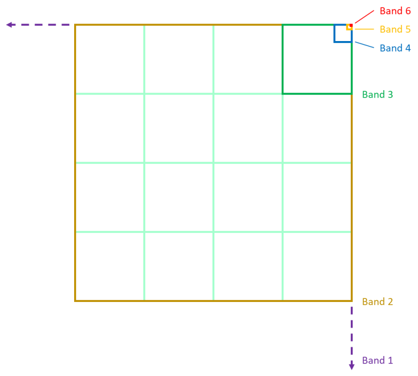
Standard ENC cell shape and size
The new ENC layout consists of nested cells whose boundaries follow lines of longitude and latitude.
Sixteen larger scale ENC cells fit inside one cell of the next smaller scale band.
The figure below shows how 16 band 3 cells (green squares) fit inside one band 2 cell (brown) and the relative sizes of the other bands.
Nesting of reschemed ENC cells
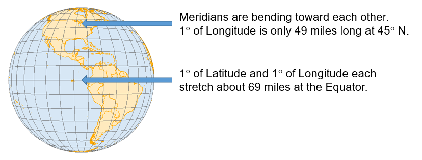
Latitude-based ENC cell width
On the globe, lines of longitude - also called meridians - converge at the Poles.
Thus, the area of the Earth covered by ENC cells defined by equal extents of latitude and longitude will be narrower for ENCs further away from the Equator.
Reschemed ENC cells take this narrowing into account. Cells closer to the poles are widened by increasing their longitudinal extent as a multiple of their height.
Distance between meridians decreases as they converge at the poles
Thus, ENCs are wider longitudinally as they get further from the poles, so the extent of the coverage "on the ground" doesn't get too narrow.
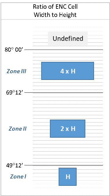
The width of reschemed ENCs is determined by its location within three zones of latitude.
There are three standard widths that apply to bands 3 through 6, detailed below.
The zones for bands 1 and 2 are determined by a different method.
Width of an ENC cell is a multiple of its height (H), depending on the latitude of the cell
The table below shows cell widths, for each zone, for each usage band, in decimal degrees of longitude. Cell dimensions are the same for both of the two standard scales in each usage band.
For example, the height of all band 3 ENC cells is 1.2° in latitude. Band 3 cells below 49° 12' N fall into Zone I and have a cell width equal to their height.
Thus, band 3 cells in Zone I have a width of 1.2° in longitude. Band 3 cells falling between 49° 12' N and 69° 12' N are in Zone II and have a width of twice their height, or 2.4° in longitude.
The width of cells falling in Zone III is four times their height, or 4.8° in longitude.
For band 2 ENCs, all cells with the contiguous 48 states are considered to be in zone I.
Band 2 ENCs west of Washington State in the North Pacific are considered to be in zone II, except for ENCs in Alaska covering Point Hope, the North Slope and the Artic Sea, which are considered Zone III.
Band 1 ENCs will be some of the last cells created as part of the rescheming effort.
The placement of individual band 1 cells within specific width zones has not yet been established.
Enhancements implemented in new ENCs
As new gridded ENCs are created, a number of improvements to the quality and consistency of the data are being implemented.
Larger, standard scale coverage
Many charts and the associated ENCs were compiled at scales that happen to match one of the standard scales used for reschemed ENCs, such as 1:80,000, 1:40,000, 1:20,000, and 1:10,000.
In these cases the new, reschemed cells generally retain the scale used in the old scheme.
If coverage in the original ENC scheme was not compiled at a standard reschemed scale, then the reschemed cells are usually "bumped up" to the next larger scale.
An example of this is the new band 4 coverage in Lake Superior, in which the 1:120,000 scale ENC coverage was replaced by more detailed 1:80,000 cells.
The use of fewer chart scales for reschemed ENCs also facilitates resolving discontinuities and properly "edge-matching" data between adjacent ENC cells.Standardized metric depth contours
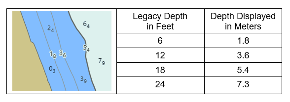
When NOAA digitized paper charts to create the first NOAA ENCs, depth values for soundings, depth curves, and other features with depths were converted from the fathoms and feet shown on the charts to meters to populate the ENC database.
The ENC product specification established by the International Hydrographic Organization requires depths to be stored as metric values.
However, the depth contours continued to reflect the intervals in which they were compiled.
Thus, depth contours of older ENC data displayed in meters will show fractional metric values resulting from the unit conversion from feet to meters, as shown in the image below.
When the ENC rescheming project is completed, all depth contours will be compiled in whole metric units.
However, some newly reschemed ENC cells will not be recompiled in their initial release (first edition) of the cell.
The image below shows examples of whole 2, 5, 10, 20, and 50 meter depth contours.
The depth value of soundings will also be stored and displayed with a higher degree of precision than available on paper charts.
Soundings less than 30 meters deep are stored and displayed as meters with subscripts in tenths of meters (decimeters) - a granularity smaller than 4 inches.
Depiction of metric ENC depth contours
The table below shows the standard depth contour intervals that will be used in reschemed ENCs for each usage band.
These are based on depth intervals specified in the IHO S-101 ENC Product Specification (in the "Depth area" section of the IHO S-101, Electronic Navigational Chart Product Specification, Annex A, Data Classification and Encoding Guide).
Areas that have extremely flat or steep bathymetry may use a modified set of depth contours, especially for bands 5 and 6.
New Standard Metric Depth Contour Intervals
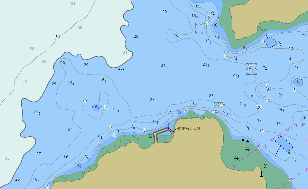
Resolution of discontinuities in adjacent ENCs
The legacy of the original paper charts from which ENC data was digitized lives on in the current suite of ENCs.
Adjacent paper charts, even those having the same navigational purpose (harbor, approach, coastal, etc.) are often compiled at different scales to accommodate different paper orientations and sizes, or a desire to "stretch" coverage to include harbors or other features at either side of a chart.
Different depth contour intervals are often used on different scale charts, and the techniques for "edge matching" adjacent ENC cells of different scales can be challenging.
The figure below highlights discontinuities on three adjacent ENC cells.
Not only do depth contour intervals sometimes change between adjacent cells, depth contours of the same value, compiled separately, and at a different scale, sometimes do not match.
As new ENC cells are created for the gridded layout they will be recompiled with standard depth contour intervals that match across ENC cell boundaries within the same standard scale.
Similar alignment errors among other features, such as shoreline, will also be resolved as new ENC cells are created.
Examples of discontinuities in three adjacent approach usage band 4 ENC cells
ENC rescheming schedule
When compiling data for several different scale charts, best cartographic practices include compiling source data through the scales, beginning with the largest.
This large scale compilation is then generalized for the next smaller scale map or chart and the generalization process is repeated for successively smaller scale coverage.
This technique is applicable to both traditional paper and raster chart compilations as well as for ENCs.
Thus, the general plan for the ENC rescheming schedule is focused on creating band 5 ENCs along the coasts first, followed by the next smaller scale, band 4 cells, then band 3, etc.
There may be exceptions to this general strategy, based on the scale of the existing ENC coverage, the availability of source data, and other factors.
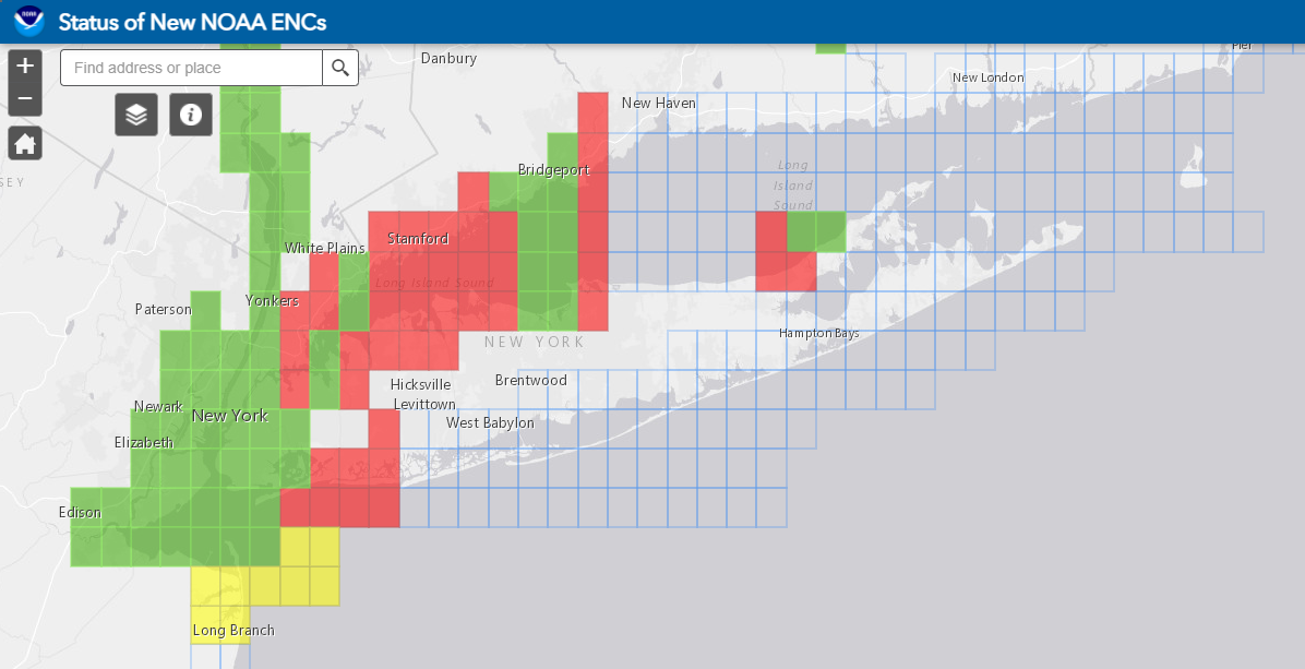
Blue rectangles show planned ENC footprints, red show ENCs in
work, yellow indicates cells in review, and green are completed ENCs
that are available to the public.
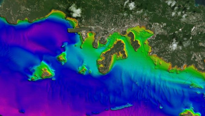
Thomas, US Virgin Islands, mapped using
Lidar and depicted with false-colour (purple is deep, orange is
shallow). Land areas are depicted with satellite imagery. (Source: USGS)
Visualization with the GeoGarage platform (NOAA raster chart)
From Hydro by Italo Oliveira Ferreira, Laura Coelho de Andrade
Since the 1970s, remote sensing has increasingly been used to conduct underwater surveys. Several methodologies are employed in hydrographic surveying, from direct techniques such as probing rods to more sophisticated techniques such as satellite-derived bathymetry and altimetric radar. The growing need for data that is increasingly accurate and available with a quick turnaround has recently led to a worldwide effort to develop sensors and alternative techniques for measuring depth.
Bathymetric survey platforms include surface vessels, submersible platforms, aircraft and satellites (see Figure 1). Vessels range from large ships, used in offshore surveys, to uncrewed vessels, either remotely controlled or autonomous. The most commonly used submersible platforms are autonomous underwater vehicles (AUVs) and remotely operated vehicles (ROVs), both of which are used for high-resolution mapping in deep water and can be controlled from a surface vessel. Acoustic sensors are preferred on these platforms, although AUVs and ROVs now also carry light detection and ranging (Lidar) systems and high-resolution photographic cameras.
Figure 1: Platforms used in hydrographic surveys: (a) NOAA Ship Fairweather for offshore surveys, (b) EchoBoat-ASV from Seafloor Systems, (c) Hugin AUV from Kongsberg.
The Ship Fairweather of the National Oceanic and Atmospheric Administration (NOAA) is mainly used in offshore hydrographic surveys and port surveys and is equipped with a Reson Seabat 8160 echosounder, which surveys depths of up to three kilometres. EchoBoat is a small autonomous surface vehicle (ASV) used in bathymetric surveys of inland waters and sheltered areas that are performed using acoustic sensors. The Hugin AUV from Kongsberg has, in addition to the EM2040 multibeam echosounder, a laser profiler, a coupled photographic camera and a HISAS 1032 synthetic aperture sonar, among other systems and sensors.
Crewed and uncrewed aircraft are also used in bathymetric mapping. These platforms are equipped with passive sensors, which allow depth estimates to be made through the spectral response of the submerged bottom, and active sensors, such as bathymetric Lidar. Similarly, satellites also function as bathymetric survey platforms, either through the use of orbital images (bathymetry by spectral response) or through the use of altimetric radars (active sensors), as in the Seabed 2030 project. There are also hybrid solutions that enable the acquisition of bathymetry using an echosounder towed by a low-flying unmanned aerial vehicle (UAV; Figure 2) or an integrated ground penetrating radar (GPR). Unmanned surface vehicle (USV)-based platforms are also increasingly used.
Bathymetric Survey Methods
Modern bathymetric surveys are carried out in various media, depending on the method used. Sound waves are used in the aquatic environment, visible light is used in the air and in the aquatic environment, and bathymetry derived from information from altimetric radars is used in the air.
Acoustic systems are used both in shallow water of around one metre deep and in deep water of many kilometres of depth. Such systems are preferred as they provide more accurate data than other methods. The high attenuation of visible light in the aquatic environment means that depth measurement by optical remote sensing (active and passive) is limited to shallow depths. While aerophotogrammetric (short distance) and orbital images are employed for bathymetry at depths of up to ten metres, Lidar systems operating in the green wavelength can reach up to 50 metres in clear waters. Finally, altimetric radars can be used to obtain depths in deep waters, especially where bathymetric information is scarce or non-existent.
Acoustic Sensors
The first record of the use of an echosounder, or sonar as it is popularly called, is when Leonardo da Vinci placed a tube in water to detect big ships, by positioning his ear in the tube. There are both passive and active sonar systems, but active sonar is used in depth measurement.
Between 1920 and 1930, the world saw the development and implementation of single beam echosounders (SBESs), which use sound to measure the depth directly below the sounding platform. By running a series of lines at a specified spacing, SBES greatly increased the speed of the survey process, allowing more data to be collected compared to direct methods. However, this method still left gaps in quantitative depth information between the survey lines. Between the 1950s and the 1980s, technological developments resulted in the emergence of sidescan sonars (SSSs) and multibeam echosounder (MBES) systems (beam-formers). Lateral scanning sonar technology offered a qualitative means of obtaining the sonic equivalent of an aerial photograph and improved the ability to identify submerged shipwrecks and obstructions. This proved to be an excellent aid for SBES surveys, since it enabled the search for submerged objects between the navigated lines. Beam-forming MBES made it possible to obtain quantitative depth information for almost 100% of the submerged bottom.
SBES is ideal for shallow water surveys and is very cost-effective. The planning, operation, processing and analysis are simple, and there is a huge range of equipment operating at low frequencies (12kHz–50kHz), high frequencies (100kHz–700kHz) and even dual frequencies (24kHz/200kHz, 33kHz/200kHz, 50kHz/200kHz, etc.).
Figure 2: Integrated system for bathymetry using an echosounder in a UAV.
MBES traditionally obtains depth measurements through the process of electronic beam-forming (Demoustier, 1996). Alternatively, some equipment employs interferometry to measure depth. Such systems are popularly known as interferometric sonar, interferometric multibeam, interferometric sidescan, bathymetric sidescan or phase-differencing bathymetric sonar (PDBS). The latter term is theoretically the most correct, since only the first systems actually employed the process of interferometry.
There are several advantages to using PDBS, the main one being the background coverage, which in some cases is up to 12 times the nadir depth. This means that, at 4m depth, PDBS should be able to cover a range close to 50m, while a standard multibeam (120° swath) would cover about 12–16 metres at this depth. PDBS technology has in fact existed for many decades, but several operational and technical problems were only recently solved. It can be concluded that the main advantage of this type of system is the wider sweeps, which result in a significant increase in productivity in shallow water. A problem still to be resolved is the theoretical uncertainty model (a priori) of the PDBS.
Improvements in synthetic aperture sonar have also take place in the last few years. Kongsberg recently launched HISAS 1032, a system capable of generating approximately 1,000 metres swath at 2.5 knots and images with a resolution of 5cm. For bathymetry, HISAS 1032 demonstrated a significant improvement over its previous version in which a resolution of 50cm was obtained, now producing a resolution of 20cm. The system is able to generate coverage of approximately 4.5 km2/h, which is also high compared to previous versions.
Finally, in all cases, the primary disadvantage of surveys with acoustic systems lies in the high costs associated with vessels and their crew. In shallow waters, a higher level of detail is always required, which is reflected in a higher number of survey lines. In deep water, on the other hand, the problem is the high costs due to the large ships and their crew. Even when using autonomous vehicles, vessels are needed to control the uncrewed platform and provide acoustic positioning when using AUVs.
Air- and Spaceborne Remote Sensing
Despite the high attenuation suffered by electromagnetic waves in water, the visible portion of the spectrum can be employed in bathymetric mapping, especially where acoustic methods have limitations. In this context, depths can be measured either employing passive methods, which measure only the natural light reflected from the submerged bottom (spectral response bathymetry), or active methods, which use lasers to measure the distance to the seabed. The great advantage of these methods lies in the productivity that can be achieved (Figure 3).
Figure 3: Different methodologies for extraction of bathymetry, exemplifying the high productivity of optical remote sensing.
Spectral Response Bathymetry
The method using sensors embedded in crewed or uncrewed aircrafts or satellites is based on the principle that part of the sunlight that reaches the submerged bottom is reflected and can be detected by these sensors, which use this radiation to measure depth and obtain bathymetric maps.
The principle of using orbital and aerial images for bathymetric mapping is not the same as that adopted by active sensors. Satellite-derived bathymetry is based on three techniques: empirical approaches, empirically tuned physics-based approaches and optimization-tuned physics inversion approaches.
Empirically tuned physics-based approaches follow the principle that the intensity of the radiant energy that is reflected by a water column and received by the sensor is a function of the water depth; that is, the portion of solar radiation that penetrated the water column. In most cases, the Normalized Difference Water Index (NDWI) is used.
The empirical approaches are the newest method (machine learning techniques) and not widely used. In the optimization-tuned physics inversion approaches, the application of the model requires the specification of a range of optical properties of the water and the seafloor, but no in situ data is needed for calibration.
Spectral response bathymetry makes it possible to quickly collect data over large areas at a low cost, but the maximum depth is approximately 30 metres in clear waters and much less in turbid waters. In addition, the information is obtained at accuracies that are incompatible with current requirements, restricting its use for planning, recognition and environmental modelling purposes. Aerophotogrammetric and orbital images are therefore mainly used as a recognition and planning tool in areas where bathymetric information is non-existent or insufficient. However, images from orbital and airborne sensors are very useful for the delineation of coastlines and the mapping of port structures and as a navigation aid.
Lidar
Bathymetric Lidar is the most productive method for bathymetric mapping in shallow water (< 50m), as it usually surveys at 180 knots and the covered range is higher than most modern MBES and PDBS. Similar to acoustic systems, Lidar measures depth indirectly using the travel time of a laser pulse. These systems were first introduced in the mid-1960s, originally as a tool for topographic mapping. During flights over lakes and coastal regions, the researchers noticed a double return, from which they concluded that the laser penetrated the water and could be used to map the bathymetry.
Bathymetric Lidar is one of the solutions to address governments' coastal, riverine and shallow-water geospatial and hydrographic needs.
The basic working principle is the emission of two laser pulses, the first in the infrared wavelength (~1064nm), which allows the detection of the surface since penetration into the water is effectively zero, and the second in the green-blue wavelength (~532nm), which – despite a high level of dispersion – can reach the submerged bottom. As with an echosounder, a time series of light intensity (instead of acoustic intensity) is recorded. The typical scan interval is 1ns (10-9 seconds), as opposed to ~1ms to 10µs (10-3 to 10-5 seconds) for acoustic signals. The echo envelope, or waveform, is then used to estimate the depth.
The penetration is generally three times the depth observed with the Secchi disc and is determined in situ. Another method, which is technically more effective, would be to determine the attenuation coefficient for the wavelength used, which describes the exponential decay of light with depth. More modern systems are able to obtain a vertical and horizontal accuracy of about 20cm, with a spacing of 1m.
Altimetric Radar
In the 1970s, the main purpose of radar altimetry was to measure the ocean’s surface that most closely approximates to the geoid. Thus, over the years, several altimetric missions were carried out to meet demands in the areas of geodesy, oceanography and continental hydrology. Examples of this were the Geosat missions in 1985 and ERS-1 in 1991, which obtained as results good-quality surface models of ocean topography. It is known that there are small depressions on the surface of the ocean that mimic the topography below water. This is due to the extra gravitational pull of seabed features such as seamounts, producing variations in gravity which in turn produce small variations in the height of the ocean surface. These depressions can be mapped by an altimetric radar mounted on a satellite. In deep ocean basins, where sediments are thin and the morphology simple, altimetric radar data can even be used to predict current bathymetry.
On continental platforms (where sediments are thicker and conventional bathymetric surveys are in abundance), the gravimetric methodologies used to estimate depth are of limited value. However, much bathymetric data has been obtained together with gravimetric information derived from satellites, allowing an optimal interpolation of the depths.
It is therefore evident that information derived from altimetric radars is not sufficiently accurate for verifying risks to navigation and also not functional in shallow water, where other techniques (such as Lidar) produce more reliable and better results. In addition, the data obtained with radar alone is unable to provide the true depth and correlation with bathymetric data is necessary, as is performed in the methodology for measuring bathymetry through the spectral response.
Conclusions
Our knowledge of bathymetry has advanced rapidly over the last century, due to the rise of acoustics, optics and radar techniques.
Methodologies have been developed that are capable of providing a better quality control of the information acquired, together with the use of more robust and rigorous interpolators that have led to forms of representation of the seafloor in a more realistic way.
Despite such progress, there are still numerous technologies that can be studied and some issues to be resolved.
Further improvements should include motion sensors, positioning systems and speed sensors, lifting platforms and sophisticated software, including algorithms that dynamically compensate and allow narrower beam widths at short distances; in other words, with a higher spatial resolution.
Another trend is the use of point density with robust techniques for cleaning spurious data, as well as more accurate tide models and methods based on unsupervised machine learning.
Deep learning can also be used to predict and classify the seafloor with orbital images with more accuracy and speed and no reliance on in situ data, which will contribute to related areas, such as biological, climatological and sedimentological studies.
Sketch of the coast of the Gulf of Mexico, from Cape Santa Elena to the Pánuco River), attributed to Spanish Royal Cosmographer, Alonso de Santa Cruz, 1544, [AGI, MP-Mexico, 1].
Credit: Source: Archivo General de Indias, Sevilla.
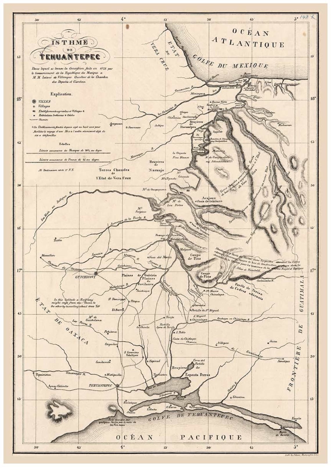
The Isthmus of Tehuantepec, a region located in the south of Mexico, is the shortest distance between the Atlantic and Pacific oceans in all the country.
Only 220 kilometers separate the two oceans.
Current nautical raster chart from SEMAR in the GeoGarage platform
In the first half of the 16th century, Spanish conquerors put great effort into finding a strait that would connect the two oceans.
This meant that, in the conquest explorations of the 16th century, this region was used as an inter-oceanic passage, making approximately two thirds of the journey along the mighty river Coatzacoalcos and the rest overland.
Manuscript map in ink covering the Tehuantepec Isthmus. (1800-1899)
Interest of the Spanish monarchy in the Isthmus of Tehuantepec
In 1580, the mayor of Coatzacoalcos received a mandate from the Spanish crown to discover different aspects of the overseas territories, such as the geography, topography, place names, indigenous languages, plants, etc.
He therefore commissioned a map to describe the geography of the region, indicating the geographic features, towns, and communication routes.
For this, he had the assistance of Francisco Gali, a Spanish sailor traveling across these lands on his way to the Pacific coast.
The exploration of this region between the "North Sea" and the "South Sea" had been, since the conquest of Mesoamerica, fixed in the minds of the Spanish monarchy and their representatives.
Charles V made this project one of the priority missions of the explorers whose objective was to connect the kingdom of New Spain with the kingdom of Peru.
Hernán Cortés also used it in 1520 to transport equipment, stores, and supplies.
1828
Analysis of the map
An analysis of the map suggests that it was made in haste.
Both the errors in distances and the numerous corrections which can still be observed support this conjecture.
It seems that Francisco Gali was more interested, from his point of view as an explorer and navigator, in the most important aspect of the region: the possibility of connecting the North Sea and the South Sea through the Strait of Tehuantepec.
Francisco Gali: Navigator, explorer, cosmographer and cartographer
Francisco Gali, born in Seville in 1539, is a singular enigmatic character.
Barely any information exists about him prior to his appearance in America.
n spite of the few maps discovered that were drawn by Gali (two signed and a third attributed to him), the historic documents refer to him not only as an expert mariner, but also as a skilled cartographer and cosmographer.
Life in Arviat, Nunavut, on the western shores of Hudson Bay, revolves around resources provided by the tundra and surrounding waters, but the landscape is rapidly transforming.
For generations, hunting, and the deep connection to the land it creates, has been a mainstay of Inuit culture. As the coastline changes rapidly—reshaping the marine landscape and jeopardizing the hunt—Inuit youth are charting ways to preserve the hunt, and their identity.
Perched like a figurehead on the bow of the boat, the girl hoists the harpoon. She scans the waves for a streak of white, a plume of red, guiding her to her target below. Around her, a chorus of outboard motors screams into the brisk breeze. Flocks of gulls keep raucous watch from above, while polar bears patrol silently on distant shoals. All are after the same quarry—a pod of beluga whales swimming along the coast of Hudson Bay in Nunavut, part of the Inuit homeland in northernmost Canada.
“There, over there,” come excited yells, arms waving toward a circle of roiling water about 20 meters ahead. A young beluga, wounded by gunshot, is thrashing. A fin stabs the surface. Then a patch of belly flashes toward the sky. Now it’s up to Rolanda Uquuyuq Tiktaq, a young Inuk out on her first hunt, to plant the harpoon and claim her first kill.
Tall and slender, the middle schooler from Arviat—a 2,900-some, predominantly Inuit hamlet on Hudson Bay’s west shore—may not fit your classic hunter stereotype. She rocks a diva headwrap, glam rhinestone sunglasses, and a stylish maroon parka. Her favorite subject in school is math. She wants to be a cosmetologist when she grows up. But she also wants to learn the life skills of her ancestors and gain the environmental wisdom passed from generation to generation of Inuit hunters.
As Rolanda, a native Inuktitut speaker, puts it in her shy English: “I want to learn about the land.”
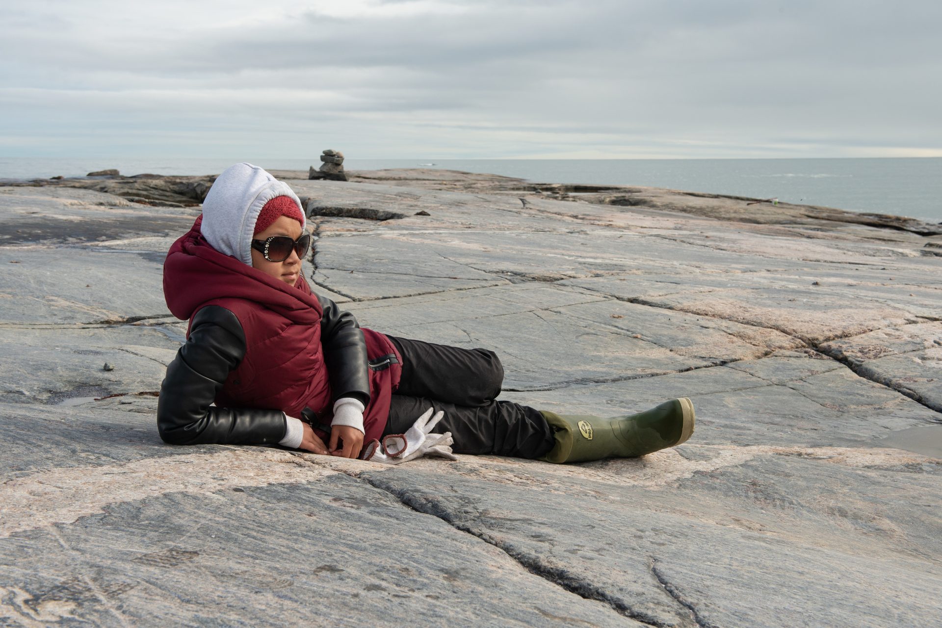
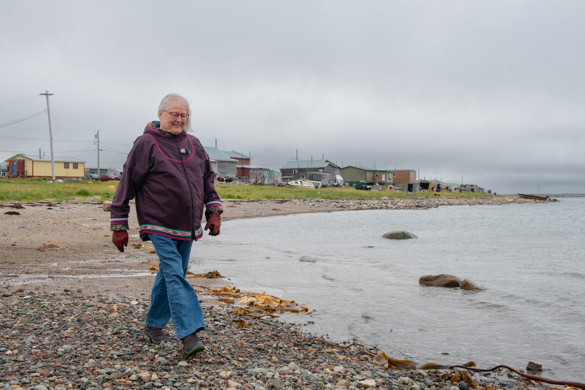
Rolanda Uquuyuq Tiktaq, a participant in the Aqqiumavvik Society’s Ujjiqsuiniq Young Hunters program relaxes on a rocky islet in Hudson Bay, while her group waits for belugas.
It’s a chilly, gray evening on this vast inland sea some 600 kilometers south of the Arctic Circle in August 2021. We’re here with the Ujjiqsuiniq Young Hunters, an Arviat program schooling youngsters in Inuit Qaujimajatuqangit, or IQ—the systematic “way of knowing” that has guided life here for millennia. Aimed at propagating the culture’s deep roots in the landscape, passing along time-honored practices in monitoring—ujjiqsuiniq is a process of keen observation—and sustaining their ancestral hunting grounds, the program is preparing today’s youth to become the Inuit land stewards of the future.
“Being respectful of the environment … living with the land in mind … these traditional principles and how strongly they were followed are things we try to pass on to youth today,” says Shirley Tagalik, board chair of the nonprofit community wellness group Aqqiumavvik Society, the parent organization of the Young Hunters program. The nomadic peoples who inhabited this coastal tundra for some 5,000 years relied on the land and sea for all their resources. “So, of course they had to be not just respectful,” Tagalik says, “but they had to be good stewards, good conservers of those resources.”
The Young Hunters are part of a growing global recognition of Indigenous environmental knowledge and stewardship. The project is supported by the Canadian government’s Indigenous Guardians Pilot Program, a recent initiative promoting Indigenous leadership in preserving their ancestral lands and resources.
For Inuit, that’s the traditional responsibility of hunters. Life here depended on hunters knowing the ways of animals such as caribou, whales, and seals. Elders taught new hunters how to safeguard the ecosystem and harvest sustainably so the animals would be there for the next generation. Even after the Canadian relocation programs of the mid-1900s forced Inuit to leave their seasonal camps and settle permanently in often-distant places, hunting remains central to their descendants’ identity and way of life. And “country food,” such as maktaaq—raw whale skin and blubber—is an important staple in a place where other options are limited and expensive.
The primary grocery outlet in Arviat, Nunavut, is one of the busiest spots in the hamlet. Canada’s northern communities, including Arviat, pay notoriously high prices for groceries flown or shipped in from the south. Many locals still rely heavily on foods they hunt and harvest from the land or water.
Luke Suluk shows us ancient qajaq rests and tells us the history of the land outside Arviat, Nunavut.
But the world around Hudson Bay Inuit is rapidly transforming. Straddling the Arctic Circle, the region is in one of the fastest-warming places on the planet. Hunters today face conditions their ancestors never could have imagined, including thinning sea ice, disrupted seasons, and disturbed animal behaviors. What’s more, due to a geological phenomenon known as glacial isostatic adjustment, the land here is rising as it rebounds from the crush of ice sheets that vanished thousands of years ago. Paradoxically, this means that while most of the world’s coasts in our warming climate face an encroaching ocean, the sea level here is actually plunging. Shoals and reefs, once deep underwater, are emerging as new, unmarked hazards for boaters on the shallowing bay. To maintain access to crucial community resources, the Young Hunters have followed the IQ principle of qanuqtururangniq—finding innovative and resourceful solutions—and are using pioneering technology to survey the bay’s largely uncharted floor. The nautical data will be shared with government hydrographers and made available to the public. Photographer Shanna Baker and I have come here to see how these young Indigenous scientists are deploying next-generation tools with past generations’ guidance to help make navigating this changing seascape safer for everyone.
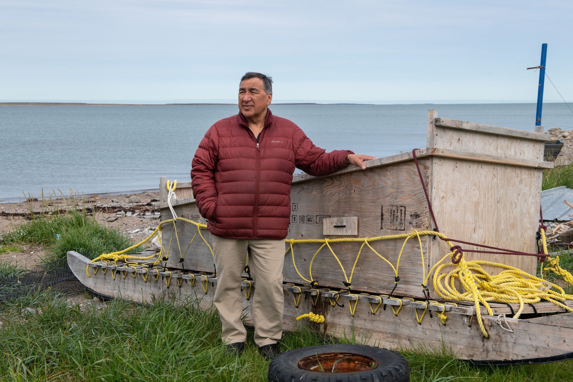
The skeleton of Qulaittuq, a York boat that served the Hudson’s Bay Company outpost at what was once called Eskimo Point, lies along the coastline just beyond Arviat. As the esker beneath it has risen over time, the ship, beached in the 1920s, has shifted farther and farther from the water’s edge.
When we arrive in Arviat, though, we find all other activities have been preempted by whales. The annual beluga migration from their summer breeding grounds near Churchill, Manitoba, north to their winter territory in Hudson Strait was at least two weeks overdue this year. Then, this morning, came the news. A pod of these small, torpedo-shaped cetaceans—around the length of a Mini Cooper, but packing a dense, nutritious layer of blubber—has finally been seen heading this way. Along with three boys and two girls from this summer’s group of Young Hunters, plus instructors, drivers, and helpers, we hop into a trio of motorboats and spend the day racing around Hudson Bay.
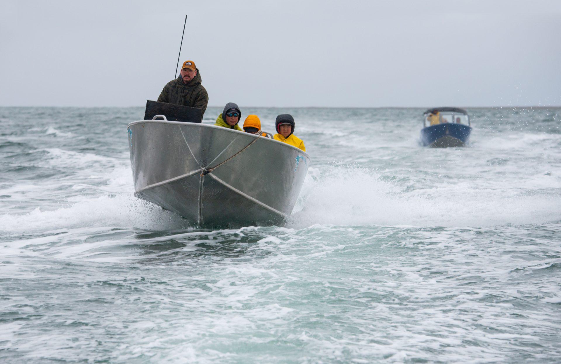
Leaders and participants in the Young Hunters program zip around Hudson Bay in pursuit of belugas.
We’re not alone—it seems like all of Arviat is out chasing the pod. All day the CB radio on our boat growls with a mix of Inuktitut and English, reporting sightings that have so far fizzled out. But late in the afternoon, the radio chatter suddenly reaches a new, frantic pitch. Whales to the south, come the excited reports. This time for sure!
We take off, zigzagging full tilt through an obstacle course of nearly invisible obstacles. It’s a heart-pounding demonstration of the rising land below.
“There’s a bunch of low areas that weren’t here a couple years back,” Aupaa Irkok, a Young Hunters instructor, tells me, pointing toward a stretch of rocky fingers riffling the waterline off starboard. Irkok peers out from under a black cap pulled down to eyebrow level, emblazoned with a pair of the traditional sealskin boots known as kamiit. Those are just the visible hazards, I’m reminded. As the land pushes upward, a battery of moraines, scarps, and other features on the seabed beneath us is pushing ever closer to the surface.
“The world is moving itself, like redrawing,” Irkok observes in English inflected by the rolling cadence of Inuktitut, concluding with “Ii” (local dialect for “yes”). The kamiit bob as she nods.
It’s evening, but the northern sun is still high when we finally reach the whales. Several boats are already carving circles around the pod. Shots crack across the water. Smoke and the sulfur smell of gunpowder lace the evening air.
Speedboats and rifles have replaced kayaks and spears. But planting the traditional unaaq (harpoon) still marks an Inuit hunter’s first qinalugaq (beluga catch). That’s a major milestone in a young Inuk’s life. A bridge between future and past.
Rolanda is nervous as she waits for the chance to strike. She feels proud and excited and a bit shaky. The long, wooden shaft with a sharp metal tip is heavy and hard to handle as she points it left, then right, trained on the darting whale. With Irkok’s coaching, she watches for the creature to surface, take a breath. Then she will hurl the harpoon.
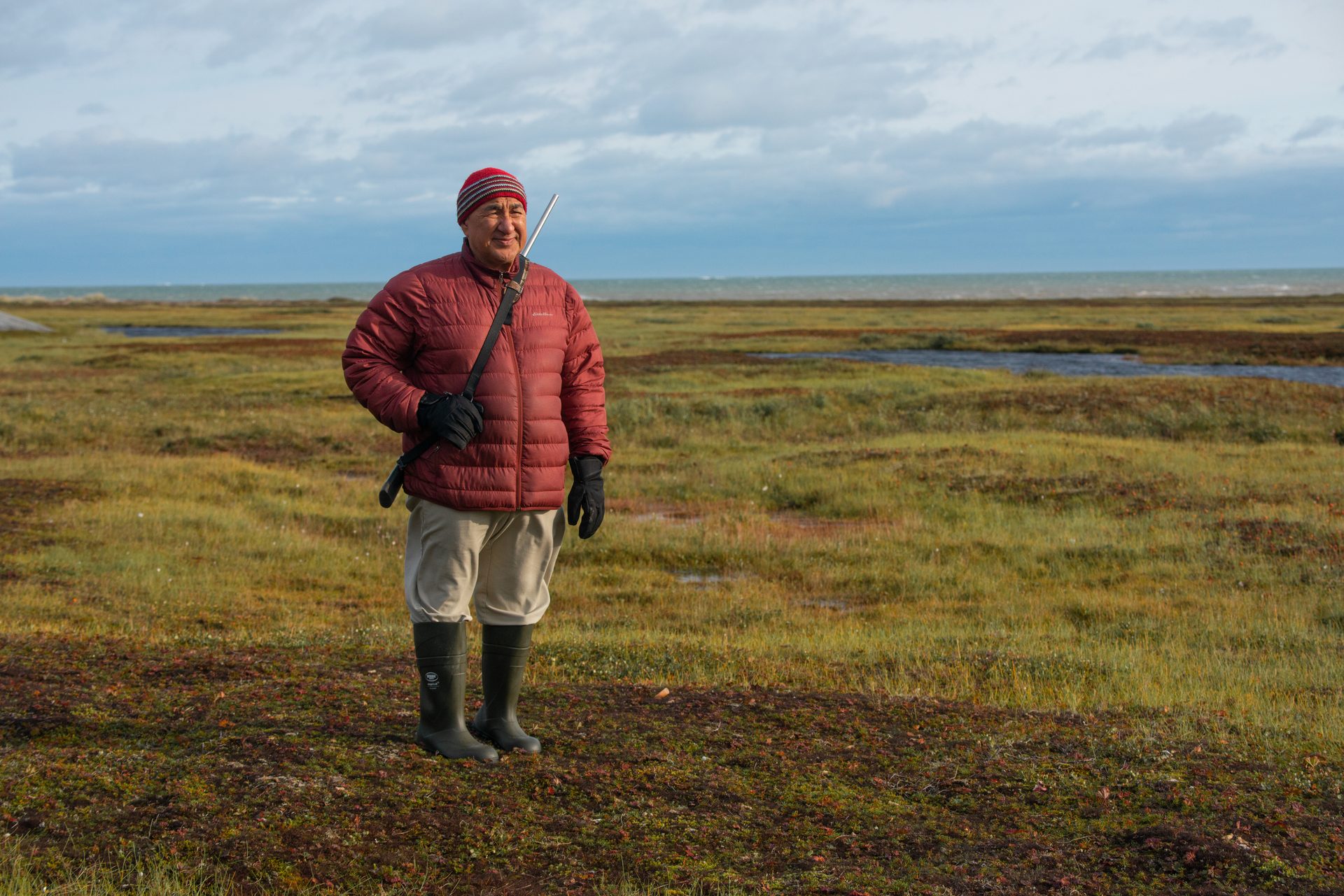
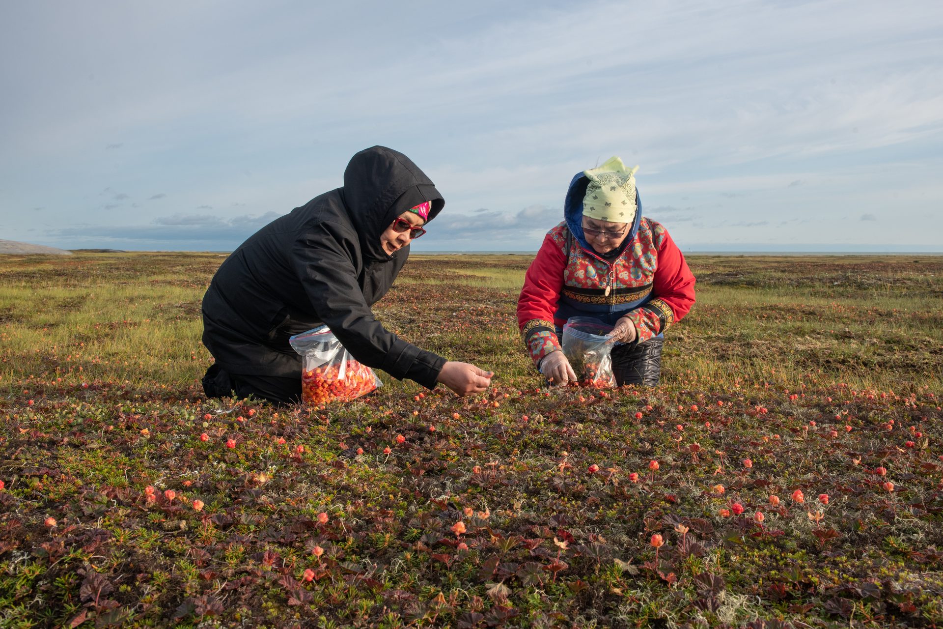
Stacked stone inuksuit stand sentinel over the tundra, where Joe Karetak patrols with a rifle as his wife and sister-in-law pick cloudberries on a blustery afternoon a few days later. Crouch-crawling along the marshy ground, gathering the small, salmon-colored fruit they call aqpiq for jams and pies, the women are in no position to watch out for polar bears.
Joe Karetak keeps watch for polar bears as Debbie Baker
and Susan Karetak gather cloudberries on the tundra near Arviat.
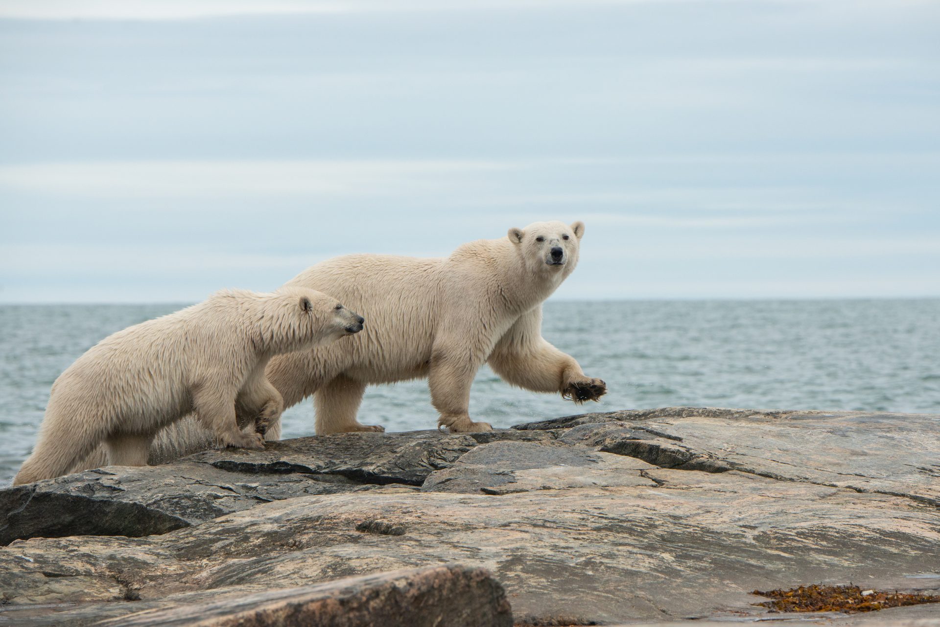
Arviat, on the western Hudson Bay migration route known as Polar Bear Alley, is a favorite haunt for bears waiting for the winter sea ice to return. The bay here generally used to freeze solid enough for bears to hunt seals, their dietary mainstay, by November. These days, freeze-up often doesn’t come until December. That means these massive marine mammals are hungrier and on land for longer—to the detriment of both ursine and human populations. It’s one of the ways the disturbed climate is upsetting the precarious balance of life in these northern lands. Says Karetak, a burly hunter with a philosophical air, “some of the seasons in the year are changing time.”
Polar bears are often spotted around Arviat, searching for the same sustenance as the human hunters.
Karetak, who teaches traditional Inuit knowledge for the Aqqiumavvik Society, has seen a lot of changes around Arviat since he was born here in a blizzard six decades ago. The hamlet’s name, for instance. It was called Eskimo Point when he was a child, a handle bestowed by foreign whalers in a past era. In 1989, residents voted to change it to a name based on arviq, Inuktitut for bowhead whale. Ten years later, Arviat, along with a vast swath of land stretching from the Manitoba border to the Arctic Ocean, changed from being part of the Northwest Territories to being in the new Inuit territory of Nunavut: Inuktitut for Our Land. It was the first of what are now four regions in northern Canada that make up the Inuit homeland called Inuit Nunangat.
Karetak recounts an experience he had getting stranded on an ice sheet with his son while hunting—which ended up with him rescuing his rescuer—and how mindset can make a difference between life and death out on the land. As a specialist in Qaujimajatuqangit, the Inuit traditional knowledge system, Karetak shares lessons needed for survival with members of the Young Hunters program, and others.
But as the people regain control of their ancestral homeland, powerful forces are reshaping the environment. Due largely to the greenhouse gas emissions of societies far to the south, Hudson Bay air temperatures have climbed more than 2 °C since the late 1980s. Waters have warmed nearly as much in some parts. Permafrost is thawing. Sea ice—crucial for winter hunting and travel and a vital habitat for marine life—is not only forming later, it’s breaking up earlier, and becoming perilously thin. And as emissions continue essentially unabated, a recently released Climate Atlas of Canada projects that during the next 30 years, Arviat will be nearly 3 °C warmer on average than it was around the turn of the century.
The off-kilter climate is hobbling the country food harvest. Weather has turned unpredictable, putting hunters out on the land and water at risk of sudden, life-threatening storms. Animal habitats and behaviors are changing, undermining generations-long knowledge of when and where to hunt. The tundra is greening, with normally calf-high Arctic willows shooting up to shrub height in places, impeding travel. And previously rare foreign invaders such as killer whales are moving in.
On top of this “new” and dramatic climate upheaval, environmental change set in motion nearly 20,000 years ago—the wane of the last ice age—is dealing a double whammy to the Hudson Bay Inuit way of life. As the climate warmed toward the end of the late Pleistocene, the Laurentide Ice Sheet that had buried the region more than three kilometers deep began to melt. By the dawn of the Holocene some 8,000 years later, the Earth’s crust, liberated from the icy weight that had pushed it down several hundred meters here, had started to spring back. Glacial isostatic adjustment, also known as postglacial rebound, has been rearranging the landscape ever since.
As depicted here, the Laurentide Ice Sheet has retreated dramatically over centuries. Released from the ice’s weight, the land around Hudson Bay is rising.
While land is readjusting across the previously glacier-covered north, the Hudson Bay region, former home to some of the planet’s thickest and most-persistent ice, is experiencing some of the greatest uplift, says Karen Simon, a geoscientist at the Delft University of Technology, Netherlands, who has studied the rebound around Arviat. The west bay was near the ice sheet’s bullseye. According to Erik Ivins, a researcher at NASA’s Jet Propulsion Laboratory, GPS observations and models indicate a current rise rate of 10 to 15 millimeters a year.
That’s more than double the rate of most other rebounding parts of the north. And in today’s warming climate, the accelerating loss of the planet’s remaining ice is boosting the uplift by as much as another millimeter per year. What’s more, the crust and mantle below are slowly creeping sideways as the balance of weight on the Earth’s surface moves from land to sea.
Arviat long-timers are well aware of the shifting topography.
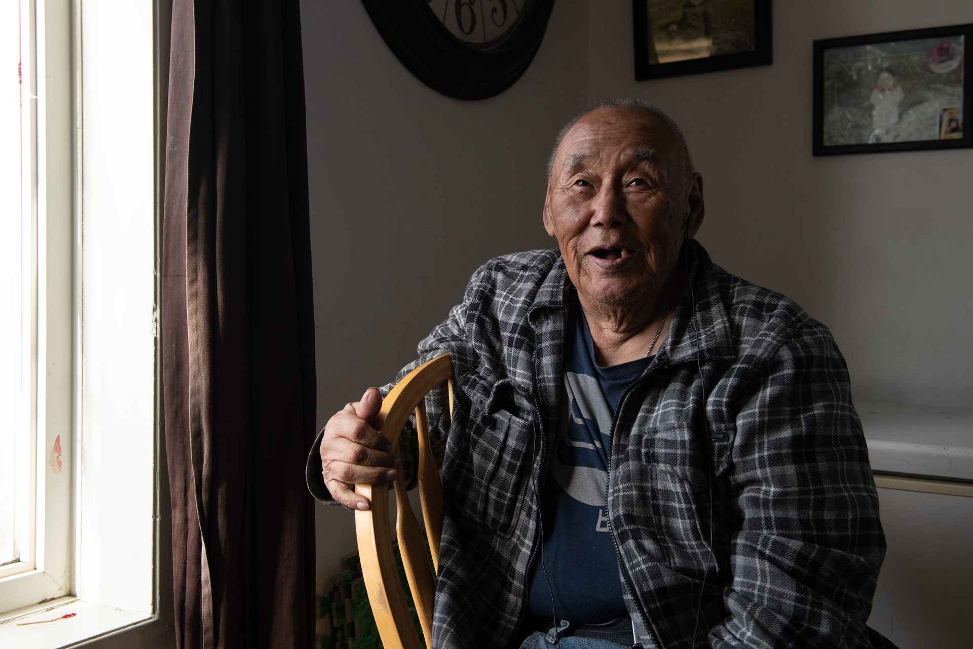
Elder Louis Angalik has watched the landscape around him shift over his 80-some years. The sea is getting shallower, he says.
The earth beneath Nunavut has moved, Elder Louis Angalik tells me through a translator. Seated at his breakfast table in his cozy house in Arviat, the octogenarian tents his hands to show how the terrain has pitched since the days when he and his family spent most of the year out on the land. He speaks of following the caribou herds, hunting seals, trapping foxes, and selling the pelts to the Hudson’s Bay Company trading post that used to stand nearby.
“The sky is different now,” Angalik says. “The sun is higher. The sea is getting shallower.”
Indeed, while the global ocean is rising an average 3.6 millimeters a year due to expanding water and melting land ice, up here, that ocean rise is outpaced by land rise—resulting in a sea level plunge. The height of the bay at nearby Churchill, Manitoba, dropped nearly three-quarters of a meter over the past 80 years, long-term measurements by the US National Oceanic and Atmospheric Administration show.
For Hudson Bay, that adds up to a serious scoop out of this already-shallow body of water. Although it’s the second-largest bay in the world—surpassed only by the Bay of Bengal—thousands of years of incremental rebound have left it unusually shallow for a bay of this size. And the sea level along Hudson Bay’s west coast could drop some three-quarters of a meter farther by century’s end.
The stretch marks on the distending land are visible from the sky. Ridges of shoreline extend like tree rings along Nunavut’s coast, marking the beaches’ growth. The flight path to Arviat’s tiny airport crosses what used to be an island—Qikiqtaarjuk—with a historic site linked to the legendary Inuit voyager Kivioq. Today it’s a peninsula, tightly stitched to land.
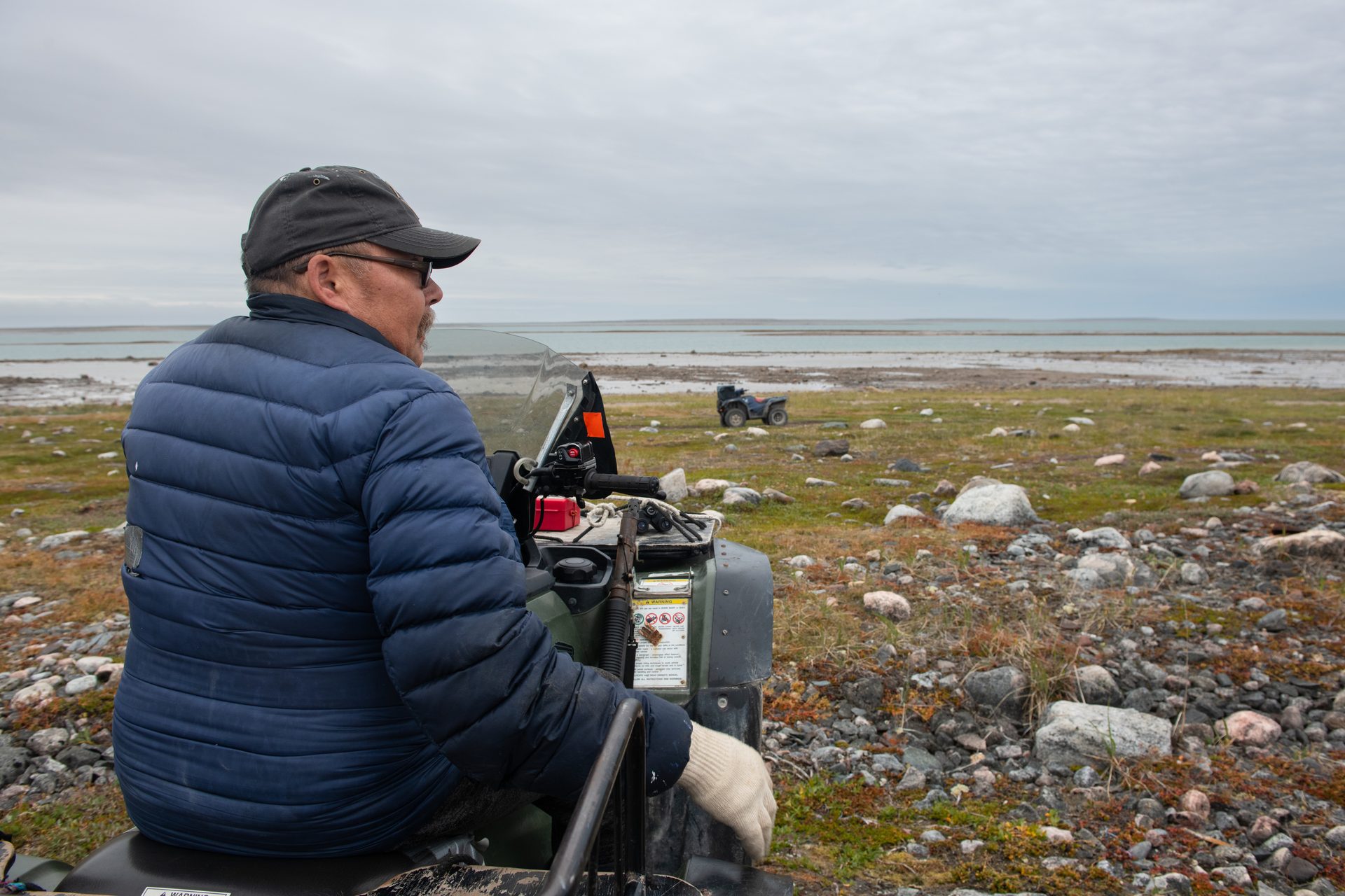
“The landscape is growing,” says Leo Ikakhik, astride his ATV on the spit of land east of town where the original settlement sprang up around a Hudson’s Bay Company trading post built in the 1920s. Nothing remains today but some rock outlines of long-gone buildings and the beached skeleton of a York boat that once served the post. Now it’s a hangout for polar bears, and Ikakhik is one of Arviat’s official polar bear patrollers. From August to freeze-up, he rides up and down the shoreline, armed with binoculars and a rifle, calling the town hotline when he spots bears coming in from the bay. He has just given me a stern warning for wandering too close to the water for his liking. Then he settles back in his seat, squints into the biting wind, and points toward the bay.
As one of the community’s official polar bear patrollers, Leo Ikakhik watches for bears that regularly traverse the region around Arviat, on a route known as Polar Bear Alley. Like other locals, he has observed significant changes to the landscape.
“All of this you see here is the land rising,” Ikakhik tells me. We gaze at the rocky flats stretching half a kilometer out from shore and smell the seaweed rotting in shallow pools where once there was navigable water. “None of this used to be here,” he says.
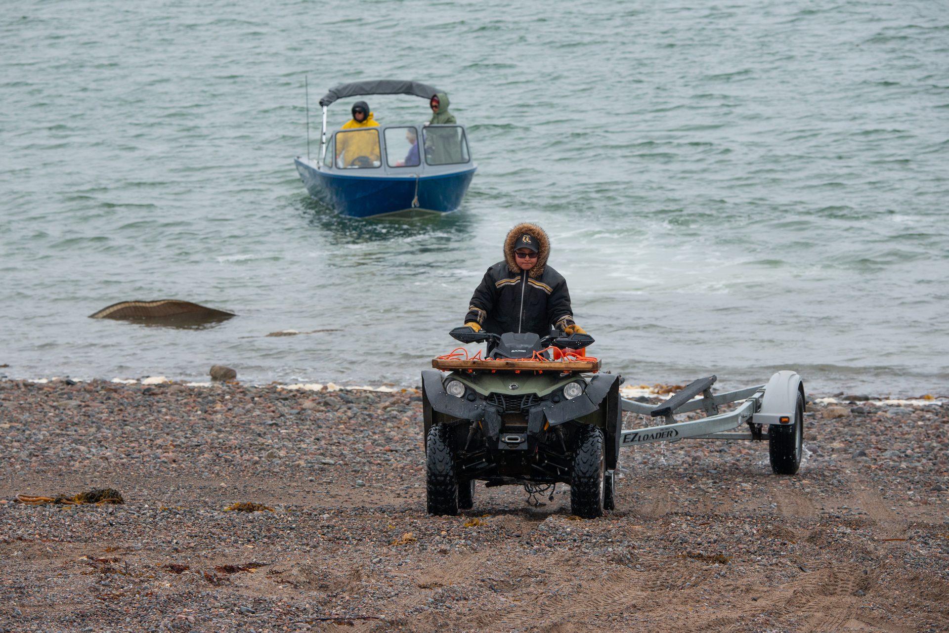
That spells trouble for Arviat, where life revolves around the bay. Boats clutter the rocky shoreline, clatter on trailers towed by ATVs over the town’s unpaved streets, clang on the water at all hours as hunters and fishers ply the long northern summer days.
Aupaa Irkok, an instructor with the Young Hunters program, pulls a boat trailer out of the water at the stretch of rocky shoreline the community uses as its launch site. Power boats and ATVs are two of the main modes of transportation in Arviat.
Lately, those boats have been running into shoals that never posed a problem before.
Karetak, who has navigated these waters for decades, hit one on his first trip out on the bay this summer. “I was going in a direction that I never hit anything before. I never hit anything in that line,” he says, his quiet voice rising with vehemence. “And all of a sudden, I looked down, I was like, ‘Wow, this is really shallow!’” But it was too late to avoid a run-in that dinged his brand-new propeller.
Lots of other Arviat boaters have similar stories. One of them is Andrew Muckpah, who coordinates seabed mapping for the Young Hunters program. A couple of years ago, he hit a submerged rock, causing major damage to his motor.
“We went on top,” Muckpah says with a sheepish smile. “Crashed down. Had to jump in the water to get the boat off.” The cost for repairs added up to CAN $1,500, which he can’t afford. And even if he could, it would take a long time. There’s no boat shop in Arviat, so parts must be found elsewhere and shipped.
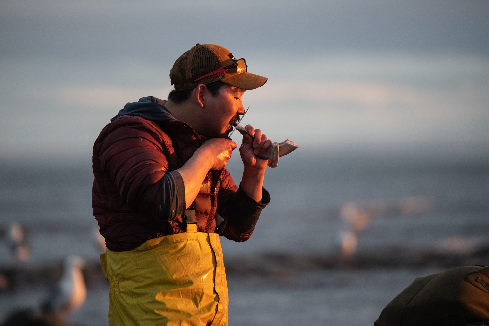
Andrew Muckpah, a Young Hunters program leader, cuts off a chunk of fresh beluga meat to chew on after a busy evening of hunting.
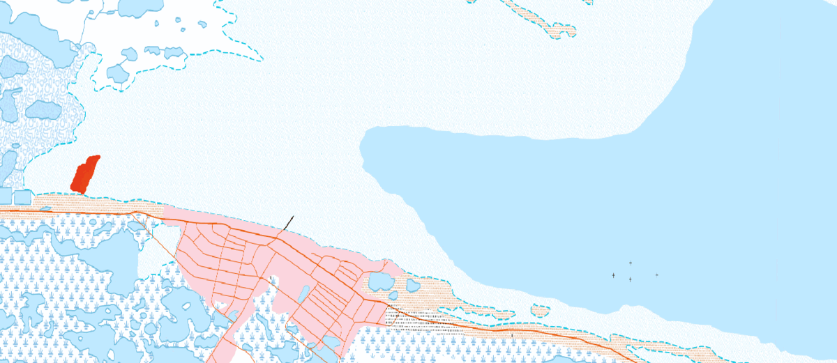
Unmarked hazards are a widespread problem for mariners off Canada’s north coast, where the lay of the sea bottom is woefully unknown. Only around 14 percent of the region’s waters have been adequately surveyed, according to the Canadian Hydrographic Service (CHS), the branch of Fisheries and Oceans Canada responsible for this task. Not only are updated charts vital to Indigenous communities like Arviat that rely on marine resources for subsistence, they’re also critical for commercial traffic—which has tripled across the Canadian Arctic in recent decades—and continues to climb as waning sea ice opens up new routes. For large vessels, an accident in these waters could unleash a dangerous and difficult-to-clean spill. And passenger rescues are challenging and costly, as at least two cruise ships that have run aground here in recent years show. But the expanse is enormous—the Canadian Arctic waters cover more than two million square kilometers, an area larger than Mexico—and mapping resources are thin.
“We will never have enough resources to cover the Arctic,” says Mathieu Rondeau, a CHS engineering project supervisor. Most methods of seabed mapping, such as with multibeam echo sounders and water-penetrating lidar, require expensive equipment and extensive training. High-traffic shipping and commercial fishing zones get top priority, leaving few resources for other areas—especially remote and relatively untraveled reaches of Hudson Bay. And with the seafloor steadily rising, charts here do grow out of date.
The only way this vast region can be fully mapped, Rondeau says, is with the help of citizen scientists. That’s where the Young Hunters come in.
As Muckpah and I speak, he’s piloting the Young Hunters’ motorboat in a grid pattern just off Arviat’s southern shore, following lines on a computer screen in front of him. It’s like pacing on water. A kilometer up, turn, 10 meters across, turn, a kilometer down, turn again. Repeat.
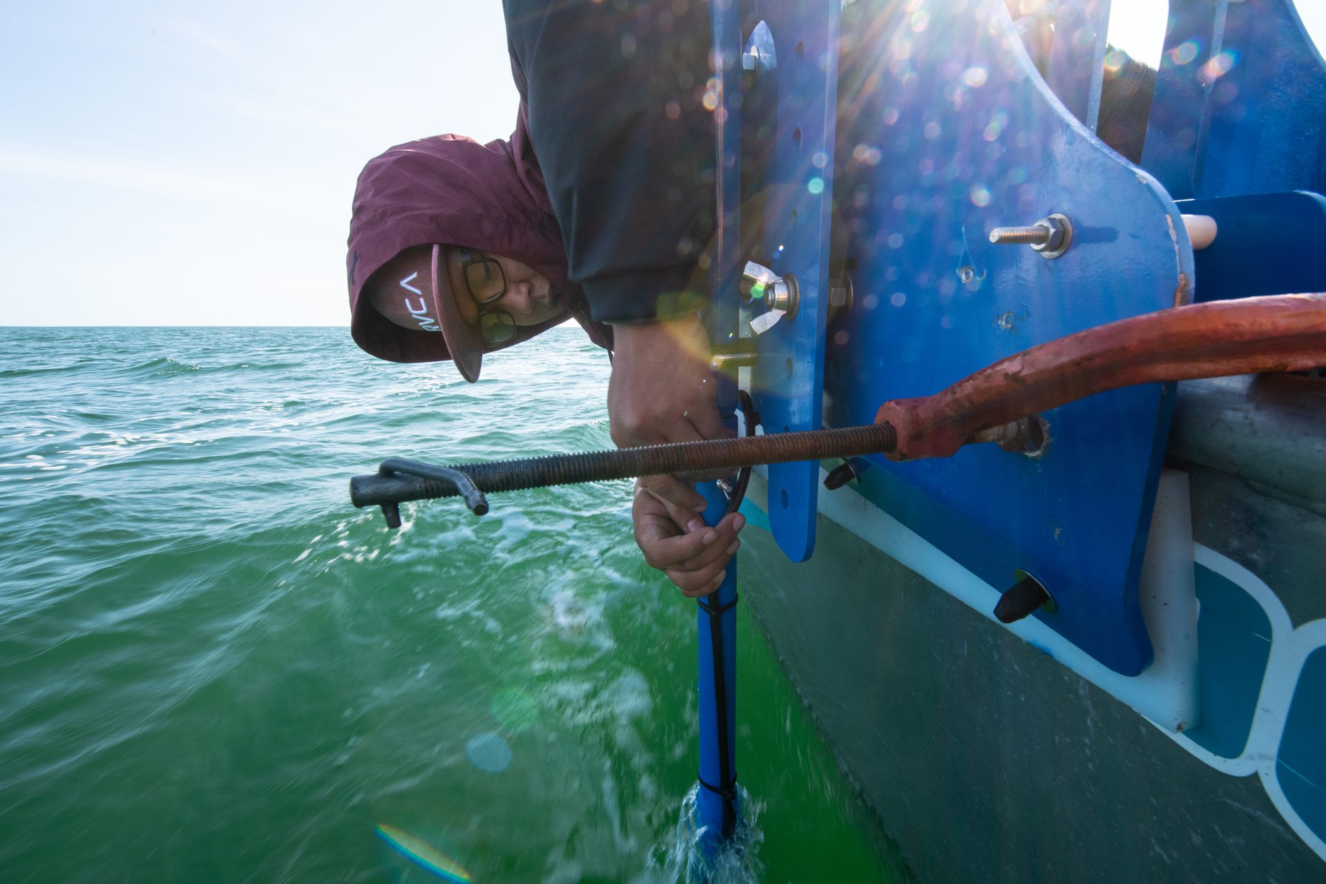
As he drives, sensors on a pole clamped to the side of the boat mark the precise position, gauge bottom depth, adjust for instrument-tilt from waves, and send the readings to a data logger. Instructor Irkok and Young Hunters helpers Lucas Owlijoot, Jacque John Mikiyungiak, and Joe Shamee keep an eye on the equipment and watch out for rocks. It’s the last day of August, and I’ve already left Arviat, but I tag along virtually, by smartphone.
Lucas Owlijoot, one of the young Arviat locals participating in his community’s coastal charting efforts, leans over the side of a boat to connect a portion of the HydroBlock system.
The surveying system, called HydroBlock, is designed to collect high-quality bathymetric data while being affordable and easy to use. The goal is to eventually enable coastal communities to create their own nautical charts, says Julien Desrochers, who is on board today as chief operating officer of M2Ocean, the Quebec company marketing the system.
Summer 2021 is the Young Hunters’ second year profiling Arviat’s underwater terrain with the HydroBlock. Desrochers is teaching them how to operate and maintain the equipment, decide where to survey, plan out their route, and gather data. In 2020, they surveyed 2.4 square kilometers, about half of the inlet near Arviat. The results were used to produce a bathymetric chart with shallow areas highlighted in bright red; it was posted for the public in the organization’s office and on its Facebook page. The data was submitted to the CHS, says Desrochers, who hopes the Young Hunters will go on to teach the techniques to other Indigenous coastal communities.
The project grew out of earlier research Aqqiumavvik Society board chair Tagalik had participated in, called Arctic Corridors and Northern Voices. That University of Ottawa–led study gathered Inuit knowledge on marine areas with cultural or ecological significance, to help design low-impact shipping routes for the increasing Arctic traffic. The findings showed the need for data on Arviat’s changing underwater landscape.
“It was increasingly unsafe to navigate those waters,” Tagalik says. But since Arviat is not on any core shipping routes, she realized that mapping the seabed here was a low priority for the government and maritime industry. The community would have to do it on its own.
Tagalik found her way to Desrochers, who was looking to test the community-geared hydrography system he was involved in developing with the Interdisciplinary Centre for the Development of Ocean Mapping. The Young Hunters’ first try, in 2019 with a precursor to the HydroBlock, didn’t go well, because Arviat’s waters were usually too choppy for the equipment to work properly. After trying the new system the following year, the program bought it. The government and charitable foundation grants that provide the organization’s main source of funds covered a small part of the cost, but the $36,000 total price tag for the equipment and training took a lot of extra fundraising, Tagalik says. The program hopes to acquire a second unit and expand its mapping efforts in the future.
Arviat’s project is a showcase for crowdsourced bathymetry: citizen scientist–boaters using their own navigational equipment to help fill in the missing details of the ocean floor, says Rondeau. At present, less than one-quarter of the global ocean has been surveyed, according to Seabed 2030, an international project aiming to map the entire ocean by the end of this decade. In addition to navigation, expanding knowledge of the subsea terrain is important for conservation, managing fisheries, and improving the accuracy of future climate models.
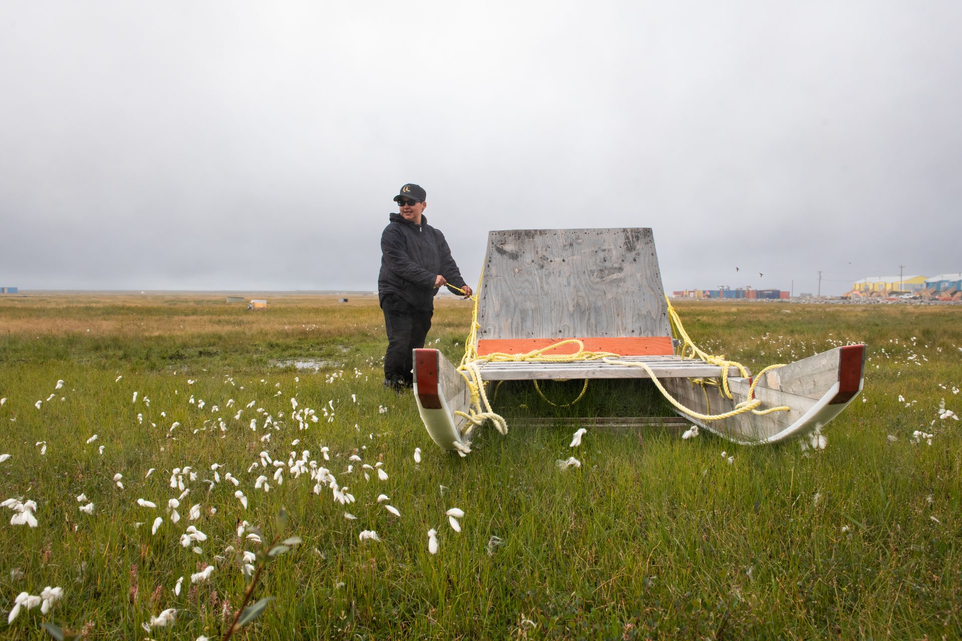
Mapping the bay is just one of the ways Inuit youth in Arviat are bridging Western and traditional knowledge systems to chart their changing world. In the winter, they contribute to SmartICE, a sea-ice-monitoring project conducted by Inuit communities along Canada’s northern coasts. Its high-tech guidance is needed as climate change disrupts long-standing experience of how to gauge ice safety. In a shed on a cotton grass–covered meadow, a qamutik (wooden sled) fitted with ice-thickness sensors waits for winter. When the bay freezes, the device will be towed over it with a snowmobile, mapping real-time ice conditions for a public app named SIKU. The Young Hunters also work with scientists to monitor wildlife health, analyze water quality, and collect other data on the changing environment.
Irkok adjusts rope attached to a qamutik, a traditional wooden sled, in a field of cotton grass on the outskirts of Arviat.
The tools are cutting edge but the skill—ujjiqsuiniq—is the timeless core of Inuit knowledge, says Kukik Baker, executive director of the Aqqiumavvik Society.
Baker, a youth outreach specialist, founded the Young Hunters program in 2012. She doesn’t like taking credit for it: “We [Inuit] are traditionally humble. We don’t boast about things that we do.” But Baker is a dynamo. As we speak in the small Aqqiumavvik Society office cluttered with papers and books, she fields a steady stream of visitors and phone calls, while two laptops whir in front of her. She handles it all with a patient smile.
Kukik Baker, executive director of the Aqqiumavvik Society, handles the demands of running the Young Hunters program with a smile.
In eight-week sessions held throughout the year, groups of middle schoolers, high schoolers, and young adults practice both high-tech and traditional ways of knowing, Baker tells me. While they’re in the boat mapping, for instance, they’re also observing wind and water, watching animal behavior, and reading the weather. “We want our kids to grow up to have skills to be able to use the best of both worlds,” she says. Around 200 Arviat youth have gone through the Young Hunters program as of summer 2021.
But charting this northern coast is challenging. The work can only be done during the brief summer window when there’s no ice. That’s the windy season, however, and conditions are often too rough for boats. Even on “good” days in the cold, blustery bay, equipment and operators can take a beating.
For the Young Hunters, tacking back and forth in a boat for hours collecting data is tedious. “It’s kind of boring, but fun,” middle schooler Don Don Ikakhik tells me one stormy Friday, as the group hangs out in the hamlet’s library, playing games on their phones and waiting to go home for lunch. It’s late August, the month named Akullirurvik, or Middle Season Moon, according to the calendar on the wall. The new school year is about to start.
“What’s the fun part?” I ask. “Going back,” Don Don replies.
To shore, that is. The others nod and laugh.
They do understand why it’s important. “So people will know where all the rocks and shoals are,” Rolanda says. But they’d much rather be out hunting. Hunting trumps everything when belugas are around.
Despite the challenges, these young Indigenous scientists are steadily building knowledge through research conducted at their own pace, on their own terms. They eventually go out 12 days in the summer of 2021, surveying another roughly three square kilometers. Another color-coded chart is posted on Facebook. The data is again shared with the CHS.
The community of Arviat’s mapping efforts in the waters directly in front of the hamlet spanned 12 days in the summer of 2021 and are represented in this animation. The shallowest areas, which emerge from the water at low tide, appear red, and the deepest waters—at least five meters deep—appear blue. Animation courtesy of Julien Desrochers
This summer, another group of novice Inuit hunters will pace the water in boats. And after freeze-up, they’ll haul high-tech qamutiks over the ice. They’ll not only be plotting safe routes to resources for their community and charting better navigation in the north, they’ll be mapping tomorrow’s Inuit identity onto the new face of their homeland.
Tea and conversation with Tagalik help me see how the wisdom of the Inuit ancestors sustains the environment today. As we sit in her cheery blue house overlooking the bay, she tells me the story of an elder who is walking in the countryside and sees a fox skeleton on the ground.
“‘Oh, you must be tired lying on that side all the time,’” she says, quoting the elder’s words to the fox. “And he turns it over.”
Shirley Tagalik, board chair of the Aqqiumavvik Society, which runs Young Hunters, knew her community needed a means of charting its own waters and helped bring HydroBlock technology to the hamlet.
Scientifically, Tagalik says, that action helps break down the bones and return their nutrients to the land. But to the elder, it’s a way of respecting the animal, as Inuit traditions direct.
Tagalik, a native of Quebec, is a longtime scholar of Inuit knowledge and culture. She moved to the hamlet as a young schoolteacher in the 1970s, intending to stay two years. Then she married an Inuk, embracing the language and way of life, and more than 45 years later, she’s still here. Over a bowl of cloudberries, we discuss Inuit Qaujimajatuqangit, and how it can inform the future guardians of this warming, transforming world.
“Being a good steward is almost self-serving in a way,” Tagalik continues. “Because what you put out in the world is what will come back to you. That’s a core belief.” In addition to respecting nature, she says, Inuit traditions emphasize paying close attention to the environment and carefully monitoring changes. And using innovative pirqutiit—tools and technology—to devise solutions or ways to adapt. The Young Hunters, she says, are learning to build all those principles into their lives.
Karetak also talks about respect when I ask him what Qallunaat—non-Inuit “southerners” in a place where almost everything is to the south—can learn from the guardians of this far-northern coast to help protect our natural world.
“You have to have a proper relationship with the land, as you would with another person that you respect,” he replies. “You don’t do things you think would offend the land.”
The Inuit way is to always treat the land with respect, says Karetak. Instilling that sensibility in the next generation is a key objective of the Young Hunters program.
Traditional Inuit laws treat the land as a living entity with the same legal standing as humans, says Karetak, who has spent years researching the unwritten directives that were lost to colonialism. A strict set of location-specific rules governed land use, such as how long people could stay in one place before they had to move on and let the land recover. While most of those laws applied to a nomadic lifestyle that is no longer possible, he says, the core environmental stewardship principle remains.
“It’s simply based on what the land and water can provide,” says Karetak. “You let the land and water take care of itself. So you take only what you need and can handle well.”
Irkok teaches the Young Hunters much the same.
“One of the duties of Inuit Qaujimajatuqangit is respecting your surroundings,” she tells me. “We try and teach them Inuit ways. For example, if we find six eggs [in a nest], we’ll take three.”
Respect your surroundings. Treat the land as a kindred being. Read and respond to the environment’s needs. Place-based principles and practices like these have guided Indigenous land stewards for generations. Long disregarded by Western scientists and land managers, appreciation of this deep well of ecological knowledge is growing. New national initiatives, such as Canada’s Indigenous protected and conserved areas—one of which is being created in the Seal River watershed just south of Arviat—are giving Indigenous communities new agency to manage their ancestral lands and waters. Traditional knowledge is being incorporated into scientific research, and the concept of nature having legal personhood and rights is now finding its way into Western law.
But for the next generation of Indigenous land stewards, the challenge is to keep that venerable wisdom alive.
Like young people everywhere, Inuit youth today are tethered to the internet, glued to their mobile phones. “They do have more of the Western culture than they do our traditional one,” says Baker. They are adept with technology and quick to catch on to the latest gear. But to gain Inuit Qaujimajatuqangit, she says, they need to reconnect to the land.
That means following the path of their ancestors to become Inuit hunters. It means learning traditional Inuktitut place names, and the place-based knowledge those names convey. It means making their own pana, or snow knife, and knowing how to use it to build a life-saving shelter in a winter storm. It means knowing the rhythms of the ecosystem like they know their family’s habits, being as familiar with the landscape as with their own skin. Above all, it means spending time with elders and hearing the stories teaching Inuit wisdom and ways.
“It’s helping them to come back to the beginning,” Baker says. “Going back over the bridge backwards.”
Up here, where the world is redrawing itself, the bridge to the past provides hope for the future.
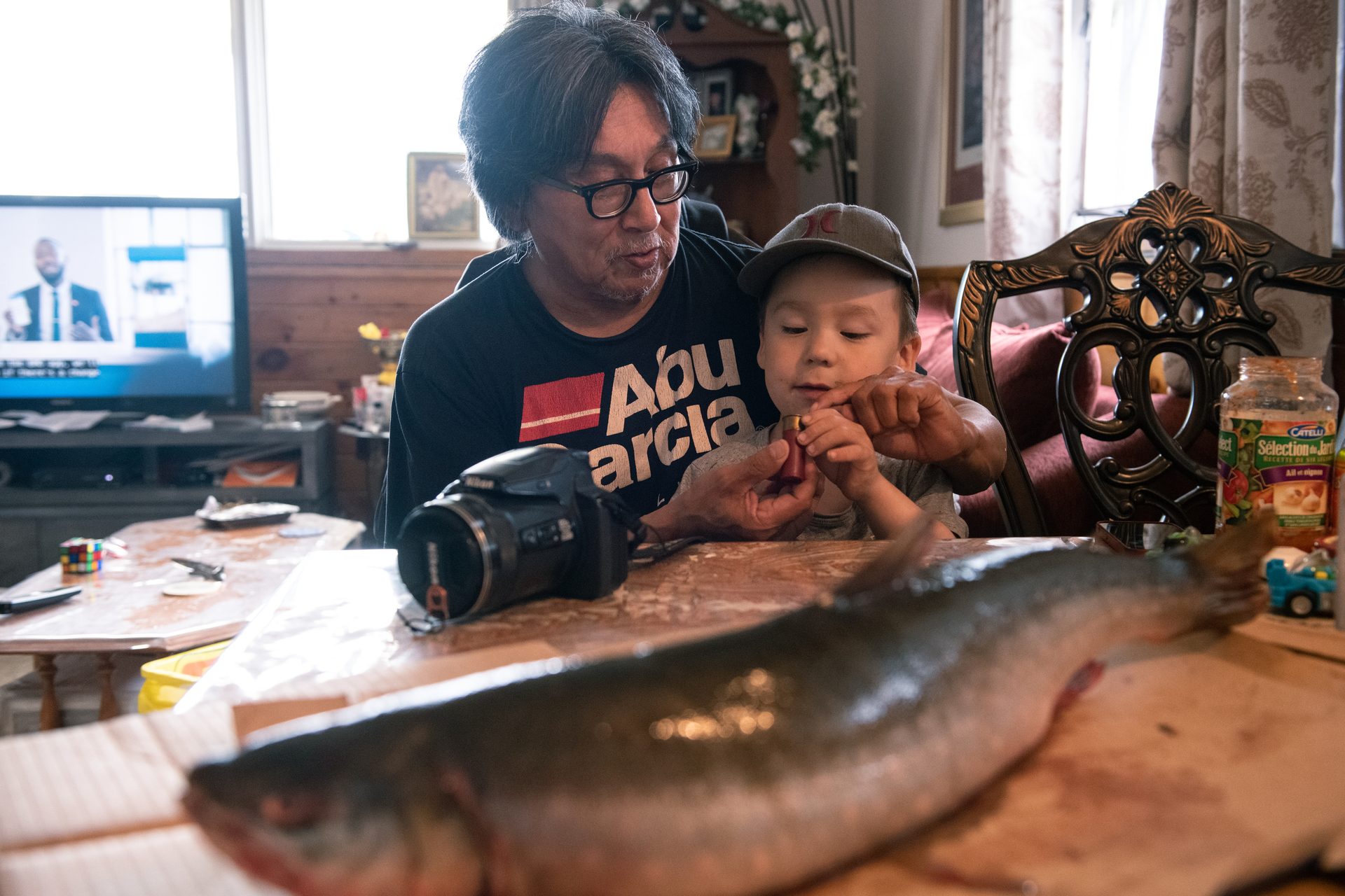
Hunter Gordy Kidlapic sits at his kitchen table with his young grandson in his lap. Over an immense fresh Arctic char splayed across the tabletop between us, we discuss how the impacts of old and new climate change—one driven by nature, the other largely by the actions of Qallunaat—are combining. Already Kidlapic sees signs of a one-two punch on life around Arviat. Animals are changing “big time,” he tells me. Some fish, like the one in front of him, seem to be growing larger in the shallowing, warming bay, while other local marine life is being driven out. He’s seen a pod of around 50 killer whales causing seals and other sea mammals to “kind of run away.” On the tundra, a once-reliable hunting spot sports more plants and fewer caribou these days. And he’s worried by the polar bears that now roam the coastlands for months.
Arviat hunter Gordy Kidlapic hopes to teach his young grandson, Victor, how to harvest from and care for the changing environment around them.
Still, his grandson is eager to hunt, and Kidlapic is beginning to teach him. “I think he’ll be all right,” he says.
Back on deck, Rolanda hears shouts and cheers. Don Don, who’s on another boat, has just gotten his first qinalugaq. Now it’s her turn. She watches the water. The long line of Inuit hunters in her family stands behind her.
Now there’s a bulging wave. An arc of gray. A spout. Rolanda hurls the harpoon.


 Depiction of metric ENC depth contours
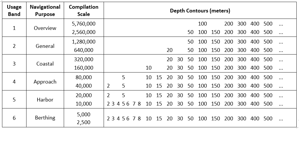
 Figure
4: Coastal bathymetry, St.
Figure
4: Coastal bathymetry, St.
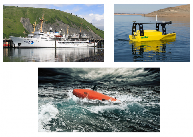 Figure 1: Platforms used in hydrographic surveys: (a) NOAA Ship Fairweather for offshore surveys, (b) EchoBoat-ASV from Seafloor Systems, (c) Hugin AUV from Kongsberg.
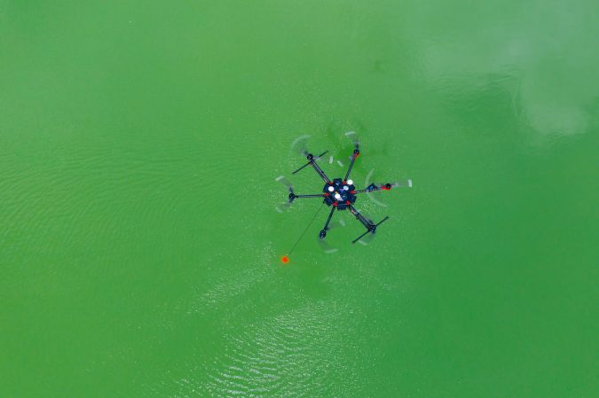 Figure 2: Integrated system for bathymetry using an echosounder in a UAV.
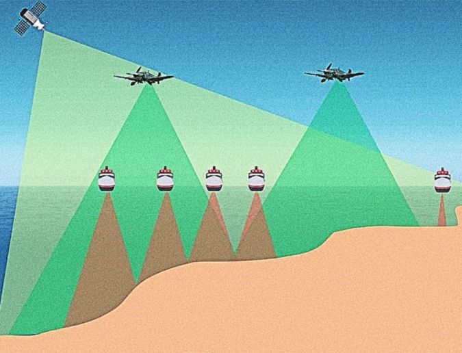 Figure 3: Different methodologies for extraction of bathymetry, exemplifying the high productivity of optical remote sensing.
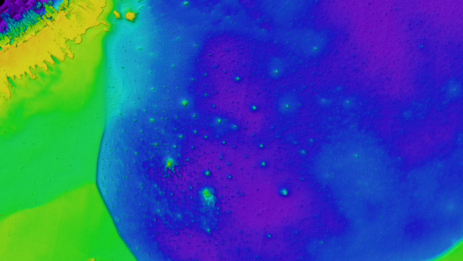 Bathymetric Lidar is one of the solutions to address governments' coastal, riverine and shallow-water geospatial and hydrographic needs.
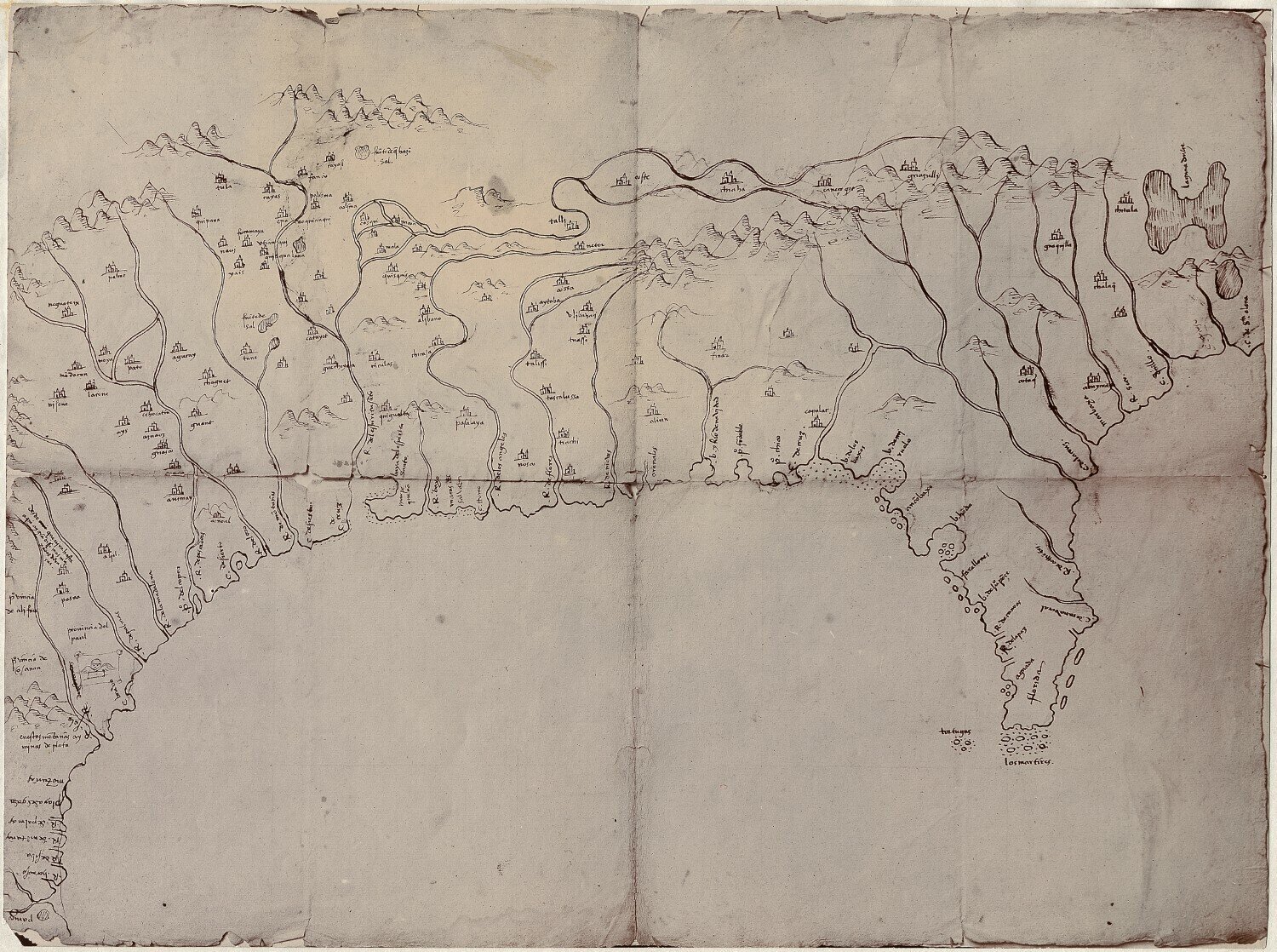


