Saturday, May 7, 2022

What is bathymetry?


Bathymetry is the science of measuring the depth of water in ocean, river and lake environments.
Learn how USGS measures bathymetry in this video by the St. Petersburg Coastal and Marine Science Center, originally created for the 2021 virtual St. Petersburg Science Festival.

Friday, May 6, 2022

Ice lost, island found?


NASA Earth Observatory images by Joshua Stevens, using Landsat data from the U.S. Geological Survey, and ICESat-2 data from the National Snow & Ice Center
 
From NASA by Kathryn Hansen, with information from Christopher Shuman (NASA GSFC/UMBC JCET)


Localization with the GeoGarage platform (NGA nautical raster chart)

The eastern coast of Antarctica has lost most of the Glenzer and Conger ice shelves.
In the process, it gained what is likely an island. If confirmed, the unnamed island would be one in a series of islands exposed in recent years as portions of the floating glacial ice hugging the continent’s coast have disintegrated.

The candidate island is visible in this triptych of images acquired by Landsat satellites between 1989 and 2022.
The images are a combination of shortwave infrared and visible light, and were adjusted for consistency in brightness and color.
Notice how the island has maintained the same shape, even after shelf ice detached from it, and as sea ice around it waxed and waned.
That round white mound has not budged, even after large icebergs likely smashed into it following the rapid collapse of the Glenzer and Conger ice shelves this year.

The feature also appears taller than its surroundings.
The elevation profile below indicates that at least part of the mass stands 30 to 35 meters (100 to 115 feet) above the surface of the sea.
The data were acquired on December 22, 2021, with the Advanced Topographic Laser Altimeter System (ATLAS) on NASA’s Ice, Cloud, and land Elevation Satellite 2 (ICESat-2). 


December 22, 2021 - January 9, 2022

But just because a feature acts like an island and looks like an island, does not mean it is an island—at least not in the traditional sense. Scientists are still unsure if there is any solid earth breaching the sea surface below all of the snow and ice.

John Gibson, a scientist with the Australian Antarctic Division, thinks the feature is likely an ice island: a large, heavy cap of ice sitting solidly on an underwater peak.
 “It is undoubtedly similar to other ice islands, such as Bowman Island,” Gibson said.

Gibson called the ice island “self-perpetuating,” meaning that snow and ice accumulating on the island’s surface balances out the amount of melting that occurs underwater.
If that balance becomes disrupted by a decrease in snowfall, then the ice island could thin and float away.
“The unnamed island is a more-or-less permanent feature of the landscape,” Gibson said, “but may someday detach from the underlying rock and become an iceberg.”

Without anyone having been there to observe the island, questions remain about its structure.
 “To be absolutely sure, you would need to put a ship next to it to check for a bedrock outcrop, and maybe a radar over it to assess the ice thickness,” said Christopher Shuman, a University of Maryland, Baltimore County, glaciologist based at NASA’s Goddard Space Flight Center. 
“The ICESat-2 profile shows that the surface is well above sea level. That would be a whole lot of ‘ice cream’ above the ‘cone’ if there wasn’t bedrock at or above sea level.”

Traditional or ice, the island is the latest in a bunch of similar features that are no longer embedded in Antarctica’s floating glacial ice.
In 2019, the U.S. Board on Geographic Names recognized Icebreaker Island, which in 1996 became isolated from the Larsen B Ice Shelf along the Antarctic Peninsula.
And in 2020, researchers on a ship-based expedition discovered a small, rocky island capped with ice that may have been part of Pine Island Glacier’s ice shelf.

“The discovery of more of them is likely to continue in the years ahead due to shrinking glacial and sea ice,” Shuman said. 
“Obviously these are ‘new to us’ features, but we also have more people and more tools to look at the margins of Antarctica now. Several examples do not make a trend, but they do imply that other once-hidden features are likely to be noticed in the years to come.”

Links :

Thursday, May 5, 2022

More serious questions raised about the ATSB's review of MH370 data

 
 From Airlineratings by Geoffrey Thomas
 
More questions are being raised about the ATSB’s review of MH370 search data with, incredibly, the two maps in its report apparently showing different, and both incorrect, locations of Mr Richard Godfrey’s proposed site of MH370 with the maps out of sync with the original search map issued in 2017.

On Friday, April 22, 2022, the Australia Transport Safety Bureau issued the report of the review of its search data by Geoscience Australia in response to Mr Godfrey’s proposed location of MH370 based on his revolutionary MH370 tracking using WSPRnet technology.

The ATSB stated that; “The Geoscience Australia report notes that it is highly unlikely that there is an aircraft debris field within the area reviewed.”

But the review only looked at 29 per cent of the requested area and the report also stated multiple times that “further data acquisition” and “additional data acquisition” are required.

Even more serious are the disturbing inconsistencies when you compare the ATSB’s report titled “The Operational Search for MH370” dated October 3, 2017, to the Geoscience report titled “MH370 Data Review – Final Report” dated March 8, 2022, with the maps of the underwater search area apparently totally out of alignment.
 
 zoom 

 Localization with the GeoGarage platform and Scripps bathymetric profile (STRM15)
 

The proposed crash location 33.177°S 95.300°E has apparently moved 23.8 km further southwest on the current Geoscience maps as shown below.

A closer examination of the ATSB report also reveals the following
The bathymetry maps from ATSB and Geoscience Australia are different.
The latitude and longitude positions of the bathymetry maps differ.
The position of the crash location on the bathymetry maps included in the latest Geoscience report is wrong using the latitude and longitude shown on their maps.
The position of the crash location on the bathymetry maps included in the latest Geoscience report is wrong both in the wide-area view and the narrow area close up view with differing errors.

Here is that ATSB graphic from 2017 showing Mr Godfrey’s proposed MH370 location where the two red dotted lines meet.
To the left and south is the “same location” according to the latest report done by Geoscience Australia on behalf of the ATSB.


The two maps from the new review report with the “supposed correct location” shown by the yellow dotted lines are below.
But this location is different using the latitude and longitude used in the ATSB graphic from its 2017 report which everyone has been using as a reference.

In Geoscience’s first map in the report issued Friday, April 22 this new – and likely incorrect – location for the latitude and longitude is indicated by the yellow dotted lines yet Geoscience positions the location six nautical miles to the southwest.


In the second map in the same report, the location is now four nautical miles to the southeast of the “proposed site” which again is marked by the yellow dotted lines but as stated this also differs from the original report.


Here is the same map showing where Mr Godfrey’s location is according to the original ATSB 2017 map.


Mr Godfrey told AirlineRatings.com that “if it is true that the proposed crash location has been incorrectly mapped twice in the new report, then my confidence in the report’s findings dwindles”.
 
Famous wreck hunter Blaine Gibson who has found more MH370 debris than any other person said “what really bothers me is why a “Final Report” dated March 8, 2022, is held until April 22 and quickly released in such sloppy incomplete form, and with only 29 per cent reviewed.
“I have gotten used to brilliant fast professional work of ATSB in identifying and analysing MH370 debris. This is a departure from that standard.” 

Links :

Wednesday, May 4, 2022

The world's most challenging cruise ship routes


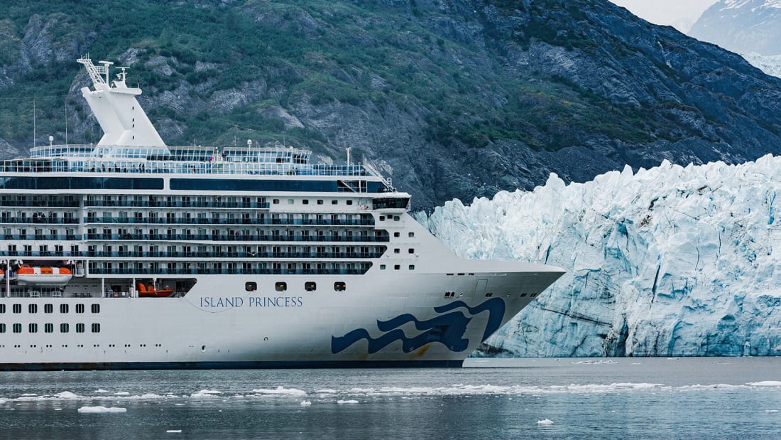
A cruise ship sails in front of Margerie Glacier in Glacier Bay, Alaska.
Photo credit: Tim Rue/Bloomberg via Getty Images
 
From CNN by

Editor's Note — Monthly Ticket is a new CNN Travel series that spotlights some of the most fascinating topics in the travel world.
In April, we're setting course for the diverse world of cruises.
Whether you're looking for travel inspiration or insider knowledge, Monthly Ticket will take you there.
(CNN) — Navigating a colossal ship is no mean feat under any conditions, but certain routes, like the sandstorm-prone, narrow Suez Canal -- infamously blocked by a container ship last year -- or the windy, glacier-lined waterways of Alaska, are particularly challenging.
Andy Winbow, a master mariner who has helmed vessels across the globe, tells CNN Travel that trickier routes are often characterized by "adverse weather conditions, a lack of room to maneuver due to natural hazards and a lack of navigational aids."
These factors will impact any vessel, but multi-decked cruise ships can be more affected due to their sheer bulk.

"The higher the ship, the bigger the windage," is how David Pembridge puts it.
Pembridge is a retired cruise ship captain who worked for decades on ships operated by P&O Cruises and Princess Cruises.
When tall ships are buffeted by wind, they're prone to slide slipping -- a term used to describe a ship that's being blown sideways.
To counteract this effect, the ship has to be steered at an angle.

This maneuver is extra tricky when traversing a waterway like the Suez Canal or the Panama Canal.
In these narrow channels, ships should also avoid hitting the sides of the canal.
"If they go through at speed, it causes erosion of the banks, and drags some of the sand away from the sides and into the center of the canal, which is no good because it makes it less deep, so it causes shallowing," explains Pembridge.


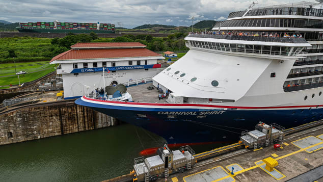
A cruise ship navigates through the Panama Canal on April 23, 2022.
LUIS ACOSTA/AFP/AFP via Getty Images

While the Suez Canal and the Panama Canal have some unifying features, there are also key differences between the Egyptian waterway and the South American channel.

Where the Panama Canal is largely bordered by forest and vegetation, the Suez is flanked by flat desert, meaning there's potential for poor visibility caused by sandstorms.
And while the 120-mile Suez is largely straight, the roughly 50-mile Panama Canal "winds in and out of islands," as Pembridge puts it, with this topography adding another dimension to the challenge.
"It's a different sort of difficulty, but it still requires fairly intense concentration going through there," explains Pembridge.
Ships traversing the Panama Canal must also pass through three different sets of locks.
In more recent years the locks were widened to better accommodate bigger ships, but when Pembridge was sailing the route regularly, his vessel would be separated from the sides of the lock by only a couple of feet.
In Panama, mechanical locomotives also help tow cruise ships through the locks, while in especially narrow sections of the Suez, tug boats help guide larger ships.

"It's normally a long day for the team on board, because you start and you don't stop until you get through the other end," says Pembridge of passing through both channels.

The role of the pilot


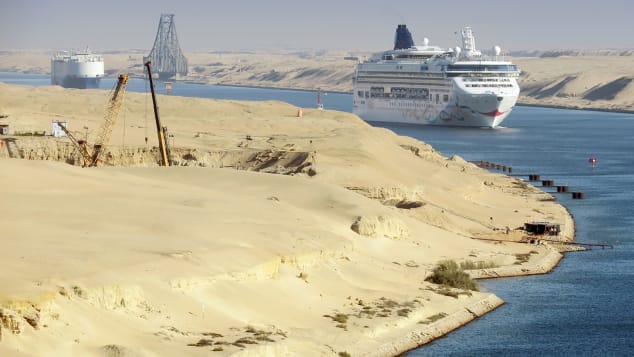
Cruise ships are helped down the Suez Canal by local expert seafarers, called marine pilots.
Soeren Stache/picture-alliance/dpa/AP

All vessels operating in the Suez and the Panama are aided by local mariners.
These seafarers, known as marine pilots, board the ship at the start of the channel and work together with the on board crew to ensure safe passage.
The Suez Canal and the Panama Canal are both "compulsory pilotage areas" -- meaning pilots aren't optional, they're required by law.
Pembridge suggests the working relationship between pilots and captains isn't always smooth sailing.
"That's one of the helps, and one of the hindrances, at times, depending upon the level of competency and personalities involved," he says.

"The pilot legally must direct the cause and speed of the vessel.
But at the same time, the master of the vessel always has the responsibility for the safe navigation of the vessel and that can't be abrogated to the pilot."
In some areas, the pilot's role is less crucial, and not necessarily a legal requirement.
But in more challenging ports and waterways -- such as Suez and Panama, or the waterways around Alaska, their role is essential.


Captain John Herring was captain of a research vessel before he become a marine pilot in southeast Alaska.
Herring tells CNN Travel there are two key reasons why pilots need to be on board ships in certain areas.
"First, we provide local knowledge of route dangers, tides and currents, weather, concentrations of marine life, and more," he explains.
"Second, being independent from the ship, we bring objective decision making not subject to the economic pressures of the ship's schedule.
Captains are experts on their own ships and we are experts on Alaskan waters."
Southeast Alaska is a compulsory pilotage area, partly because it's prone to strong winds and currents, and partly because of its marine ecosystem.
"Alaska coastal waters are blessed with an abundance of marine mammals," says Herring.
"Whale watching is a favorite pastime for passengers, but it requires constant vigilance on the bridge to avoid close encounters."
Similarly, spotting icebergs and glaciers might be a highlight of an Alaskan cruise, but these icy formations can cause difficulties for vessels.
"That ice is hard and can damage the hull or propellers," explains Herring, adding that strong winds and currents make navigating icy waters even harder.

In recent years, technology has advanced, making navigating unpredictable routes a bit easier for vessels.
But Herring suggests pilots are still integral in the age of satellite technology.

"The local pilot can still bring the ship safely to port without GPS," he says.

Depth of water and local topography


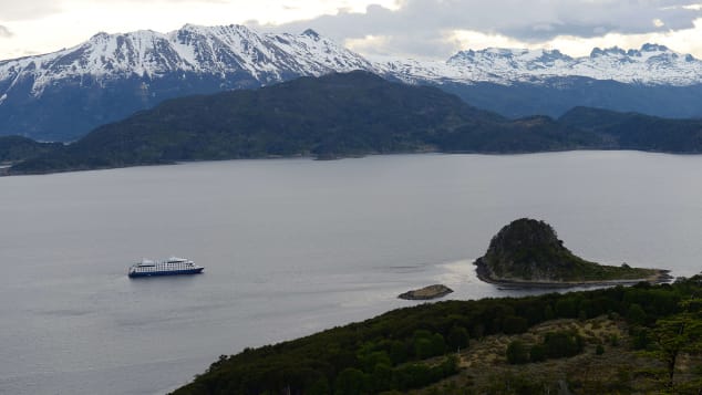
The fjords and channels of Chile, including the Murray Channel in southern Chile, pictured here, can pose particular challenges for vessels.
Wolfgang Kaehler/LightRocket/Getty Images

Ships sailing around Alaska must also contend with varying water depths.
In shallow water channels, ships need to move slowly to avoid creating a low-pressure zone under the vessel that could cause the ship to ground on the seabed.
"Ships can 'squat' if traveling too fast and thus have insufficient clearance under the keel," is how master mariner Andy Winbow explains it.
Cruise routes around the Norwegian fjords and the fjords and channels of Chile also involve navigating occasional shallow waters.

Can you steer a ship through the Suez Canal?

Other cruise ship routes present issues because their topography is constantly changing.
Pembridge gives the example of the Amazon River, sections of which are sometimes traversed on South American cruises.

"The bottom of the Amazon moves around continuously and so on a nautical chart it will show an island, and when you get there the island won't be there, it'll have moved somewhere else," he explains.
"It's very much dependent on the pilots then -- the local pilots are people that know the river and know how it's moved."
City ports can also pose challenges.
Pembridge points to the Dutch ports of Amsterdam and Rotterdam and the German port of Hamburg, as well as Ho Chi Minh City in Vietnam.
To dock in any of these cities, cruise ships must first traverse a narrow channel, and how easy that is largely depends on weather conditions.

Planning and unexpected moments


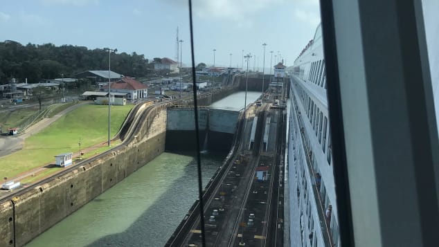
Pembridge took this photo of one the Panama Canal locks while at the helm of P&O Cruises' MV Aurora cruise ship.
David Pembridge

A solid voyage plan is essential to smooth sailing.
Pembridge explains that cruise ship passage plans are usually devised by a junior officer, and then approved by the captain.
Plans will always take into account any known potential challenges -- like wind, width of waterway, tides and surrounding terrain.

"If you're in open ocean, it's a relatively simple briefing -- this is the course we intend to take, this is the speed we intend to be doing.
Once you get closer to land, and it becomes more involved, then you start to highlight dangers, any currents, and the likely weather effects of anything," says Pembridge.
"And then as you get into really confined waters -- which is what the [Suez and Panama] canals are -- then it's a much more intense briefing."
The threat of piracy is another factor that's taken into consideration, although Pembridge suggests it's less of an issue than it once was.
He recalls helming ships that sped through the Gulf of Arden at flank speed, turning lights out at night and organizing passenger drills.


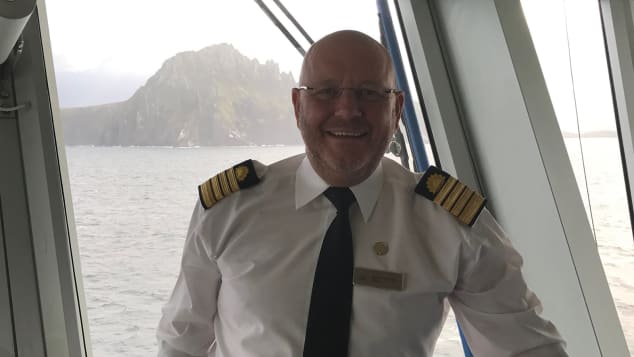
Captain David Pembridge, who retired in 2020, pictured near Chile's Cape Horn.
David Pembridge


Weather is also taken into account when voyage planning, but all the preparation in the world can't totally account for the unexpected.
Pembridge recalls a time he was captaining a ship sailing from the Falkland Islands towards South America.
Wind was forecast to be strong, but when night fell, the violent gusts were much fiercer than expected.
All through the night, Pembridge and his team slowly angled into the waves to try and counteract the impact of the wind.
When daylight drew in, they saw the extent of what they were dealing with.

"They were very, very big waves.
And the front of the ship was burying itself into them and coming up again, it was perfectly safe, but very uncomfortable."
By the time the weather had receded, the ship had veered some 30 miles off course.
Ports had to be rearranged and the voyage replanned.
But Pembridge points out that while vessels might encounter unexpected challenges, the vessels and the people in charge are generally prepared for obstacles.
"Modern cruise ships are well equipped to deal with pretty much all of the challenges that come their way," says Pembridge.

Links :

Tuesday, May 3, 2022

Inside the secretive Silicon Valley startup trying to save the oceans with tech


From TechCrunch by Mark Harris

Lucy Southworth's Oceankind is now one of the biggest NGO funders of ocean science in the world

When Matthew Dunbabin saw the devastation wrought on tropical reef ecosystems by overfishing and climate change, he wondered if robots could help.
With money from the Queensland University of Technology, where he is a professor of robotics, Dunbabin’s team developed a prototype underwater robot to reseed dying reefs with tiny coral larvae.

While initial results were promising, prospects for actually deploying the bots seemed dim.
“Universities can get stuck into three-year funding cycles,” he told TechCrunch.
“But global issues can’t wait three years.”

Then in 2019, Dunbabin was approached by Oceankind, a mysterious new ocean philanthropy organization that promised to accelerate his efforts.

“They saw what we were doing and said, ‘what do you need to scale?’ And they wanted it to be quick,” he said.

In rapid succession, Oceankind provided three grants totaling almost $2 million to iterate the robot’s design, add machine learning capabilities and transform it into a multi-functional autonomous underwater reef restoration system, intuitive enough to be operated by citizen scientists.

Queensland’s CoralBots are now being put to work in Australia, the Philippines, Vietnam and the Maldives.

“What I like about Oceankind is that they recognize the true cost of doing technology projects and they’re prepared to support it,” said Dunbabin.
“They’ve been absolutely a dream funder.”

Until this week, Dunbabin was not allowed to mention Oceankind.
Instead, the Great Barrier Reef Foundation, which also received a separate $1 million donation from Oceankind, took public credit for the robot research.
While Dunbabin can now give full credit to Oceankind for the funding, he is still unwilling to identify the Silicon Valley power couple behind the organization.

An examination of California state filings show that Oceankind was incorporated as an LLC in 2018, managed by a family office that controls many of Google co-founder Larry Page’s properties and businesses.

But it was only last week that Oceankind’s website was updated to indicate that it was actually Page’s wife, Lucy Southworth, a research geneticist by profession, who founded and directs the organization.

The website also now details how Oceankind has spent more than $121 million funding a broad range of projects related to marine science, technology, animal life and climate.
That makes Oceankind one of the biggest non-governmental funders of ocean science in the world.

 
Casting a wide net for science

Oceankind’s stated mission is “to improve the health of global ocean ecosystems while supporting the livelihoods of people who rely on them.
“We seek to advance the policy, science, and technology necessary to reverse the growing threats facing our oceans.”

Oceankind’s list of grants shows the organization casting its net widely, funding everything from off-shore wind farms in Japan to cell-based seafood research.

Oceankind has supported diversity and representation efforts, funded research into sewage control and sustainable fisheries, and made grants to science programs from the Arctic Ocean to the tropics.
One Oceankind project that may raise eyebrows is its funding of research that strays into the controversial area of geoengineering.

In September 2019, Oceankind convened a conference of ecologists, biochemists and climate experts to look into ocean alkalinity enhancement (OAE).

As well as warming the planet, rising levels of carbon dioxide are acidifying the oceans, threatening shellfish populations and delicate ecosystems like coral reefs.
OAE involves adding large quantities of ground-up alkaline rock into seawater, where it would react with excess CO2to form bicarbonates that sea creatures use to form their skeletons and shells.
These should ultimately end as sediment on the seafloor, storing the carbon for millennia.

Although OAE is still mostly at a theoretical and experimental stage, deploying it at scale would be a massive undertaking.

The official report from Oceankind’s conference noted that it could require five billion tons of rock annually, which is about twice the quantity currently used in global cement production.

Few attendees at the conference knew that Oceankind had a connection to Page, who, as the seventh richest personin the world, is in a position to personally fund a significant geoengineering program.

The conference ultimately concluded that very wealthy donors could consider “large-scale demonstrations” to validate the effectiveness of OAE at scale.

Oceankind has given marine science nonprofit ClimateWorks grants totaling at least $18.
2 million, dedicated to decarbonizing shipping, carbon dioxide removal and OAE.

ClimateWorks in turn recently made grants for limited OAE field experiments.


The mystery of Oceankind’s money

Larry Page has long had a charitable foundation, named after his deceased father, of which he and Southworth are both directors.

Over the last decade, that foundation has given hundreds of millions of dollars to donor-advised funds — tax-efficient charitable vehicles that are not required to disclose where the money eventually ends up.

Moreover, Oceankind itself is not a nonprofit, which are required to open their books every year in public filings to the IRS.

Instead, Southworth incorporated Oceankind as a limited liability company (LLC), making it virtually opaque to public scrutiny.

It is thus impossible to know how much, if any, of Page’s Google fortune has ended up at Oceankind.

However, TechCrunch could find no indication in public records of traditional nonprofits or government agencies providing Oceankind with any funds.

Oceankind confirmed to TechCrunch that Southworth resources it, and supports its executive director in leading the organization, but spokesperson Nina Lagpacan did not respond to questions regarding the ultimate source of its funding.

She did provide TechCrunch with this statement: “Oceankind is not seeking visibility nor conducting media interviews at this time.
”This lack of transparency worries some experts in philanthropy.
“Is it appropriate to put this kind of research into the hands of billionaires for them to be the drivers of it financially?” asks Stephen Gardiner, a professor of philosophy at the University of Washington and author of A Perfect Moral Storm: The Ethical Tragedy of Climate Change.
“I wonder about what sorts of accountability are in place, what sorts of power they might be exercising over what’s being done and how.”

Page and his family are reported to have spent much of the pandemic in Fiji.
Last year, Page was granted New Zealand residency, where one of his eVTOL startups, Wisk Aero, recently completed flight tests.

“I don’t know anything about Larry Page’s preferences,” says Gardiner.
“But if he’s in favor of some kinds of interference with the ocean but against others, that could influence the research agenda in a way you might not see if projects were being run through national science foundations or other institutions with more accountability and political legitimacy.”

On the flip side, Oceankind does seem to be empowering valuable initiatives that might otherwise languish.

In 2021, Oceankind gave $100,000 to SkyTruth, a nonprofit environmental watchdog that uses remote sensing data to identify and monitor threats to the planet’s natural resources.

The funds were to help it operationalize a system called Cerulean that tracks oil slicks back to individual ships at sea.

Over its first year of operation, Cerulean positively identified 187 vessels responsible for deliberate oil slicks, using satellite data, machine learning and human experts.“I’m confident the project would have happened anyway because it’s a great idea,” said John Amos, president of SkyTruth.

“But it’s hard to say if we would have fleshed out this great idea as compellingly, if we hadn’t had support from Oceankind.”

Amos hopes that Oceankind will continue to support Cerulean as SkyTruth expands its oil slick tracking, eventually to a global scale.And from now on, it seems that the billionaires behind it will no longer hide beneath the waves.

Links :

Monday, May 2, 2022

Map orientation: North is not always up


Scientists use a widely accepted way of presenting Antarctica so there's a standard "north" to use as reference.
This "north" is established from the fact that the continent is split into the formally named "West Antarctica" and "East Antarctica". 
These regions mostly align with which hemisphere they fall into and are separated nicely by the Transantarctic Mountains. 
"West Antarctica" and "East Antarctica" were first named during Antarctic expeditions in the early 1900s. 
They were formally approved in 1962 by the Advisory Committee on Antarctic Names, an advisory committee of the U.S. Board on Geographic Names.

From Geography Answers

Most people are used to looking at maps where north is at the top of the map.
In the history of cartography, the tradition of orienting maps so that north is at the top of the page has not always the common practice.

North Orientation Maps

Greco-Roman cartographers such as Claudia Ptolemy (90-168 AD), who is credited with creating the first known atlas with his collection of cartographic works in the multi volume "Geographia", set an early tradition of using a north orientation on maps.
Subsequent eras of cartographers in the Middle Ages tended to use a south or east orientation.
The Great Age of Exploration marked a return to orienting maps with north at the top as the need for seafaring explorers to orient themselves with their compasses became important.
The importance of orienting maps towards the north was a reflection of the importance of knowing where magnetic north was.
Today, a north orientation is commonplace among cartographers.

East Orientation Maps

An east orientation was customary during the Middle Ages, especially in Europe.
In fact, the world "orient" comes from the Latin word "oriens", meaning East.
Examples of maps with an east orientation are the Mappa Mundi (Medieval European world maps) such as the T-O map.
The T-O maps was a symbolic representation of the world, with the O representing boundary of the world, encircled by the earth's oceans.
The T nested inside the O divided the world into the Northern Hemispheres' three continents: Asia at the top, Europe to the left, and Africa to the right (the southern hemisphere was ignored as it was considered inhabitable at the time).
The horizontal bar of the T represented the Mediterranean Sea and the vertical portion of the T the Nile and Don Rivers.
Heavily influenced by Christianity, European cartographers in medieval times oriented the maps so that east was at the top where the sun rose and the Paradise was thought to lie.

 Upside down map of the world with the mysterious continent "Java la Grande", 
Nicolas Desliens, 1566 
source BNF

South-up Map Orientation

South-up maps (also known as reverse maps) flip continents so that to those used to seeing North at the top, the map appears upside down.
South is oriented the top of the map, east is towards the left of the map and west towards the right.

Showing south at the map orientation was common among Arab cartographers like Ibn Hawqal who in the tenth century created a world map with south at the top.
The Moroccan cartographer, Muhammad al-Idrisi, drew a world map in 1154 commonly known as "Tabula Rogeriana" (Book of Roger) for King Roger II of Sicily, showing south at the top of the map.

Cartographers from the Dieppe School of Cartography in the 16th century produced table maps with a south orientation.
Pierre Desceliers, a French cartographer during the Renaissance creating a world map in 1550 meant to be viewed around a table and showed parts of the world turn towards the south.
In 1566 Nicolas Desliens also created a map of the world showing south towards the top.
The map is currently housed in the Bibliothèque Nationale in Paris.

In contemporary cartography, south-up maps are mostly created to protest Western Hemisphere bias in some world maps.
For example, in the West Wing's second season episode, "Somebody's Going to Emergency, Somebody's Going to Jail" a south-up Peters projection map is featured in a presentation by the fictitious Organization of Cartographers for Social Equality which advocated for the mandated use of the Peters map projection in elementary school geography courses as a more realistic representation of the world. 


Map of West Africa, 1540s (the map is drawn 'upside down')
 
No Unified Orientation

Maps produced during the Golden Age of Japanese Cartography from the 1600s to around 1855 had no standard orientation.

Many maps had a center orientation radiating from the palace in Edo or no apparent directional orientation.
It wasn't was until the influx of foreign influences starting with Commodore Perry's Expedition in the 1850s that Japanese cartography started to adopt western traditions of orienting maps towards the north.

Custom Map Orientation

Not all maps assume a cardinal direction.
Some maps have a custom orientation to promote a political purpose or to help with navigation.
Maps created by the City of Santa Monica are rotated 46 degrees for aesthetic purposes so that the beach is always shown at the bottom of the map, making the orientation northeast instead of due north.

The New York City Department of Transportation places pedestrian friendly maps around the city with the orientation rotated to be "heads-up" or forward-facing so that viewers are facing the map in the same direction they standing for readability.
This helps pedestrians to better orient themselves in relationship to the landmarks on the map and to better navigate the city.
Most maps of amusement parks, zoos, and other large arenas, tend to show the entry to the facility at the bottom of the map, regardless of where geographic north is.
Polar Maps of the Arctic and Antarctica have custom projections with orientations towards the poles.

While a great majority of maps, especially ones showing a large geographic area tend to show north toward the top of the map, not all maps have a north orientation.
Aesthetics, political interests, egotism, and navigation are some of the reasons why cartographers select a specific geographic direction to orient their maps.

Maps and References

Sunday, May 1, 2022

Living in a tiny boat on the ocean


"I attempt a fun survival challenge for 24 hours living in a tiny boat on the ocean with no food, I can't believe I almost sunk the boat in the end"