NASA rates June 2022 as joint hottest June on record (joint record with June 2020). This is how all the Junes stack up since. pic.twitter.com/4l5yUaboOQ
The threat of rising seas is leading to a new form of architecture, one that floats In the Maldives, a nation on the frontlines of climate change, the first blocks of a floating city are being towed into place Once completed, it should look like this rendering and around 20,000 people will call it home
Acity is rising from the waters of the Indian Ocean In a turquoise lagoon, just 10 minutes by boat from Male, the Maldivian capital, a floating city, big enough to house 20,000 people, is being constructed. Designed in a pattern similar to brain coral, the city will consist of 5,000 floating units including houses, restaurants, shops and schools, with canals running in between The first units will be unveiled this month, with residents starting to move in early 2024, and the whole city is due to be completed by 2027. The project -- a joint venture between property developer Dutch Docklands and the Government of the Maldives -- is not meant as a wild experiment or a futuristic vision: it's being built as a practical solution to the harsh reality of sea-level rise.
A rendering of the Maldives floating city shows how the colorful buildings will be linked up by a network of canals Credit: Koen Olthuis, Waterstudio.nl
An archipelago of 1,190 low-lying islands, the Maldives is one of the world's most vulnerable nations to climate change Eighty percent of its land area is less than one meter above sea level, and with levels projected to rise up to a meter by the end of the century, almost the entire country could be submerged.
Want to future-proof your home from rising sea levels? Make it float But if a city floats, it could rise with the sea This is "new hope" for the more than half a million people of the Maldives, said Koen Olthuis, founder of Waterstudio, the architecture firm that designed the city "It can prove that there is affordable housing, large communities, and normal towns on the water that are also safe They (Maldivians) will go from climate refugees to climate innovators," he told CNN. Hub of floating architecture
Born and bred in the Netherlands -- where about a third of the land sits below sea level -- Olthuis has been close to water his whole life His mother's side of the family were shipbuilders and his father comes from a line of architects and engineers, so it seemed only natural to combine the two, he said In 2003, Olthuis founded Waterstudio, an architecture firm dedicated entirely to building on water. At that time signs of climate change were present, but it wasn't considered a big enough issue that you could build a company around it, he said The biggest problem then was space: cities were expanding, but suitable land for new urban development was running out.
The Global Center on Adaptation head office is anchored in the Nieuwe Maas River in Rotterdam Credit: Marcel IJzerman
However in recent years, climate change has become "a catalyst," driving floating architecture towards the mainstream, he said Over the last two decades, Waterstudio has designed more than 300 floating homes, offices, schools and health care centers around the world. The Netherlands has become a center for the movement, home to floating parks, a floating dairy farm, and a floating office building, which serves as the headquarters for the Global Center on Adaptation (GCA), an organization focused on scaling climate adaptation solutions. Patrick Verkooijen, CEO of GCA, sees floating architecture as both a practical and economically smart solution for rising sea levels. "The cost of not adapting to these flood risks is extraordinary," he told CNN "We have a choice to make: we either delay and pay, or we plan and prosper Floating offices and floating buildings are part of this planning against the climate of the future." Last year, flooding cost the global economy more than $82 billion, according to reinsurance agency Swiss Re, and as climate change triggers more extreme weather, costs are expected to rise One report from the World Resources Institute predicts that by 2030, urban property worth more than $700 billion will be impacted annually by coastal and riverine flooding. But despite momentum in recent years, floating architecture still has a long way to go in terms of scale and affordability, said Verkooijen "That's the next step in this journey: how can we scale up, and at the same time, how can we speed up? There's an urgency for scale and speed."
A normal city, just afloat
The Maldives project aims to achieve both, constructing a city for 20,000 people in less than five years Other plans for floating cities have been launched, such as Oceanix City in Busan, South Korea, and a series of floating islands on the Baltic Sea developed by Dutch company Blue21, but none compete with this scale and timeframe. Waterstudio's city is designed to attract local people with its rainbow-colored homes, wide balconies and seafront views Residents will get around on boats, or they can walk, cycle or drive electric scooters or buggies along the sandy streets.
The capital of the Maldives is hugely overcrowded, with no room to expand besides into the sea Credit: Carl Court/Getty Images AsiaPac
It offers space that is hard to come by in the capital -- Male is one of the most densely-populated cities in the world, with more than 200,000 people squeezed into an area of around eight square kilometers And prices are competitive with those in the Hulhumalé (a manmade island built nearby to ease overcrowding) -- starting at $150,000 for a studio or $250,000 for a family home, said Olthuis. The modular units are constructed in a local shipyard, then towed to the floating city Once in position, they are attached to a large underwater concrete hull, which is screwed to the seabed on telescopic steel stilts that let it gently fluctuate with the waves Coral reefs that surround the city help to provide a natural wave breaker, stabilizing it and preventing inhabitants from feeling seasick. Olthuis said that the potential environmental impact of the structure was rigorously assessed by local coral experts and approved by government authorities before construction began To support marine life, artificial coral banks made from glass foam are connected to the underside of the city, which he said help stimulate coral to grow naturally.
The aim is for the city to be self-sufficient and have all the same functions as one on land There will be electricity, powered predominantly by solar generated on site, and sewage will be treated locally and repurposed as manure for plants As an alternative to air conditioning, the city will use deep water sea cooling, which involves pumping cold water from the deep sea into the lagoon, helping to save energy. By developing a fully functioning floating city in the Maldives, Olthuis hopes this type of architecture will be propelled to the next level It will no longer be "freak architecture" found in luxurious locations commissioned by the super-rich, but an answer to climate change and urbanization, that's both practical and affordable, he said. "If I, as an architect, want to make a difference, we have to scale up," he said.
There are over 510 million square kilometers of area on the surface of Earth, but less than 30%of this is covered by land. The rest is water, in the form of vast oceans.
Today’s visualization uses data primarily from the United Nations Statistics Division (UNSD) to rank the world’s countries by their share of Earth’s surface.
Breakdown of Countries Share of Earth’s Surface
The largest countries by surface area are Russia (3.35%), Canada (1.96%), and China (1.88%).
Together they occupy roughly 7.2% of Earth’s surface.
Russia is so big that even if we divided the country between its Asian and European sections, those new regions would still be the largest in their respective continents.
Antarctica, although not a country, covers the second largest amount of land overall at 2.75%. Meanwhile, the other nations that surpass the 1% mark for surface area include the United States (1.87%), Brazil (1.67%), and Australia (1.51%).
The remaining 195 countries and regions below 1%, combined, account for the other half of Earth’s land surface.
Among the world’s smallest countries are the island nations of the Caribbean and the South Pacific Ocean.
However, the tiniest of the tiny are Vatican City and Monaco, which combine for a total area of just 2.51 km².
The remaining 70% of Earth’s surface is water: 27% territorial waters and 43% international waters or areas beyond national jurisdiction.
Areas Beyond National Jurisdiction
In the past, nations adhered to the freedom-of-the-seas doctrine, a 17th century principle that limited jurisdiction over the oceans to a narrow area along a nation’s coastline.
The rest of the seas did not belong to any nation and were free for countries to travel and exploit.
This situation lasted into the 20th century, but by mid-century there was an effort to extend national claims as competition for offshore resources became increasingly fierce and ocean pollution became an issue.
In 1982, the United Nations adopted the Law of the Sea Convention which extended international law over the extra-territorial waters.
The convention established freedom-of-navigation rights and set territorial sea boundaries 12 miles (19 km) offshore with exclusive economic zones up to 200 miles (322 km) offshore, extending a country’s influence over maritime resources.
Does Size Matter?
The size of countries is the outcome of politics, economics, history, and geography. Put simply, borders can change over time.
In 1946, there were 76 independent countries in the world, and today there are 195.
There are forces that push together or pull apart landscapes over time. While physical geography plays a role in the identity of nations, Sheikh Zayed bin Sultan Al Nahyan, the former ruler of UAE, a tiny Gulf nation, put it best: “A country is not measured by the size of its area on the map. A country is truly measured by its heritage and culture.”
Illegal fishing practices on the HighSeas may once have been hard to monitor but no more! OceanMind uses AI & satellite data to trace ships & their fishing methods to help improve transparency of the supply chain.
FOR THE PAST three decades, geologist Carlos Souza has worked at the Brazil-based nonprofit Imazon, exploring ways he and the teams he coordinates can use applied science to protect the Amazon rainforest. For much of that time, satellite imagery has been a big part of his job.
In the early 2000s, Souza and colleagues came to understand that 90 percent of deforestation occurs within 5 kilometers of newly created roads. While satellites have long been able to track road expansion, the old way of doing things required people to label those findings by hand, amassing what would eventually become training data. Those years of labor paid off last fall with the release of an AI system that Imazon says reveals 13 times more roadway than the previous method, with an accuracy rate of between 70 and 90 percent.
Proponents of satellite imagery and machine learning have ambitious plans to solve big problems at scale. The technology can play a role in anti-poverty campaigns, protect the environment, help billions of people obtain street addresses, and increase crop yields in the face of intensifying climate change. A UNESCO report published this spring highlights 100 AI models with the potential to transform the world for the better. But despite recent advances in deep learning and the quality of satellite imagery, as well as the record number of satellites expected to enter orbit over the next few years, ambitious efforts to use AI to solve big problems at scale still encounter traditional hurdles, like government bureaucracy or a lack of political will or resources.
Stopping deforestation, for instance, requires more than spotting the problem from space. A Brazilian federal government program helped reduce deforestation from 2004 to 2012 by 80 percent compared to previous years, but then federal support waned. In keeping with an election promise, President Jair Bolsonaro weakened enforcement and encouraged opening the rainforest to industry and cattle ranch settlers. As a result, deforestation in the Amazon reached the highest levels seen in more than a decade.
Other AI-focused conservation groups have run into similar issues.
Global Fishing Watch uses machine learning models to identify vessels that turn off GPS systems to avoid detection; they’re able to predict the type of ship, the kind of fishing gear it carries, and where it’s heading.
Ideally that information helps authorities around the world target illegal fishing and inform decisions to board boats for inspection at sea, but policing large swaths of the ocean is difficult.
Global Fishing Watch’s tech spotted hundreds of boats engaged in illegal squid fishing in 2020, data that head of research David Kroodsma credits with increasing cooperation between China and South Korea, but it didn’t lead to any particular prosecution.
Enforcement in ports, he says, is “key to making deterrence scalable and affordable.”
Back on land, the consulting company Capgemini is working with The Nature Conservancy, a nonprofit environmental group, to track trails in the Mojave Desert and protect endangered animal habitats from human activity. In a pilot program last year, the initiative mapped trails created by off-road vehicles in hundreds of square miles of satellite imagery in Clark County, Nevada, to create an AI model that can automatically identify newly created roads. Based on that work, The Nature Conservancy intends to expand the project to monitor the entirety of the desert, which stretches more than 47,000 square miles across four US states.
However, as in the Amazon, identifying problem areas only gets you so far if there aren’t enough resources to act on those findings. The Nature Conservancy uses its AI model to inform conversations with land managers about potential threats to wildlife or biodiversity. Conservation enforcement in the Mojave Desert is overseen by the US Bureau of Land Management, which only has about 270 rangers and special agents on duty.
In northern Europe, the company Iceye got its start monitoring ice buildup in the waters near Finland with microsatellites and machine learning. But in the past two years, the company began to predict flood damage using microwave wavelength imagery that can see through clouds at any time of day. The biggest challenge now, says Iceye’s VP of analytics, Shay Strong, isn’t engineering spacecraft, data processing, or refining machine learning models that have become commonplace. It’s dealing with institutions stuck in centuries-old ways of doing things. “We can more or less understand where things are going to happen, we can acquire imagery, we can produce an analysis. But the piece we have the biggest challenge with now is still working with insurance companies or governments,” she says. “It’s that next step of local coordination and implementation that it takes to come up with action,” says Hamed Alemohammad, chief data scientist at the nonprofit Radiant Earth Foundation, which uses satellite imagery to tackle sustainable development goals like ending poverty and hunger. “That’s where I think the industry needs to put more emphasis and effort. It’s not just about a fancy blog post and deep learning model.”
This series of daily SAR satellite images shows a section of the 60-kilometer-long Muldrow Glacier in Alaska demonstrating the forward movement of the ice flow highlighted in blue.
It’s often not only about getting policymakers on board. In a 2020 analysis, a cross-section of academic, government, and industry researchers highlighted the fact that the African continent has a majority of the world’s uncultivated arable land and is expected to account for a large part of global population growth in the coming decades. Satellite imagery and machine learning could reduce reliance on food imports and turn Africa into a breadbasket for the world. But, they said, lasting change will necessitate a buildup of professional talent with technical knowledge and government support so Africans can make technology to meet the continent’s needs instead of importing solutions from elsewhere. “The path from satellite images to public policy decisions is not straightforward,” they wrote.
Labaly Toure is a coauthor of that paper and head of the geospatial department at an agricultural university in Senegal. In that capacity and as founder of Geomatica, a company providing automated satellite imagery solutions for farmers in West Africa, he’s seen satellite imagery and machine learning help decision-makers recognize how the flow of salt can impact irrigation and influence crop yields. He’s also seen it help settle questions of how long a family has been on a farm and assist with land management issues.
Sometimes free satellite images from services like NASA’s LandSat or the European Space Agency’s Sentinel program suffice, but some projects require high-resolution photos from commercial providers, and cost can present a challenge.
“If decision-makers know [the value] it can be easy, but if they don’t know, it’s not always easy,” Toure said.
Back in Brazil, in the absence of federal support, Imazon is now forging ties with more policymakers at the state level. “Right now, there’s no evidence the federal government will lead conservation or deforestation efforts in the Amazon,” says Souza. In October 2022, Imazon signed cooperation agreements with public prosecutors gathering evidence of environmental crimes in four Brazilian states on the border of the Amazon rainforest to share information that can help prioritize enforcement resources.
When you prosecute people who deforest protected lands, the damage has already been done. Now Imazon wants to use AI to stop deforestation before it happens, interweaving that road-detection model with one designed to predict which communities bordering the Amazon are at the highest risk of deforestation within the next year.
Deforestation continued at historic rates in early 2022, but Souza is hopeful that through work with nonprofit partners, Imazon can expand its deforestation AI to the other seven South American countries that touch the Amazon rainforest.
And Brazil will hold a presidential election this fall. The current leader in the polls, former president Luiz Inácio Lula da Silva, is expected to strengthen enforcement agencies weakened by Bolsonaro and to reestablish the Amazon Fund for foreign reforestation investments. Lula’s environmental plan isn’t expected out for a few months, but environmental ministers from his previous term in office predict he will make reforestation a cornerstone of his platform.
Twin supercomputers Dogwood (pictured here) and Cactus are the newest additions to NOAA's weather and climate operational supercomputing system. Located in Manassas, Virginia, and Phoenix, Arizona, respectively, each supercomputer operates at a speed of 12.1 petaflops — three times faster than NOAA's former system. (General Dynamics Information Technology (GDIT))
Today, NOAA inaugurated the nation’s newest weather and climate supercomputers with an operational run of the National Blend of Models.
The new supercomputers, first announced in February 2020 with a contract award to General Dynamics Information Technology (GDIT), provide a significant upgrade to computing capacity, storage space and interconnect speed of the nation’s Weather and Climate Operational Supercomputing System.
“Accurate weather and climate predictions are critical to informing public safety, supporting local economies, and addressing the threat of climate change,” said U.S. Secretary of Commerce Gina M. Raimondo.
“Through strategic and sustained investments, the U.S. is reclaiming a global top spot in high-performance computing to provide more accurate and timely climate forecasts to the public.”
“More computing power will enable NOAA to provide the public with more detailed weather forecasts further in advance,” said NOAA Administrator, Rick Spinrad, Ph.D.
“Today’s supercomputer implementation is the culmination of years of hard work by incredible teams across NOAA — everyone should be proud of this accomplishment.”
“This is a big day for NOAA and the state of weather forecasting,” said Ken Graham, director of NOAA’s National Weather Service.
“Researchers are developing new ensemble-based forecast models at record speed, and now we have the computing power needed to implement many of these substantial advancements to improve weather and climate prediction.”
Enhanced computing and storage capacity will allow NOAA to deploy higher-resolution models to better capture small-scale features like severe thunderstorms, more realistic model physics to better capture the formation of clouds and precipitation, and a larger number of individual model simulations to better quantify model certainty.
The end result is even better forecasts and warnings to support public safety and the national economy.
The new supercomputers will enable an upgrade to the U.S. Global Forecast System (GFS) this fall and the launch of a new hurricane forecast model called the Hurricane Analysis and Forecast System (HAFS), slated to be in operation for the 2023 hurricane season pending tests and evaluation.
In addition, the new supercomputers will enable NOAA’s Environmental Modeling Center — a division of the National Weather Service’s National Centers for Environmental Prediction — to implement other new applications created by model developers across the U.S. under the Unified Forecast Systemoffsite link over the next five years.
The twin Hewlett Packard Enterprise (HPE) Cray supercomputers, called Dogwood and Cactus, are named after the flora native to their geographic locations of Manassas, Virginia, and Phoenix, Arizona, respectively.
They replace NOAA’s previous Cray and IBM supercomputers in Reston, Virginia, and Orlando, Florida.
The computers serve as a primary and a backup for seamless transfer of operations from one system to another.
Each supercomputer operates at a speed of 12.1 petaflops, three times faster than NOAA’s former system.
Coupled with NOAA’s research and development supercomputers in West Virginia, Tennessee, Mississippi and Colorado, which have a combined capacity of 18 petaflops, the supercomputing capacity supporting NOAA’s new operational prediction and research is now 42 petaflops.
According to GDIT, Dogwood and Cactus are currently ranked as the 49th and 50th fastest computers in the world by TOP500.
Under the initial 8-year contract with a 2-year optional renewal, GDIT designed and serves as owner/operator of the computers with the responsibility to maintain them and provide all supplies and services, including labor, facilities and computing components.
The first phase of the contract covers products and services for the first five years, after which NOAA will work with the contractor to plan the next upgrade phase,” said David Michaud, director of the National Weather Service’s Office of Central Processing.
“This new total managed service approach ensured that we could acquire the best system in the marketplace that can be adjusted as our needs grow in the future.”
Now satellite internet from Starlink, a company operated by Elon Musk's SpaceX, is ready to begin offering a Web connection for boat owners, but it won’t come cheap.
In addition to withstanding extreme cold, heat, hail, sleet, heavy rain, and gale force winds, Starlink is rugged enough to withstand rocket landings. Here’s live video captured on a SpaceX droneship at sea with and without Starlink pic.twitter.com/EKhLrjLhlq
Days after getting permission from the Federal Communications Commission to launch internet service to vehicles, the company has set a price of $5,000 per month to deliver internet to ships at sea.
That’s on top of a $10,000 equipment charge.
If you can afford it, you can order Starlink Maritime today. In Q4, you
will then be given the option to upgrade to next generation hardware.
Customers can pause the billing cycle when they’re not using the service for long periods.
Residential customers who use Starlink pay $599 for hardware and $110 per month for service.
Shipping address ;-)
But for most mortals cruising on normal sized yachts, $5,000 a month is completely out of reach for satellite connectivity - no matter how fast it is.
The Starlink Maritime system can do 350 Mbps down and 40 Mbps up
(at much lower latency too) - blowing those legacy systems out of the
water at a much lower price.
Particularly when you look at the competition - the KVH V30 marine satellite system (our news story) costs $11,995, and this system is only capable of modest peak speeds of just 6 Mbps download, and 2 Mbps uploads.
The
much larger and more expensive mega-yacht targeted KVH V11-HTS ($49,995
MSRP) can manage peak speeds of 20 Mbps down and 3 Mbps up, and the
mid-size KVH V7-HTS ($29,995 MSRP) can do 10 Mbps down and 3 Mbps up.
In a Tweet Thursday, Elon Musk explained the differences between the Maritime antenna and a home one.
I love that Starlink Maritime is the same exact thing as residential Starlink but on a boat but is priced 50x higher. smart vertical specific pricing @elonmusk
— Whole Mars Catalog (@WholeMarsBlog) July 7, 2022
“No, it’s dual, high performance terminals, which are important for
maintaining the connection in choppy seas & heavy storms. Still obv
premium pricing, but way cheaper & faster than alternatives. ...
Also, being ruggedized for relentless salt spray & extreme winds
& storms in deep ocean is not easy.”
Designed for both commercial boats and ships as well as personal yachts, the Starlink service isn’t completely global, though it does expect to expand coverage to new areas before the end of the year. Right now it works in the waters near the USA (not including Alaska), Europe (except most of Norway, Sweden, and Finland), Brazil, Chile, the southern part of Australia, and New Zealand.
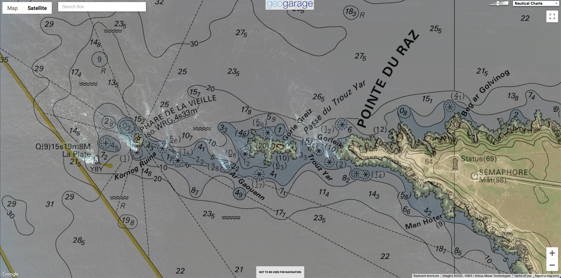
Incredible !!!! A helicopter avoided the crash this Wednesday, July 6, 2022 over the lighthouse of La Vieille at the Pointe du Raz. The video was captured by the webcam of Audierne Info installed on the semaphore of the Pointe du Raz. It was a maintenance operation on the Vieille lighthouse by the lighthouse and beacon personnel.
Localization with the GeoGarage platform (Shom nautical raster chart)
This maintenance work on the Vieille lighthouse is supervised by the Interregional Directorate of the North Atlantic Channel Sea (Dir Namo) and carried out by the Lighthouse and Beacon Service (Phares et Balises)
The accident occurred when the helicopter was removing one of the frames of the lighthouse's lantern. The helicopter lifted the load vertically, became unbalanced and the pilot lost control.
The helicopter pilot performed a desperate maneuver a few meters from the surface of the sea.
This opened the airbags of the helicopter and caused a thick smoke. The experienced pilot of the company Mont Blanc Hélicoptères Bretagne based in Vannes left the area