Saturday, June 20, 2020

New Zealand (Linz) layer updated in the GeoGarage platform

18 nautical raster charts updated

Breathing the ocean

Take a deep breath.
In "Breathing the Ocean", a short film in which she raises her voice, Julie Gautier raises the question of the essential role of phytoplankton in the planetary ecosystem.
After "Into The Depths", a film that raises awareness of the pollution of the aquatic ecosystem, the Biotherm skincare brand wanted to put the spotlight on the importance of plant plankton by featuring the famous film director, freediver and dancer from Reunion Island.
Forests play an essential role in the well-being of the planet, but it is the phytoplankton that are considered a true blue lung.

In fact, more than half of the oxygen produced on Earth comes from these plant organisms living in suspension in the water.
And if it is too small to be seen with the naked eye, large, colourful expanses of phytoplankton can be seen on the surface of the water when they congregate in sufficient numbers and emit light.
A phenomenon that testifies to the immensity of the subject, as Julie Gautier reminds us:
"So small you can't see it, so big you can't imagine it."
"It's simply because of them that we can breathe."
 And if the directors wanted to raise awareness about the beauty and importance of the links between climate and plant plankton, it is because they are in danger.
Threatened by plastic pollution of the oceans, climate change and environmental upheavals, the quantity of phytoplankton is decreasing by 1% every year and 40% have even disappeared since 1950.
Then yes, art can be engaged.

Friday, June 19, 2020

Cuba (GeoCuba) layer update in the GeoGarage platform

11 nautical raster charts updated

A satellite lets scientists see Antarctica’s melting like never before

Sources: NASA ICESat and ICESat-2

From NYTimes by Kendra Pierre-Louis, Henry Fountain and Denise Lu

New data from space is providing the most precise picture yet of Antarctica’s ice, where it is accumulating most quickly and disappearing at the fastest rate, and how the changes could contribute to rising sea levels.

The information, in a paper published on Thursday in the journal Science, will help researchers better understand the largest driver of ice loss in Antarctica, the thinning of floating ice shelves that allows more ice to flow from the interior to the ocean, and how that will contribute to rising sea levels.
Researchers have known for a long time that, while the continent is losing mass over all as the climate changes, the change is uneven.
It is gaining more ice in some areas, like parts of East Antarctica, and losing it quickly in others, in West Antarctica and the Antarctic Peninsula.

Helen A. Fricker, an author of the paper, said that scientists have tried to study the link between thinning shelves and what is called grounded ice, but have been hampered because most observations were of one area or the other, and made at different times.
“Now we’ve got it all on the same map, which is a really powerful thing,” said Dr. Fricker, a glaciologist at the Scripps Institution of Oceanography in La Jolla, Calif.

Using the most advanced Earth-observing laser instrument NASA has ever flown in space, scientists have made precise, detailed measurements of how the elevation of the Greenland and Antarctic ice sheets have changed over 16 years.
The results provide insights into how the polar ice sheets are changing, demonstrating definitively that small gains of ice in East Antarctica are dwarfed by massive losses in West Antarctica.
The scientists found the net loss of ice from Antarctica, along with Greenland’s shrinking ice sheet, has been responsible for 0.55 inches (14 millimeters) of sea level rise between 2003 and 2019 – slightly less than a third of the total amount of sea level rise observed in the world’s oceans.

The Ice, Cloud and land Elevation Satellite-2, or ICESat-2, was launched in 2018 as part of NASA’s Earth Observing System.
It replaced a satellite that had provided data from 2003 to 2009.
ICESat-2 uses a laser altimeter, which fires pulses of photons split into six beams toward the Earth’s surface 300 miles below.
Of the trillions of photons in each pulse, only a handful of reflected ones are detected back at the satellite.
Extremely precise measurement of these photons’ travel times provides surface elevation data that is accurate to within a few inches.

“It’s not like any instrument that we’ve had in space before,” said another of the authors, Alex S. Gardner, a glaciologist at NASA’s Jet Propulsion Laboratory in Pasadena, Calif.
The resolution is so high that it can detect rifts and other small features of the ice surface, he said.


The coast of West Antarctica is rapidly losing mass as warm water melts ice shelves from below and icebergs break off.

The researchers used the elevation measurements from both satellites to determine how Antarctica’s mass balance, the difference between accumulation and loss, changed from 2003 to 2019 for each of its 27 drainage basins.
Over all, they reported that the continent had lost enough ice to raise sea levels by six millimeters, or about one-quarter of an inch, during that time period.

While that finding is consistent with other studies that used data from other instruments, “in a lot of ways this is a more definitive measurement,” said Ben Smith, a glaciologist at the University of Washington and an author of the study.
“It shows a set of differences that we can really understand in detail and know what they mean for the ice sheets.”

Ice loss was limited to West Antarctica and the Antarctic Peninsula; the bigger East Antarctic sheet gained mass over that time.
The East Antarctic increase is likely because of increased precipitation, Dr. Gardner said.
“While we can’t say that these changes are related to contemporary climate change, we can say that these are the patterns of change we expect to see in a warming world,” he said.

Increased precipitation in the form of snow leads to an increase in ice sheet mass because, as snow compresses over time, it turns to ice.


Floating ice shelves accounted for 30 percent of the ice loss in West Antarctica, the researchers found.

Floating ice is lost in two ways: by calving of icebergs and through melting from underneath by a deep current of warmer water that circulates around the continent.

Floating ice is, by definition, already in the water, so when it calves or melts it does not add to sea level rise.
But ice shelves act as buttresses against the grounded ice behind them; when they thin they allow that ice to flow faster.
And when the previously grounded ice reaches the water, it adds to rising seas.

Scientists are increasingly concerned that the loss of floating ice in West Antarctica is causing more rapid flow of grounded ice in the West Antarctic ice sheet, and that a portion of the sheet could collapse over centuries, greatly increasing sea levels.

The study looked at changes in the Greenland ice sheet as well.
Unlike Antarctica, where little ice is lost through surface melting and runoff, as much as two-thirds of Greenland’s ice is lost this way.

Using data from the ICESat and ICESat-2 laser altimeters, scientists precisely measured how much ice has been lost from ice sheets in Antarctica and Greenland between 2003 and 2019.
The Antarctic Peninsula, seen here, was one of the fastest changing regions of the continent.
Credits: NASA / K. Ramsayer

Using their elevation data, the researchers found that Greenland is losing about 200 billion tons of mass each year on average.
That’s enough to raise sea levels by about eight millimeters, or a third of an inch, over the study period.

The mass loss figure is roughly similar to other recent estimates.

The study is the first to be published using data from ICESat-2, which was designed to have an operating life of at least three years.
Many more studies are expected that should add to the understanding of Earth’s frozen expanses.

“Where we’re at in ice sheet science is, there are still a lot of unknowns,” Dr. Gardner said.
One advantage of ICESat-2, he said, is its ability to measure changes in some of the smallest ice sheet features.
That will help scientists better understand how the changes are occurring and improve forecasts of future impacts as the climate continues to shift.

ICESat-2, he said, “reveals the process of change, and without understanding those processes you have no ability to make predictions.”

“It really just gives us this incredibly crisp, unified picture.”

Links :

Thursday, June 18, 2020

Quantum entanglement could take GPS to the next level

University of Arizona engineers have demonstrated how quantum capabilities could improve functions like GPS, medical imaging, astronomy observation and more.

From Futurity by

Quantum entanglement can help detect radio frequencies with more sensitivity and accuracy than ever, researchers report.

Your phone’s GPS, the WiFi in your house, and communications on aircraft are all powered by radio-frequency waves, or RF waves, which carry information from a transmitter at one point to a sensor at another.
The sensors interpret this information in different ways.

For example, a GPS sensor determines its location by using the amount of time it takes to receive a signal from a satellite.
For applications such as in-door localization and defeating spoofing GPS signals, a wireless sensor measures the angle at which it receives an RF wave.
The more precisely the sensor can measure this time delay or angle of arrival, the more it can accurately determine location or enhance security.

In a paper in Physical Review Letters, researchers demonstrate how a combination of two techniques—radio frequency photonics sensing and quantum metrology—can give sensor networks a previously unheard-of level of precision.

The research involves transferring information from electrons to photons, then using quantum entanglement to increase the photons’ sensing capabilities.

“This quantum sensing paradigm could create opportunities to improve GPS systems, astronomy laboratories, and biomedical imaging capabilities,” says Zheshen Zhang, an assistant professor of materials science and engineering and optical sciences, as well principal investigator of the Quantum Information and Materials Group at the University of Arizona.
“It could be used to improve the performance of any application that requires a network of sensors.”

From electrons to light

Traditional antenna sensors transform information from RF signals to an electrical current made up of moving electrons.
However, optical sensing, which uses photons, or units of light, to carry information, is much more efficient.

Not only can photons hold more data than electrons, giving the signal larger bandwidth, but photonics-based sensing can transmit that signal much farther than electronics-based sensing, and with less interference.
Because optical signals offer so many advantages, the researchers used an electro-optical transducer to convert RF waves into the optical domain in a method called RF-photonics sensing.

“We designed a bridge between an optical system and a physical quantity in a completely different domain,” Zhang explains.
“We demonstrated that with an RF domain in this experiment, but the idea could also be applied to other scenarios.
For example, if you want to measure temperature using photons, you could use a thermo-optical transducer to convert the temperature into an optical property.”

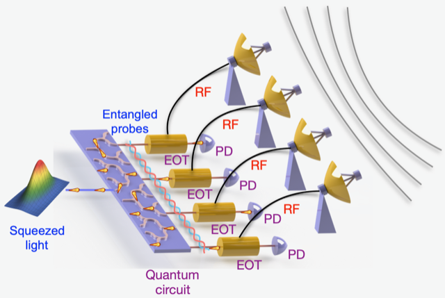
 A graphic demonstrating the team's quantum metrology experiment.

Breaking down quantum entanglement

After converting information to the optical domain, the researchers applied a technique called quantum metrology.

Usually, a sensor’s precision is limited by something called the standard quantum limit.
For example, smartphone GPS systems are usually accurate within a 16-foot radius.
Quantum metrology uses entangled particles to break past the standard quantum limit and take ultrasensitive measurements.

How does it work?
Entangled particles are tied together so anything that happens to one particle affects the particles it’s entangled with as well, as long as appropriate measurements are taken.

Picture a supervisor and an employee working together on a project.
Because it takes time for the employee to share information with his supervisor through methods like emails and meetings, the efficiency of their partnership is limited.
But if the two could entangle their brains together, the employee and the supervisor would automatically have the same information—saving time and allowing them to jointly tackle a common problem more efficiently.

Quantum metrology has been used to improve sensor precision in places like the Laser Interferometer Gravitational-Wave Observatory, or LIGO, which has opened up a new window for astronomers.
However, almost all prior quantum metrology demonstrations, including LIGO, only involve a single sensor.

Networks of sensors

However, RF waves are usually received by a network of sensors, each of which processes information individually—more like a group of independent employees working with their supervisors.
Quntao Zhuang, an assistant professor of electrical and computer engineering, previously demonstrated a theoretical framework to boost performance by teaming up entangled sensors.

This new experiment demonstrates for the first time that researchers can entangle a network of three sensors with one another, meaning they all receive the information from probes and correlate it with one another simultaneously.
It’s more like if a group of employees could share information instantly with their bosses, and the bosses could instantly share that information with each other, making their workflow ultra-efficient.

“Typically, in a complex system—for example, a wireless communications network or even our cellphones—there’s not just a single sensor, but a set of sensors that work together to undertake a task,” Zhang says.

“We’ve developed a technology to entangle these sensors, rather than having them operate individually.
They can use their entanglement to ‘talk’ to each other during the sensing period, which can significantly improve sensing performance.”

While the experiment only used three sensors, it opens the door to the possibility of applying the technique to networks of hundreds of sensors

“Imagine, for example, a network for biological sensing: You can entangle these biosensors so that they work together to identify the species of a biological molecule, or to detect neural activities more precisely than a classical sensor array,” Zhang says.
“Really, this technique could be applied to any application that requires an array or network of sensors.”

In theory work published in Physical Review X in 2019, Zhuang presented how machine learning techniques can train sensors in a large-scale entangled sensor network like this one to take ultra-precise measurements.

“Entanglement allows sensors to more precisely extract features from the parameters being sensed, allowing for better performance in machine learning tasks such as sensor data classification and principal component analysis,” Zhuang says.
“Our previous work provides a theoretical design of an entanglement-enhanced machine learning system that outperforms classical systems.”

Links :

Wednesday, June 17, 2020

Supertrawlers ‘making a mockery’ of UK’s protected seas

The world’s second largest factory fishing trawler, the Lithuanian FV Margiris, was among 25 supertrawlers fishing in protected UK waters.
Photograph: Greenpeace/PA

From The Guardian by Damian Carrington

Supertrawlers spent almost 3,000 hours fishing in UK marine protected areas in 2019, making “a mockery of the word ‘protected’,” according to campaigners.

Supertrawlers are those over 100 metres in length and can catch hundreds of tonnes of fish every day, using nets up to a mile long.
A Greenpeace investigation revealed that the 25 supertrawlers included the four biggest in the world and fished in 39 different marine protected areas (MPAs).

 Annelies LLena supertrawler

The Southern North Sea MPA was one of those fished and was created to safeguard porpoises, which are especially threatened by supertrawlers.
More than 1,000 porpoises died in fishing nets around the UK in 2019.
The most heavily fished MPA was the Wyville Thomson Ridge, off Shetland, which was intended to protect reefs.
All the supertrawler fishing was legal.

 Willem Van Der Zwan tracking

Forty per cent of England’s seas are designated as MPAs, but these only ban some of the most damaging activities in some locations.
On Monday, an independent reviewcommissioned by the government urged the establishment of highly protected marine areas (HPMAs), where all harmful activities including fishing, dredging and construction are banned.
The government’s own assessment in 2019 showed the marine environment is not in a healthy state.

“Our government allowing destructive supertrawlers to fish for thousands of hours every year in MPAs makes a mockery of the word ‘protected’,” said Chris Thorne of Greenpeace UK.
“For our government to be taken seriously as a leader in marine protection, it must ban this practice.”

 Jan Marian supertrawler

Prof Callum Roberts of the University of York, a member of the HPMA review panel, said: “The Greenpeace analysis is timely and important.
It highlights the yawning gulf between what people imagine an MPA is there for, to protect nature and wildlife, and the reality of continued industrial exploitation with little evidence of restraint or oversight.
“A high level of protection is necessary for a high level of benefit,” he said.
“We cannot be surprised if MPAs that are open to some of the most voracious and destructive fishing methods in the world have no measurable benefit at all.
“That is why the [HPMA] review is important. If we are to rescue British waters from two centuries of overfishing and destructive fishing, we will need to roll out HPMAs widely and fast.”


Sea birds follow the German flagged trawler Maartje Theadora as it fishes for herring in the English Channel
(Photo: Christian Aslund / Greenpeace)

Greenpeace used tracking data from the Lloyd’s List to show that trawlers over 100 metres spent 2,963 hours fishing in UK MPAs in 2019.
None of the 25 supertrawlers are British-owned, with 15 Russian-owned, nine Dutch-owned and one Polish-owned.

A spokesman for the Department of Environment, Food and Rural Affairs said: “The UK is a global leader in the fight to protect our seas with our ‘blue belt’ of protected waters nearly twice the size of England.
The common fisheries policy currently restricts our ability to implement tougher protection, but leaving the EU and taking back control of our waters means we can introduce stronger measures.”

Willem Van Der Zwan (142m/9500t) supertrawler

Jean-Luc Solandt of the Marine Conservation Society said: “The government had an opportunity to designate 65 HPMA sites in English waters back in 2013, but failed to do so, citing a ‘lack of evidence’ and bowing to pressure from industry and fishing lobbyists.
The [HPMA report] is promising, but means nothing if the government – after decades of delay – doesn’t get them in place with urgency.”

 SCH24 Afrika (126m/7000t) supertrawler

Joan Edwards, the director of marine conservation at the Wildlife Trusts and another member of the HPMA review panel, said: “Our seas are in an impoverished state. Cod were once as long as humans are tall, and whales, dolphins and basking sharks were many times more common. We want the government to commit to an HPMA delivery plan [within 12 months].”

On Monday, the environment secretary, George Eustice, said: “We will carefully consider the recommendations set out in the review.”

Separately, more than 50 scientists have signed a letter to the European Commission, European parliament and member states calling for an end to overfishing.
Under reforms to the common fisheries policy, fishing quotas in 2020 were supposed to be in line with the maximum sustainable yield, determined by scientific advice.
However, overfishing beyond what scientists regard as safe levels has continued and looks set to carry on into future years, as the UK and the EU wrangle over fishing as part of the Brexit negotiations.

 A Dutch super trawler like the one used in UK waters
(Photo: Pierre Gleizes / Greenpeace)

The scientists warned that further overfishing would harm fish populations and stop them from recovering.

Rainer Froese, of the Helmholtz centre for ocean research in Kiel, Germany, said: “Overfishing means taking more fish out the water than can grow back – that’s pretty stupid.
The stocks shrink, and small stocks can only support small catches.
It doesn’t help the fishermen, it doesn’t help the fish, it doesn’t help anyone.”

Overfishing also harmed the climate, he added: “If the ecosystem does not function properly, it cannot breathe properly and cannot absorb carbon dioxide properly.”

Links :

Tuesday, June 16, 2020

Mechanics of map projections : the myth of Mercator

[OC] 10 map projections and how they distort the world, video 57s. from r/MapPorn

The Mercator projection distorts land mass and gets criticized for that.
I can see why it's still widely used for world maps.
On other projections individual European countries are hard to make out.
When targeting a European audience Mercator makes sense.

Monday, June 15, 2020

Second woman quickly follows first to ocean’s nadir

The submersible Limiting Factor, a two-person craft piloted by Victor Vescovo, after a dive to the deepest known point of the Mariana Trench in the Pacific last year.
Credit...Tamara Stubbs/Atlantic Productions for Discovery Channel, via Associated Press

From NYTimes by William J. Broad

The mountaineer Vanessa O’Brien dove to the Challenger Deep, seven miles below the surface of the sea.
The second of two women has made history by diving to the ocean’s deepest spot: the Challenger Deep, the lowest point of the Mariana Trench, the greatest of the sea’s many recesses.

The long fissure of the western Pacific lies 200 miles southwest of Guam.
The deep’s muddy bottom lies nearly seven miles down in inky darkness under crushing pressure.

 Vanessa O’Brien

“I made it,” Vanessa O’Brien, 55, a star of adventure tourism, tweeted after emerging Friday from the icy abyss.
She called herself the first woman “to Earths highest & lowest points!”

 Kathy Sullivan and Victor Vescovo
Enrique Alvarez / EYOS Expeditions

 Kathy Sullivan becomes US woman to walk in space – NASAachiev

Her moment comes after the plunge on Sunday of Kathy Sullivan, 68, an oceanographer, astronaut and the first American woman to walk in space.

Both women are passengers of Victor L.Vescovo, a wealthy investor who has climbed Mount Everest and last year piloted a mini submarine into the Challenger Deep.

His innovative craft is up for sale, and earlier this year a London firm was selling dives on the expedition for $750,000.

Men who have made the descent include James Cameron, the maker of the “Avatar” and “Titanic” films, who explored the deep in a 2012 dive, and two Navy divers in 1960.
Dr. Sullivan became the eighth person in history to reach the deep’s bottom, and the first woman.

Mr. Vescovo calls his diving venture Caladan Oceanic, after a water-covered planet in the science-fiction saga “Dune.”
His two-person craft features an inner five-foot sphere made of titanium, a superstrong metal, and three portholes the size of dinner plates.
He had it built by Triton Submarines, a company in Sebastian, Fla.
The diving vessel and its mother ship cost $48 million.

In a recent profile, The New Yorker described Mr. Vescovo as part of an elite group of explorers setting the last meaningful records on Earth.
In an email Tuesday, Mr. Vescovo said that Ms. O’Brien was paying for her dive but gave no specific figure.
“Funds she provides will allow me to fund longer science missions in the northern Mariana Trench,” he wrote.
Those dives are planned for July, Mr. Vescovo said.
Mr. Vescovo added that Ms. O’Brien’s financial contribution would help pay not only for her own dive but also for the expedition’s monthlong seabed mapping effort for the National Oceanic and Atmospheric Administration and a project of the International Hydrographic Organization known as the General Bathymetric Chart of the Oceans.

Ms. O’Brien told Forbes in April that she decided to pay for her part of the expedition in lieu of signing up backers, as extreme adventure fans often do.
“It didn’t seem appropriate to try and find sponsors,” she said, at a time when the global coronavirus pandemic had upended so many lives.

Vanessa Audi Rhys O’Brien grew up in Grosse Pointe Farms, Mich., worked for Barclays and Morgan Stanley and is the author of a forthcoming memoir, “To the Greatest Heights.”
The book describes Ms. O’Brien’s fall from the corporate ladder during the 2009 economic downturn and her quest for new meaning in global mountaineering.

In the depths of the global ocean, the line between raw exploration and adventure tourism has long been murky.
In 1985 the deteriorating hulk of the Titanic was discovered some 73 years after the luxury liner, said to be unsinkable, struck an iceberg on its maiden voyage and went down in waters more than two miles deep, resulting in the loss of more than 1,500 lives.

By 2003, scientists warned that visitors in newly capable miniature submarines were endangering the world’s most famous shipwreck.
Assailed by explorers, moviemakers, salvors and tourists — including a couple that was married on its sunken bow — as well as rust and seabed creatures, the iconic liner was described as rapidly falling apart.

It is not uncommon for tourist-dive companies to perform a measure of scientific research as an adjunct to their commercial ambitions.
In an interview last year, Mr. Vescovo said that he saw his own push for deep exploration — including what his team has called the world’s first crewed “expedition to the deepest point in each of the five oceans” — as helping rekindle interest in the planet’s lifeblood.

“Hopefully, it will spur more interest in the ocean and real science,” he said.
“No one has ever been to these places before and measured them. We’d like to continue to see that done. I hope it leads to a renaissance in deep-sea exploration.”

Links :


Sunday, June 14, 2020

Canada (CHS) update in the GeoGarage platform

53 nautical raster charts updated

Hetairos

Hetairos sailing in the 2014 Boat International BVI Regatta