Unlike most people, the children of a Thailand tribe see with total
clarity beneath the waves – how do they do it, and might their talent be
learned?
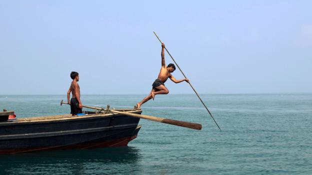
“When the tide came in, these kids started swimming. But not like
I had seen before. They were more underwater than above water, they had
their eyes wide open – they were like little dolphins.”
Deep
in the island archipelagos on the Andaman Sea, and along the west coast
of Thailand live small tribes called the Moken people, also known as
sea-nomads.
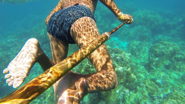
Their children spend much of their day in the sea, diving
for food.
They are uniquely adapted to this job – because they can see
underwater.
And it turns out that with a little practice, their unique
vision might be accessible to any young person.
In 1999, Anna
Gislen at the University of Lund, in Sweden was investigating different
aspects of vision, when a colleague suggested that she might be
interested in studying the unique characteristics of the Moken tribe.
“I’d been sitting in a dark lab for three months, so I thought, ‘yeah,
why not go to Asia instead’,” says Gislen.
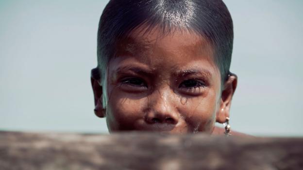
Adults in the tribe lose the ability to see as clearly as the children (Credit: Alamy)
Gislen and her six-year old daughter travelled to Thailand and
integrated themselves within the Moken communities, who mostly lived on
houses sat upon poles.
When the tide came in, the Moken children
splashed around in the water, diving down to pick up food that lay
metres below what Gislen or her daughter could see.
“They had their eyes
wide open, fishing for clams, shells and sea cucumbers, with no problem
at all,” she says.
Gislen set up an experiment
to test just how good the children’s underwater vision really was.
The
kids were excited about joining in, says Gislen, “they thought it was
just a fun game.”
The Moken people live in the island archipelagos on the Andaman Sea, and along the west coast of Thailand (Credit: Alamy)
The kids had to dive underwater and place their heads onto a panel.
From there they could see a card displaying either vertical or
horizontal lines.
Once they had stared at the card, they came back to
the surface to report which direction the lines travelled.
Each time
they dived down, the lines would get thinner, making the task harder.
It
turned out that the Moken children were able to see twice as well as
European children who performed the same experiment at a later date.
What
was going on?
To see clearly above land, you need to be able to refract
light that enters the eye onto the retina.
The retina sits at the back
of the eye and contains specialized cells, which convert the light
signals into electrical signals that the brain interprets as images.
Light
is refracted when it enters the human eye because the outer cornea
contains water, which makes it slightly denser than the air outside the
eye.
An internal lens refracts the light even further.
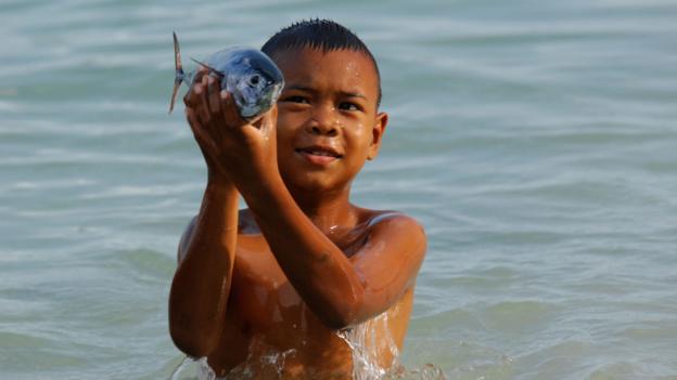
With training, the unique vision of the Moken children might be accessible to any young person (Credit: Alamy)
When the eye is immersed in water, which has about the same density as
the cornea, we lose the refractive power of the cornea, which is why the
image becomes severely blurred.
Gislen figured that in order for the Moken children to see clearly
underwater, they must have either picked up some adaption that
fundamentally changed the way their eyes worked, or they had learned to
use their eyes differently under water.
She thought the first
theory was unlikely, because a fundamental change to the eye would
probably mean the kids wouldn’t be able to see well above water.
A
simple eye test proved this to be true – the Moken children could see
just as well above water as European children of a similar age.
It
had to be some kind of manipulation of the eye itself, thought Gislen.
There are two ways in which you can theoretically improve your vision
underwater.
You can change the shape of the lens – which is called
accommodation – or you can make the pupil smaller, thereby increasing the depth of field.
It's possible the Moken children's eyes are adapted to seawater, avoiding irritation by the salt
(Credit: Alamy)
Their pupil size was easy to measure – and revealed that they can
constrict their pupils to the maximum known limit of human performance.
But this alone couldn’t fully explain the degree to which their sight
improved.
This led Gislen to believe that accommodation of the lens was
also involved.
“We had to make a mathematical calculation to work
out how much the lens was accommodating in order for them to see as far
as they could,” says Gislen.
This showed that the children had to be
able to accommodate to a far greater degree than you would expect to see
underwater.
“Normally when you go underwater, everything is so blurry that the eye
doesn’t even try to accommodate, it’s not a normal reflex,” says Gislen.
“But the Moken children are able to do both – they can make their
pupils smaller and change their lens shape. Seals and dolphins have a
similar adaptation.”
The adults in the tribe catch most of their food by spear fishing above the surface
(Credit: Alamy)
Gislen was able to test a few Moken adults in the same way.
They showed
no unusual underwater vision or accommodation – perhaps explaining why
the adults in the tribe caught most of their food by spear fishing above
the surface.
“When we age, our lenses become less flexible, so it makes
sense that the adults lose the ability to accommodate underwater,” says
Gislen.
Gislen wondered whether the Moken children had a genetic anomaly to
thank for their ability to see underwater or whether it was just down to
practice.
To find out, she asked a group of European children on
holiday in Thailand, and a group of children in Sweden to take part in
training sessions, in which they dived underwater and tried to work out
the direction of lines on a card.
After 11 sessions across one month,
both groups had attained the same underwater acuity as the Moken children.
“It
was different for each child, but at some point their vision would just
suddenly improve,” says Gislen. “I asked them whether they were doing
anything different and they said, ‘No, I can just see better now’.”
The homeland of the Moken people was badly damaged in the 2004 tsunami
(Credit: Alamy)
She did notice, however, that the European kids would experience red
eyes, irritated by the salt in the water, whereas the Moken children
appeared to have no such problem.
“So perhaps there is some adaptation
there that allows them to dive down 30 times without any irritation,”
she says.
Gislen recently returned to Thailand to visit the Moken
tribes, but things had changed dramatically.
In 2004, a tsunami created
by a giant earthquake within the Indian Ocean destroyed much of the
Moken’s homeland.
The Surin Islands, 60 kilometres from mainland Thailand, have gone from paradise to prison for the Moken people.
Since the Surin National Park in Phang Nga province was established in 1981, their nomadic patterns, foraging and logging activities have suffered and their culture may soon be a thing of the past, but that's only half the problem. Moken children aren't counted as Thai citizens.
They are often isolated due to their physical location and excluded from mainstream society, unreached by basic services.
Plan Thailand works on Indigenous and Isolated Children in Phang Nga and Ranong to support the Moken children and improve their quality of life. The nomadic culture of the Moken is about 1,000 years old, long enough for them to develop their own distinctive language and culture.
Many aspects of Moken culture have already changed as the culture has gradually moved away from the ocean.
Since then, the Thai government has worked hard to
move them onto the land, building homes that are further inland and
employing members of the tribe to work in the National Park.
“It’s
difficult,” says Gislen.
“You want to help keep people safe and give
them the best parts of modern culture, but in doing so they lose their
own culture.”
In February 2014, Ian Donald, Freedive UK and Project Moken took a group of western freedivers, by invitation, to live and freedive with the last remaining tribe of Moken sea nomads in Thailand.
A tribe who's freediving history and skills date back thousands of years, and are able to dive up to 30m deep with no fins, masks or weight.
A freediving history so long that they are genetically pre-disposed to apnea. The objective of the trip was to learn more about the problems that the Moken face in the modern world, to help them re-engage with their freediving heritage and to learn about the techniques that they use as freedivers.
In unpublished work, Gislen tested the same kids
that were in her original experiment.
The Moken children, now in their
late teens, were still able to see clearly underwater.
She wasn’t able
to test many adults as they were too shy, but she is certain that they
would have lost the ability to see underwater as they got older.
“The
adult eye just isn’t capable of that amount of accommodation,” she says.
Unfortunately,
the children in Gislen’s experiments may be the last of the tribe to
possess the ability to see so clearly underwater.
“They just don’t spend
as much time in the sea anymore,” she says, “so I doubt that any of the
children that grow up these days in the tribe have this extraordinary
vision.”
Piracy these days generally refers to software, but Verizon has unearthed a case of real-life pirates actually conducting the act in order to raid a number of ships.
The group of pirates hacked into a shipping company’s content
management system and managed to acquire confidential information on
schedules and cargo aboard different vessels.
The report (➤ Data Breach Digest [Verizon]) explains:
Rather than spending days holding boats and their
crew hostage while they rummaged through the cargo, these pirates began
to attack shipping vessels in an extremely targeted and timely fashion.Specifically, they would board a shipping vessel, force the crew into
one area and within a short amount of time they would depart. When crews
eventually left their safe rooms hours later, it was to find that the
pirates had headed straight for certain cargo containers.
While the situation is worrying for shipping companies, there is a
silver lining – the report concluded that the group were indeed creative
but not the most skilled hackers.
They failed to enable SSL on the web shell and sent their commands in
plain text, which in turn allowed the shipping company to write a code
to remove them relatively easily.
The report also states that they
discovered numerous mistyped commands.
The shipping company successfully managed to implement a reverse
shell and curb any further attempts at hacking by the pirates, which did
happen.
The report claims they saw the pirates spending a lot of time trying
to get around their newly-secured CMS (Content Management System), which ultimately proved to be
unsuccessful.
The pirates also appear to have not used a proxy during
these attempts from their home systems, which is just a rookie mistake.
The report reads, “These threat actors, while given points for creativity, were clearly not highly skilled. For instance, we found numerous mistyped commands and observed the threat actors constantly struggled with the compromised servers.”
“We then honed in on the network traffic surrounding the CMS managing shipping routes,” said Verizon RISK Team.
“We discovered that a malicious web shell had been uploaded onto the server.” Web shells can compromise legitimate web apps on a server.
“The threat actors used an insecure upload script to upload the web shell and then directly call it as this directory was web accessible,” noted Verizon RISK Team.
“Essentially, this allowed the threat actors to interact with the webserver and perform actions such as uploading and downloading data, as well as running various commands.”
Chillingly, the hackers were able to pull down documents for future shipments, identify specific crates and the vessels scheduled to carry them.
Verizon RISK Team did not reveal specific details of how it tackled the hackers but said that it capitalized on “several mistakes” made by the high-tech pirates. The report did not reveal the location of the incidents or when they happened, although there been frequent attacks by Somali pirates on commercial shipping off Africa’s east coast in recent years.
And these modern day pirates seemed to know exactly where to find their loot.
“When crews eventually left their safe rooms hours later, it was to find that the pirates had headed straight for certain cargo containers,” the report added.
“It became apparent to the shipping company that the pirates had specific knowledge of the contents of each of the shipping crates being moved.”
So how did these pirates of the high seas know exactly what ships to invade and where to go once they had gotten onboard and taken the crew hostage?
“They’d board a vessel, locate by bar code specific sought-after crates containing valuables, steal the contents of that crate—and that crate only—and then depart the vessel without further incident,” the report said
“Fast, clean and easy.” According to Verizon, the pirates-turned-hackers found a way to see merchandise details in the records carriers release — and to see which vessels were scheduled to carry it.
Verizon described the hack in its annual data breach postmortem released Tuesday.
(For a more technical explanation of their attack, see page 55 of the report.)
So they helped the shipping company shut down severs the pirates had compromised and build a security plan.
While pirates aren’t a new nuisance in the maritime world, this
attack shows that they are becoming more and more advanced in their
techniques, even if these ones were a little rough around the edges.
Not so long ago, the Ukraine experienced the world’s first blackout caused by hackers after an attack on its regional power authorities left the systems infected with malware.
This is an example of yet another industry that has inadvertently
left itself open to hacking.
A pirate that’s armed with both ammunition
and hacking skills is not something that all industries are ready to
face.
The map shows the location of the Joint Petroleum Development Area (JPDA) within the Timor Sea between Australia and Timor-Leste.
It also marks the 1972 Australia-Indonesia Seabed Boundary and Timor Trough.
The Bayu/Undan, Elang and Jahal oil and gas fields lie within the JPDA.
The Greater Sunrise Unit Area lies partly within the JPDA and partly in Australian seabed jurisdiction to the east of the JPDA and south of the 1972 Australia-Indonesia Seabed Boundary.
The shadow foreign minister's proposal to take the Timor maritime
boundary to international arbitration if an agreement cannot be reached
has triggered an interesting Interpreter discussion here (with five comments), here and here.
There is still a wide range of opinion on this complex and vexed topic,
but it should be possible to clear away some of the more obvious
misunderstandings and set out the issues which need to be settled
between competing judgments.
First, many of the simplistic statements are wrong (e.g.
Tom Allard
'If the boundary was drawn midway between East Timor and Australia — as
is standard under international law — most of the oil and gas reserves
would lie within Timor's territory.').
If the east-west border were to be drawn at equidistance, it would,
in effect, give Timor the Joint Petroleum Development Area (JPDA).
This
would mean that instead of getting 90% of the current revenue, Timor
would receive 100%.
But this would also mean that, when Greater Sunrise
comes on stream, Timor would receive around 20% of its revenue, instead
of the 50% agreed in the 2006 CMATS treaty.
As Sunrise has not yet been
developed, it's not possible to know exactly what this means in terms
of revenue, but Sunrise is usually said to be 2-3 times as big as Bayu
Undan, the main resource within the JPDA.
Thus if drawing this border at
equidistance was the only change, Timor would gain a further 10% of
current production in the JPDA and lose 30% of Sunrise's potential
revenue.
In total, very likely to be less than under CMATS.
Of course there is much, much more.
Timor doesn't just want to draw
an equidistant east-west boundary; it wants to shift the 'laterals' (the
sides of the JPDA), extending the yellow area down to the median line
on this La'o Hamutuk chart here.
The JPDA laterals were drawn as 'simplified equidistance' from
Indonesia and Timor.
'Equidistance' is not so straightforward with the
laterals, and widening them would almost certainly involves Indonesia,
if only because this would encroach on Indonesia's Exclusive Economic
Zone (EEZ) covering the water column (but not the seabed).
This was set
down in the 1997 agreement with Australia that is signed but not
ratified, although this EEZ is recognised as a practical matter (e.g.
for fishing supervision) and on maritime charts.
But if we ignore the problem of the EEZ for the moment, and focus
just on the geography of 'equidistance', my amateur reading is that the
closest we have to an objective expert assessment on the exact geography
is here,
which sets out clearly the alternative ways of drawing the laterals,
including those claimed by Timor and those discussed in the 'Lowe opinion'
(put forward by Petrotimor, an American company which had been given
exploration rights in the disputed area by the Portuguese authorities in
1974).
Among the numerous permutations shown, all except the Timorese
claim and the Lowe opinion cluster around the existing laterals (see
Charts 34-41).
The Lowe opinion actually gives rather modest support to shifting the
laterals.
It explores the idea of modifying the current Indonesian
baselines for the purpose of drawing the laterals, so as to diminish the
importance of some sparsely-populated Indonesian islands and to draw
the laterals on the basis of 'opposite coastlines' rather than
equidistance based on the locus of points equidistant from the closest
point on the baselines.
The effect is to create an eastern lateral which
puts most of Sunrise in Timor territory (see Charts 17-19), even though
the bulk of Sunrise is indisputably closer to Indonesia than it is to
Timor.
This is clever advocacy, but in the end the Lowe opinion accepts
that 'the JPDA is the area to which we consider that East Timor has a
good legal claim at present'.
If this wasn't complicated enough, another argument (see Bernard Collaery's comment here)
is that because Timor and Indonesian territories form a concave arc, an
equidistant lateral border would give less marine boundary to Timor
than it would have if the two countries lay on a straight line and the
lateral was drawn perpendicular to this straight line (the 'pinch-in'
effect).
But of course Indonesia could make exactly the same argument to
justify swinging the border more to the west.
Second, what about the equally vexed issue of the continental shelf
It is certainly not true that UNCLOS fixes borders on the basis of
equidistance rather than the continental shelf.
In fact the 11 articles
of Part VI of UNCLOS specifically address the continental shelf and its 'natural prolongation'
beyond 200 nautical miles.
As for the specific application to
Australia, to argue — as Michael Leach does — that 'Timor-Leste stands
as the sole exception' to equidistance is wrong, as a glance at this
chart will show:
Since 1953 or earlier, Australia has based its maritime borders on
the continental shelf.
The vast majority of Australia's boundaries are
drawn this way, and all these have been specifically endorsed by UNCLOS'
Commission on the Limits of the Continental Shelf.
The exceptions are
where our continental shelf extends to the shelf of a neighbouring
country, where the border is drawn on the basis of equidistance.
There is, of course, one notable precedent where the continental
shelf over-rode equidistance, and that is the 1972 treaty with
Indonesia.
Even here, equidistance played a role, with more than 500km
of the border (essentially the area adjacent to Irian) being based on
equidistance.
Third, let's look at what UNCLOS actually says.
Article 15 has the only mention of 'equidistance':
Where the coasts of two States are opposite or adjacent to each
other, neither of the two States is entitled, failing agreement between
them to the contrary, to extend its territorial sea beyond the median
line every point of which is equidistant from the nearest points on the
baselines from which the breadth of the territorial seas of each of the
two States is measured.
The above provision does not apply, however,
where it is necessary by reason of historic title or other special
circumstances to delimit the territorial seas of the two States in a way
which is at variance therewith.
Article 84 specifically addresses the case of the continental shelf.
In part, it says:
The delimitation of the continental shelf between States with
opposite or adjacent coasts shall be effected by agreement on the basis
of international law, as referred to in Article 38 of the Statute of the
International Court of Justice, in order to achieve an equitable
solution.
Not much help to either side here; there is no mention of
'equidistance'.
The first priority is to reach agreement, and if this
can't be done, then it has to be sorted out by international dispute
settlement.
Thus it is in dispute settlement, outside UNCLOS itself,
that these issues have been adjudicated.
Through that process in recent decades the continental shelf has lost
ground to the equidistance principle, largely because in almost all
cases the continental shelf is shared by the countries in dispute.
Rather than adjudicate on the esoteric geological advice (which seems to
be able to support any position), the courts have in effect taken the
easy way out and decided on the basis of equidistance, sometimes with
some attempt to take account of whatever 'equitable' means.
So how is a dispute likely to go if put to the international courts, as Labor is offering?
Because the over-riding principle in UNCLOS is 'equitable', the
outcome could be anywhere.
But we might be able to narrow it down a bit.
On the east-west boundary, it is likely that 'equidistance' would
prevail, despite the fact that the Timor Trench is well defined and is
2-3 kilometers deep.
On the laterals, there might be minor refinement,
but the existing ones are so close to Article 15's 'equidistant from the
nearest points on the baseline' that it's hard to see any of the Lowe
arguments or the 'pinch-in' argument gaining traction.
To shift the
laterals so that Sunrise is largely in Timorese territory would infringe
UNCLOS' central 'equidistant' principle, as the bulk of Sunrise is
indisputably closer to Indonesia than it is to Timor.
Shifting the
laterals would also encroach onto Indonesia's agreed EEZ (which just
applies to the seabed water column*, but would be an endorsement of the separation of seabed and EEZ, which arbitrators will be reluctant to do).
How would this leave the various parties?
Michael Leach is too optimistic when he says: 'There is little
question that a negotiated settlement of maritime boundaries, if it
reflected median line principles, would remove the major irritant in the
relationship for good'.
Timor would have lost what it considers to be
its birthright — widened laterals including Sunrise.
It might not even
get the whole of the JPDA (see the discussion in the Lowe opinion).
Even
if it did, it would almost certainly have less revenue from the known
resources, and would have little leverage to get Sunrise gas piped to
Timor, for the much-hoped-for LNG industry on Timor's southern coast.
Indonesia would be very unhappy with a much more favourable border
adjacent to theirs.
Mochtar Kusumaatmadja, Indonesia's highly-regarded
former foreign minister, who was closely involved in the 1972 treaty,
says 'they were taken to the cleaners'.
If Timor did succeed in having
the laterals shifted, Indonesia would be angrier still.
It has plenty of
ways to make things more difficult for either Timor or Australia, or
both.
As for Australia, just as many Australians might be surprised to know
that we don't yet have a maritime border with Timor, they might be even
more surprised to learn that getting such a border settlement involves
giving up part of the continental shelf, which they may have thought
belonged to us.
Let's see whether the groundswell of public support for
Timor's position remains as strong when the press headline is: 'Labor
offers to give away our continental shelf'.
I'll address two related issues in a later (shorter, I promise!) post: on the virtues of 'rules-based international order' and the shameful ASIS spying on Timor.
A Black Fish citizen inspector on the north coast of Sicily.
Photograph: Kukka Ranta
From The Guardian by Matthew Green Illegal fishing controlled by organised crime is a growing menace, offering big rewards for low risk. But the seaborne raiders have a new force to contend with. An army of amateur sleuths are spending their holidays fighting back
On 2 August, a flotilla of white-hulled fishing boats assembled in Sant’Agata di Militello, a port in northern Sicily, in the late afternoon sun.
As a brass band played, a holiday crowd gathered along the quay.
A float bearing a statue of the Virgin Mary, crowned with a halo of gold and decorated with white flowers, was loaded onto one of the craft.
With the priest and the brass band on board, the vessel, decked out in palm fronds, puttered out into the bay.
As the Madonna was borne over the waves in the annual ritual to bless the sea’s harvest, onlookers crowded onto the other boats, which began to follow in the vessel’s wake, their lights winking on in the dusk.
Sant’Agata di Militello, a port in northern Sicily (GeoGarage / NGA chart)
While the crowd’s eyes were fixed on the Madonna, a clean-cut, compactly-built man with neat blond hair joined the melee and crossed a gangplank onto one of the boats.
As the skipper cast off, his craft now filled with revellers, the blond man slipped below deck, unseen.
The stowaway, a Dutchman named Wietse van der Werf, was a former ship’s engineer and knew his way around boats.
He soon found what he was looking for: an orange nylon driftnet neatly folded under a tarpaulin.
Known as “curtains of death” for the indiscriminate destruction they visit on whales, seabirds, dolphins and sharks, such nets – which can be 20km long and the height of a 10-storey building – are subject to strict international controls.
As guests on deck watched fireworks bursting above the bay, Van der Werf filmed the driftnet on his phone.
When the fireworks above Sant’Agata faded, the flotilla returned to the harbour, illuminated by the glare of sodium lights.
Waiting until the guests had disembarked, Van der Werf casually took a picture of another driftnet piled on the aft deck, gave the captain a friendly nod, then hopped ashore.
Relieved to have escaped undetected, he drove back to the “safe house” – a nondescript apartment he had rented in a seaside village 20km down the coast – and downloaded the images onto his laptop.
With his faintly bookish air, Van der Werf would more easily pass as the founder of a disruptive online startup than an undercover detective.
Nevertheless, his clandestine trip was just the kind of amateur sleuthing he sees as key to defeating a growing threat: the lucrative illegal fishing industry supported by organized crime.
Where once crime syndicates focused on more familiar black market commodities – cocaine or heroin; arms; smuggled crude oil; trafficked women – law enforcement officials say that cartels are discovering opportunities in the more innocuous-sounding world of fisheries.
In 2013 Interpol launched Project Scale, an initiative to coordinate the fight against transnational fisheries crime, estimated to be worth up to $23bn a year.
The offenses vary widely – from flouting international rules designed to protect fragile stocks in the northern hemisphere, to the trawling of nominally protected but barely policed waters in some parts of the south.
It is an appealing proposition for criminal gangs: illicit catches can command enormous sums of money and there is very little risk of being caught
“Sometimes I think I’d like to make an advert of police munching doughnuts as an old lady gets robbed right in front of them,” Van der Werf told me.
“That’s the reality in our oceans every day: crimes are committed and the police are not doing anything.”
The more endangered the species, the higher the price.
In Italy, prosecutors suspect the mafia is involved in the trade in illegally caught Atlantic bluefin tuna: magnificent, half-tonne predators fished in the Mediterranean since Roman times.
Drug-smuggling gangs have muscled in on the illicit trade in Russian caviar, eggs laid by leatherback sea turtles on Costa Rican beaches, and South Africa’s harvest of abalone, a sea snail considered a delicacy in parts of south-east Asia.
In Scotland, police say eastern European gangs are using live cables to electrocute razor clams, scooping up daily catches worth £65,000.
These are sophisticated criminals.
“They have legal advice, they have accountancy advice, they’ve got enough money to bribe people,” says Alistair McDonnell, an Interpol criminal intelligence officer who runs Project Scale.
“There are significant business models where the criminal benefits are in the hundreds of millions of dollars – you don’t do that in your garden shed.”
The illegal activity is piling additional pressure on oceans already suffering from rapacious but perfectly legal industrial fishing.
Last year, the World Wildlife Fund published a report showing that the population of fish species exploited by humans has fallen by half since 1970.
In January, another study suggested that the extent of overfishing was even worse than marine biologists had feared.
Produced jointly by more than 50 institutions around the world, the report found the global catch peaked at 130m tonnes in 1996 and has declined sharply ever since – on average by about 1.2m tonnes every year.
Disappointingly, the fall was not a result of better regulation, but a sign that fish are becoming scarcer.
The findings formed a grim backdrop to a high-level EU seminar on the deteriorating situation in the Mediterranean, held in the Sicilian city of Catania in early February.
“The more scientific knowledge we get for the state of the Mediterranean, the bleaker the picture gets,” said Karmenu Vella, European commissioner for the environment, maritime affairs and fisheries.
In Italy, prosecutors suspect the mafia is involved in the trade in illegally caught Atlantic bluefin tuna
Van der Werf believes he has an answer.
After several years spent with ecowarriors pursuing Japanese whalers in the Antarctic, he returned to Amsterdam in 2010 and founded his own organisation to document illegal fishing, using startup funds that consisted of a €350 loan from his mother.
He named his new movement the Black Fish – after the term used for contraband catches.
The organisation, which is effectively a self-appointed maritime intelligence agency, has expanded rapidly across Europe.
These days, Van der Werf leads teams working incognito from north Africa and the Baltic to southern Italy and the estuaries of the Cumbrian coast.
The core of self‑taught investigators include a human rights lawyer, a nurse, a forensic scientist, a postman and a train driver on the London Underground.
Last summer, in Sicily, Van der Werf launched the most important and riskiest part of his strategy: deploying the vanguard of a much larger, Europe-wide army of volunteers trained to stake out beaches, fish markets and ports while posing as tourists.
The team, known as the Citizen Inspector Network, is expected to double in number this year to 150, forming what the Black Fish describes as the world’s largest volunteer fisheries monitoring group.
“If we want to strengthen maritime security around illegal fishing, it actually isn’t about bringing in the world’s big guns and navies,” Van der Werf told me.
“The reality is that it’s an odd, eclectic group of people that is going to think strategically and deliver.”
Though Van der Werf spent his formative years engaged in more confrontational forms of activism, he is convinced the future lies in helping to enforce the law – not in breaking it.
(Although he does not object to a little minor trespassing.)
The citizen inspectors – or “CIs”, as the Black Fish call them – are positioning themselves as allies of Europe’s underfunded and overstretched coastguards, hoping that their watchful presence will allow maritime authorities to go after the rule-breakers far more aggressively.
Van der Werf’s volunteers are united by one goal: to gather enough evidence to identify fishermen using illegal gear, and build a detailed enough picture to put the men behind organised fisheries crime in jail.
Natalie, a 24-year-old marine biology undergraduate from Ramsgate, began her journey to Sant’Agata last April, in the greyer environs of Grimsby – a port on England’s east coast.
Once home to the world’s mightiest fishing fleet, the town has never recovered from Iceland’s decision to close its rich fishing grounds to British trawlers in the 1970s.
Today Grimsby has one of the highest rates of youth unemployment in the country.
Wrapped up against the chill of a dreary Saturday afternoon, Natalie surveyed the near-deserted docks with scant enthusiasm, her gaze lingering on the hulk of a derelict ice factory, its roof gaping with holes.
It was day three of a four-day training course Van der Werf and his team were holding in a Quaker meeting house in Nottingham, and the 16-strong class had made the two-hour drive to Grimsby to conduct a mock inspection.
(To protect the identities of its volunteers, the Black Fish requested that they be identified only by their first names or the pseudonyms they use on operations.)
“What’s your feeling when you drive around here?”
Van der Werf asked a pair of women volunteers as their car passed slowly along a quay.
“Well it’s dead,” said one.
“To be honest,” another nodded.
“Very good,” agreed Van der Werf, who has a way of greeting both good news and bad with the same mild yet somehow cryptic expression.
“That’s the thing about observation – you see things where you least expect them.”
The Grimsby trip aimed to overcome any lurking reticence about poking around uninvited in forbidding-looking ports.
In the classroom, volunteers had learned to tell the difference between demersal and pelagic fish species, and to distinguish longlines and open purse seines from gillnets and trolling lines.
They had also been taught to record observations with the Open Data Kit, an open-source app that makes it easy to collate field notes, photographs and geolocation data.
When the group reconvened in an empty car park, Natalie described how her team of young women had teased detailed information out of a fishmonger about his (legal) trade in dogfish.
“We were super playing dumb,” she said, with a conspiratorial smile.
“We said that we were doing an Open University course in creative writing.”
The consensus among volunteers was that a few white lies were justified by the larger goal of fighting fisheries crime.
“That’s what I’m hoping for: to be able to do something,” said Jan, an American volunteer and keen diver, who had travelled from the US for the course.
“I’d like there to be a few fish left when I’m teaching my grandchildren how to dive.”
Van der Werf has been able to marshal such dedication, in large part, because of his own lifelong commitment to high-risk activism.
Growing up in the Netherlands, he began fighting on behalf of animals at the age of eight, when he and a school friend discovered the mangled remains of ducks decapitated by a farmer at a pond.
They returned after school and threw stones through the farmhouse windows.
As a teenager, Van der Werf joined Dutch activists taking direct action to protect woodland – chaining himself to diggers or spending days occupying a crane armed only with rations and a walkie-talkie.
He became a vegan and went on to study violin-making in Newark-on-Trent, a town in England’s Midlands, while working part-time as a bus driver.
In 2008, aged 25, he worked with Paul Watson’s Sea Shepherd Conservation Society, joining the crew of the Steve Irwin, Sea Shepherd’s flagship vessel, working as a carpenter and engineer on operations to intercept Japanese whalers.
The Sea Shepherd missions were intense.
The crew used aggressive tactics against the whalers: they would hurl foul-smelling liquid to render decks unusable; attempt to entangle propellers; blast them with water cannon or recordings of Wagner’s Ride of the Valkyries, and, in some cases, board the Japanese ships.
Van der Werf would toil in a maze of pipes, hissing pressure gauges and churning crank shafts to keep temperamental engines humming, before emerging, caked in oil, to grab some sleep before the next eight-hour shift.
In the ferocious, otherworldly reaches of the Southern Ocean, waves could reach 20m in height and Van der Werf once felt a wall of water throw the ship’s 194-foot hull clean through the air.
His experience with Sea Shepherd showed Van der Werf how determined citizens could cooperate to enforce international laws that protected threatened species, and the early years of the Black Fish reflected something of Sea Shepherd’s swashbuckling spirit.
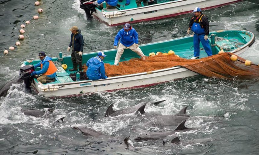
In September, 2010, Van der Werf organised an audacious operation to free dolphins at Taiji in Japan.
The town is renowned for an annual hunt in which fishing boats drive dolphin pods into a cove and the sea turns red during the ensuing slaughter.
Van der Werf dispatched divers who swam through rough seas in darkness to cut through six holding pens, freeing a number of dolphins awaiting sale to theme parks.
Two years later, the Black Fish staged an equally daring night raid on a heavily protected fish farm off the coast of Croatia.
As guard dinghies slalomed under watchtowers, illuminating the surface with searchlights, divers sliced through a huge wire net to release hundreds of juvenile tuna being fattened for sale in Japan.
George Monbiot, the Guardian environment commentator, hailed the operation in a column describing the Black Fish as “heroes”.
The annual dolphin hunt in Taiji, Japan.
Photograph: Sea Shepherd/EPA
The idea of transforming the group from a hard core of plucky vigilantes into a much larger network of part-time citizen inspectors sprang from an unexpected source.
Visiting the Royal Air Force Museum at the old Hendon Aerodrome in north London in the autumn of 2013, Van der Werf learned about the work of the Royal Observer Corps, uniformed volunteers whose patient hours spent scanning the sky for German planes played a vital role in the Battle of Britain.
He envisaged a similar force fanning across the globe to spot rogue trawlers, but using the latest innovations – from selfie-sticks, perfect for snapping surreptitious photos, to cameras mounted on quadrocopter drones.
“If you really want to change things, beyond Facebook posts to like and share, it’s important to get out of your comfort zone,” said Van der Werf, who speaks with a soft Dutch accent.
“My generation is in a way spoilt and we’ve forgotten what it means to make personal sacrifices for a larger cause – but that’s also where life really begins.”
Last year, the Black Fish raised just over a third of its annual revenue of £91,838 from crowdfunding and community events.
Van der Werf’s initiative has also attracted some major donors, including Niklas Zennström, the Swedish tech entrepreneur who founded Skype, and the late Doug Tompkins, the renowned US conservationist and cofounder of outdoor clothing companies the North Face and Esprit.
Van der Werf is confident he will soon raise enough money to launch a 75ft steel-hulled expedition sailing vessel to start maritime patrols.
In December, Project 0, a US-based fundraising group dedicated to ocean conservation, hosted a benefit concert in London, where Van der Werf met Ronnie Wood, the Rolling Stones guitarist, and the model Cara Delevingne. Michele Clarke, Project 0’s founder, said she was backing the Black Fish because of Van der Werf’s ability to mobilise.
“It’s not a concept on a blackboard, he’s actually doing it,” Clarke said. “You’re providing bodies on the ground.”
The clarity of Van der Werf’s mission seems to work as a magnet for volunteers. Young women seem particularly enthusiastic – 85% of CIs are women between the ages of 25 and 35, eager for the opportunity to participate in evidence-gathering without having to adopt the precarious lifestyle of a full-time environmental activist.
The plan is to broaden the support base even further, harnessing the energies of people who might not necessarily be exercised about the fate of the Patagonian toothfish, but who are keen to harness their expertise in novel ways.
Animators have produced films promoting the Black Fish in story form, and several retired security officials are quietly providing advice on best practice for investigations and the training curriculum for CIs.
“Will we be able to protect the oceans fully?
Van der Werf said, speaking at the Black Cat, a vegan cafe in Hackney, in December, 2014, where he was about to address a packed audience of young Londoners – one of 30 or so lectures he gives each year in Europe and the US.
“No, we won’t. Will we be able to save certain species? I hope so.”
Among the images he showed was a photo of a freshly caught shark, its mouth gaping in a silent scream.
“This is about ordinary people taking on organised crime.”
An elegantly curved sea wall protects the harbour at Sant’Agata, where sleek catamarans, speedboats and pleasure craft shelter in a marina next to the quay, which is reserved for trawlers. Natalie would come to know this expanse of concrete well.
Having flown to Sicily on 21 July, 2015 – three months after completing the training in Nottingham – she paired up with Maya, a business executive of Canadian-Lebanese origin, to form Bravo Team, and they began patrolling the heat-rippling docks in twice-daily, three‑hour shifts.
The co-founder of The Black Fish, Wietse van der Werf, explains about the organisation's campaign to end the illegal use of driftnets in the Mediterranean Sea.
The Black Fish had not chosen Sant’Agata by chance.
In the late 1980s, Italy had one of the largest driftnet fleets in the world – some 700 boats trawling for swordfish.
Though the UN and EU have severely curtailed the use of driftnets in a series of rulings since the early 1990s, there have been numerous accounts of their continued use by Sicilian fishermen openly defying the rules or exploiting loopholes in Italian law.
The Sicily mission would be crucial for another reason.
The previous November, Van der Werf had signed an agreement with the regional coastguard commander in the Sicilian port of Messina, outlining the terms of a pilot project in which officers would consider evidence gathered by the Black Fish.
If the pilot was deemed a success, it could be replicated elsewhere in Italy – a big boost to Van der Werf’s aspiration to deploy CIs across Europe and beyond.
After reconnoitring a string of Sicilian ports, volunteers had settled on Sant’Agata as the most promising target.
Serving as intelligence officer for the operation, Van der Werf choreographed the CIs from the safe house, dispatching the first teams at 3.30am to watch the docks in the pre-dawn darkness.
At first, very little seemed to happen on the quay.
But on Maya and Natalie’s second afternoon, they spotted a group of men loading a large net – which looked as if it might be a banned driftnet – onto one of the boats.
Natalie’s first instinct was to start filming with her phone from her vantage point 40 metres away, but unlike some of the friendlier crew the pair had met, these men shot Bravo Team hard glances.
Returning to the safe house, she and Maya gathered around the kitchen table for a debrief with Van der Werf, who was wearing a T-shirt, shorts and flip-flops and poring over a laptop.
“That would have been one thing to document,” he said, his tone even as he typed.
“They were different people,” Natalie protested.
“They were not friendly, and they were looking at us the whole time.”
“That is the most crucial moment – that’s prioritised over everything else,” Van der Werf replied. “Unless you take an image of it or record it, it’s something that didn’t happen.”
The rebuke hung in the air, but as days went by in the safe house, where CIs slept on sofa beds, shared rooms and subsisted on a vegan diet heavy on tomato, pasta and aubergine, it was notable how rarely tempers flared.
After one early morning stakeout, I chatted with Natalie at an espresso bar on the seafront in Santa’Agata.
Like the other CIs, she had fulfilled a requirement that volunteers crowdfund £350 towards their costs.
She had discovered her love of the ocean while learning to dive in Scottish lochs and was more than willing to sacrifice her holiday time if it meant she could make a contribution to collecting evidence.
“You’re always striving for that absolute golden moment when you’re catching something perfect – but it’s a very slow process,” she said. “It’s not going to happen in five minutes of fame.”
It took four consecutive days of inspections before two other CIs – working under the call sign Alpha Team – scored the first breakthrough.
Dave, a 36-year-old pub manager from Sheffield, and Laura, 33, a PhD candidate and freelance journalist from Finland, were making their usual afternoon sweep posing as a couple, strolling arm-in-arm past the boats.
Dave, who wore camouflage shorts and had extensive tattoos on his forearm, did not look like a natural match for the waiflike, straw-hatted Laura. Nevertheless, their dedication paid off when they spotted something suspicious: freshly cut palm leaves, stacked on the dock.
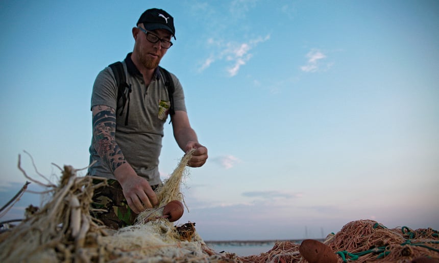
A citizen inspector checks fishing nets in Sant’Agata di Militello, Sicily.
Photograph: Kukka Ranta
In Sicily, fishermen use the fronds as a lure by tying them to floats and setting them adrift.
The shadow attracts dolphinfish (sometimes known as mahi-mahi), which can then be scooped up in a purse-like net. EU regulations state that such devices must be retrieved after use, since they put seabirds and turtles at risk if allowed to drift indefinitely.
The Black Fish says that these rules are often flouted. As four men began loading the palm sprigs onto a fishing boat, Laura discreetly snapped pictures and Dave called Van der Werf at the safe house.
“We’re trying to get the coastguard into action,” Van der Werf told him, ensconced at the kitchen table with his laptop.
“We’ll see what happens next.”
Van der Werf glanced at a Sicilian colleague, a veteran environmental activist named Francesco Mirabito, who began speaking in urgent Italian on his mobile phone, then hung up with a frown.
The coastguard had told him they were unable to act immediately.
Van der Werf was unfazed.
“If we don’t get them this time, it’ll be next time,” he said.
“These puzzle pieces we’re pulling together paint a stronger picture day by day.”
A few hours after Dave and Laura returned to base, Natalie and Maya delivered a triumph of their own: clear footage of a driftnet.
They had grown bolder since their first sighting and had managed to shoot an hour-long video of the gear being unloaded from a boat onto a pick-up truck.
The next morning, Mirabito visited the coastguard office overlooking Santa’Agata harbour, where staff in elegant white uniforms glided along air-conditioned corridors.
An officer listened politely as he explained what the Black Fish had seen, but informed him he could only charge fishermen if they were caught red-handed using illegal gear at sea.
The officer gave Mirabito his mobile number and told him to keep in touch.
We’re really doing hard-core surveillance.
We’re semi-cops; sitting in a car with a long lens, acting like tourists Maya
Van der Werf was waiting outside with several other volunteers in the shade of a sea wall.
“It’s good because it’s a little more clear where we stand,” he told Mirabito, whose frustration was palpable.
“Good work on your part.”
“Honestly, I have not that feeling,” Mirabito replied.
To him, trying to work with the system felt like bashing his head against a wall.
“It’s not news that we’re going to have obstacles thrown in front of us,” Van der Werf reassured him. “It’s all about manoeuvring around them.”
Despite the lack of rapid action by the authorities, the morale among CIs after a week of staking out Sant’Agata remained high.
The Black Fish submitted a dossier of evidence of the use of illegal gear to the European Commission and the National Oceanic and Atmospheric Administration, which manages certification designed to bar from the US imports of tuna caught with driftnets.
“We’re really doing hard-core surveillance,” Maya said, reflecting on her week as the sun set over the harbour wall.
“We’re semi-cops; right there sitting in a car with a long lens, acting like tourists.”
“I just really wanted this net. When I got it – it was like the Holy Grail,” said Natalie, who was nursing a fierce case of sunburn sustained while pacing the quay.
“I don’t feel like I can let this go.”
The overlap between illegal fishing and organized crime has moved up the global agenda lately, and in October, US secretary of state John Kerry announced new initiatives to combat the problem, including using satellite technology to monitor boats in places such as Indonesia and the Philippines.
“There’s a direct line between black-market fishing, black-market drugs, smuggling and human trafficking,” Kerry told the Our Ocean conference in Chile as he unveiled the measures.
“And people need to focus in on that intently.”
While the Black Fish operation in Sicily was focused on documenting illegal gear, the CIs have grounds to wonder whether what they saw might be a small part of a greater criminal enterprise.
Though long-standing links between mafia clans and the fishing industry are difficult to prove, a series of official investigations has yielded glimpses of the scale of organised fisheries crime.
In July, 2000, Italy’s financial police, the Guardia di Finanza, seized three of Sicily’s biggest fish distribution companies on the grounds that they were serving as front companies for the Catania-based Laudani mafia clan.
Prosecutors investigating violations of Italy’s quota for endangered bluefin tuna suspect various mafia organisations are implicated in sophisticated operations to smuggle illicit catches, which can fetch €500 per kilo.
In 2011, the coastguard shed light on the sheer scale of the underground trade when it announced that a year-long investigation in Sardinia had identified a network of 70 suspected traffickers working in outwardly legitimate fish wholesale and distribution companies.
The following year, authorities at Civitavecchia, a port north-west of Rome, seized a record haul of 40 tonnes of bluefin caught illegally in Sicily and packed for export in three trucks.
Despite these successes, the battle against illegal fishing faces serious challenges.
Although Italy’s coastguard has made some progress in the comparatively straightforward task of confiscating driftnets, the campaigning group MedReAct says there is still a degree of official ambivalence towards the use of illegal gear.
Judges have tended to view infractions as “victimless” compliance issues rather than serious crimes, while coastguards from fishing communities may risk being ostracised or worse if they go after their neighbours.
In recent years, officers have also faced a far more pressing task than protecting fish: saving hundreds of thousands of refugees and migrants casting off from Libya.
In a single day last August, the Italian coastguard coordinated the rescue of some 4,400 people.
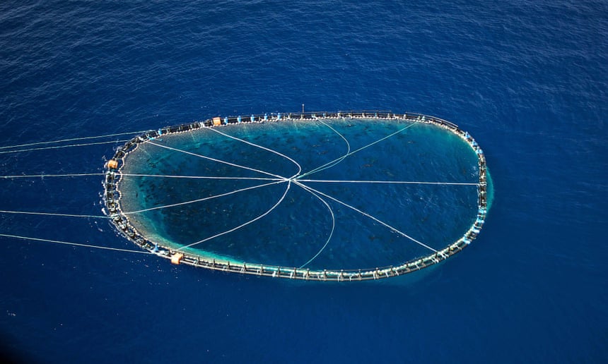
A bluefin tuna cage being towed by an Italian fishing boat in the Mediterranean.
Photograph: Gavin Parson/AFP/Getty Images
Some experts see a further dilemma, arguing that the only way to make a meaningful impact on overfishing would be to reduce the size of the Italian fishing fleet, which has the biggest capacity in the Mediterranean.
The EU aims to put Mediterranean fisheries – 90% of which are over-exploited – on a sustainable footing by 2020, suggesting that Italy and other countries may have to agree to catch less in the short term.
This would be a bitter pill for Sicilian fishermen, already struggling to hang on to family businesses in the face of increasingly onerous and unpredictable rules.
The pain faced by the fishermen has led some to suggest that an enforcement-led approach will be expensive and self-defeating.
Time and money might be better spent helping fishing communities find alternative employment in Sicily, where the eurozone crisis has struck hard and unemployment is at 20%.
For now, however, these more radical solutions are not on the table, and there is widespread political support across Europe for greater scrutiny of fishing grounds.
With his next scheme, Van der Werf’s hopes to take advantage of this political impetus – by launching citizen inspectors into the skies.
It was only just starting to get light when Van der Werf, clad in a navy blue flight suit, and Dan Beeden, a similarly attired 35-year-old private pilot, arrived at a silent hangar on the outskirts of the city of Blackpool in north-west England in late August.
The corrugated iron shed was crammed with a menagerie of aircraft wedged together like pieces of a jigsaw.
The pair pushed a single-engine Cessna 172 onto the runway, donned headsets, then took off into a greyish dawn.
Buzzing south, past Liverpool to the Dee estuary at 1,500-2,000 feet, Van der Werf scoured the mudflats below through a camera lens.
Not content with deploying CIs in cars or on foot, Van der Werf had teamed up with Beeden to cofound a sister organisation to the Black Fish, called the Wildlife Air Service, launched in 2014.
Their plan is to harness spare flying hours among former fighter pilots, airline captains and wealthy hobbyists from the private aviation community to allow CIs to hunt suspicious vessels from the skies.
“We’re just going to over-fly at low tide,” Van der Werf said through the intercom.
“It’s about photographing evidence – quad bikes, tractors, big groups.”
The shellfish issue keeps returning.
This is a form of organised crime, it’s destroying our coastal habitats Wietse van der Werf
Since decamping from Sicily earlier in August, the Black Fish had relocated to a Youth Hostel by the Yorkshire Dales.
For several days, a fresh group of CIs endured the same early starts and long hours as Alpha and Bravo teams – only with less sunshine.
Their observations would be used to guide the flight path of the four-seater Cessna, borrowed from Beeden’s flying club, in a combined air-land operation mounted in defence the world’s least-acknowledged victim of organised crime: the humble cockle.
While the plight of this crinkly shelled mollusc might not ignite much public passion, industrial-scale poaching has devastated cockle beds – a vital link in the coastal food chain – in parts of England and Wales.
There is also a human cost: in 2004, 23 Chinese cockle pickers were swept to their deaths at Morecambe Bay in the north-west of England.
It emerged they had been smuggled into Britain illegally and put to work by an unlicensed gangmaster.
On a blustery morning at the nearby Duddon estuary in Cumbria, a trio of CIs squelched across boot-sucking sand, armed with cameras and binoculars.
Jan, the American volunteer I’d met in Grimsby, spotted two men digging with a fork.
Drawing closer, she felt a twinge of disappointment on discovering they were anglers gathering lugworms for bait.
For Van der Werf, no inspection is wasted – even a blank jigsaw piece is still part of the puzzle.
Though their week-long pursuit of poachers did not yield the kind of evidence clinched in Sant’Agata, the CIs are learning patience.
“The shellfish issue keeps returning in different parts of the country,” Van der Werf said, speaking in the cockpit of the Cessna as the engine cooled.
“This is a form of organized crime, it’s destroying our coastal habitats, and it’s something we shouldn’t stand for.”
Van der Werf’s plans seem to grow bolder every year.
In January, he sought respite from his busy schedule of surveillance missions, celebrity fundraisers and lecture tours by retreating to a snow-bound cottage in Finland, north of the Arctic circle.
There he received an email with the subject line “Good news”: Future for Nature, a Dutch environmental organization, had given him a €50,000 award in recognition of his work.
The prize money could help bring one step closer the next phase of his vision: establishing a 24-hour Ocean Hub to coordinate sea, land and air patrols across Europe.
The criminals reaping the greatest profits from illicit fishing may not yet have heard of the Black Fish, but one day they might.
As Van der Werf is fond of saying: “It’s all possible.”
See how MIT engineers developed a prediction tool that could give sailors a 2-3 minute warning of an incoming rogue wave, providing them with enough time to shut down essential operations on a ship or offshore platform.
New prediction tool gives 2-3 minute warning of incoming rogue waves.
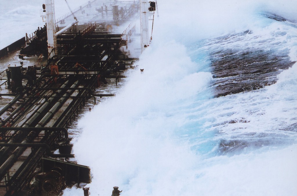
Sailing history is rife with tales of monster-sized rogue waves —
huge, towering walls of water that seemingly rise up from nothing to
dwarf, then deluge, vessel and crew.
Rogue waves can measure eight times
higher than the surrounding seas and can strike in otherwise calm
waters, with virtually no warning.
credit : MIT
Now a prediction tool developed by MIT engineers may give sailors a
2-3 minute warning of an incoming rogue wave, providing them with enough
time to shut down essential operations on a ship or offshore platform.
The tool, in the form of an algorithm, sifts through data from
surrounding waves to spot clusters of waves that may develop into a
rogue wave.
Depending on a wave group’s length and height, the algorithm
computes a probability that the group will turn into a rogue wave
within the next few minutes.
“It’s precise in the sense that it’s telling us very accurately the
location and the time that this rare event will happen,” says Themis
Sapsis, the American Bureau of Shipping Career Development Assistant
Professor of Mechanical Engineering at MIT.
“We have a range of
possibilities, and we can say that this will be a dangerous wave, and
you’d better do something. That’s really all you need.”
Sapsis and former postdoc Will Cousins have published their results this week in the Journal of Fluid Mechanics.
Do you think a boat could withstand the power of a rogue wave in the middle of the ocean?
“Not just bad luck”
Like many complex systems, the open ocean can be represented as a
chaotic mix of constantly changing data points.
To understand and
predict rare events such as rogue waves, scientists have typically taken
a leave-no-wave-behind approach, in which they try to simulate every
individual wave in a given body of water, to give a high-resolution
picture of the sea state, as well as any suspicious, rogue-like
activity.
This extremely detailed approach is also computationally
expensive, as it requires a cluster of computers to solve equations for
each and every wave, and their interactions with surrounding waves.
“It’s accurate, but it’s extremely slow — you cannot run these
computations on your laptop,” Sapsis says. “There’s no way to predict
rogue waves practically. That’s the gap we’re trying to address.”
Sapsis and Cousins devised a much simpler, faster way to predict rogue waves, given data on the surrounding wave field.
In previous work, the team identified one mechanism by which rogue
waves form in unidirectional wave fields.
They observed that, while the
open ocean consists of many waves, most of which move independently of
each other, some waves cluster together in a single wave group, rolling
through the ocean together.
Certain wave groups, they found, end up
“focusing” or exchanging energy in a way that eventually leads to an
extreme rogue wave.
“These waves really talk to each other,” Sapsis says.
“They interact
and exchange energy. It’s not just bad luck. It’s the dynamics that
create this phenomenon.”
A collection or rogue waves/freak waves videos.
Going rogue
In their current work, the researchers sought to identify precursors,
or patterns in those wave groups that ultimately end up as rogue waves.
To do this, they combined ocean wave data available from measurements
taken by ocean buoys, with nonlinear analysis of the underlying water
wave equations.
Sapsis and Cousins used the statistical data to quantify the range of
wave possibilities, for a given body of water.
They then developed a
novel approach to analyze the nonlinear dynamics of the system and
predict which wave groups will evolve into extreme rogue waves.
They were able to predict which groups turned rogue, based on two
parameters: a wave group’s length and height.
Rogue wave sequence showing 60-foot plus wave hitting tanker headed south from Valdez, Alaska. The ship was running in about 25-foot seas when a monster wave struck it broadside on the starboard side. Taken from bridge of OVERSEAS CHICAGO. Alaska, Gulf of Alaska.1993 February.
The combination of
statistics and dynamics helped the team identify the length-scale of a
critical wave group, which has the highest likelihood of evolving into a
rogue wave.
Using this, the team derived a simple algorithm to predict a
rogue wave based on incoming data.
By tracking the energy of the
surrounding wave field over this length-scale, they could immediately
calculate the probability of a rogue wave developing.
“Using data and equations, we’ve determined for any given sea state
the wave groups that can evolve into rogue waves,” Sapsis says.
“Of
those, we only observe the ones with the highest probability of turning
into a rare event. That’s extremely efficient to do.”
Sapsis says the team’s algorithm is able to predict rogue waves
several minutes before they fully develop.
To put the algorithm into
practice, he says ships and offshore platforms will have to utilize
high-resolution scanning technologies such as LIDAR and radar to measure
the surrounding waves.
“If we know the wave field, we can identify immediately what would be
the critical length scale that one has to observe, and then identify
spatial regions with high probability for a rare event,” Sapsis says.
“If you are performing operations on an aircraft carrier or offshore
platform, this is extremely important.”
“The approach is original — it is fast, easy to implement, and it
does not require computational power,” says Miguel Onorato, professor of
physics at the University of Turin, who was not involved in the
research.
“Tests in wave basins and field measurements data are needed
in order to establish reliability of the tool in realistic conditions.”
This research was supported in part by the Office of Naval Research,
the Army Research Office, and the American Bureau of Shipping.


