 Credit: Pixabay/CC0 Public Domain
From Phys by Dinah Voyles Pulver
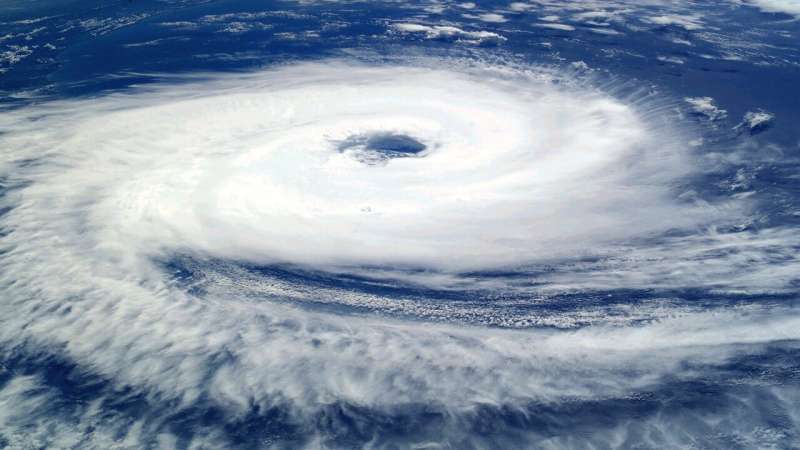
As major hurricanes slam the nation year after year, claiming dozens of lives and costing billions in damages, the impact of climate change on these natural events comes up often in political speeches and casual conversations.
"Could hurricanes get even worse as temperatures rise?" wonders Florida resident Kimberly Lenehan Payano, who survived a harrowing last-minute rescue from Hurricane Ian's massive storm surge.
Scientists have worked for years to answer such questions.
"It's a topic with a lot of nuance," said Tom Knutson, a senior climate scientist at the National Oceanic and Atmospheric Administration's geophysical fluid dynamics laboratory.
The simple answer for the moment: Evidence shows many Atlantic hurricanes are carrying more rainfall than in the past.
It also shows a greater percentage of hurricanes are growing stronger faster.
More people living on the coast and sea levels that already have risen 7 to 8 inches multiply the risks and costs, researchers said.
But it's tougher to determine if human-induced greenhouse gas emissions and global warming have an effect on hurricane intensity and frequency.
Hurricane and
climate scientists agree on some points but see mixed signals on others.
With time and more data, Knutson and others said a more clear picture will emerge.
While people can now watch tropical waves even before they emerge into the Atlantic Ocean off the west coast of Africa, it might be hard to remember scientists barely have 40 years worth of reliable satellite records and data.
So what do we know about hurricanes and climate change? Here's a breakdown:
Are hurricanes producing more rain?
Many climate scientists agree higher rainfall rates are expected in hurricanes in the Atlantic basin with global warming.
The "biggest concerns we have with climate change are with sea level rise and increased rainfall," Phil Klotzbach, a hurricane researcher at Colorado State University.
"Water is the biggest driver of the damage."
With a 2 degree Celsius increase in
sea-surface temperatures, research shows about a 14% increase in near-hurricane rainfall rates, or about a 7% increase in rainfall rates per Celsius degree of warming.
Globally, the average surface temperature has already increased by at least one degree Celsius since the late 1800s.
"When we look at model simulations of hurricanes in a warmer climate, the thing that really sticks out is an increase in precipitation rates in storms," Knutson said.
Scientists don't all agree the effect is discernible by looking at individual storms or that a detectable trend in hurricane rainfall data can be attributed to greenhouse gases.
Kevin Reed, an associate professor in atmospheric science at Stony Brook University, said rainfall is "one of the clearest indicators" of how climate change is impacting hurricanes.
He and a group of collaborators have studied extreme rainfall rates in recent hurricane seasons, including a look at the 2020 season.
The most extreme three-hour rain rates in hurricanes show a 10% increase that can be attributed to climate change, he said.
Reed and colleagues applied that same model to Hurricane Ian and concluded in an era without human-induced climate change, it would have produced 10% less rainfall.
Researchers also found rainfall intensities in landfalling tropical cyclones increase in future climate projections, said Alyssa Stansfield, who completed her doctorate at Stony Brook.
What else causes greater hurricane rainfall?
Hurricanes and
tropical storms have slowed in forward motion over the continental U.S.
since 1900, lingering longer over land, according to an analysis by Jim Kossin, a former NOAA scientist now with The Climate Service.
Scientists don't yet fully understand what causes this change, Knutson said.
Hurricane Harvey lingered over Texas in 2017, dropping up to 50 inches of rain, causing massive flooding in the Houston metro area.
Ian's forward speed slowed to only 8 mph over Florida at one point, drenching Central Florida from coast to coast, dropping 24 inches of rain at Placida near where it made landfall, and 21 inches on the east coast in New Smyrna Beach.
Only Harvey affected a larger area over a single day.
The question of whether greenhouse warming has any impact on the frequency of such stalling or slowing systems is still unsettled, Knutson said, and determining whether the two are linked "will take more work."
Is climate change making hurricanes stronger, with higher wind speeds?
Over 160 years of hurricane history, 12 hurricanes struck the U.S. mainland with winds of 150 mph or more.
Five of those were in the last 18 years, with one each in the last three years: Laura, Ida and Ian.
Warmer water at the ocean's surface from human-induced climate change is likely helping to fuel more powerful tropical cyclones, Knutson concluded with colleagues in a review of tropical cyclone and climate change science published last year.
The percentage of tropical cyclones, ranked by Categories 1-5, that become a Category 3 or higher has increased globally over the past four decades, Knutson said.
The percentage that become Category 4 and 5 hurricanes, with wind speeds of at least 130 mph or greater, "will likely increase with further greenhouse warming."
Klotzbach looked at Category 4 and 5 hurricanes in the Atlantic since 1990, and found an increase but doesn't consider the trend statistically significant because year to year variability makes such significance hard to detect.
Part of the reason for that is so few hurricanes occur in any given year, said Stansfield, now at Colorado State University.
"We just don't have enough data to statistically to say there's been more Category 4s and 5s over the past 40 years, she said.
"We do expect the proportion of Category 4s and 5s will increase as the climate warms."
Is human-caused climate change behind stronger storms?
The intensity and frequency of hurricanes, including
major hurricanes, has increased in the Atlantic since the 1980s but it's not just attributed to greenhouse warming, "because if you look back further, things were also higher in the 1950s and 1960s," Knutson said.
"It's tricky in the Atlantic over short periods to conclude much about the changes we're seeing."
Just as detecting a trend in wind speeds can be challenging, Knutson said, "it gets pretty dicey when you're trying to infer something about greenhouse gas-induced trends in Atlantic hurricane activity."
Studies have suggested stronger Atlantic hurricanes since 1980 could be the result of changes in aerosol effects, ocean circulation or the increase in greenhouse gases.
Are hurricanes rapidly intensifying more often?
Yes, in the Atlantic Basin.
A storm is classified as a "rapid intensifier" when its wind speeds increase by 35 mph or more in any 24-hour period.
Those sudden spikes especially occur in the most intense hurricanes.
National Hurricane Center advisories showed such a burst in Ian's winds twice, between Sept.
25-26 and again on Sept.
28, when its winds increased from 120 mph to 155 mph between 4 a.m.
and 6:35 a.m.
on September 28 as it closed in on the Florida coast.
Kerry Emanuel, a meteorologist and climate scientist at the Massachusetts Institute of Technology, suggested five years ago that rapid intensification would occur more often in a
warmer climate.
Even though that trend might be apparent already, Emanuel said in early 2022 that it will take years of data to be sure.
Some of the increase since 1990 is tied to climate change-related warming, Klotzbach said, but it's unknown how much.
Are tropical cyclones becoming more frequent?
Worldwide, no.
In the Atlantic, yes, although researchers aren't sure why and climate models don't project that to continue.
The 2021 hurricane season was the sixth in a row with above-normal
hurricane activity, even after the 30-year normal was adjusted upward to 14 named storms rather than 12.
However, many things influence Atlantic hurricanes.
The greater number since the 1970s is partially driven by decreases in aerosols, thanks to human efforts to clean up air pollution, said Emanuel and others.
Cleaner air allowed ocean surface temperatures to heat up.
Klotzbach said natural variability, changes in Saharan dust layers and increases in La Niña activity all may contribute.
Will climate change bring more frequent Atlantic hurricanes?
This question is more difficult to answer than others, Stansfield said.
"We just don't understand what controls how many hurricanes per year in general because we don't understand what causes them," she said.
"We don't think there will be more."
That's based in part on work she and Reed completed with one climate model that projected fewer tropical cyclones and fewer landfalling storms in the future.
Recent studies do not imply the increase in tropical storm frequency in the Atlantic since 1980 will continue, states an agency website Knutson maintains.
Most models project future decreases in Atlantic storm frequency in response to rising greenhouse gas concentrations, he said.
A World Meteorological Organization team of scientists reviewed dozens of
tropical cyclones studies around the world and found most projected the global frequency will either decrease or remain unchanged.
Proving climate change 'a tough bar'
Researchers studying hurricanes and
global warming are working to demonstrate whether trends they see in the data could have happened by chance or without
climate change, said Adam Sobel, an atmospheric scientist and professor at Columbia University.
"That's a tough bar, especially with hurricanes, because there's not that many of them."
"There's quite a few (studies) that conclude with pretty good evidence that you can see the intensity increasing.
These other things we're pretty sure they are happening, because there's a line of evidence, but it's not entirely clear," Sobel said.
"People debate whether it's a climate signal or not."
While scientists work toward consensus, the nation should not delay action, he said.
"If you wait until you conclusively prove it couldn't have happened by chance, things might have gotten a lot worse."
Links :

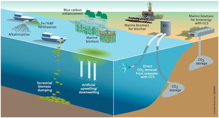 Methods of ocean direct carbon removal.
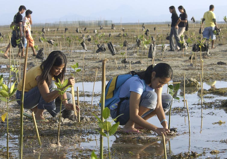 Volunteers plant mangrove saplings in the Philippines.


 Galápagos Penguin. (Credit: Derek Keats)